After a recent dynamic weather pattern over Europe, a strong blocking High is gradually expanding across southern portions of the continent this weekend into next week. The associated heat dome will provide stable weather and the strongest heatwave of the summer of 2023 so far. Parts of Iberia will warm above 40 °C, with parts of France, Italy, and the Balkans into the mid to upper 30s.
The heat has already been intensifying across the Iberian peninsula in the past few days, where areas to the south across NW Africa (Morocco and Algeria) have experienced more than 45 °C this week. On July 6th, for instance, the town of Adrar, Algeria recorded the minimum night temperature of an astonishing 39.6 °C – this is the highest minimum temperature ever recorded in African climatic history.
This heat is gradually taking its turn north over the weekend.
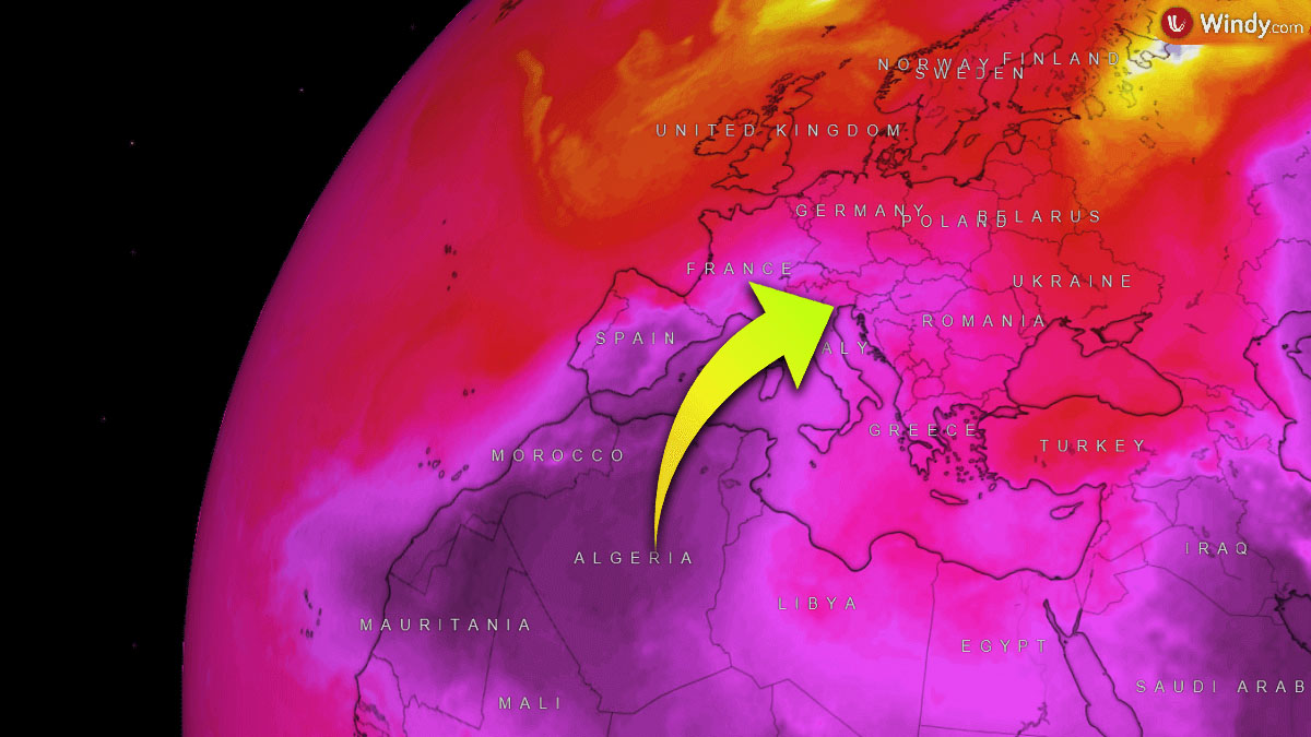
As the heat dome strengthens and expands with time, some heat will expand north across central Europe and the Balkan peninsula. Temperatures there are likely to reach the mid-30s as well. Let’s get into some details of the developing weather.
WHAT IS A HEAT DOME, AND WHY DOES IT BRING EXTREME HEAT?
Let’s quickly review the primary background cause of the upcoming intense heatwave. We used the term heat dome when severe heatwave events occurred in the past, no matter if you live in Europe or the United States/Canada. Usually, it is the dominant feature of summer weather patterns on both continents.
Heat dome will be the term we will use when extremely high temperature develops; here is why.
The upper-level ridge pattern, which we know as the blocking High, normally forms this so-called heat dome. This weather pattern often brings high, sometimes record-challenging temperatures for the region underneath. A heat dome is a term used when a broad area of high-pressure parks over a large portion of the continent. It usually stays there for several consecutive days or even weeks.
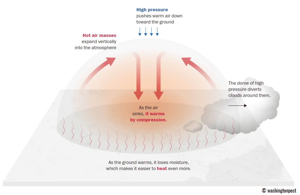
In simple terms, what we could use when debating about the heat dome is that it works like a lid on a pot. The large dome results in the trapping of a very warm air mass at all levels underneath. It becomes particularly anomalous at the lowest elevations. Thus it creates very stable weather and often very dry air mass with minimal chances for precipitation or even clouds. This results in rising temperatures into extreme values because of the sinking air parcels in the center of the heat dome.
Typically, extreme heat is its result, leading to a significantly enhanced wildfire threat due to developing drought or even worsening the ongoing, pre-existing, very dry conditions. Heat dome is often also to blame for being responsible for deadly heatwaves worldwide.
The daily average and maximum temperatures under the heat dome are typically well above normal. They often challenge or even break existing historical records. Especially if the heat dome develops during early summer or early autumn/fall.
HISTORIC HEATWAVE OVER NW AFRICA, GRADUALLY DEVELOPING INTO SPAIN, PORTUGAL, AND MEDITERRANEAN
This week, a blocking weather pattern has been strengthening across NW Africa, gradually expanding into south-southwestern Europe, and is forecast to be a part of the newly developed heat dome this weekend. The heatwave underneath is expected to extend across the Iberian peninsula, most of southern Europe, the Balkans, and partly central Europe. It will last at least 5-7 days, possibly even longer across the south.
Therefore, the weather is favorable for a significant temperature increase across the Iberian Peninsula first. This pattern develops because of a cold drop (upper low) emerging into Western Europe. This establishes a particularly hot southerly flow from northwestern Africa into Iberia and southern Europe.
The southwesterly flow in the upper levels will be advecting hot and dry airmass directly from the desert areas of Morocco and western Algeria. This pattern is known as the “Spain plume.”

As a result, temperatures will be a rather fast increase at the lowest levels of the atmosphere this weekend and will gradually further intensify into the next week. The temperature is forecast to reach more than 26 °C at the 850 mbar pressure level. This is very high for the mid-summer period, thus making this heatwave quite strong for the first half of July.
The strengthening heat dome is resulting in the strongest heatwave of 2023, with scorching heat over the Iberian Peninsula in the following days. Especially southern Spain and Portugal have prone areas for very high temperatures in the past, and it will be rather similar early next week.
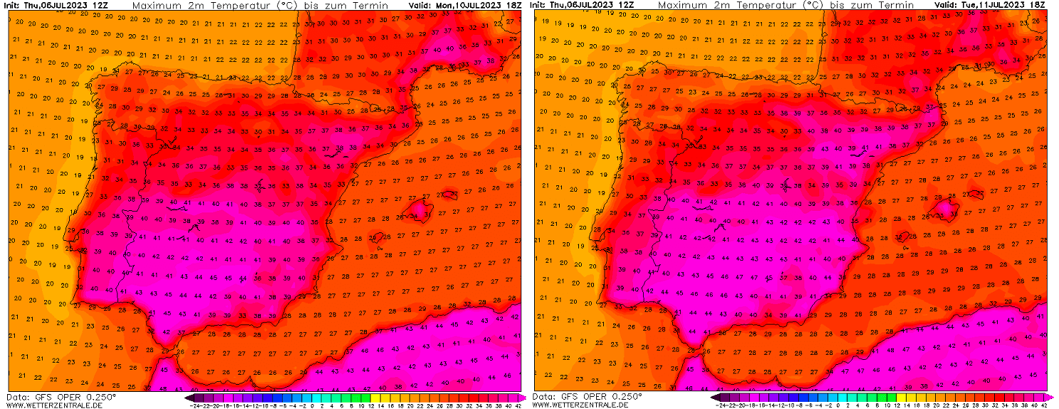
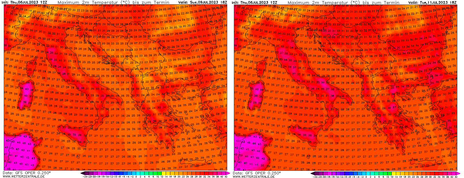
Temperatures are forecast to be the highest on Monday and Tuesday, when the most extreme values of this heatwave are expected. Temperatures across parts of Spain and Portugal could exceed 42-44 °C in the southern regions. Even higher daytime peak temperatures are locally possible, reaching around 45 °C in the most heat-prone valleys.
These temperatures are very high for the early-mid July period in southern Iberia. Attached are the peak temperatures forecast for Monday (left) and Tuesday (right chart) across southwestern Europe. The GFS model hints at even past the 45 °C mark in southwestern Spain.
The city of Montoro holds the national heat record in Spain from August 2021, when the scorching heat of 47.4 °C was recorded. The values forecasted in the next few days will be high but not challenging those records.
HEAT DOME EXPANDS INTO SOUTHERN EUROPE, HEATWAVE INTENSIFIES
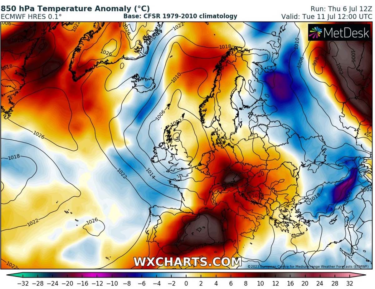
As the general weather pattern stays pretty similar into early next week, the heat dome and heatwave underneath will also spread farther north and east into southern France, Italy, around the Alps, and the Balkan peninsula.
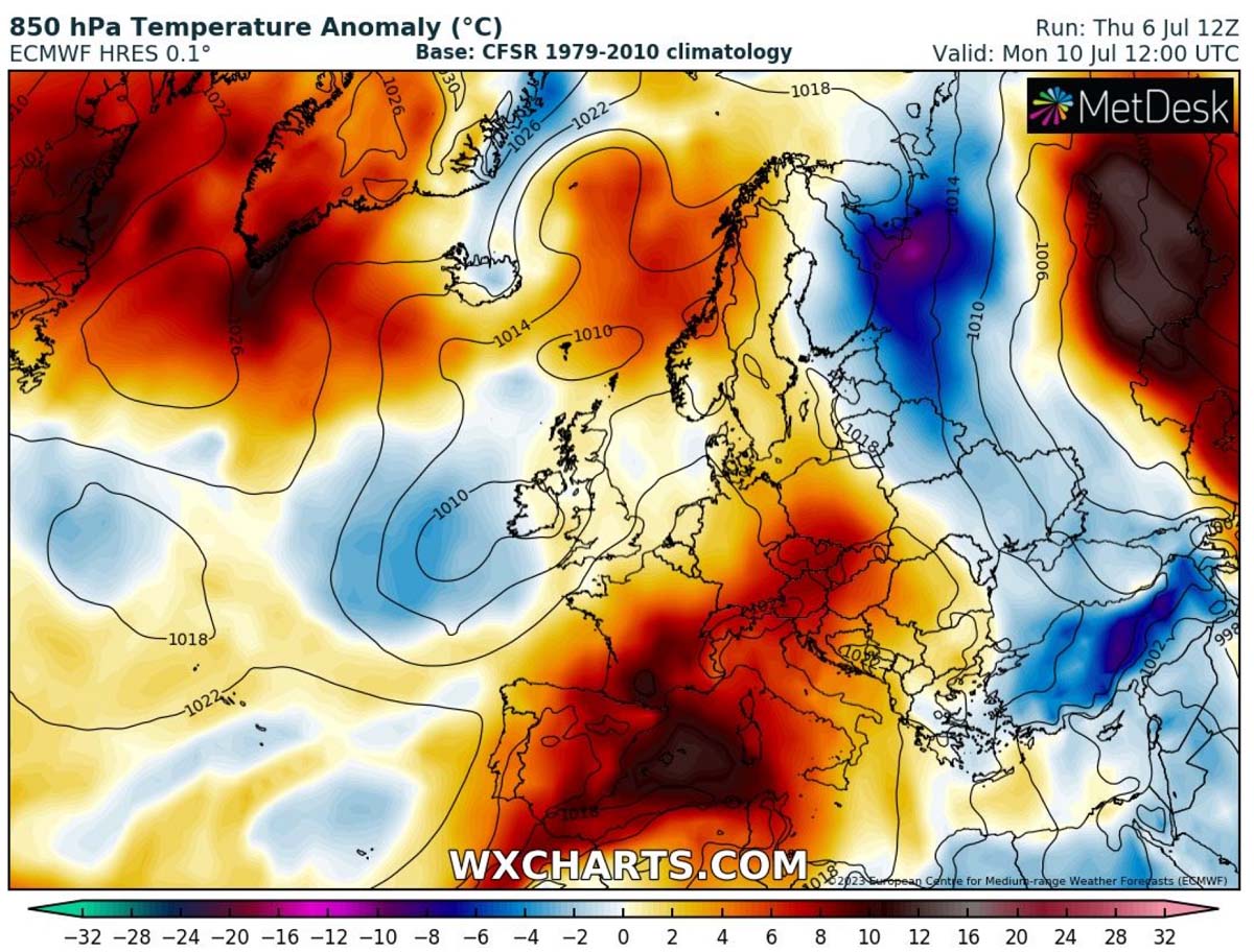
Although the most intense heat is expected for southern Spain, the strengthening upper High over southern Europe will also push temperatures into the mid to upper 30s in Italy and the surroundings.
The warm air will easily advect towards France and south-central Europe with the upper wave sitting over Iberia. Introducing high temperatures at all levels across the atmosphere. The heat dome will be strengthening aloft at the same time, leading the heat to intensify quickly.
As we can see from the 850 mbar temperature anomaly chart above, the temperatures at about 1250 m above the ground rise to more than 15 °C above normal for mid-July. This means that the exact temperature values at 850 hPa (approx. 1250 m ASL) are forecast to reach 22 to 25 °C in the first part of the next week, particularly in southern Spain and most of the Mediterranean.
So high temperatures at these levels will not only bring very high temperatures for the higher elevations but also translate to the ground levels as air masses are sinking underneath the dome of heat. Temperatures will be higher from Saturday through Wednesday next week, as the upper High is forecast to be the strongest on Monday.
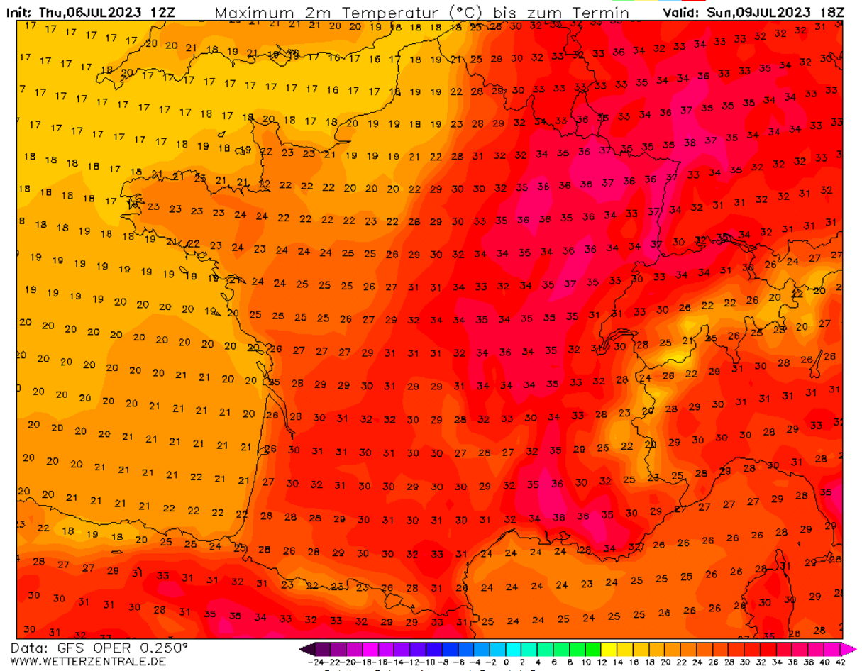
Temperatures will be the highest in southern and southwestern lowlands, with extremely high temperatures in Spain. All-weather models across the southern half of Spain warrant the scorching heat. France will see the highest values on Sunday, as seen on the chart above.
The heat wave intensity will be spread over the Mediterranean from Sunday through Tuesday. Italy could be experiencing peak afternoon temperatures in the upper 30s. At the same time, the 40 °C mark isn’t out of the question in some lowlands either.
The Balkan peninsula will also gradually warm up into low to mid-30s after Sunday. However, extreme heat is not expected.
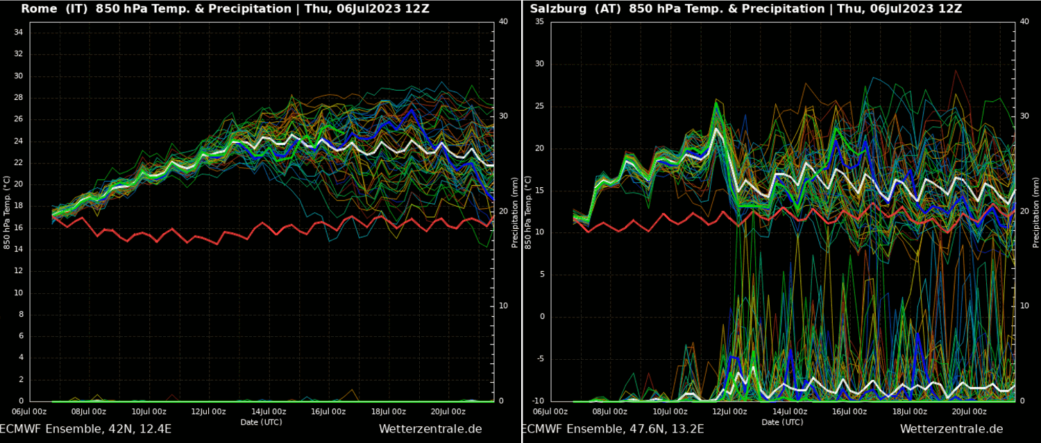
The below Meteogram forecast chart for Rome, Italy, and Salzburg, Austria (northern Alps) reveals an impressive prolonged heatwave for central Italy, with no signs of rain but persistent, very warm mid-levels. Thus leading to long-lasting heatwave.
The right chart for Salzburg indicates that the heat might be of a short breath for this part of central Europe, ending by mid-week as the upper ridge remains farther south over the Mediterranean. More dynamic weather could follow afterward.
The upcoming very hot and dry air mass will undoubtedly worsen the ongoing drought conditions in France, Spain, and Portugal, as well as across parts of Italy.
HOW LONG WILL THE HEATWAVE LAST, AND COULD SEVERE WEATHER DEVELOP AFTERWARDS?
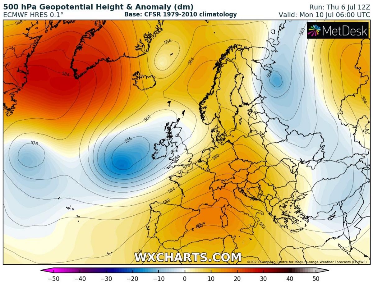
The heatwave will likely vanish across central Europe mid-next week from north to south as the intrusion of the upper wave from the North Atlantic moves to the east. Normally this leads to lowering geopotential heights from Western Europe into the Bay of Biscay and towards France.
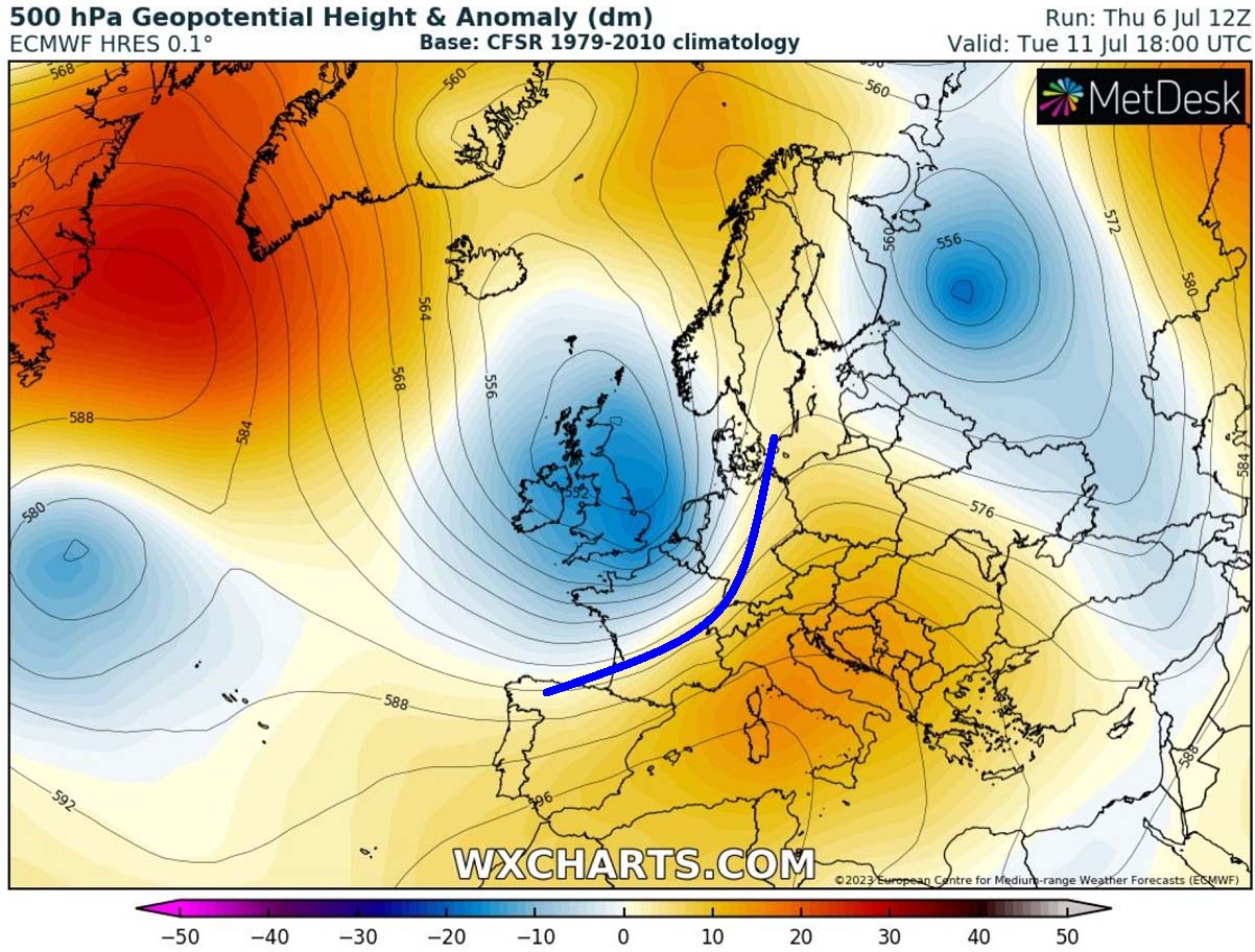
The 500 mbar anomaly chart above by the ECMWF forecast model indicates the development of a large upper wave/low across western Europe, expanding east. The potential cold front is marked with a blue curve. Although this means temperatures would increase towards southeast Europe, areas in between the two large-scale features could see a return of severe weather.
So, after the strong heatwave over southern Europe this weekend and early next week, we could see more progressive weather patterns developing through mid-July, depending on how the trough from the Atlantic digs deeper into the overheated European continent. This could cause another round of more dynamic and stormy weather.
Windy, Wetterzentrale, and Wxcharts provided images used in this article.
See also: