As we head for the last Winter month of February, the weather will also be influenced by an emerging MJO wave in the western Pacific, putting its own spin on the weather circulation.
We already discussed the importance of large scale weather influencers like the La Nina and the Polar Vortex. But now, a new weather anomaly is emerging from the tropics, which has a more short-term (faster) influence.
GLOBAL WEATHER CONNECTIONS
Global weather is a very complex system, with thousands of different factors that can influence its development. No matter the time or place, the weather is connected globally, as one big (chaotic) system.
Below we have a high-resolution video, which shows one good example of a global weather connection. The video shows the atmospheric moisture supply, in the form of available precipitable water.
Take note of how the tropics provide moisture to larger weather systems. There are also a lot of other weather influences between the tropics and the Polar regions, but this is a very simple and effective way of showing the weather connections.
Looking at the global ocean analysis, we can see the equatorial Pacific ocean being quite colder than normal. This is also known as La Nina and has important long-term effects on weather development.
As the Ocean is forcing out the La Nina onto the weather, we are now also tracking an atmospheric MJO wave emerging from the west Pacific ocean.
A lot of the tropical variability is driven by invisible wave-like features in the atmosphere. The largest and most dominant source of short-term tropical variability is the Madden-Julian Oscillation, know short simply as MJO.
But what is this MJO wave? This oscillation is an eastward moving disturbance (wave) of thunderstorms, clouds, rain, winds, and pressure. It moves around the entire planet on the equator in about 30 to 60 days. It has the power to influence the weather patterns further north over the North Hemisphere, as there is a strong connection between the tropics and the global weather.
The MJO consists of two parts: one is the enhanced rainfall (wet) phase and the other is the suppressed rainfall (dry) phase. The graphic below from NOAA Climate shows the basic dynamics of this wave. Increased storms and rainfall on one side and reduced storms and drier weather on the other side.
What we can see here, is that on the top, the air is diverging (moving away) over the wet phase, and converging (moving together) over the dry phase. This horizontal movement of air is referred to as the Velocity Potential in the tropics.
This way we can track entire weather waves across the globe, by looking at the larger scale air movement, and the areas where the air is rising, and where it is subsiding.
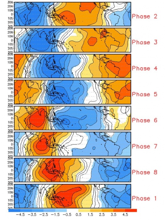
The graphic below shows exactly that. It shows the horizontal movement of air in the upper levels (~12-13km), where cold colors show lower surface pressure and wet weather, and warm colors show drier weather with fewer clouds and precipitation.
It is important to see how this wave is consistent enough to be arranged into phases. Each has its own influence on the weather, which is why we need to keep track of how it is moving around the globe.
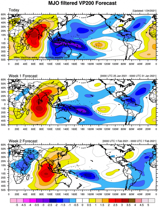
The next image below shows the actual state and the forecast of the wet and dry parts of this wave. We can see the active part of the wave with frequent thunderstorms and precipitation emerging from the Maritime continent into the West Pacific ocean. This corresponds to the phase 6 and 7 on the previous image.
A special forecast graphic also shows the movement of this weather wave through the phases. We can see it is forecast to end the month of January in phase 6 before moving into 7.
FEBRUARY WEATHER EVOLVES
Below we have an image from JMA, which shows the average global pressure pattern during phase 6 in January in the past decades. Such composites serve as guidance when we want to find out how the weather might develop.
The most important takeaway is the low-pressure area over western Canada and the northwestern United States, and a high-pressure area over eastern Canada and the United States. We can also see lower pressure over north and northwestern Europe.
Looking at the actual forecast below for the final days of January, we can actually see a very similar weather pattern. Low pressure over the western United States and Canada and high-pressure in the east. Over north and northwestern Europe we can also see the same low-pressure area as indicated in the guidance image above.
This gives confidence that we can actually see a weather pattern evolving under the influence of this phase 6 of the MJO. There is never a perfect match between historic patterns and real-time weather patterns, as the global influences are never exactly the same. But a signal is present that indicates an effect from the tropics.
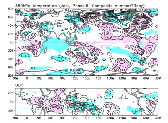
Going to the actual weather, the historic pattern for the January phase 6 shows colder temperatures in western Canada and the northwestern United States. Southern and eastern Untied states are under milder, warmer than average weather. Western Europe is under warmer weather also, while northern and eastern parts are trending towards colder weather.
The actual weather forecast below, for the final days of January, shows a very similar development, as the historic composite above. This is a strong sign that the MJO wave is indeed having a likely interference with the weather development.
Colder than normal weather is expected in western Canada and also the western United States, while milder conditions prevail over the central and southern parts. A low-pressure system is outgoing, pulling some colder air into the northeastern United States.
Just like in the historic pattern, we can see Europe warmer over the western parts and colder over northern and eastern parts.
Below is our snow depth change forecast image, which shows the snow depth change from today till early February from the GEFS model.
We can see a reduction in snow cover over the central United States and central Europe, as a result of milder weather. Snow cover increase is expected across western Canada and the western United States. In Europe, we also see an increase over Scandinavia, across eastern Europe, and the Balkans.
Going forward, the MJO wave is expected to go into phase 7, as we can see in the forecast image below. There is less confidence in these forecasts at this range, but we will look at what this might mean for the weather development and if we can find a signal in the forecast.
First, we have produced a composite image of the historic February phase 7 weather patterns. What stands out is the lower pressure over northern and eastern United States and Europe. We can also see lower pressure over the Bering Sea. High pressure is present over the western United States, and also in the North Atlantic across Scandinavia.
The actual weather pattern forecast for early week 2 of February, shows some similar points. We have lower pressure over the eastern half of the United States and higher pressure over the western part. Europe is also under lower pressure, with high pressure extending from the North Atlantic into the polar regions and Scandinavia.
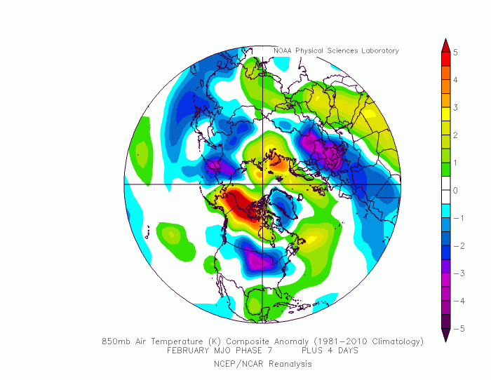
The historic temperature composite for phase 7, shows colder air in the northern, central, and eastern United States, with warmer weather in the southeast. Another batch of colder than normal weather is over central and southern Europe.
The actual forecast is not exactly the same. We do see colder weather over much of the United States, with warmer than normal over the southeast. But this is an ensemble forecast for 15 days in advance, so there is some noise in the forecast. A more likely scenario is colder weather across the central and eastern parts of the United States.
Over Europe, we see colder air over northern and central parts, while southern parts are under milder warmer weather conditions.
Snow depth forecast from day 10 to day 16, shows a pretty decent snow depth increase signal over north and central United States. A snow depth reduction (melt), is indicated for the northeastern parts. That is likely due to brief southerly flow, while the low-pressure area sits over the central United States as it progresses from the northwest towards the east.
FEBRUARY WEATHER IN THE SECOND HALF
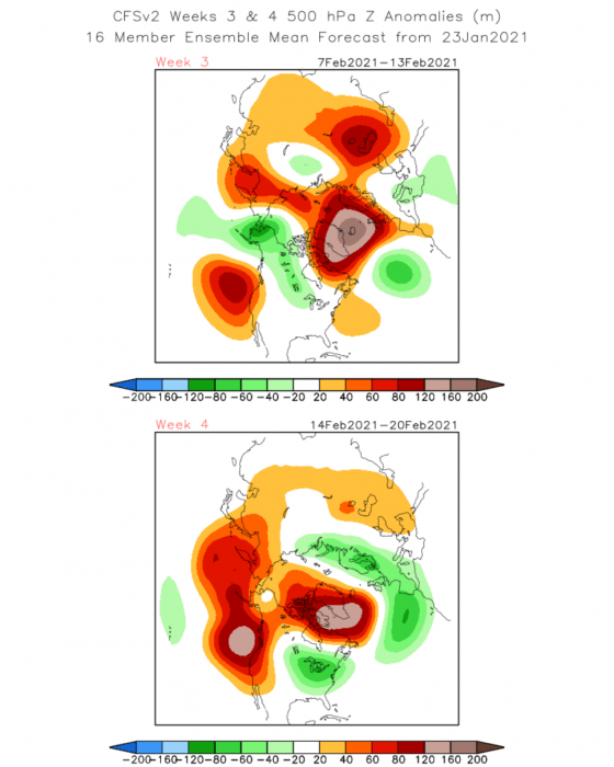
Taking a quick look at the second half of the month, the weather pattern seems to take a step back. We see the dominant high-pressure system over Greenland and northeastern Canada and a separate one in the North Pacific. This influences the lower pressure over western Canada and the northwestern United States, and also over Europe.
Weather response to such a pattern is expected, with colder air being more confined to western Canada and the western United States while the eastern half is under higher pressure and warmer southerly flow.
Europe is also divided, with colder weather conditions more confined to the northern and central parts, while southerly flow keeps southeastern parts under milder conditions.
Looking at the CFSv2 weekly forecast below, we can see a similar idea, with the strong blocking high over North Atlantic and Greenland, and lower pressure areas over Western Canada and Europe on each side.
Later in the month, the high pressure from the Pacific is set to amplify, forcing lower pressure over the continental United States. That promotes colder weather conditions across central and eastern parts, as colder air is being transported from the north.
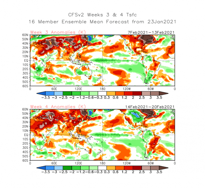
The temperature forecast shows this idea, as we can see on the image below that colder anomalies prevail over south-central Canada and most of the central and eastern United States.
Europe is under mixed weather conditions, as colder weather prevails for the northern parts and warmer for the south. This is an inverted scenario, due to the low-pressure area sitting over the continent. This can mean a few mixed weather conditions, as the low-pressure area is never really stationary for this long, and can wave in and out, causing great weather variability.
The MJO forecast is showing progress into phase 7 as we have seen already. But later in the months, we can see above, we have colder conditions over the Eastern United States. This could mean that the progression into phase 8 is the next step, not yet visible on the forecast charts.
Below is a composite, showing temperature over the United States in different phases during winter. Phase 7 is exactly what we have shown above, with warmer east and colder west. But in 8, colder weather prevails in the central and eastern United States and warmer in the west.
Taking a closer look at the forecast for the second half of the month, we can see the transition from the warm eastern United States, to colder in the central and east and warmer in the west. This could be a response in the model to the shift into phase 8.
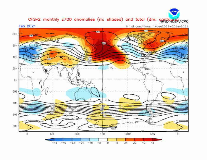
Taking a general look at the weather pattern for the month of February 2021, we can see a strong high-pressure system in the North Pacific. It is connected to the Polar Circle and with the high-pressure system over Greenland. This forces a response in the lower pressure over western Canada and the northwestern United States, and also over much of Europe.
This pushes the jet stream more towards the south, which can cause an inverted weather pattern, especially over Europe. There we can have a more easterly flow, as low-pressure areas over the continent spin counter-clockwise, pulling the colder air from the east over northern parts, and warmer over the southern parts.
Over North America, we see the dominating lower pressure area over western Canada and the northwestern United States. This allows for a window where individual cold air outbreaks can proceed from the northwest down into central and southern United States, also progressing towards the east. A lot depends here on the positioning of the high-pressure system over eastern Canada and Greenland.
We will keep you updated on further development, as we will make a more detailed weekly forecast breakdown for weather development in February 2021 in the coming days, as updated model guidance will be available.
DONT MISS:


