Active Polar Vortex above North America takes no break. Next week, its southern lobe will generate another significant, frigid cold Arctic Blast from Canada into the United States, sending temperatures back into the deep freeze 40-50 °F below average. Before the Arctic blast arrives, a powerful Winter Storm Jett will impact the Northeast U.S.
The Polar Vortex disruptions aloft have established extreme weather conditions, with long-lasting Arctic cold outbreaks and intense winter storms this month. On Sunday, a Winter Storm Jett will blast part of the Great Lakes and Northeast U.S. with intense snowfall, freezing rain, and snow blizzards.
Then, another significant Arctic cold outbreak follows next week. The frigid cold air mass has maintained over much of Canada and the northern U.S. over the last two weeks and is forecast to plunge far south across the nation in the coming days. Temperatures are forecast to push back into a deep freeze, with 40 to more than 50 degrees F below normal for tens of millions across the North American continent.
The significant cold will intensify across the Northern Plains on Sunday and gradually spread south and east across the United States next week. By mid-week, the Arctic cold pool will reach deep South to the Gulf and East Coast by Friday. Brutal cold days and locally historic, record-low temperatures are forecast.
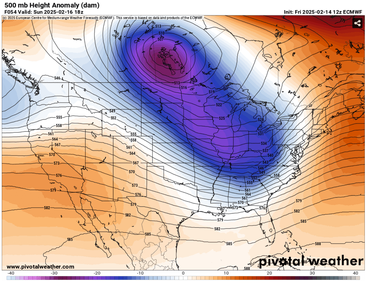
The upcoming weather pattern will strengthen the mighty upper-level ridge over Arctic Canada, with lower geopotentials towards central North America. This pattern results in an extensive frigid cold air mass reservoir, intensifying the surface high-pressure system and dragging extremely low temperatures far toward the south.
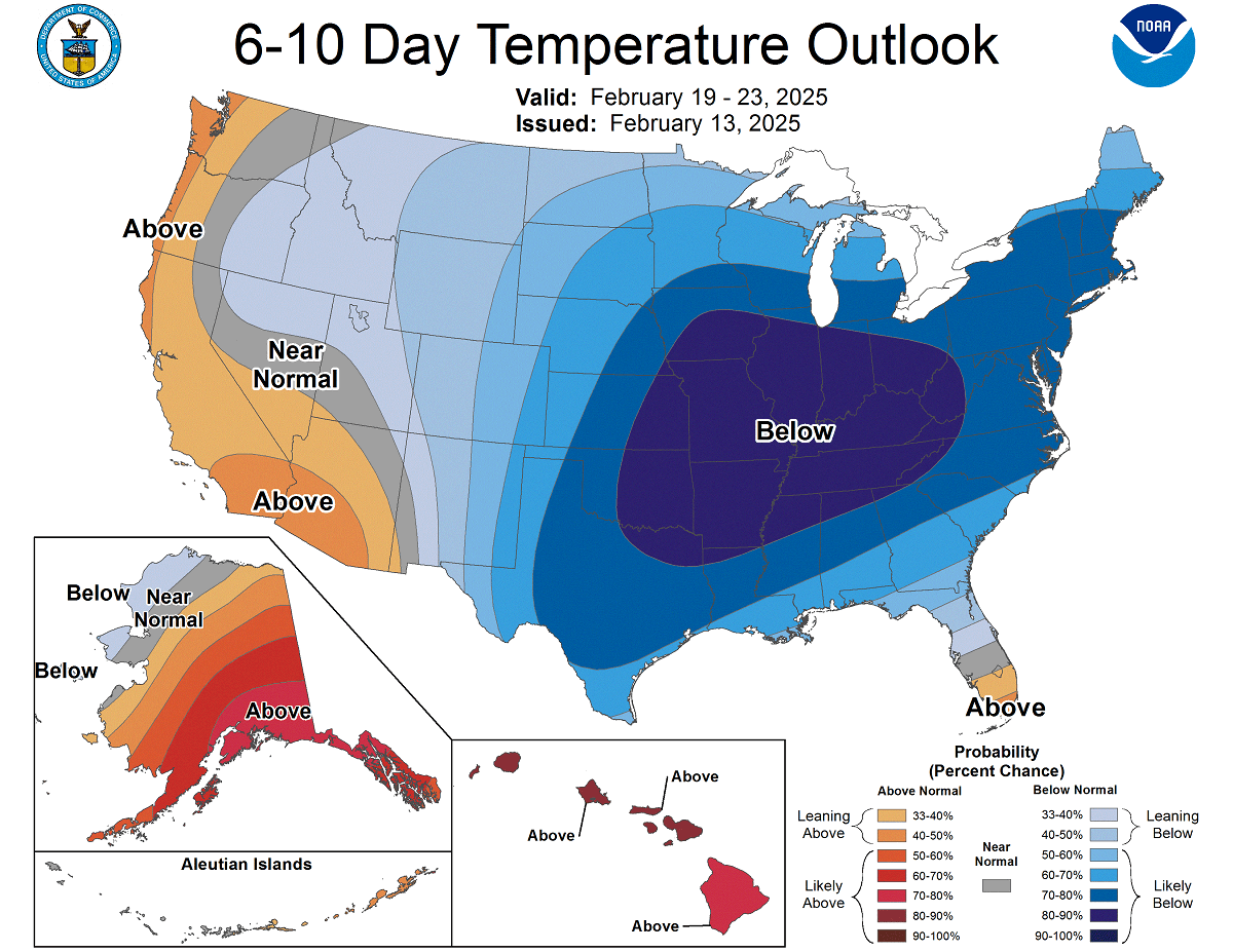
The second half of February will be much below normal, as the NOAA forecast represents their 6-10 day temperature outlook.
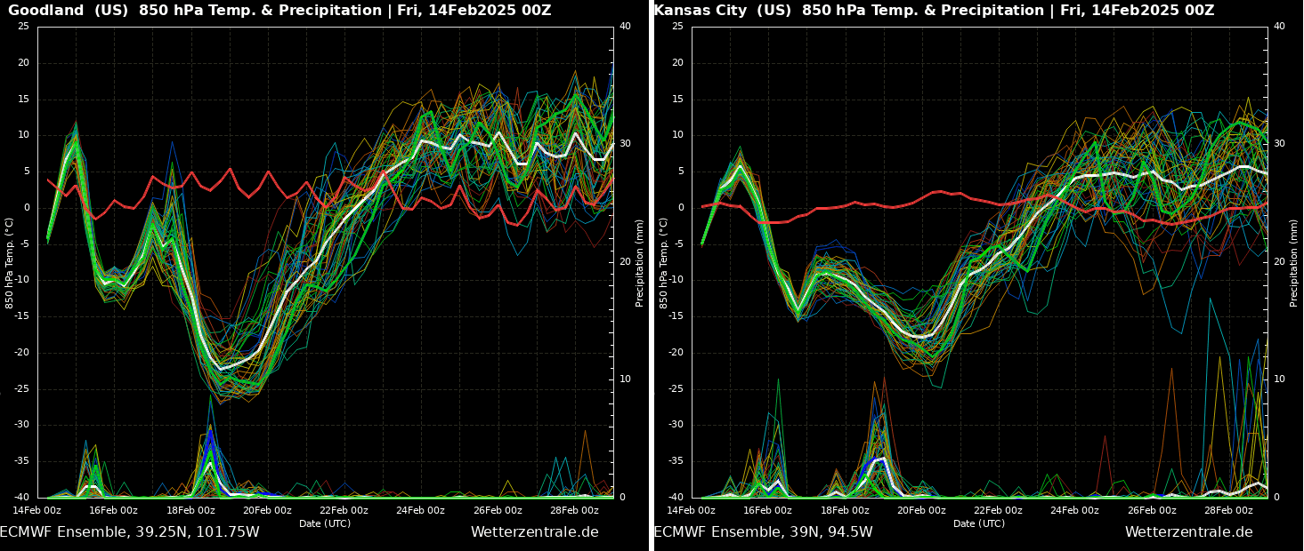
The progress of the Arctic cold pool will be rapid, as the following temperature charts over Goodland, KS, and Kansas City, MO, show. A sharp decline in temperatures will engulf a large part of the nation into a deep freeze.
The High Plains, from Wyoming to Colorado and western Kansas, are forecast to experience an extreme temperature drop of nearly 30 degrees in about 36 hours.
So, the progress of the extreme cold pattern over Canada will intensify this weekend and spread across the northern United States by Sunday and Monday before it plunges further south next week.
The video animation below provides a quick overview of the next 10 days. Judging by temperature anomalies, the frigid cold air mass will send tens of millions into a deep freeze.
Before we discuss the details of the upcoming event, we want to consider the main trigger behind these events. The historic Arctic blasts often follow a substantial disruption of the Polar Vortex aloft.
This February, its southern lobe shifted over North America, so the cold air mass outbreak will intensify and push far south towards the Gulf Coast again.
What is the Polar Vortex?
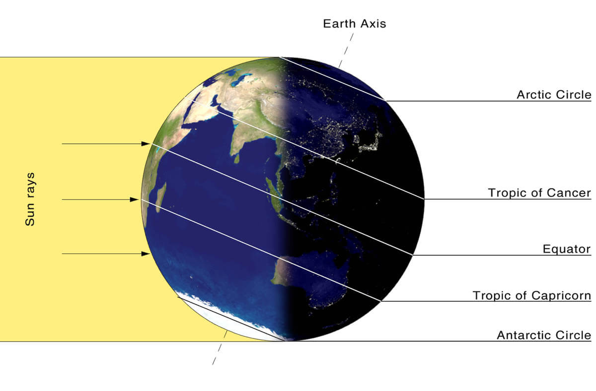
The Earth’s atmosphere has six layers around the planet. Most of the dynamics for our daily weather occur in the lowest two layers, known as the troposphere and the stratosphere.

The troposphere is the closest layer to the Earth’s surface. It is about 12 km deep and extends from the ground up high into the sky. Depending on where you live, its depth varies from around 8 km to almost 20 km. The troposphere is the deepest above the equatorial region and gets much thinner above the North and South poles.
Above this layer is a much deeper one known as the Stratosphere, an 11-50 km thick layer of arid air. The stratosphere also contains the ozone layer, which protects our planet’s life against the potential impact of solar storms from the Sun or outer space.

Another essential feature in the stratosphere, which makes our weather even more variable, often triggers significant large-scale and long-lasting winter weather events. This is the Polar Vortex—an enormous, tri-dimensional ring of powerful winds moving through the sky above us. The Polar Vortex is spinning around the North Pole, grazing through the air at about 20-50 km above the Earth’s surface with violent wind speed.
The troposphere and stratosphere are crucial for our climate. The Polar Vortex covers most of the bottom half of the atmosphere. Since the vortex extends from the middle of Earth’s troposphere into the stratosphere layer, it significantly affects winter weather across high and mid-latitudes yearly.
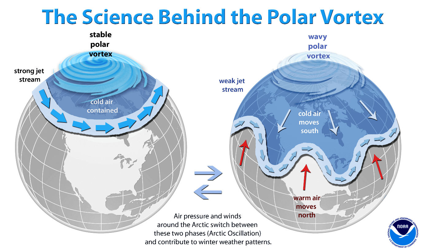
We have experienced this in Asia, Canada, the U.S., and sometimes Europe in recent years. The vortex aloft has been significantly disrupted, and when its lobe shifts on the other side of the northern hemisphere, the extreme cold grips the North American continent.
The Polar Vortex is most substantial during winter in the Northern and Southern Hemispheres. Although it spins well above our heads, it remains closely connected with the lowest parts of our atmosphere. Thus, it influences our daily weather in many ways, functioning as one sizeable hemispheric circulation.

The Polar Vortex has triggered the most intense weather systems, from frigid cold outbreaks and winter storms in Canada and the United States to Asia and Europe. Although it affects the whole Northern Hemisphere, its main impact occurs where the southern lobe of the vortex is located.
How and when does the Polar Vortex form?
Due to the Earth’s inclination, the polar regions receive much less energy from the Sun during the fall months. This causes the cooling over the northern areas to become more robust. As a result, polar nights also occur for several consecutive months, followed by days without sunlight.
While the temperatures in the polar region are dropping into a deep freeze, the atmosphere layers farther to the south are still relatively warm since they receive more of the Sun’s energy simultaneously. Therefore, the south’s equatorial layers remain much warmer than the areas farther north, leading to a high-temperature contrast.
Cooling the polar regions also lowers the ambient surface pressure, and a similar weather process occurs in the stratosphere. The temperature difference between the North Pole and the equatorial areas increases across both layers. This creates a large low-pressure cyclonic circulation across the polar stratosphere, where this feature takes its famous name—the Polar Vortex.
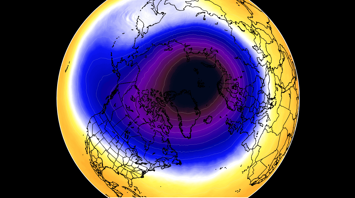
Putting all these puzzle pieces together, the Polar Vortex is an enormous cyclone in Earth’s atmosphere. During winter, it expands across the North Pole and sometimes becomes very intense, extending south to the mid-latitude regions. The same happens in the southern hemisphere during winter when the Polar Vortex intensifies around the South Pole.
The weather model chart above hints at a typical situation when the Polar Vortex is fully established above us. It represents the pressure at around 30 km (18 miles) altitude, located near the top of the stratosphere layer during winter.
The active and strong Polar Vortex during the Winter season of 2024/25 was the main trigger behind the robust cold outbreaks in Siberia since January.
Then, the most intense part of the vortex, the southern lobe, shifted to the North American side of the northern hemisphere and spread across Arctic Canada towards the U.S. From now on, all the fun begins.
A powerful Winter Storm Jett will impact the Great Lakes and Northeast U.S. with deep snow blizzard on Sunday
While the Polar Vortex aloft has strong blocking over the Arctic region, troughs are developing further south. This weekend, another deep upper wave drags on the edge of the significant Canadian cold pool, moving across southern Canada and the U.S.
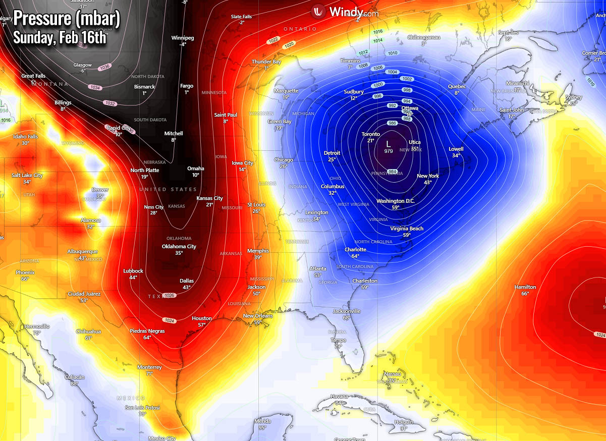
Its core will develop an intense surface low over the central U.S., rapidly strengthening while racing toward the Northeast on Sunday. The central pressure will fall below 980 mbar and develop a powerful Winter Storm Jett.
Storm Jett will be a considerable cyclone engulfing much of the eastern United States and southeastern Canada. On Monday, it is forecast to deepen further as it moves towards Nova Scotia and Newfoundland.
The winter storm Jett will develop across the central Plains on Saturday during the day. Rapidly deteriorating weather conditions will occur as the low begins rapid intensification Saturday night, moving across the Ohio Valley into the Great Lakes and towards the Northeast.
Beginning Sunday morning, heavy snow is forecast from Indiana, Ohio, and southeastern Michigan, with intensifying northwesterly winds. The storm will continue intensifying and tracking across the Great Lakes and Northeast during the day. A sharp contrast between the warmth in the south and the cold in the north will develop.
The following chart indicates the approximate position of the storm Jett on Sunday midday. The sharp temperature gradient along the storm’s path will intensify precipitation. It will bring heavy snow and blizzard to the north of the warm front and freezing rain with sleet to its immediate south.
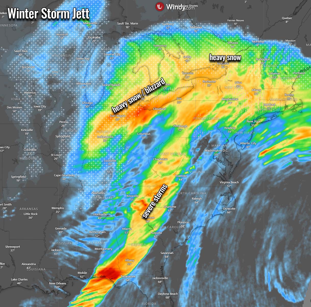
The most significant amounts of snow are forecast across eastern Michigan, northern Ohio, Pennsylvania, New York, Vermont, and Maine states, including southern Ontario, Canada. In 24 hours, a swath of 1-2 feet of snow could blanket millions from Detroit and Toronto to Quebec.
Overall, many areas will likely receive significant fresh snow by Sunday night. Once the storm’s core passes, lake-effect snow is expected to trigger, adding additional heavy snow eastbound to Lake Erie and Ontario. Two to three feet of snow will be possible.

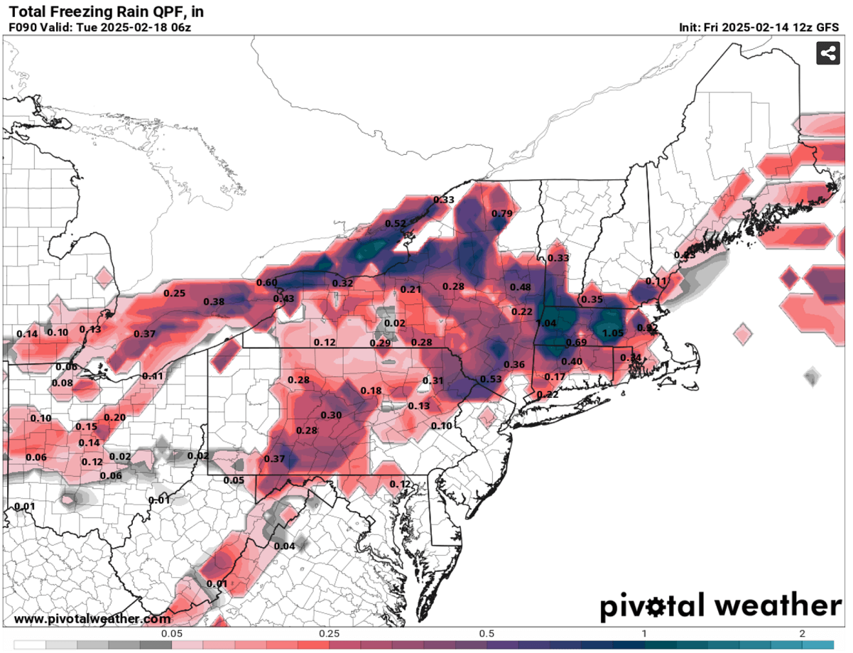
A significant deep low also brings strong warm advection from the south. A warmer mid-level air mass will overspread the cold conditions beneath, forming a sharp surface temperature gradient. Thus, this scenario becomes favorable for producing freezing rain and sleet.
Therefore, freezing rain and ice are possible across Pennsylvania and New York state and around the lakes in southern Ontario. Locally, 0.5 to one inch of black ice could accumulate by Sunday afternoon when precipitation finally turns to heavy snow. Travel disruptions, including power outages and falling trees, could occur.
Further south of the center low, a sharp cold front will develop severe thunderstorms with heavy rain and strong to severe winds, including tornadoes from the Mississippi Valley eastward to Alabama Saturday night through Sunday as the fast-moving cold front races east.
Another frigid Arctic cold blast will spread across the U.S., sending millions into deep freeze
The general weather pattern foreseen over North America next week hints at a large-scale blocking ridge developing over the Arctic region. To its south, a deep wave will develop over Canada and spread into the U.S. by mid-week. As it digs south and east, it will also intensify further.
In response to significantly colder temperatures descending from the upper levels towards the lowest levels of the atmosphere, the surface pressure will push into extremely high values. Establishing an extensive high-pressure system across most of Canada and the United States.
This is a typical evolution as cold weather is denser than the warm air mass, so the pressure underneath the Arctic cold significantly rises. The following chart represents the surface pressure next Thursday, with around 1055 mbar across southern Canada and the northern High Plains.

The highest pressure is a general hint where the most potent cold develops while it gradually descends southward with time on Sunday into the following week. Temperatures will plunge into deep freeze.
The extensive Arctic cold pool is forecast to intensify over Canada this weekend. On Sunday, it begins its gradual but rapid advance south with the Arctic front across the U.S. Coming from the Arctic region, the brutal cold temperatures will spread from Alberta and Saskatchewan, Canada, south across Montana, Wyoming, and the Dakotas. They will continue south in the early days next week.

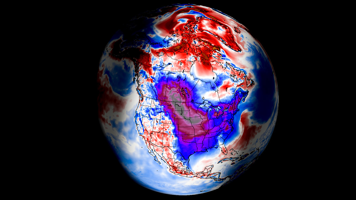
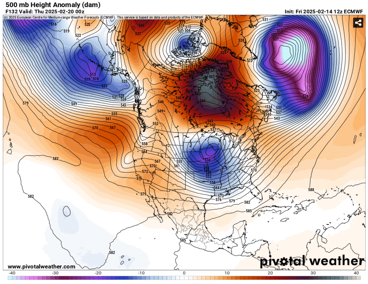
The above chart represents the 850 mbar temperature anomaly for Wednesday evening, Feb 20th, 2025. Extremely anomalous temperatures grip central parts of the U.S., the most extreme across Wyoming, Nebraska, South Dakota, Colorado, Kansas, and the OK/TX Panhandle.
On Thursday, the cold pool will advance across the central U.S. toward the east and south, reaching Texas, the Gulf Coast, and Mexico by the evening. Since it remains extremely cold in the north, the frigid Arctic airmass will be deep and extensive, dominating a large part of the nation. It will also become very cold across the Southeast U.S. on Thursday.

The progress of the Arctic Blast results in hazardous, frigid cold conditions across southern Canada and the north-central U.S. states from Sunday through multiple days of the following week to at least Friday, possibly extending into the following weekend.
Daily temperatures across southern Alberta, Saskatchewan, Montana, Wyoming, and Dakotas will be 45 to 60 °F below normal for mid-February, posing a high risk of hypothermia for those exposed outside for too long. Conditions will be extreme.

As the cold pool core progresses east and south on Thursday, the frigid cold air mass at the surface will bring temperatures 30-40 degrees F below across the Central Plains and Midwest.
Winds will not be assertive, as the high pressure will establish calm but extremely cold conditions. However, any wind occurring will worsen the real feel as windchill temperatures become brutally low—even below -50 °F in the north.

An Arctic blast reaching the deep south will bring Texas and the Lower Mississippi Valley to 20-30 °F below.
Temperatures will remain frigid low for days, -15 to -20 degrees F across the north during the nighttime hours and near 0 degrees during the day on Tuesday and Wednesday, with single digits as far south as Kansas, Missouri, and Illinois. Temperatures will remain above freezing only from central Texas to the Southeast U.S. during mid-week.

On Friday, the core of the Arctic blast will mature over the central United States, bringing the most significant, frigid cold temperatures across the Midwest and central Mississippi Valley. Temperatures will be 40-50 °F below the average. Winds will make conditions even worse, and windchill temperatures will be extreme.
The cold pool will also be maintained in the South, with 20-30 °F below normal from Texas to the lower Mississippi Valley. It will intensify across the Southeast U.S. and the East Coast as the Arctic Blast continues east into the following weekend.

The frigid cold will gradually lose its strength over Canada late next week, and temperatures will return to near normal for late February. The final days of February could also bring warmer weather across much of the United States.
We are closely monitoring the evolution of the ongoing pattern and will update you accordingly. Stay tuned.
Wxcharts, Windy, and Pivotalweather provided images used in this article.