A new Polar Vortex is forming in the Stratosphere over the North Pole. It is strengthening rapidly and will continue to strengthen towards the Winter of 2023/2024. The Polar Vortex has a long and strong history of Winter weather impacts over the United States, Canada, and Europe, especially if it starts to collapse.
The word Polar Vortex can mean many different things. But for us, it reflects the strength of the stratospheric polar circulation. For our Winter weather, it only matters whether it is strong or weak, creating a totally different weather outcome in Winter at the surface.
First, we will look at what is the Polar Vortex, why do we care about it, and why should you? We will also examine its connection to another stratospheric anomaly occurring this year and to the emerging El Niño, all coming together for Winter 2023/2024.
POLAR CIRCULATION IN THE ATMOSPHERE
As we head into autumn, the polar regions start to cool. This is because the Sun gets lower, and less energy reaches the North Pole. But as the polar temperatures drop, the atmosphere further to the south is still relatively warm.
You can see the winter solstice in the image below. The polar regions receive little to zero solar energy compared to regions further south, which still receive plenty of sunlight and warmth.
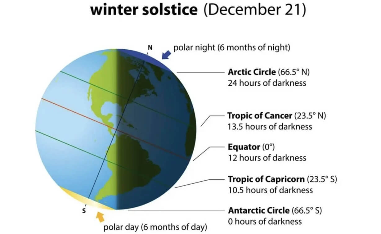
This causes a strong temperature difference between the polar and sub-tropical regions, and a large low-pressure (cyclonic) circulation starts to develop across the Northern Hemisphere. It extends from the surface layers high up into the atmosphere. This is known as the Polar Vortex.
Like in the lower levels, the process is the same higher up in the atmosphere, creating a large and powerful circulation as the temperatures drop. That is known as the Polar Vortex, a large-scale circulation across the atmosphere.
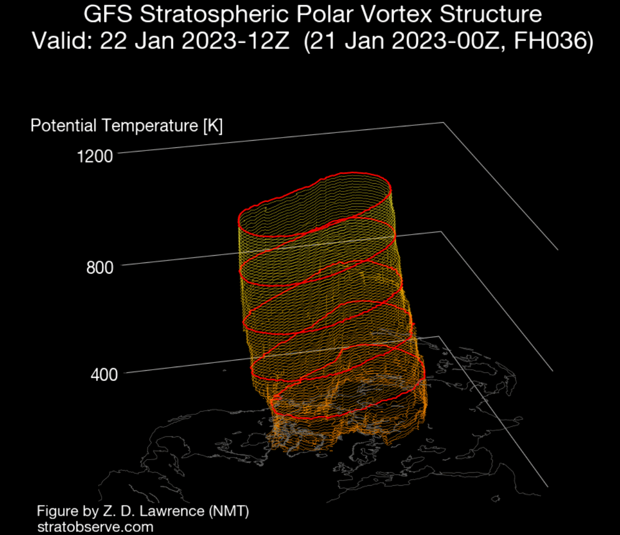
We produced a 3-dimensional image of the Winter Polar Vortex. The vertical axis is greatly enhanced for better visual presentation. You can see the actual structure of the Polar Vortex, connecting down to the lower levels to the pressure systems.
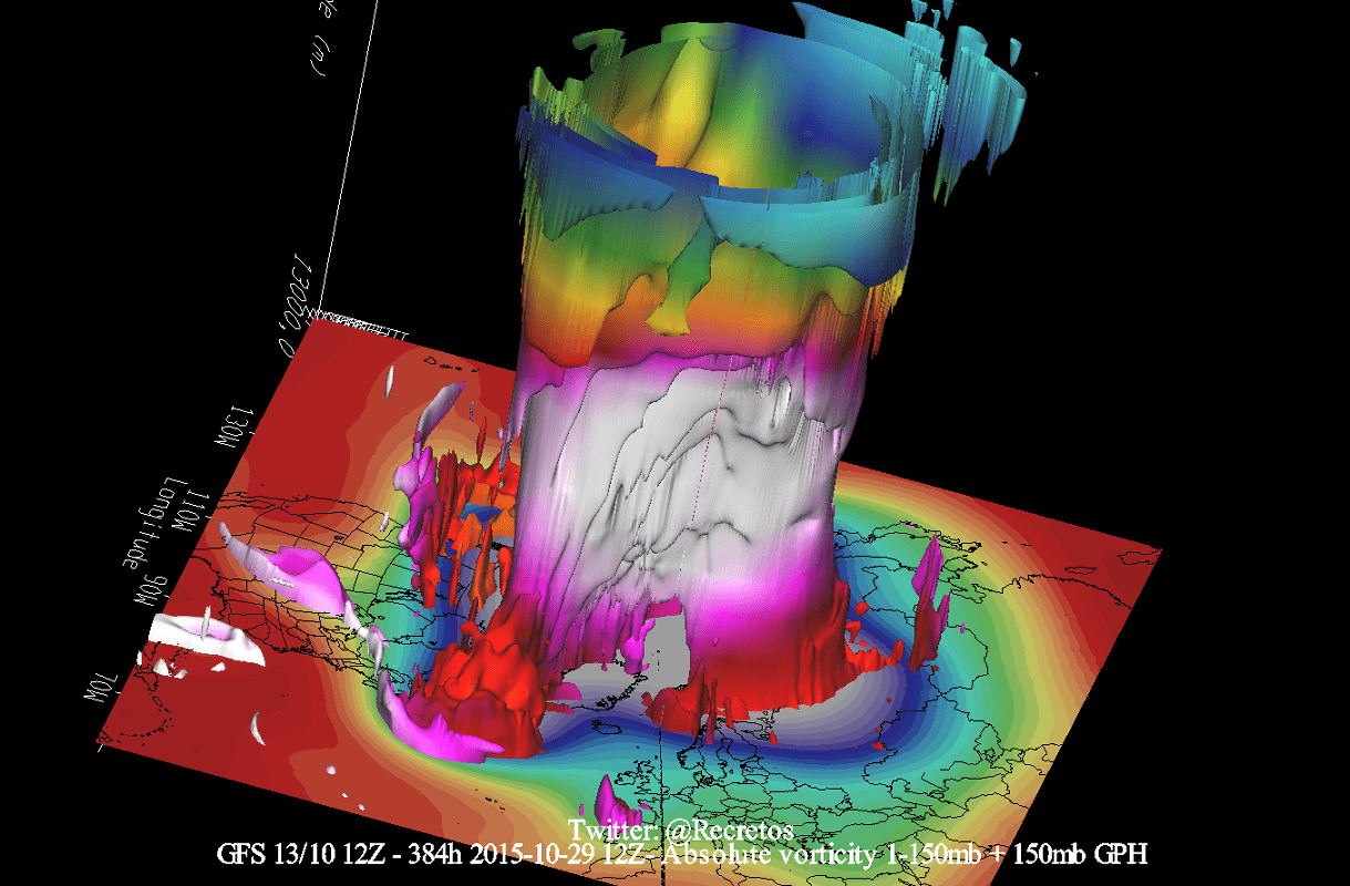
For this reason, we tend to separate the entire Polar Vortex into an upper (stratospheric) and a lower (tropospheric) part. They both play their role differently, so we monitor them separately. But it is also very important if they are properly connected. Image by NOAA-Climate.
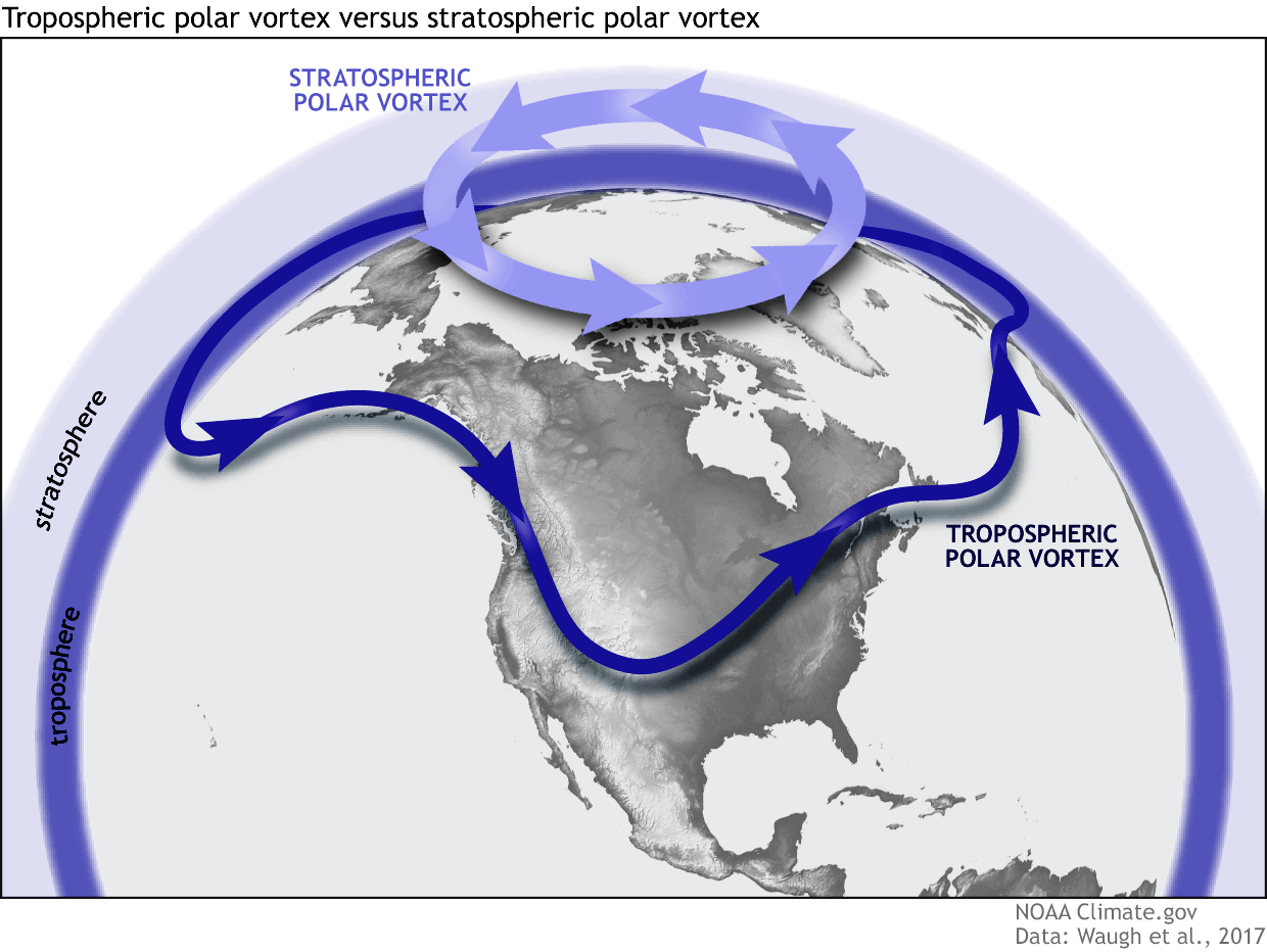
But, a very important thing to add: In this article and during Winter, when we mention the word Polar Vortex, we (in most cases) refer to the higher stratospheric part of the Polar Vortex. It is very dynamic and packs a lot of power, and its changes can have a long-lasting effect.
The upper (stratospheric) part is more circular and symmetrical as it spins higher above the ground. However, the lower structure of the Polar Vortex is much more uneven and mainly disrupted. That is due to the influence of the terrain/mountains and strong pressure systems acting as obstacles in the flow.
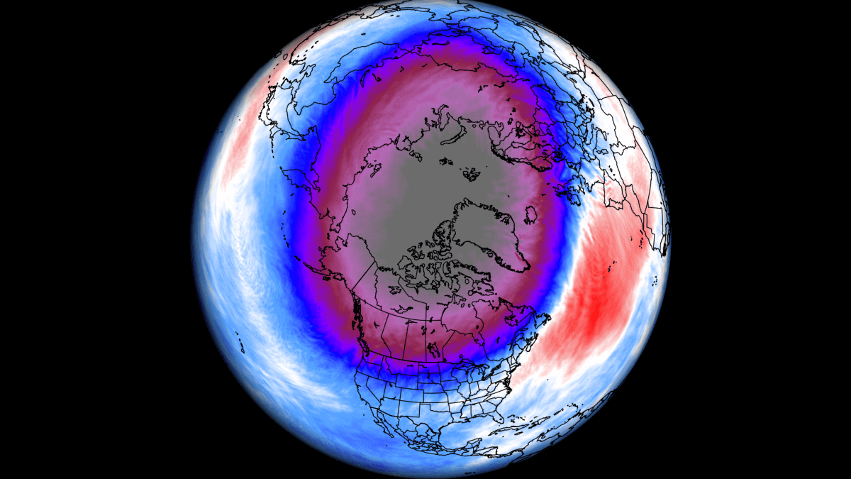
The image below shows the high-altitude Polar Vortex at around 30km/18.5miles in the middle Stratosphere during Winter. It is circular in shape, with the temperature dropping quickly towards its cold inner core.
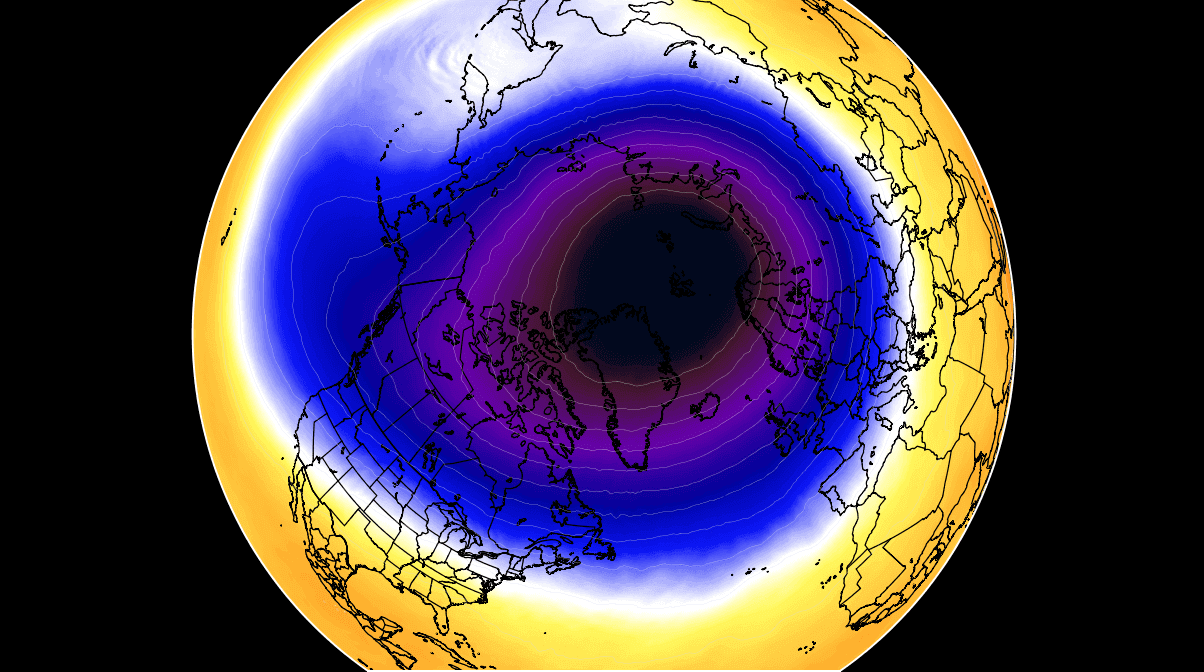
The stronger winds are typically found in the outer edge, called “the surf zone”. Winds are important when describing the Polar Vortex, as they are usually the first to show that something is changing.
In the following image below, we have the lower layers of the Polar Vortex at around 5km/3miles. The closer to the ground we go, the more deformed the Polar Vortex gets. That is because it has to interact with the terrain/mountains and strong pressure systems around the Hemisphere.
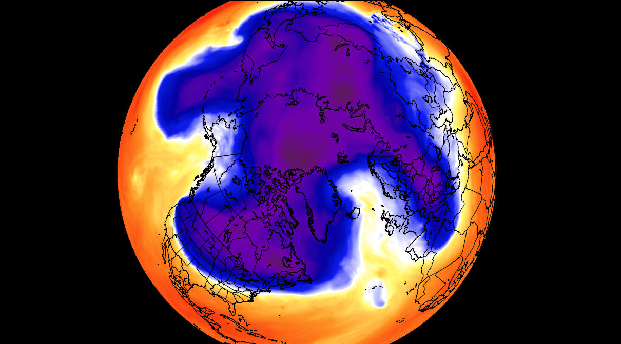
Notice the cold “arms” extending colder air and snowfall into the lower latitudes. These arms pack a lot of energy and can create strong winter storms and arctic outbreaks across the United States.
So, to summarize, the Polar Vortex behaves like a very large cyclone, covering the Northern Hemisphere from the North Pole down to lower latitudes. It is present through all atmospheric levels, from the ground up, but can have different shapes at different altitudes.
To put the Polar Vortex into perspective, we produced a high-resolution video below, showing the vortex spinning over the Northern Hemisphere in the Stratosphere at the 30mb level, around 23km/14miles altitude.
Notice how the stratospheric vortex covers a large part of the Northern Hemisphere. As it spins over the Northern Hemisphere, it is also connected to the lower levels, driving winter weather below.
The main takeaway from the video should be that the Polar Vortex is not just one winter storm or a cold outbreak that moves from the Midwest into the northeastern United States.
It is one large cyclonic area spinning over the entire Northern Hemisphere, from the ground up to the top of the Stratosphere and beyond, reaching over 50km/31miles altitude.
POLAR VORTEX WEATHER
So why is all this important? Why do we care about the Polar Vortex every Winter?
The answer is actually quite simple. This stratospheric polar circulation, called the Polar Vortex, can mean the difference between a very cold and snowy winter and a Warm and dry Winter.
A strong Polar Vortex usually means strong polar circulation. This usually locks the colder air into the Polar regions, creating milder conditions for most of the United States and Europe. In these conditions, the Winter can be mostly warmer than normal across the mid-latitudes.
In contrast, a weak Polar Vortex can create a weak jet stream pattern. The colder arctic air is harder to contain, which can now escape from the polar regions into the United States and/or Europe. Image by NOAA.
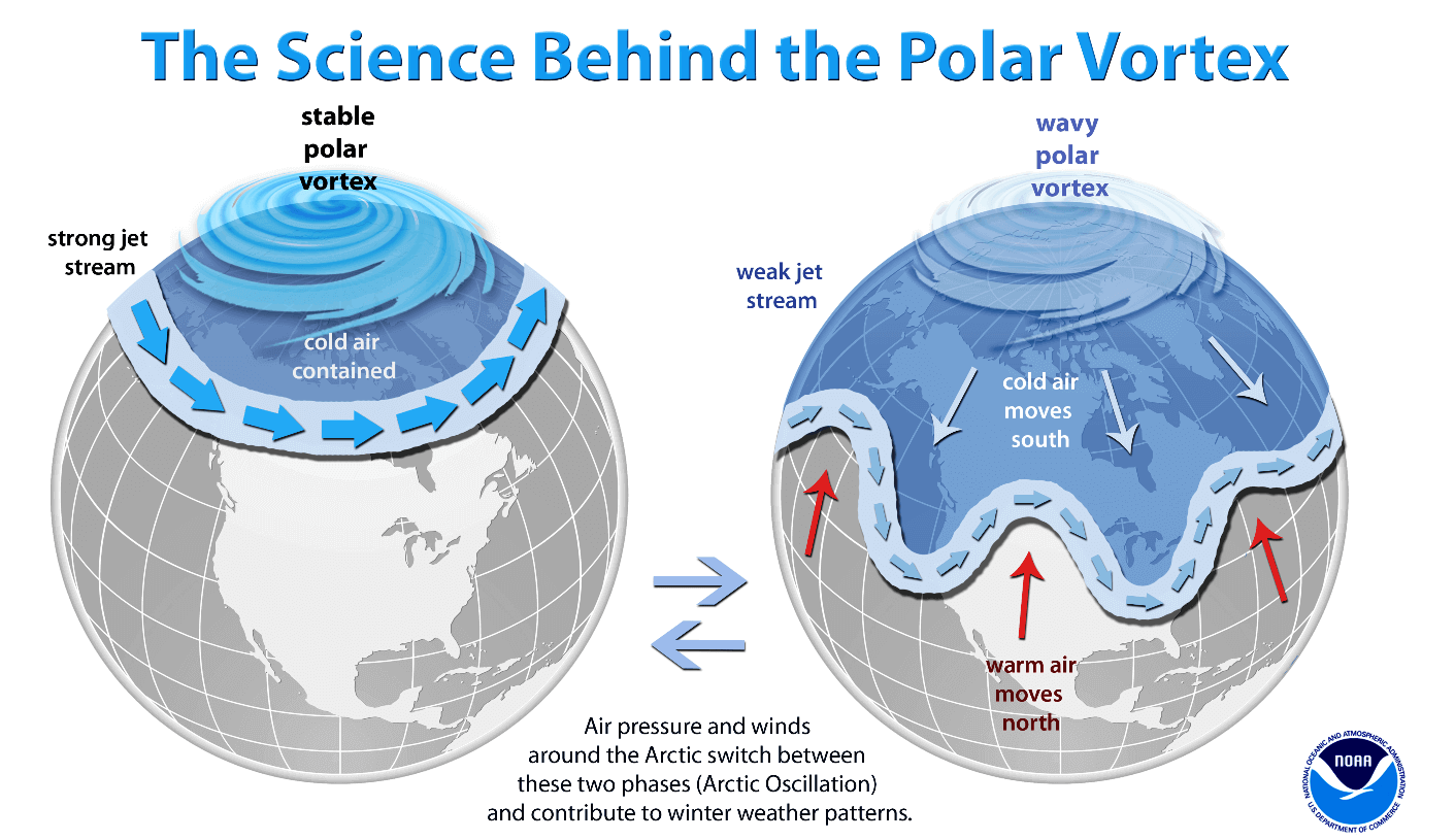
So, if you are a fan of a warmer Winter across the United States and Europe, you will prefer a strong Polar Vortex. But if you like proper Winter weather with cold and snow, a weak/disrupted Polar Vortex is your best bet.
As each year is different in the story of the Polar Vortex, we will look at the latest data in the Stratosphere and how a new Polar Vortex is starting to emerge for the 2023/2024 Winter season.
NEW SEASON, NEW POLAR VORTEX
The cooling over the North Pole has already begun. The cooling of the Stratosphere usually starts in August, increasing strongly over September and October. Finally, the Stratosphere reaches its coolest period in November and December, when the Polar Vortex is usually the strongest.
Below is the NASA analysis graph for temperature in the mid-stratosphere over the north pole. The blue line is last year, and the grey/white areas are historical data. The red square marks the month of September.
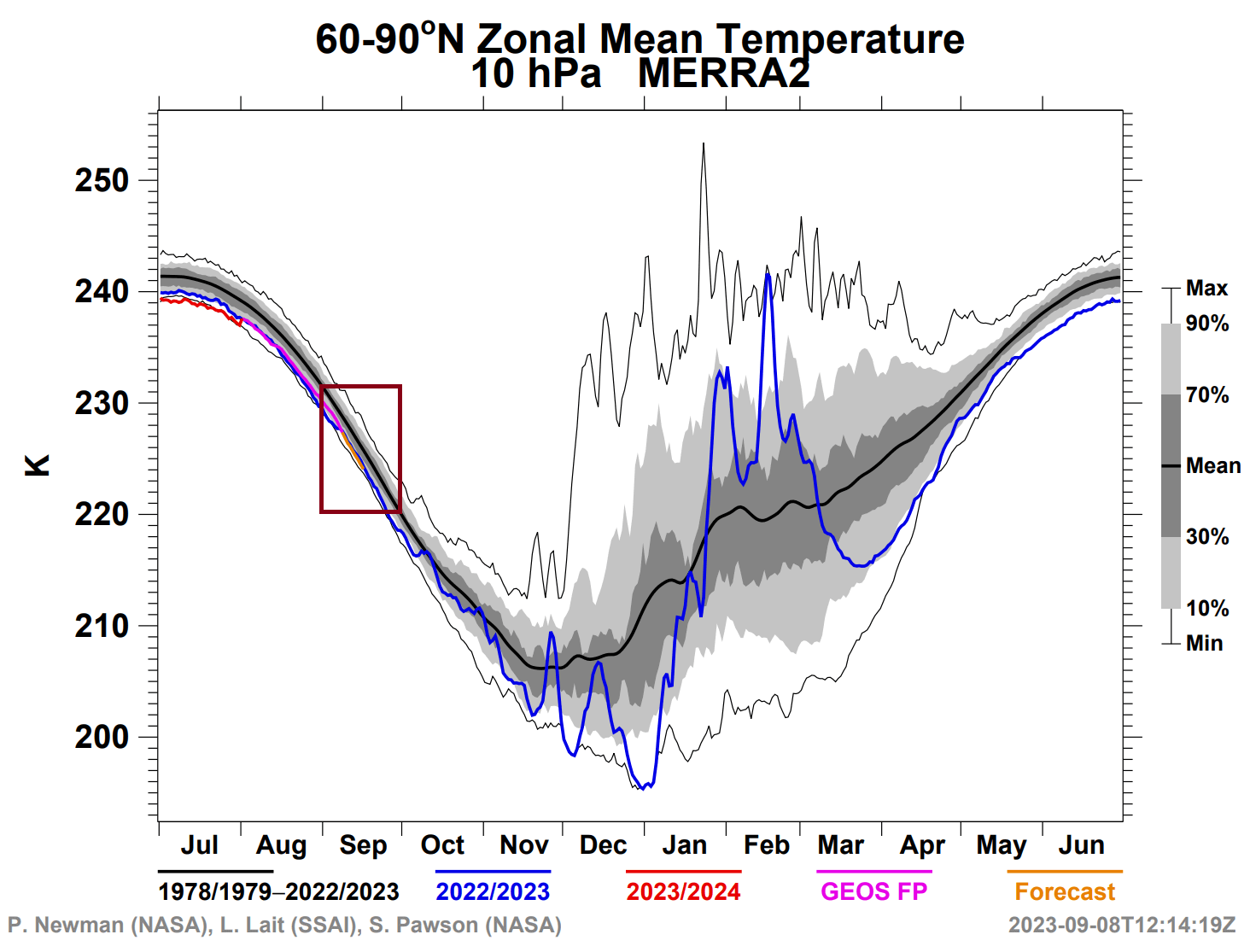
You can see the violet line, which is the latest analysis. It shows that the Polar Vortex is currently running colder than normal but at similar levels as last year.
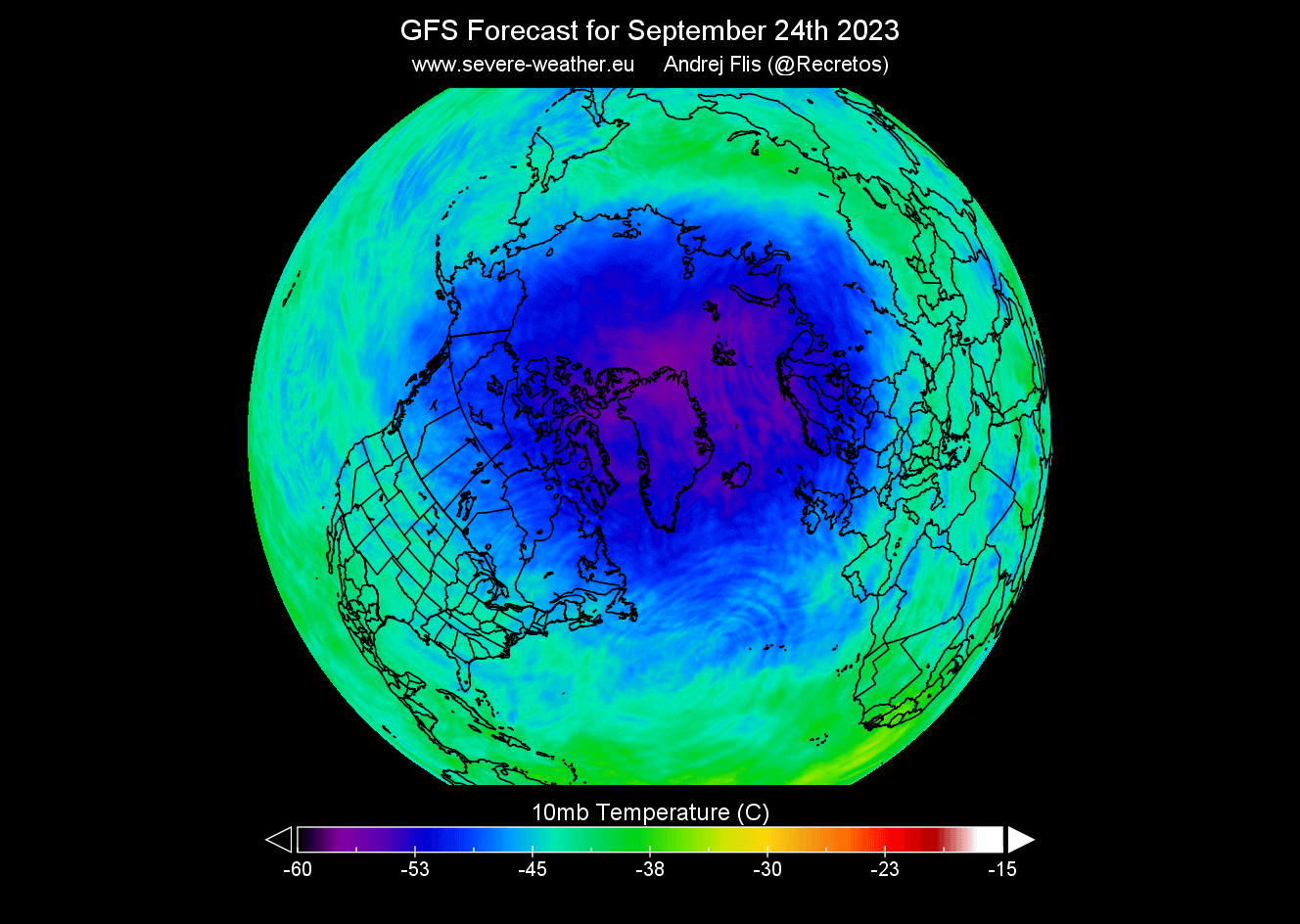
The temperature is dropping fast in the Stratosphere at around 30km/18.5miles altitude. In the image below, you can see the temperature change forecast for late September. It shows ongoing cooling over and around the North Pole, with a strong temperature drop in the next 16 days.
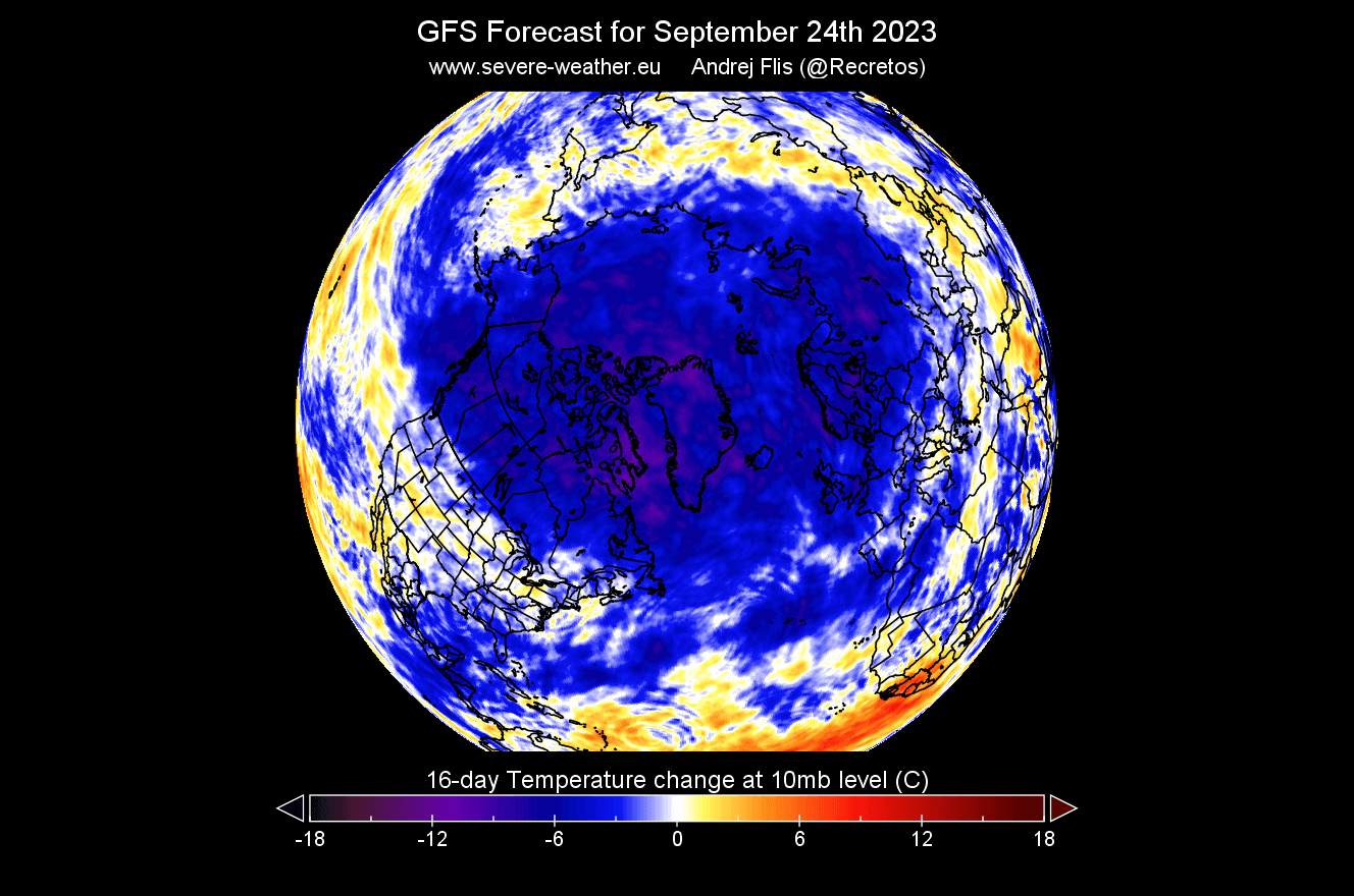
Looking at the actual temperature forecast, we can see a cold core developing over the polar circle. This is the heart of the Polar Vortex, and the colder it gets, the stronger the Polar Vortex can become. That is because it feeds off the temperature/pressure difference between the polar and the southern regions of the Northern Hemisphere.
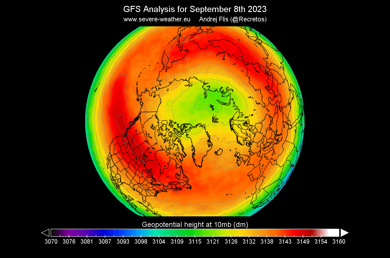
The pressure is also starting to drop rapidly. The image below shows the geopotential height of 10mb level (30km/18miles altitude). You can see a smaller low-pressure area that has already begun to develop over the Arctic Circle. That is the foundation for the Polar Vortex for the upcoming Winter 2023/2024.
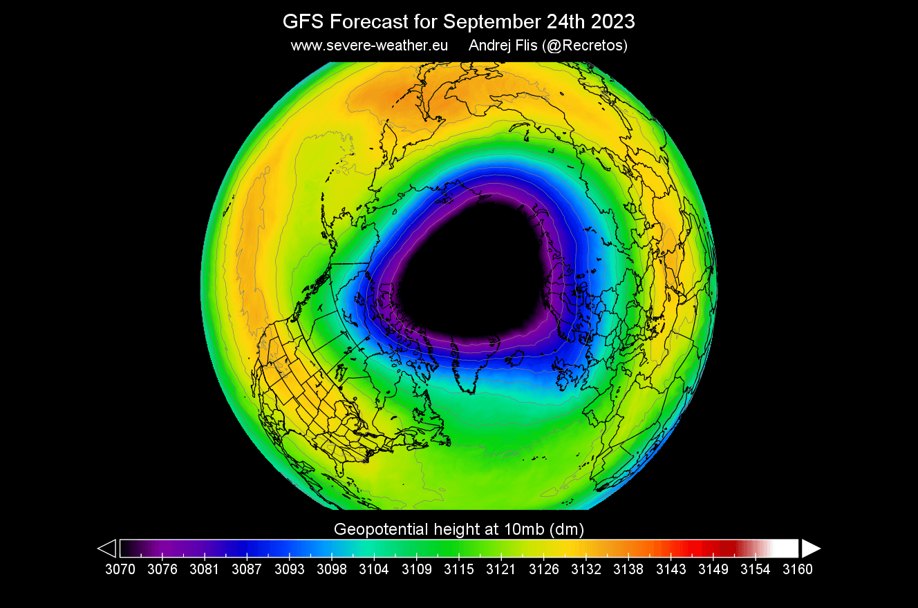
Looking at the forecast for late September, shown below, you can see the Polar Vortex is much more developed and rapidly increasing in size and influence. As the pressure drops in the Polar Vortex, it increases its wind speed and depth. The stronger it gets, the easier it can influence our weather down at the surface.
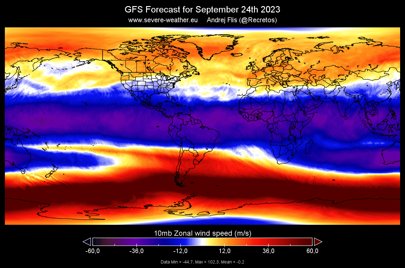
Speaking of wind, the current forecast shows the stratospheric jet stream developing. This is called the Polar Night Jet. The image below shows the stratospheric jet stream in the upper Stratosphere at 1mb level (~45km/28miles altitude).
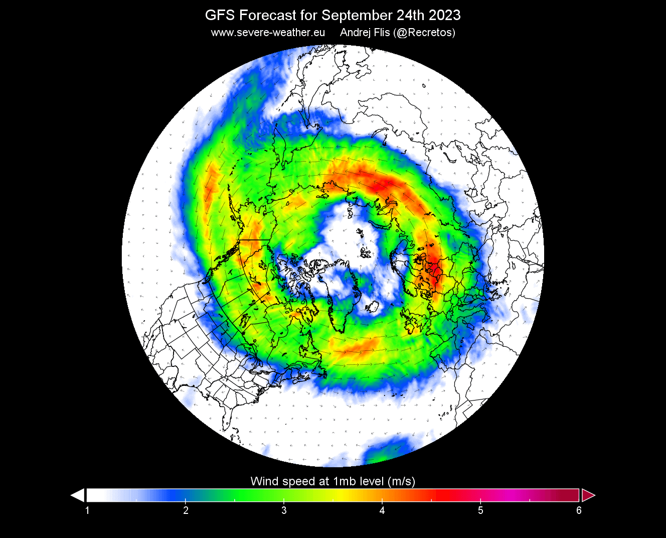
Stratospheric winds don’t have any special importance in September. But it shows how the stratospheric Polar Vortex is starting to rapidly organize into a proper circular formation, increasing its speed and influence from here onwards.
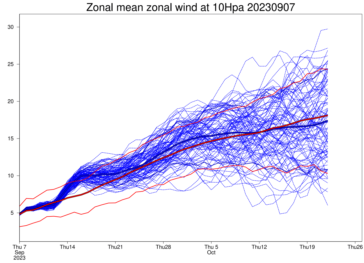
STRATOSPHERIC WIND FORECAST
The strength of the stratospheric jet stream at the 10mb level is usually used to determine the strength of the Polar Vortex and its potential influence on the weather. This is especially the case during the mid-winter when it is usually at its strongest.
Compared to the long-term average, current forecasts show that the strength of the Polar Vortex is likely to be around average in late September and into early October.
That is seen in the image below, which shows the ECMWF forecast of the stratospheric Polar Vortex winds at 10mb (~30km/18.5miles). Red lines denote the average values. This might not mean much for now, but it shows how the Polar Vortex starts its new season, and sometimes there can be early anomalies.
Lower down towards the surface, we can still see these winds, called the jet stream. The image below shows the wind speed forecast for late September at around 5km (3 miles) altitude.
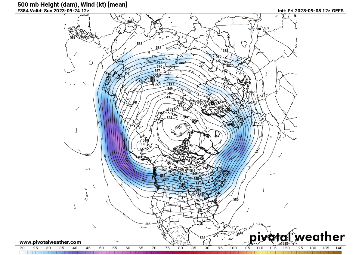
Like in the Stratosphere, lower down, we still see the polar circulation (the jet stream) edging the Polar Vortex in the lower levels. Again, this shows that the overall weather circulation is connected on many levels and into a large single system.
The 3-dimensional polar vortex forecast shows a good structure appearing higher in the Stratosphere in late September. However, you can see that it is not connected down yet, as the structure is just building while the Northern Hemisphere is cooling further.
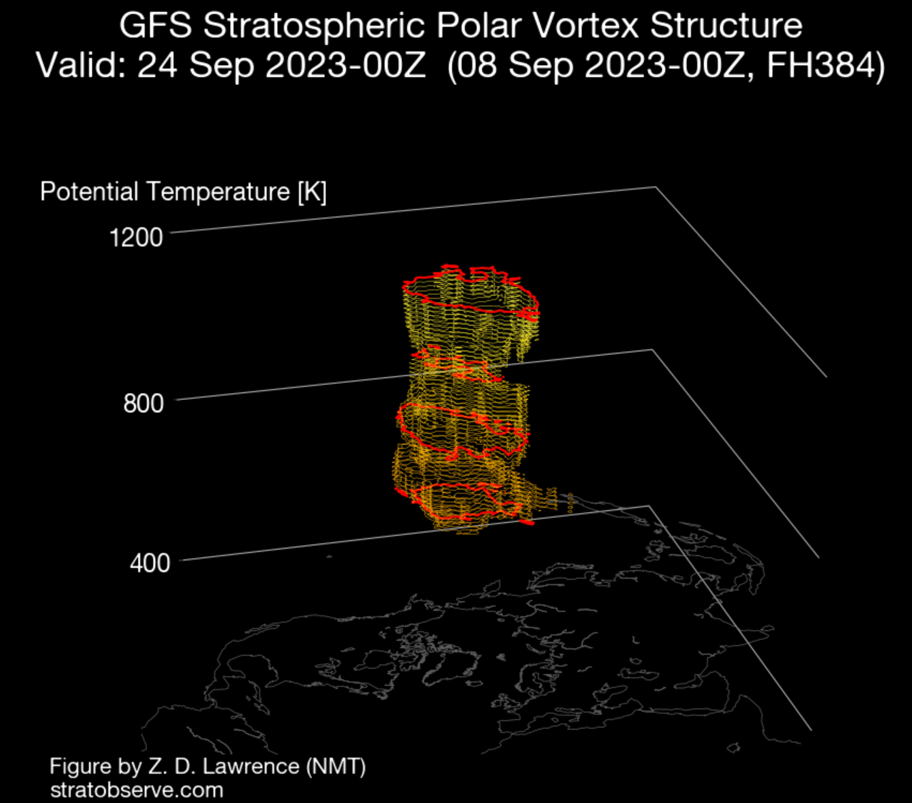
But we can compare this 3D forecast with the data from January to compare how the Polar Vortex looks in mid-winter. You can see that it is much larger and present at all levels in mid-winter. This just shows that the Polar Vortex has much growing to do, but with that also comes great power.
Now we know what the Polar Vortex is and how it works. But why do we care about it? As you will now see, the Polar Vortex has the power to do many things regarding weather, especially during Winter when it is strongest.
But first, let’s talk about what might be different for the Polar Vortex this Winter season. A strong stratospheric wind anomaly is ongoing over the Equator, and it will play a role with the Polar Vortex in the upcoming Winter.
It is called the Quasi-Biennial Oscillation (QBO), also known as the “heartbeat of the Atmosphere,” as it is so regular.
ATMOSPHERIC HEARTBEAT
The Quasi-Biennial Oscillation (QBO) is a regular variation of the winds high above the Equator. Strong winds in the Stratosphere travel in a belt around the planet, and around every 14 months, these winds completely change direction.
This means that winds high above the equator change from west to east every year or so.
A wind analysis below for the 10mb level (30km/18.5miles) shows a negative wind stream above the tropical regions. The negative values mean that easterly winds are prevalent. This means that the QBO is in the east (negative) mode.
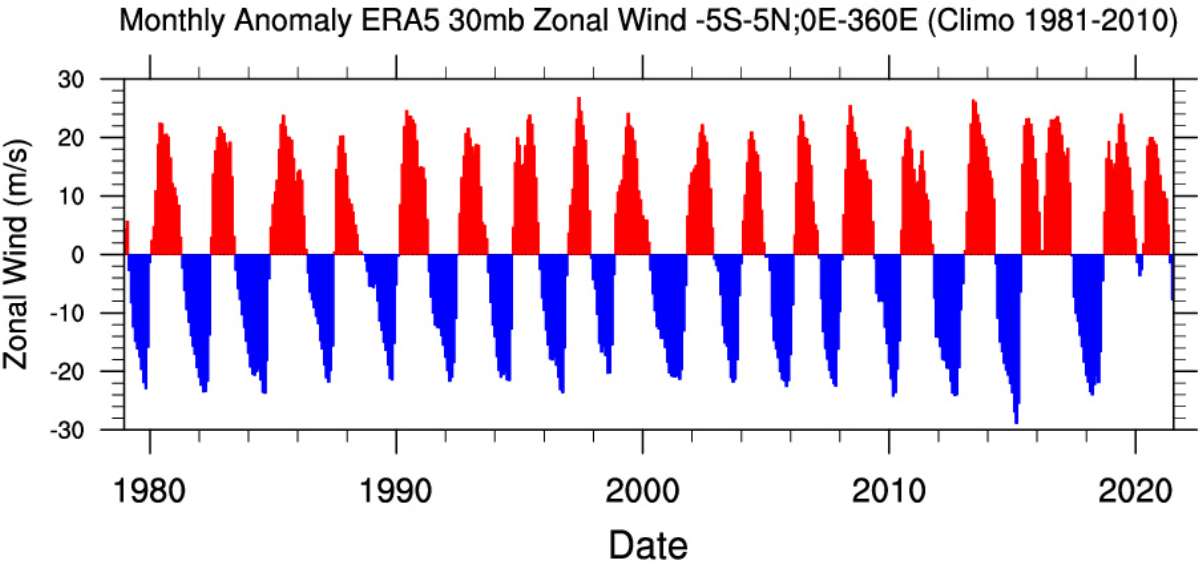
Below is a special graph showing the zonal wind anomalies for the past 40 years at around 24km/15mi altitude over the Equator. It shows just how regularly this wind shift really is, like watching a heartbeat, but in this case, an atmospheric one.
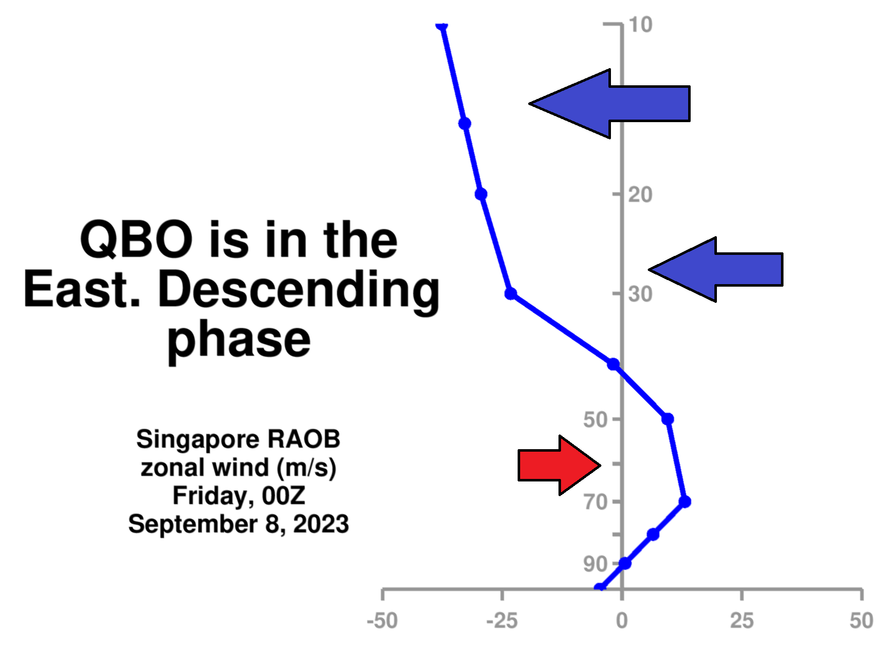
A radiosonde analysis from Singapore also shows the wind direction above the tropical regions. It reveals the easterly winds around the 10-40mb level, confirming the east QBO phase is descending in the Stratosphere and will be dominant this Winter.
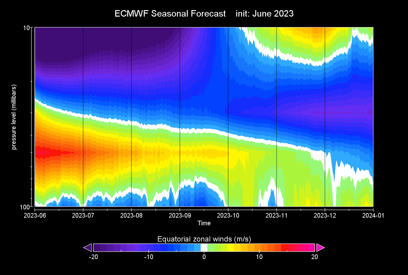
Looking at the ECMWF seasonal forecast data below, you can see the negative QBO. Notice the east QBO descending further down as we enter Fall and Winter. This forecast confirms that a mature negative QBO phase will be in place for the 2023/24 Winter season.
So, if we summarize, the QBO is the wind phase in the tropical Stratosphere, pulsing between the easterly and westerly phases. That is all well and good, but how do these phases actually influence the winter weather?
QBO AND WINTER POLAR VORTEX
The QBO is an important part of weather development in Winter, as it can affect the Polar Vortex and the jet stream. The power and direction of the winds in the polar jet stream can change with the QBO.
Depending on the QBO, the risk of winter conditions across the Northern Hemisphere can differ by each of the phases:
- When the QBO is negative (easterly), there is an increased chance of a weaker jet stream, sudden stratospheric warming events, and colder winters in the United States, Canada, and Europe.
- When the QBO is positive (westerly), the chance increases for a stronger jet stream and a stronger Polar Vortex. That means a milder winter, as the colder air is locked in the polar regions, having a harder time punching out of the strong circulation.
Looking at winter pressure anomalies during a negative QBO, you can see a tendency for lower pressure in the southern and eastern United States and Europe. Higher pressure is present over Canada and the Pacific Northwest.
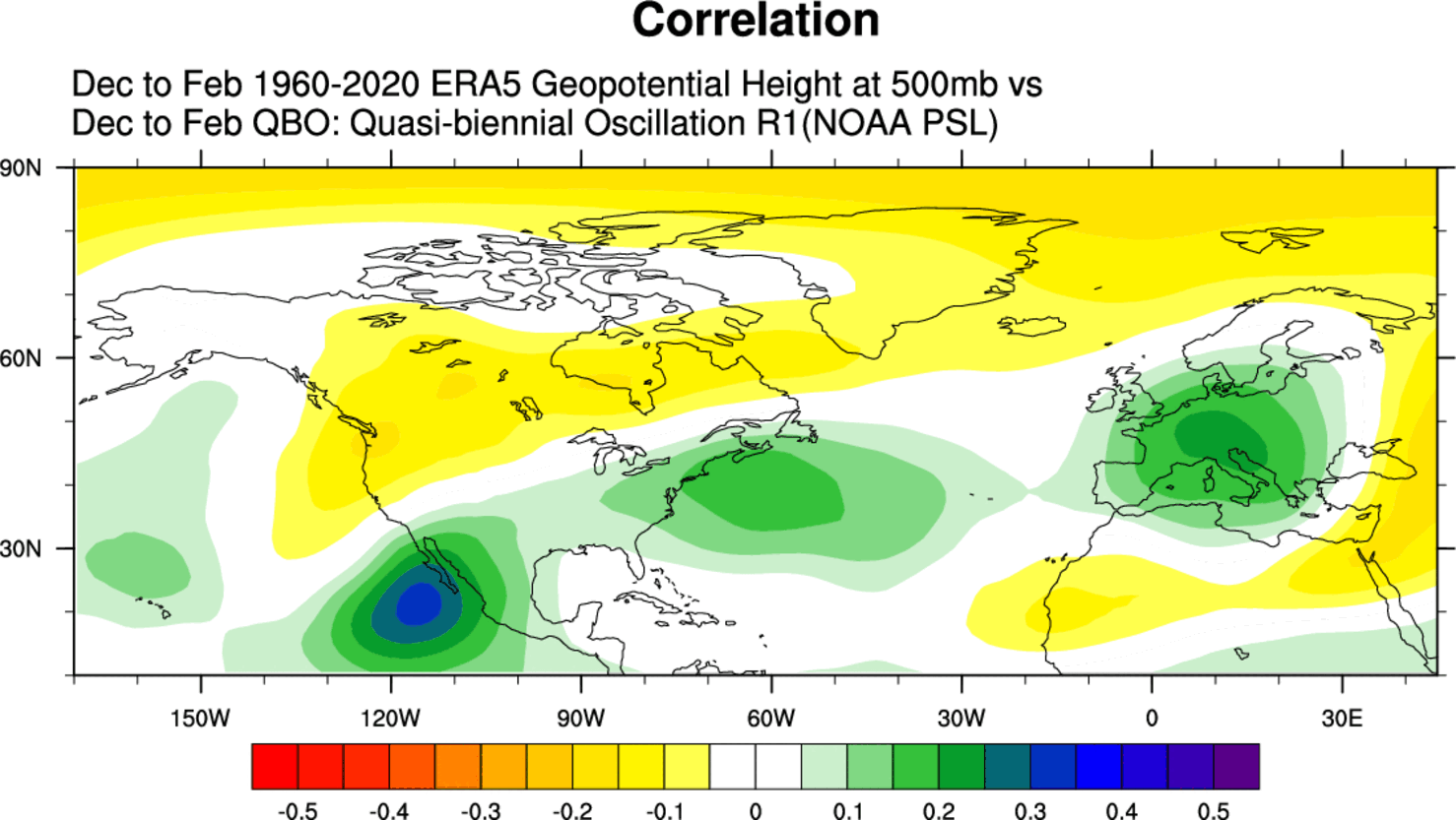
This shows a tendency for a negative NAO pattern in the Atlantic and a more disrupted (wavey) jet stream. A disrupted jet stream means an easier way for the colder air to escape the polar regions and into the United States.
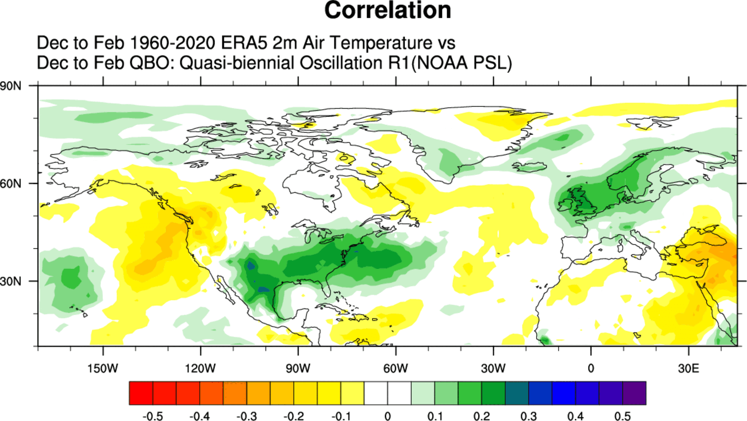
Below, you can see a tendency for colder temperatures over the southern and eastern United States and Europe in a negative QBO. The signal is not overly strong, as there are a lot of other “winter influencers” besides the QBO and Polar Vortex, but it is present.
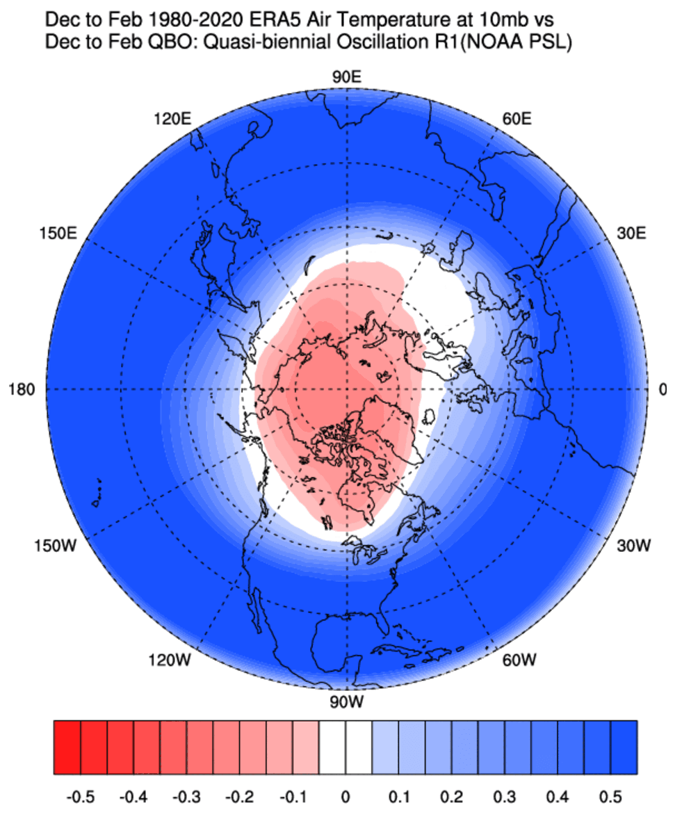
The Polar Vortex is one of the ways that the QBO can help to shape the Winter weather patterns. The next images show the connection between the east QBO and the stratospheric Polar Vortex in the December-January winter period.
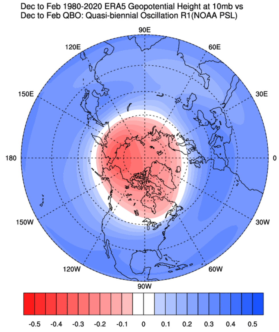
In the image below, you can see a signal for higher pressure in the polar Stratosphere, which indicates that in an easterly QBO, the Polar Vortex and the stratospheric winter circulation are weaker.
That is usually associated with Sudden Stratospheric Warming (SSW) events. These powerful weather events occur high up in the Polar Stratosphere, raising the temperature and pressure. These effects usually come crashing down, impacting the weather across the Northern Hemisphere.
That can also be seen in the stratospheric temperature correlation. It indicates warmer stratospheric temperatures in an easterly (negative) QBO phase over the polar regions in the Stratosphere. Effectively, it indicates a higher SSW chance.
A proper Polar Vortex collapse event (Sudden Stratospheric Warming) means a strong temperature and pressure rise in the Stratosphere and a resulting collapse of the Polar Vortex circulation.
There is one major condition for a disruption event to be classified as a Sudden Stratospheric Warming event or a full collapse. The stratospheric winds, which are mostly westerly in Winter, must be reversed to easterly.
SUDDEN STRATOSPHERIC WARMING EVENT
Typically, a Polar Vortex weakens due to a rise in temperature and pressure in the Stratosphere. That is called a Sudden Stratospheric Warming (SSW) event, which can collapse the Polar Vortex.
Simplified, a Sudden Stratospheric Warming event (SSW) is exactly what the name suggests. It is a sudden temperature rise in the polar Stratosphere during Winter. Warming of the Stratosphere means that the Polar Vortex is weakened and can collapse under pressure from the warming event.
This creates a chain reaction, disrupting the jet stream, creating high pressure over the Arctic Circle, and releasing the cold Arctic air into Europe and the United States.
An SSW event is usually triggered by specific pressure patterns in the lower levels that can send a lot of energy upwards vertically into the Stratosphere. The image below shows an example of a typical SSW event and how it progresses over a 30-day period.
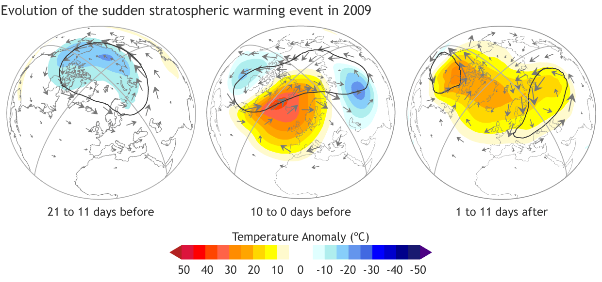
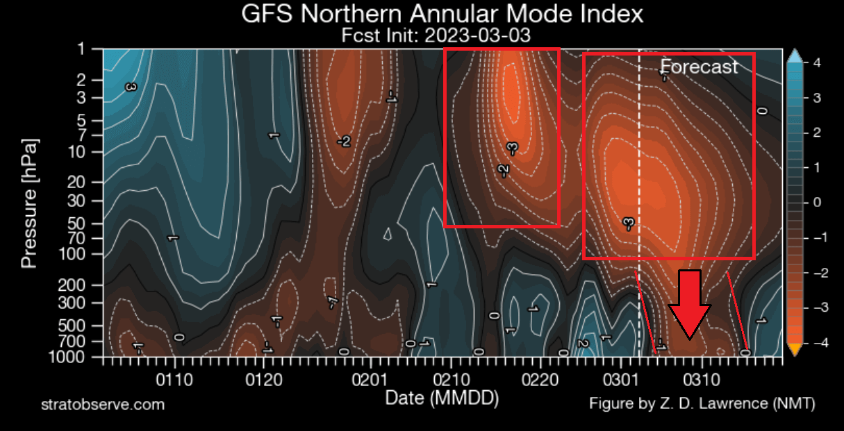
Such an event occurred in February this year. A strong warming wave took over the polar Stratosphere and the Polar Vortex. With the pressure rising in the Stratosphere and winds reversing, it was marked as a proper SSW event.
Looking at the first day of the SSW event below, you can see a large warming wave in the top and mid-stratosphere. It spread over the polar regions. Combined with a stratospheric high (H) covering the North Pacific and western Arctic, it has pushed and displaced the Polar Vortex (L) out of the North Pole.
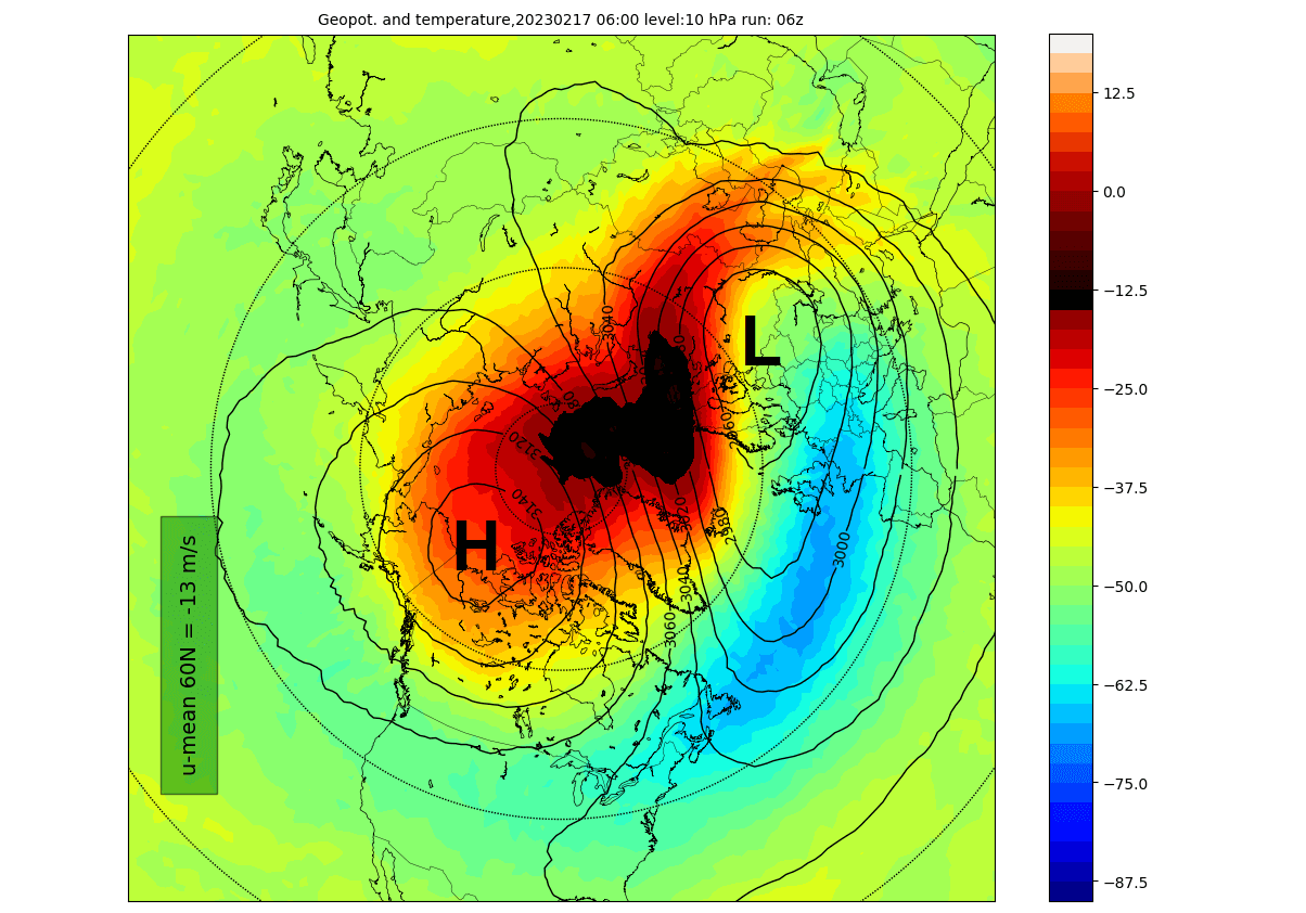
You can see the compressed Polar Vortex over Siberia. This is because a strong stratospheric high-pressure area (H) has taken over the Polar Regions and severely disrupted the atmospheric circulation in the higher and middle latitudes.
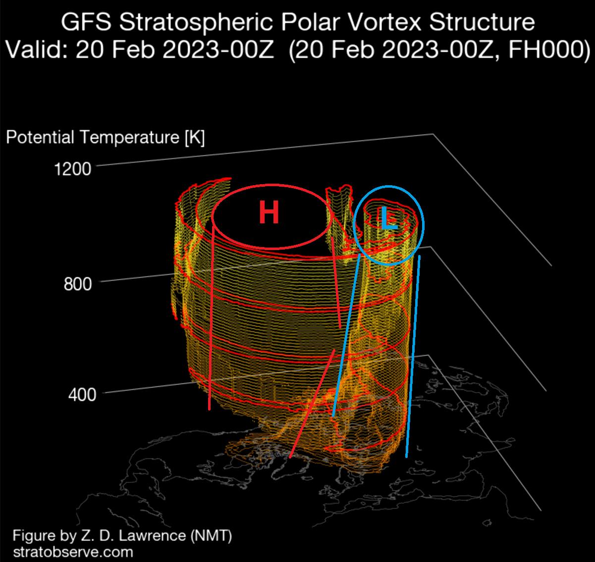
The disruption happened on a large scale and extended over much of the Stratosphere. Even tho the disruption was strong, it still takes time for actual weather effects to filter into the lower layers.
In the Stratosphere, you can see high-pressure anomalies from the Stratosphere connecting down to the lower levels. Again, this directly connects with the Stratospheric warming events, and the pressure patterns have responded with a strong blocked pattern.
The resulting pressure pattern below was fully established two weeks after the initial SSW event. The main result was a strong blocking high over Greenland, with the displaced low-pressure systems from the United States over the North Atlantic into Northern Europe.
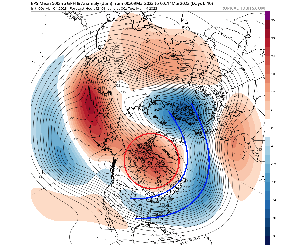
This pressure pattern is a typical weak vortex event. And as we showed in the intro, it means an easier escape of cold air down into the lower latitudes.
Looking at the temperature anomalies for that time, you can see a strong cold outbreak across the United States. The Greenland blocking system helps to push the cold air out of the polar regions, so a stratospheric warming event makes these scenarios much more likely in Winter.
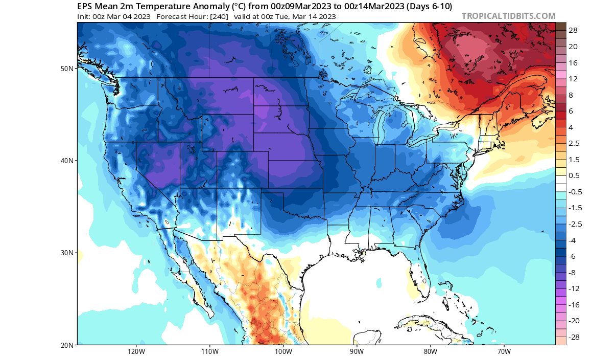
There was no real cold air outbreak in Europe on a large scale, which also shows that a stratospheric warming event cannot always impact all regions with cold weather.
POLAR VORTEX AND WINTER 2023/2024
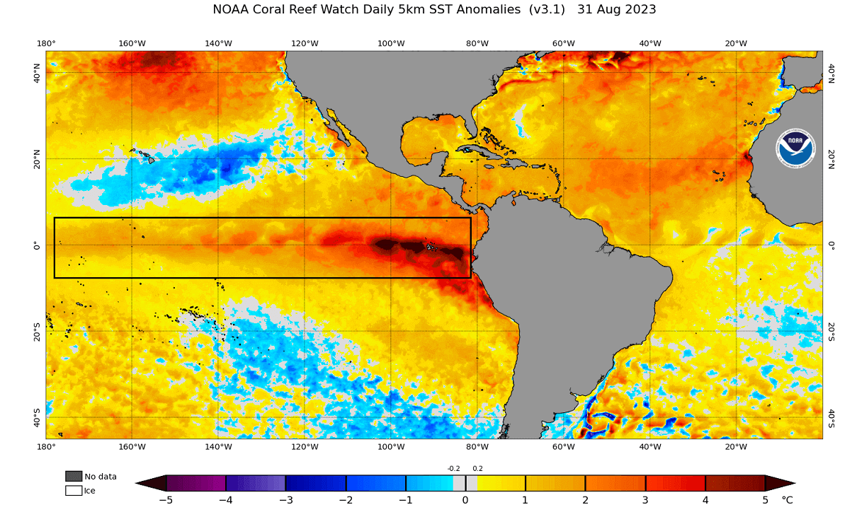
One of the most important global factors for the upcoming Winter season is the El Niño event. This is a warm ocean anomaly in the tropical Pacific Ocean. And being in that region, it is also linked to the QBO anomaly directly in the Stratosphere above it.
We have discussed the El Niño phase of the ENSO and its influence in our first Winter forecast, so check it out for more details on the El Niño and the ENSO cycle.
To keep it simple, El Niño is what we call the warm/positive ocean anomalies in the tropical Pacific Ocean. It forms under certain conditions and can change the weather globally on a seasonal scale.
You can see the El Niño in the image below. We know what effect El Niño might have on global circulation, and thus, we can anticipate what it might mean for the Polar Vortex.
Historically, an ENSO phase can increase the chances of a Polar Vortex disruption event occurring. The image below shows the typical Sudden Stratospheric Warming (SSW) event frequency by month and by the ENSO event.
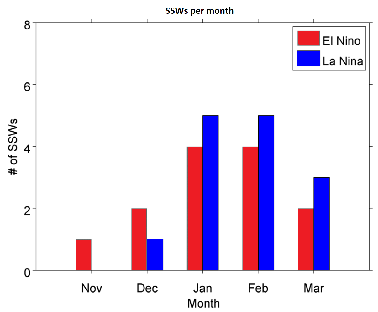
As you can see, an El Niño phase has a higher chance of producing a Polar Vortex collapse event in the early parts of Winter. With the typical major SSW events occurring in December/January, we can look for January 2024 for any potential SSW and Polar Vortex collapse events.
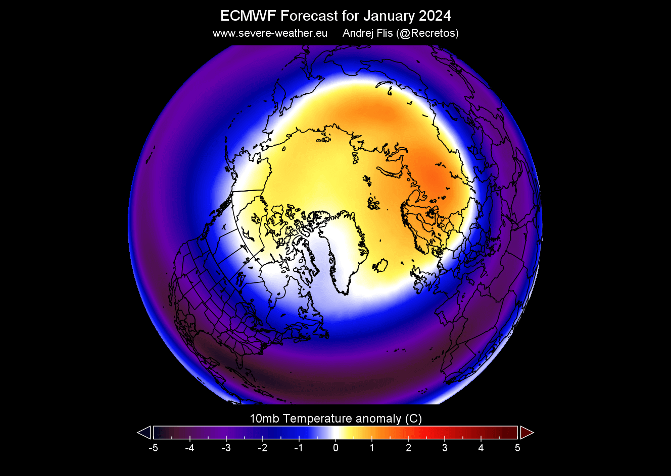
Below is the EMCWF stratospheric temperature anomaly forecast for the 30km/18.5miles altitude. You can see that the ECMWF is actually forecasting a warmer polar region, which indicates a potentially weaker Polar Vortex.
We cannot forecast an SSW this far out into the future. But we can look at trends, emerging signals, and overall global configuration.
It gives us a signal to keep an eye on, as these dynamics can have a large-scale and long-lasting impact on the weather pattern during Winter.
So, how does an average Stratospheric Warming event influence the weather patterns?
WINTER WEATHER IN A POLAR VORTEX COLLAPSE
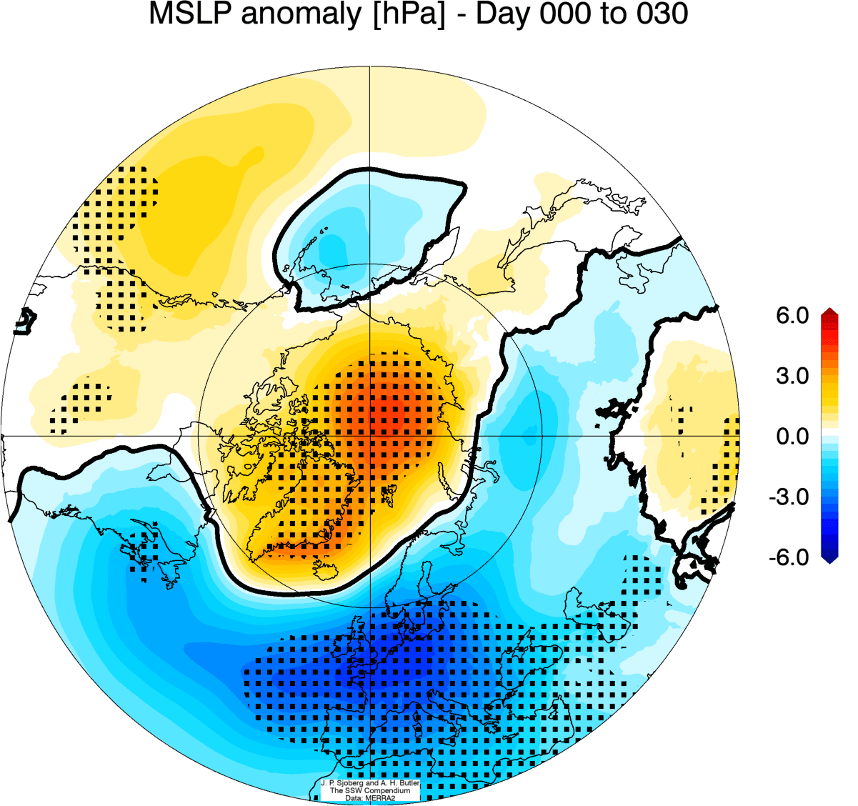
Below is the average surface pressure anomaly 0-30 days after a stratospheric warming event. You can see a typical blocked pattern with high pressure over the polar regions. This heavily disrupted circulation pattern helps to create a free path for colder polar air to move out of the polar regions.
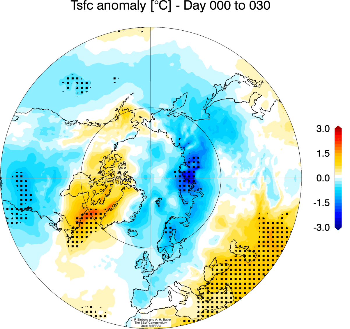
The corresponding average temperature 0-30 days after an SSW event shows that most of the United States and Europe is trending colder than normal. But remember: This is an average picture of many SSW events. Each stratospheric warming event is different and does not automatically mean a strong winter pattern.
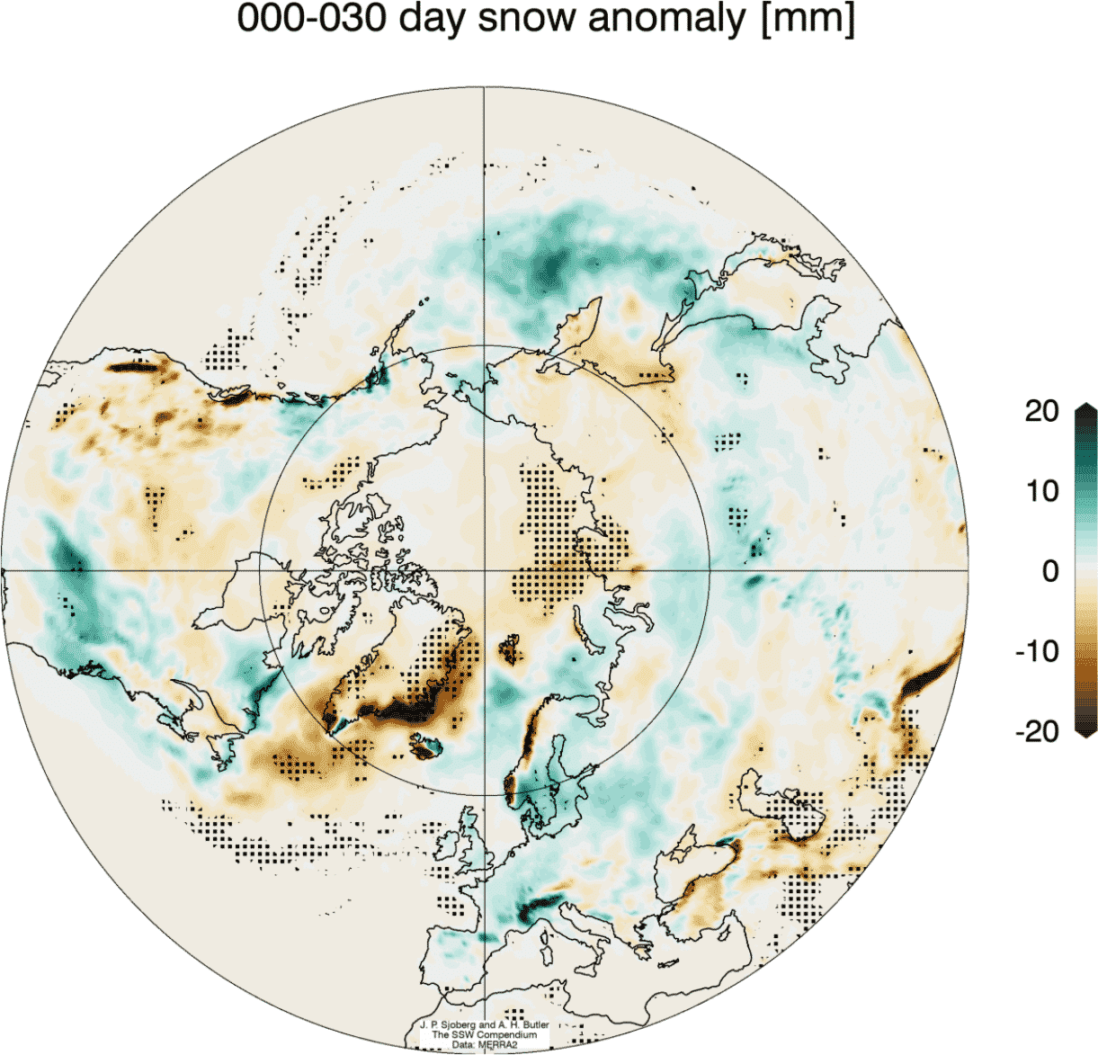
Looking at snowfall, we can see above-average snowfall over much of the eastern United States and Europe. This is an expected response, as seen after major stratospheric warming events. The colder air has an easier path towards the south, creating better snowfall opportunities.
So, as you can see, having a strong or weak Polar Vortex can significantly change Winter weather in the United States, Canada, and Europe. But, the Polar Vortex is not a simple entity to forecast, as it depends on many small and large-scale factors.
We will keep you updated on the global weather pattern development for the coming seasons, so make sure to bookmark our page. Also, if you have seen this article in the Google App (Discover) feed, click the like button (♥) there to see more of our forecasts and our latest articles on weather and nature in general.
Don’t miss: