September started with significant activity in the North Atlantic storm season. Storm Lee and Margot are active; Lee became the strongest Atlantic system of the year; it was a Category 5 storm last weekend. Storm Margot is next in the line and is forecast to turn towards Europe, precisely Ireland and the UK, for potential impact next week.
This year, the record-high average Atlantic Ocean sea surface temperature results in intense storms; one Category 5 (Lee) and two Category 4 systems have already been observed, Franklin and Idalia. The next in line, Margot, is a Category 1 storm, the 14th system of the Atlantic season in 2023.
Storm Margot is forecast to wobble in the central North Atlantic for another few days, then take a sharp east turn and head towards western Europe. Ireland, the UK, or France could be in its path with significant winds, swell, and torrential rainfall early next week.
The recent high activity comes after months of unusually warm, record-breaking water temperatures in the Atlantic Basin region.
Note that warmer sea waters lead to the highest potential for more tropical systems, including their intensity, during the Atlantic Storm Season, which lasts from June through November.
The extremely warm waters across the Atlantic Basin also increase the chances for tropical storms to reach the European continent. And next week is forecast to be the first impact of this autumn season.
THE HOTTEST-THAN-EVER AVERAGE TEMPERATURE MEASURED OVER THE NORTH ATLANTIC BASIN
During the month of July this year, temperatures at the North Atlantic Ocean surface reached the highest-ever levels in the history of measurements. In the final days of July, the daily average temperature of the whole Atlantic Basin was an astonishing 24.9 degrees Celsius (76.8 °F).
As of mid-September, ocean water temperatures are still extremely high across the central and western Atlantic, from 30 to 32 °C across the western Atlantic Basin, including the Caribbean and the Gulf of Mexico. Water temperatures closer to the European continent are from 26 °C around the Azores to 18 degrees C near Ireland and southwest England.
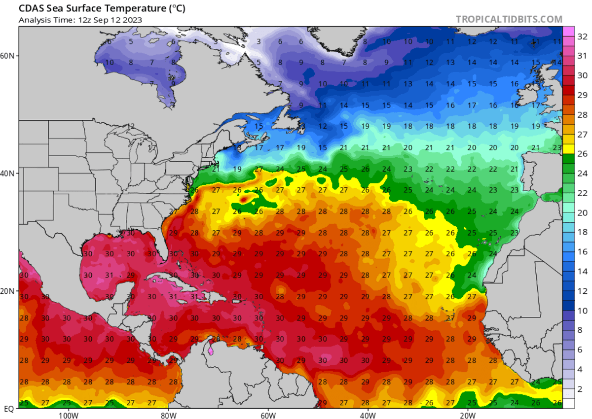
Normally, sea temperatures reach their peak values at the end of the summer season. The sea surface temperature in the Atlantic Ocean continues to rise in August towards its usual highest values observed in mid-September every year.
The previous record was set last year, in September 2022. So, around the usual statistic peak.
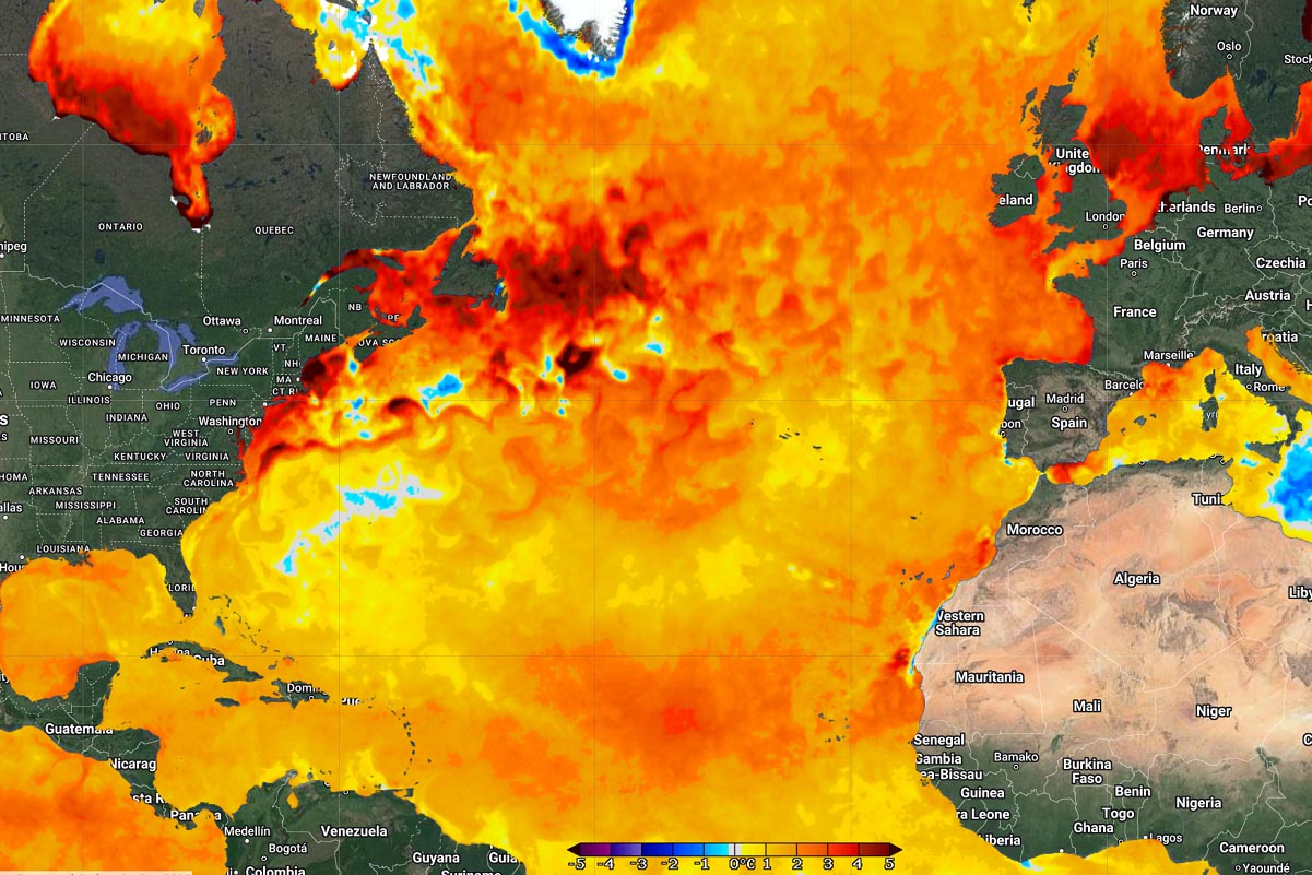
These so-called marine heatwaves are becoming more frequent and intense in recent years, and they are more persistent and spread over large areas this year. The 24.9 °C mark in July was more than one degree warmer than a 30-year climatological normal, calculated from 1982 to 2011.
The tropical central and western Atlantic regions remain well above normal as we grazed into the first month of meteorological autumn 2023. The Atlantic Basin is also anomalously warm around Europe; there are currently no areas with below-normal water temperatures.
The near-term SST anomaly forecast also hints temperatures will continue to rise in the main storm development region.

Weather model consensus reveals that these sea waters of the North Atlantic will be sufficiently warm enough to support significant tropical development during the peak of the storm season from mid-September into October. And also support their tracks towards the European continent.
Aside note: We closely monitor Western Africa’s weather conditions during the summer. This is where the tropical waves emerge into the eastern Atlantic Ocean. Plenty of waves are ongoing right now, moving west into the Atlantic.
Data shows that nearly 85% of these waves lead to organized deep convection over the warmer oceans, become depressions, and later get upgraded into storms.
ATLANTIC STORM SEASON 2023 FORECAST
The 2023 Atlantic storm season started on June 1st, and after late August, the activity started increasing, with multiple storms developing as we reached September. The usual peak follows in the following weeks and throughout most of October.
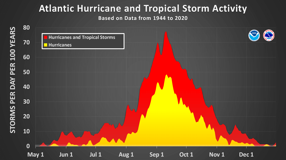
There was already one Category 5 storm that was Lee last week. There were also two Category 4 and one Category 1, making the total count of 14 storms in 2023. This year, the ongoing strong El Nino influence is forecast to bring lesser activity due to stronger wind shear in the tropical region.
However, the unusually warm and hottest-than-ever sea waters of the North Atlantic have resulted in increased activity. Mainly in terms of the cyclones’ more rapid strengthening and peak intensity. Numerous research studies have found that the warmer the waters are, the higher the potential for more intense systems.
The seasonal forecasts from the Colorado State University (CSU), led by Dr. Phil Klotzbach, hint at 18 named tropical systems, with nine Category 1+ and four major storms forecast for the Atlantic storm season 2023. That’s well above the 30-year average. Based on the long-term average, one season normally brings 14 named storms, seven of Category 1 or higher, where three reach a major intensity (Category 3 or greater).
So, in 2023, we are already past the long-term average, a month and a half before the official end of the season.
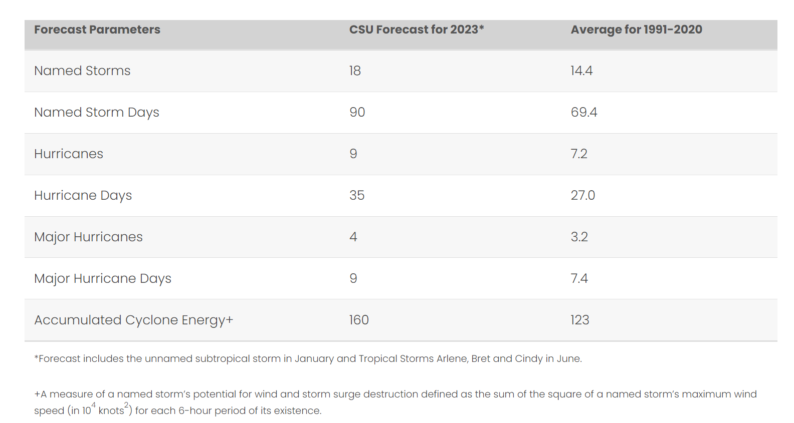
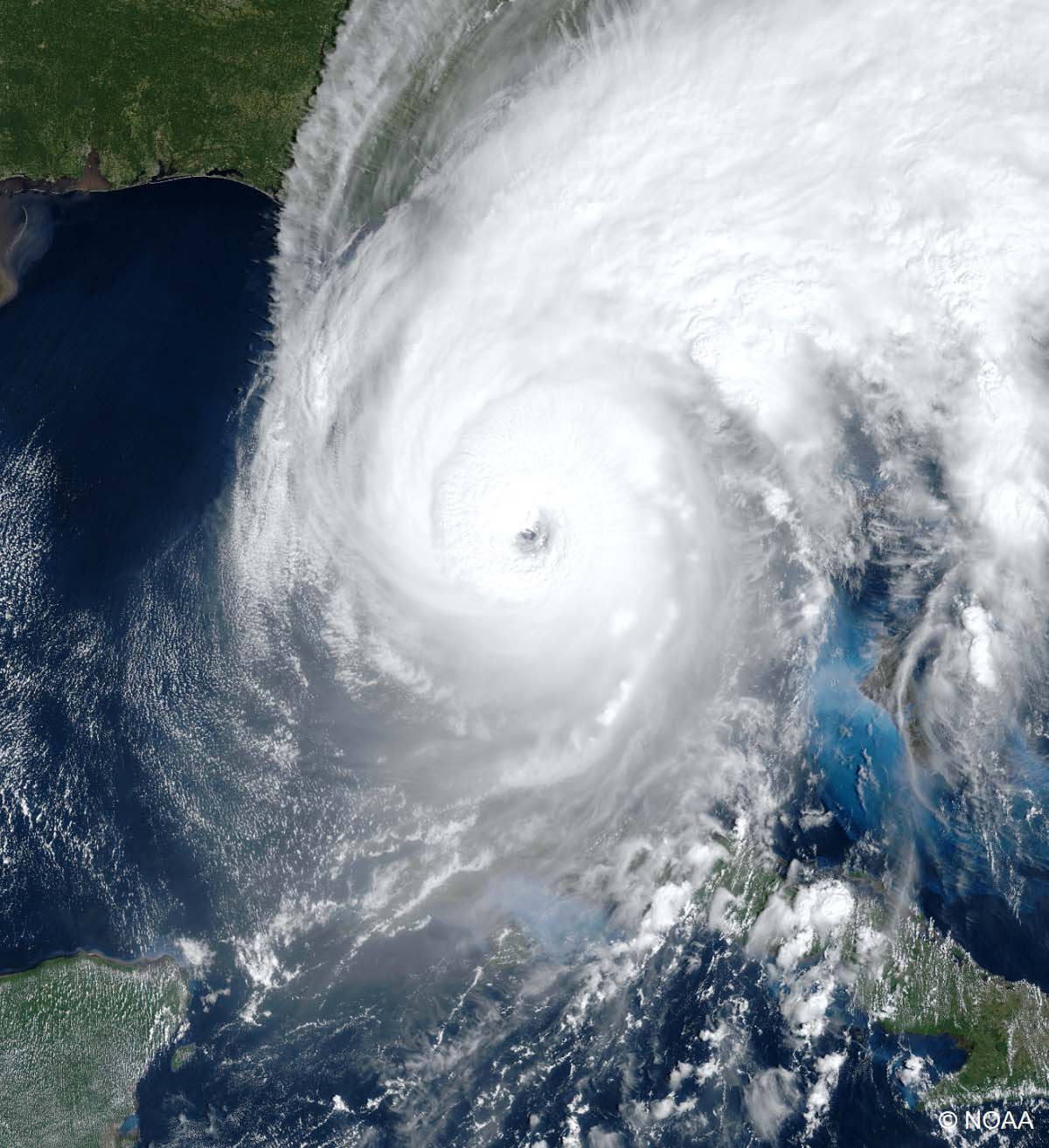
Judging by these outlooks above, the Atlantic storm season 2023 was forecast to be stronger than the one we had last year. To keep things on track, the 2022 season produced 16 total systems, where 14 of those were storms, and 8 were Category 1 or higher. The major storms were Fiona (Category 4) and Ian (Category 5), both occurred in September 2022.
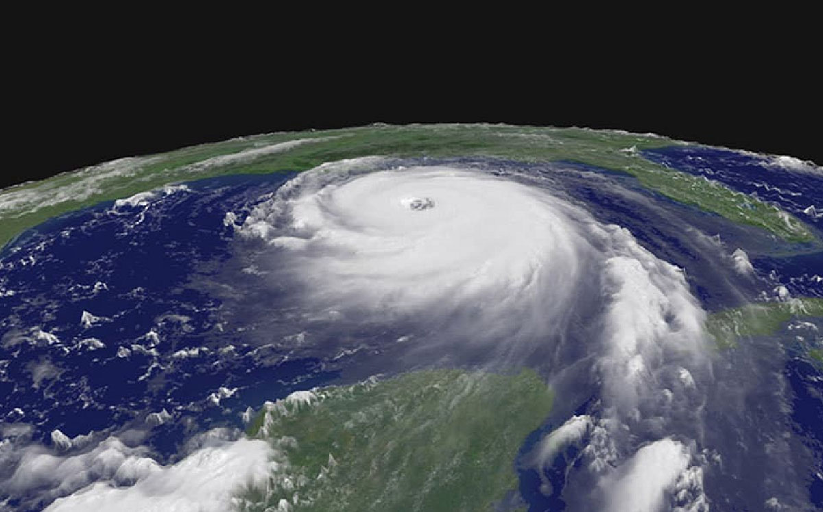
Below is a NOAA visible satellite view of Category 5 storm Ian, taken in the final days of September, when Ian was nearing the southwest Florida peninsula.
As discussed above, the Atlantic season runs from June 1st through November 30th. The region where we monitor these storms is known as the Atlantic basin. It extends across the tropical area, including the Atlantic Ocean, the Gulf of Mexico, and the Caribbean.
The long-term average of tropical systems in the Atlantic Basin (taken over the last 70 years – between 1951 and 2020) holds 11 named storms in one full season. However, the short-term average (taken over the last 15 years – between 1995 and 2020) is higher, with around 14 named storms. We can notice a gradual increase in the number of storms.

While a La Nina global weather pattern influenced the last three storm seasons, the 2023 Atlantic season has an El Nino effect. Which NOAA also forecasts to peak in the autumn and early winter months. El Nino is known to lead to lesser tropical activity due to stronger wind shear in the Atlantic Basin.
However, despite El Nino throughout the year and this year’s well-above-average Atlantic seawater temperatures, the upcoming peak activity weeks call for a busy period. These warmer-than-normal sea temperatures are also observed across the Caribbean, the Gulf of Mexico, and the rest of the North Atlantic.

The Atlantic, the Caribbean, and the Gulf are warmer than normal, including the region across the central parts known as MDR (the Main Development Region). The MDR extends between Africa and the Caribbean Sea. This warm region indicates that cyclone formation takes advantage of the warm and hottest-than-ever ocean waters.
Note that a tropical storm organizes and gains strength when specific weather conditions are met. Normally, we need a low-shear environment with very warm sea waters. The latter results in plenty of very moist air mass above the sea, the main source of thunderstorms.
ATLANTIC STORM SEASON 2023 ALREADY HAD 14 CYCLONES SO FAR
The WMO’s international committee (the World Meteorological Organization) has designated twenty-one cyclone names for the Atlantic storm season 2023. The list with all the cyclone names can be seen below, starting with Arlene and ending with Whitney.

So far, fourteen systems have formed in this storm season’s first four and a half months (out of six). There was one Category 5 storm, Lee, two Category 4 storms, Franklin and Idalia, and one Category 1 storm (Don). Before the official start, there was also one sub-tropical storm in January.
We use cyclones’ names for one main reason – to help quickly identify storms in warning messages.
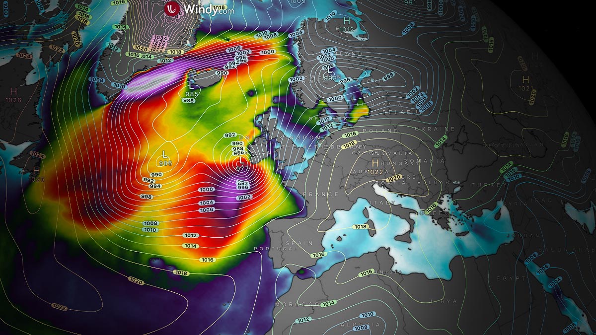
MARGOT FORECAST TO REMAIN CATEGORY 1 STORM FOR FEW DAYS, THEN TURN TOWARDS EUROPE, POSSIBLY THE UK AND IRELAND
The recent geostationary satellite imagery shows that the convective structure of Margot (right system) is still healthy, maintaining a strong Category 1 storm strength. The system is moving almost due north at about 8 kt, several hundred kilometers to the east of its larger brother, a solid upper-end Category 2 storm Lee.
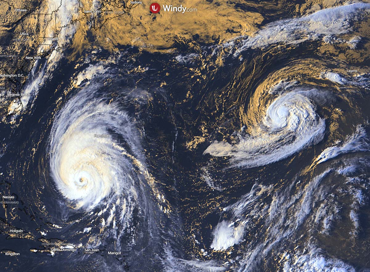
The track guidance suggests that the core of Margot and Lee will continue north as we head into the weekend. Lee will reach Atlantic Canada, while Margot will gradually turn northeast to the north of the Azores and head for impact on Western Europe.
The NHC intensity forecast suggests Margot will maintain a Category 1 for another two to three days. Then, storm Margot will likely be downgraded but remain a powerful Atlantic storm system as it nears Europe early next week.
The following chart indicates the potential track (left) based on various GEFS options, with the intensity forecast on the right.

Margot is forecast to remain a Category 1 storm until Saturday as it tracks to the north-northwest of the Azores archipelago. Some impact on the northernmost islands is possible over the weekend. Above-normal oceanic waters will help Margot remain a strong storm until it reaches Europe as a post-tropical cyclone.
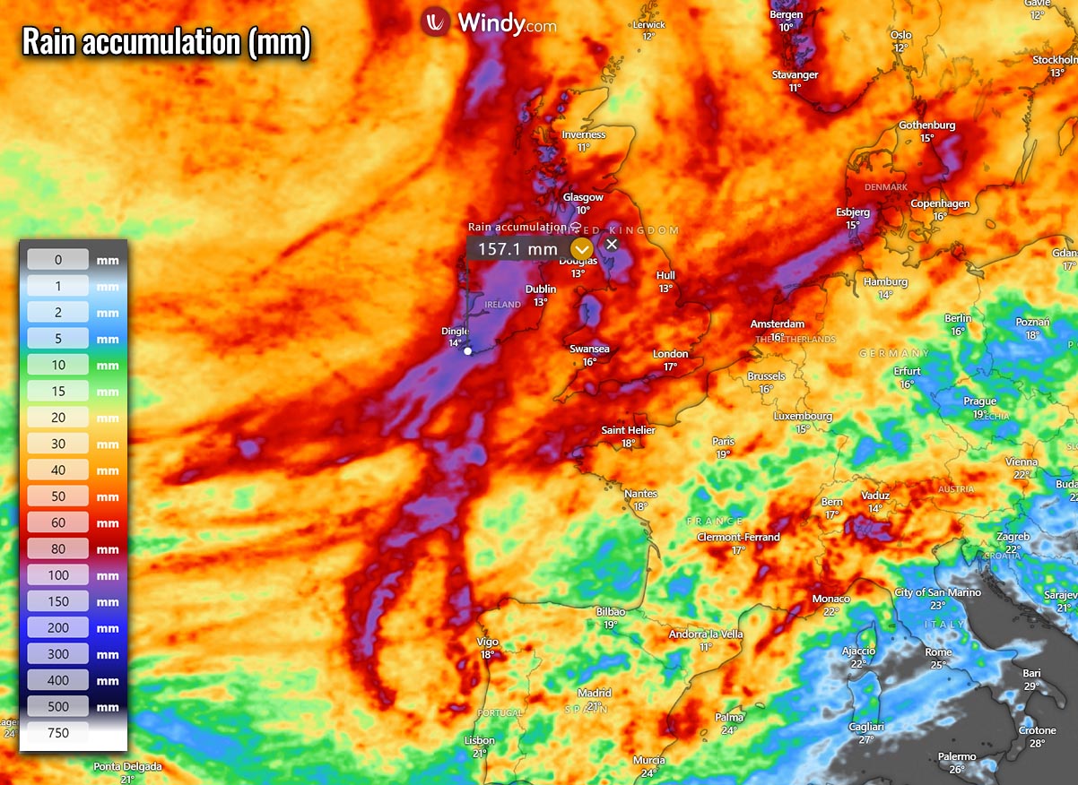
The following chart represents Margot’s potential peak wind gusts swath over the next ten days. A swath of severe winds is clearly seen as the storm continues towards western Europe. The impact could be to Ireland, southern England, or western France, with peak gusts exceeding 100 km/h and significant wave heights.
Some weather models also suggest that once storm Lee ejects off the Atlantic Canada impact, it may eventually merge with Margot into one large Atlantic system and head for western Europe.
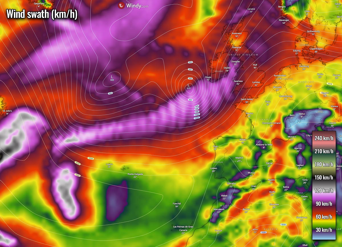
Margot will change its direction and track more toward the northeast after Saturday, taking its course towards western Europe. Although the exact future track has to be closely monitored, residents of Ireland, the southwestern UK, and France need to have close eyes on the coming storm.
The rainfall accumulation map below also indicates the amounts of rain will be significant and could lead to flooding in parts of Ireland and the UK.
If Margot eventually takes a more southerly track, west-northwest France must also monitor the storm’s potential impact.
EXTREMELY WARM ATLANTIC COULD BOOST FUTURE STORMS AND THEIR INTENSITY
As we discussed earlier, the extremely high water temperatures across the Atlantic Ocean, including the Main Development Region, have something that has never been observed before. This means that one of the most important conditions that fuel tropical cyclones is particularly anomalous – the heat content.
For a tropical storm to form, two meteorological features must be present:
- A weather disturbance, e.g., a cluster of thunderstorms that pulls in warm surface air (with high dewpoints) from all directions
- The water at the ocean’s surface has to be at least 26 °C (79° Fahrenheit)
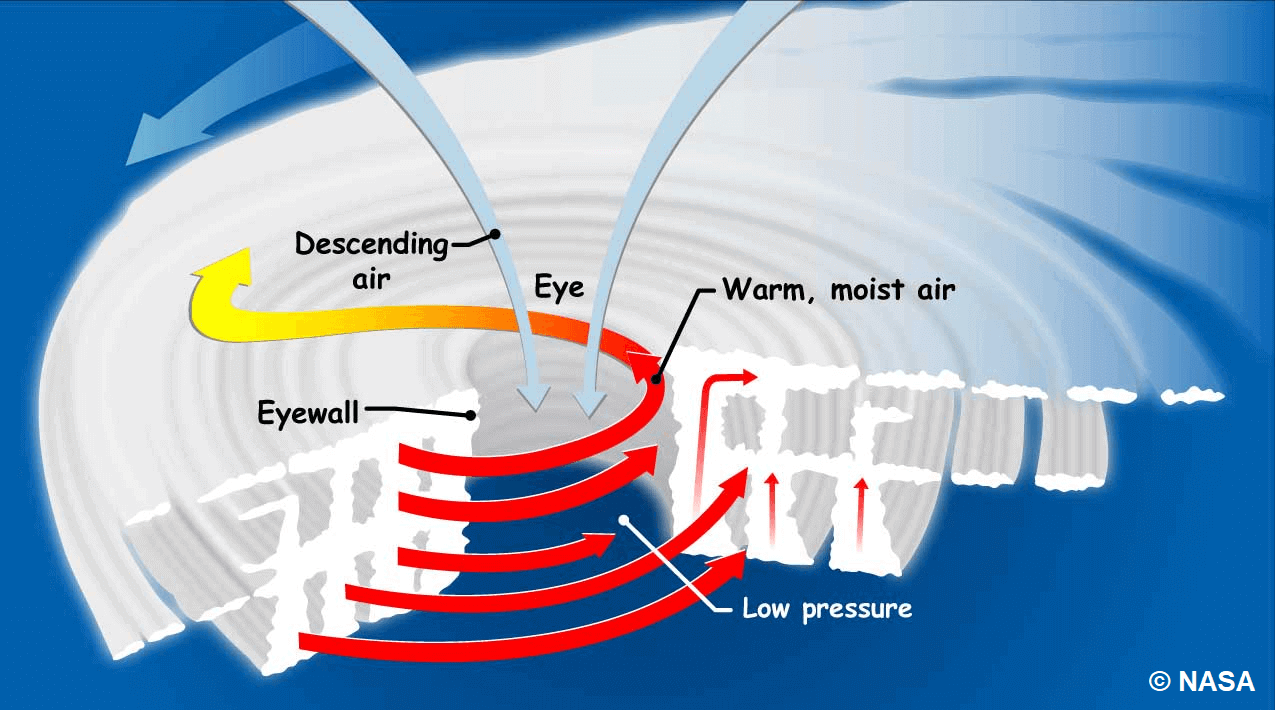
Because of the interaction of warm air and seawater that spawns thunderstorms, these cyclones form over the oceans between about 5 and 20 degrees of latitude. At these latitudes, seawater is warm enough to give the parent storms strength and the rotation of the Earth, which makes them spin.
These systems generally start with evaporating warm seawater, which pumps water into the lower atmosphere. Then, a significantly humid air mass is dragged aloft when converging winds collide and turn upwards.
As air rises to higher altitudes, water vapor condenses into clouds and rain, releasing heat. This warms the surrounding air, causing it to rise with the air far above the sea. Thus, upward-moving, even warmer, moist air travels from along the surface to replace it.
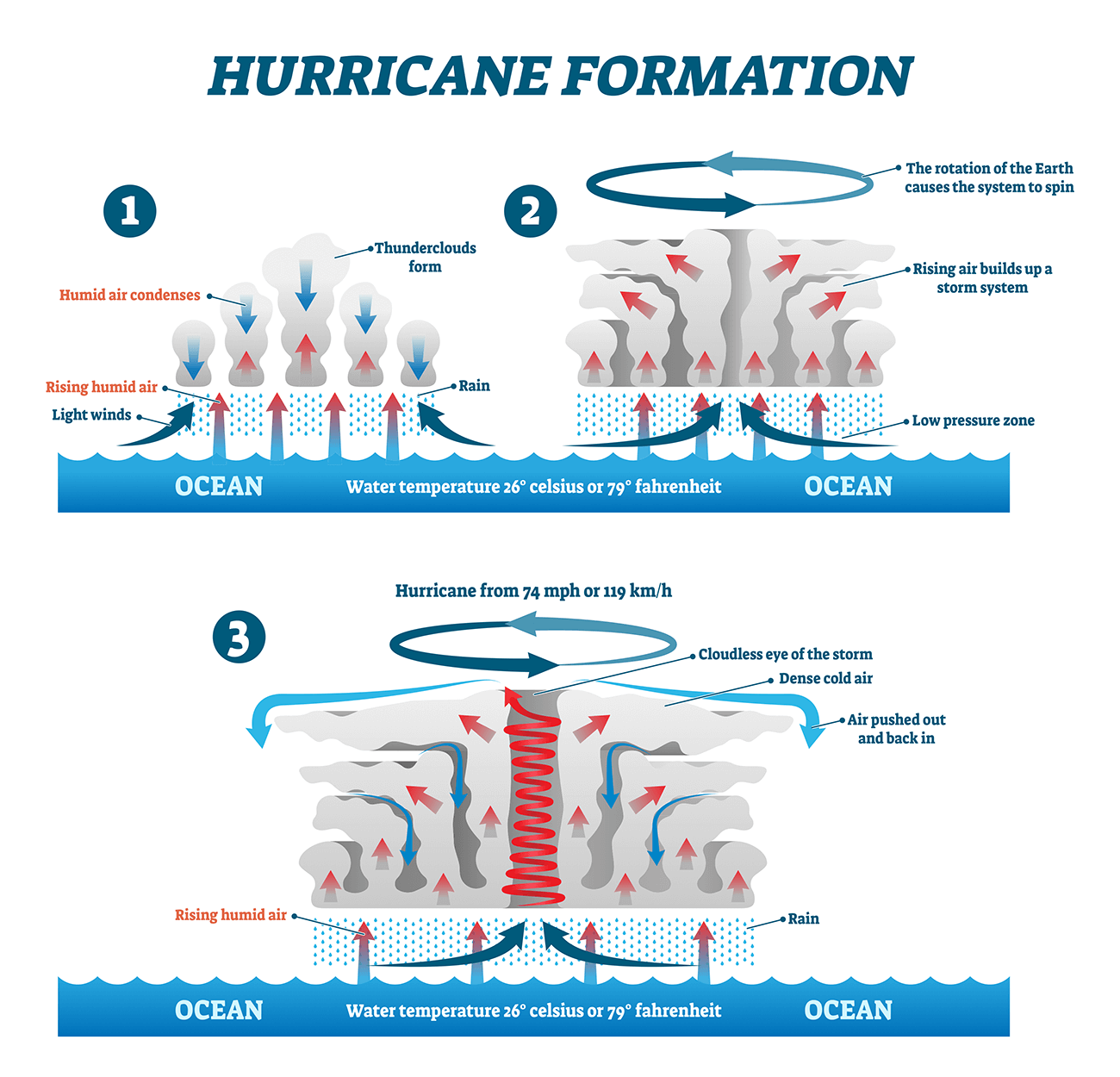
Therefore, as long as the base of this weather system remains over warm oceanic water and high-altitude winds do not shear apart its top, the cyclone will intensify and grow. More and more heat and water will be pumped into the air.
The surface central pressure at its core will drop further, sucking in the wind at ever-increasing speeds. Over several hours to days, the tropical storm (cyclone) will intensify, finally reaching greater strength.
A cyclonic system in the North Atlantic officially gets a Category 1 status when the winds that swirl around it reach sustained speeds of 74 miles per hour (64 knots or 119 km/h) or more.
Warmer oceans provide more potential energy for these systems, leading to stronger storms and especially a rapid intensification when they grow. Recent studies have shown a link between ocean surface temperatures and tropical storm intensity – The warmer waters lead to more intense and faster-growing storms.
So, as we learned, the two main ingredients tropical systems need for their formation and strengthening are (1) a general weather disturbance and (2) significantly warm oceanic waters. The latter has been in the record values for the North Atlantic.
Oceanic waters remained extremely warm throughout summer and generally peak in September, the most active period of the Atlantic Storm Season. This increases the chance that the upcoming tropical systems will take advantage of these conditions and support explosive and rapidly developing storms.
And they could have more tracks closer to the European continent, thanks to anomalous sea waters also over the northeast Atlantic.
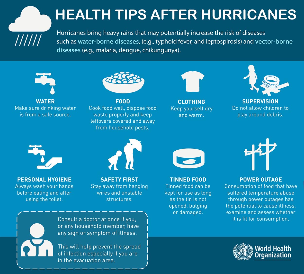
SAFETY PREPAREDNESS FOR THE STORM SEASON

Have a plan
The main storm season in the North Atlantic starts on June 1st and ends on November 30th. This is when you and your family have to be prepared by planning ahead.
- Write emergency phone numbers and keep them on the refrigerator or near every phone in your house. Program them into your cell phone as well.
- Prepare an emergency supply kit.
- Locate the nearest shelter in your area and different routes from your home in an emergency. If shelter locations in your area have yet to be identified, learn how to find them before the event of a storm.
- Pet owners: Take care of your pets at pre-identify shelters, a pet-friendly hotel, or an out-of-town friend or relative where you can take your pets in case of an evacuation. Local animal shelters can offer advice on what to do with your pets if you are asked to evacuate your home during a storm.
LEARN THE DIFFERENCE BETWEEN A “WATCH” AND “WARNING”
When you listen to the National Weather Service alerts on TV or radio or check for them online, there are two kinds of alerts:
- A watch means severe conditions (sustained winds of 74 miles per hour [mph] or higher) are possible in a stated area. The NHC will announce watches 48 hours before they expect tropical storm-force winds (sustained winds of 39 to 73 mph) to start.
- A warning is a more serious threat to deal with. It means violent winds are expected in a stated area. NHC issued these warnings 36 hours before tropical storm-force winds were expected in the area to give people enough time to prepare for the storm.
Check out the NHC for more information about watches and warnings. If you hear a watch or warning in your area, you can take steps to get ready.
GET YOUR CAR READY TO LEAVE HOME IF NEEDED
Make sure your car is ready before the tropical storm hits.
- Fill the car’s gas tank.
- Move cars and trucks into your garage or under cover.
- Always keep an emergency kit in your car.

If you don’t own a car, consider making plans with friends and family or call authorities to get a ride if you need to evacuate.
GET YOUR FAMILY AND PETS READY
- Go over your emergency plan with your family; understand everything.
- Keep checking for weather updates about the storm. Watch TV, listen to the radio, or check the NHC website online.
- Call the hospital, public health department, or the police about special needs. If you or a loved one is older or disabled and won’t be able to leave quickly, get their advice on what to do.
- Put pets and farm animals in a safe place.
GET YOUR HOME READY
- Clear your yard to ensure nothing could blow around during the storm and damage your home. Move bikes, lawn furniture, grills, propane tanks, and building materials inside or under the shelter.
- Cover up house windows and doors. Use storm shutters or nail pieces of plywood to the outside window frames to protect your windows. This can help keep you safe from flying debris and pieces of shattered glass.
- Be ready to turn off your power if you see flooding, downed power lines, or you have to leave your home. Switch your power off completely.
- Fill clean water containers with drinking water if you lose your water supply during the storm. You can also fill up your sinks and bathtubs with water for washing.
- Double-check your carbon monoxide (CO) detector’s battery to prevent CO poisoning.
BE READY TO EVACUATE OR STAY AT HOME
During a warning, always listen to authorities regarding whether you should evacuate or stay home.

If a storm is coming, you may hear an order from authorities to evacuate (leave your home). Never ignore an order to evacuate. Sturdy, well-built houses may not hold up against a storm’s power. Staying home to protect your property is not worth risking your family’s health and safety.
There are occasions when you may hear an order to stay at home. If driving conditions are too dangerous, staying home might be safer than leaving. Respect the authorities’ decisions.
If you need to evacuate:
- Grab your emergency supply kit and only take what you need (cell phone, chargers, medicines, identification like a passport or license, and cash).
- Unplug your appliances. If you have enough time, turn off the gas, electricity, and water.
- Follow the roads that emergency workers recommend even if there’s dense traffic expected. Other routes might be blocked or already flooded. Never drive through flooded areas, as cars and other vehicles can be swept away or may stall in just 6 inches of moving water.
- Contact your local emergency management office and ask if they offer accommodations for owners and pets.
If you need to stay home:
- Keep your emergency supply kit anywhere where you can easily access it anytime.
- Follow weather updates online from NHC, and listen to the radio or TV for updates on the storm.
- Stay inside. Even if it looks calm, don’t go outside. Wait until you hear an official message that the storm is over. Sometimes, the weather gets calm in the middle of a storm but then quickly worsens again.
- Stay away from windows — you could get hurt by flying debris, such as pieces of broken glass or other objects winds pick up around the neighborhood during the storm. Stay in a room with no windows, or go inside a closet.
- Be ready to leave home. If emergency authorities order you to leave or your home is severely damaged, you may need to go to a shelter or a neighbor’s house.
Our expert forecaster team will actively follow the tropical region activity worldwide, including Atlantic Basin systems and tropical cyclones likely to affect the United States, the Caribbean, and Europe again in the following months.
Stay tuned for further follow-up posts, in-depth forecast discussions, and nowcasting during the coming weeks and the upcoming Atlantic storm season 2023 peak weeks. We will make you prepared.
Windy, NOAA, NHC, Colorado State University, Tropical Tidbits, and WHO provided images used in this article.
See also: