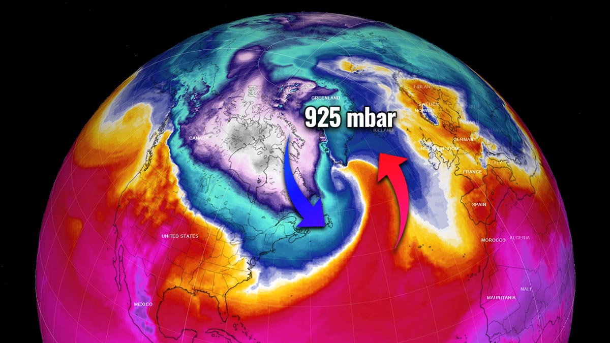
A Winter Storm Quinlan has finally ejected off the Northeast U.S. this Sunday, leaving a swath of snow from the central high Plains across the Mississippi and Ohio Valley to New England. Record Arctic cold air hit the Southeast states with temperatures below freezing also along the Gulf Coast in many areas. The system is now heading into the North Atlantic and continues rapidly intensifying under the deep cold-core left behind the Polar Vortex after the breakdown. Quinlan is a powerful Nor’Easter storm and will be the deepest bomb cyclone of this cold season, bottoming out around 925 mbar in the Labrador Sea on Monday.
The general pattern that sparked the most recent winter storm, Quinlan, is now finally ejecting the system off of the North American continent, while it keeps gaining strength. With a very cold air in its wake clashing into the strong advection of much warmer, sub-tropical air from the south, Quinlan is expected to become the most intense Atlantic bomb cyclone of the year. The general weather model consensus hints at its central pressure to reach the mid-920s by Monday, before gradually turning towards Greenland and Iceland on Tuesday.
This part of the North Atlantic has had a pretty dynamic weather pattern lately, with a lot of strong and deep lows in recent weeks. Some of them brought violent windstorms to western Europe if we just remember the storm Eunice. Thanks to the final breakdown of the Polar Vortex that has been particularly intense this cold season 2021/22, the remnants of deep cold air will support additional explosive development of Quinlan into a violent extratropical storm tonight into Monday.
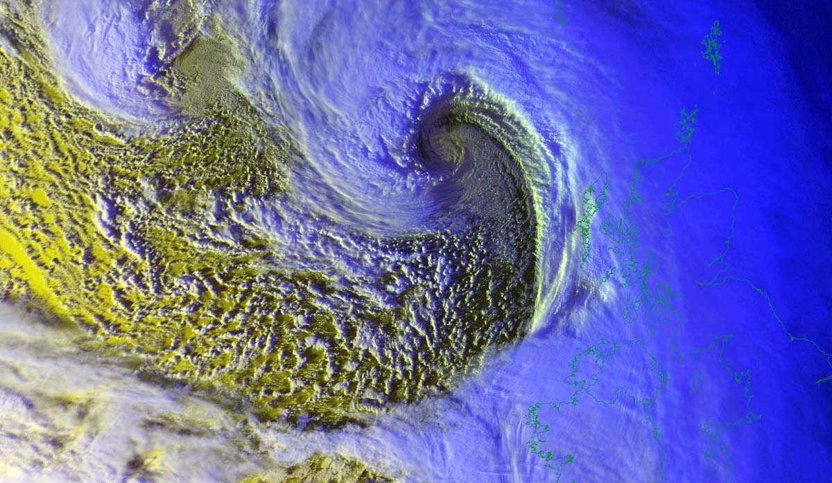
A rather similar weather system hit almost the same region in early February when the Winter Storm Landon traveled into Northwest Atlantic and become very intense Nor’Easter. Monday’s storm will be even more intense, forecast to become the system with the deepest central pressure. Besides its central pressure, also the wind intensity and the size of the storm will be huge. The geocolor satellite image below indicates how this system was in rapid development leaving the Northeast U.S. early Sunday morning.
The satellite reveals a textbook structure of the initial stages for explosive cyclogenesis after the intrusion of much colder, Arctic air mass from the continent into the warmer air over the Atlantic ocean. A sharp cold front is also seen at the edge of the high moisture advection from the Caribbean region, dragging the air mass from the deep tropical region towards the Northwest Atlantic. These are the perfect conditions for a very powerful extratropical cyclone.
The new Atlantic storm is forecast to significantly deepen (more than 30 mbar in 24 hours) through Monday morning and blast the southern Labrador Sea and the southern tip of Greenland with destructive winds, major waves, freezing spray, heavy snow, and blizzards. The video animation below indicates the rapid development of this low as it ejects off eastern Canada and continues towards Iceland in the next 48 to 72 hours.
This new Atlantic storm has all ingredients set to support its explosive nature until reaching its peak on Monday, generating hurricane-force winds with the highest gusts peaking close to 200 km/h (125 mph). Some weather models also hint at the development of the sting jet phenomenon, a region of the extratropical storm where the most destructive winds often occur.
This particularly cold Arctic air, spreading into the warmer Atlantic has boosted Quinlan into the next Nor’Easter bomb cyclone, supported by really deep upper levels as we see on the chart above. The further shift of it into the Northwest Atlantic will help it to become the deepest extratropical storm of the Winter Season for the region, even stronger than a month ago there.

These so-called cyclonic bombs are very powerful winter storms, often resulting in significant damage when they hit the land areas. With the violent winds and significant wave heights, they are a particularly dangerous threat for marine traffic as well. Do you know why they have such a name and why are they so dangerous? Let’s have a brief look at their origin and background processes.
HOW POWERFUL STORM IS THE BOMB CYCLONE?
The North Atlantic (or North Pacific) sometimes develops some very powerful storms, and we can’t miss those impressive satellite images. They are actually very dangerous, and meteorologically speaking, also very didactic and outstanding weather systems as their development is very rapid. This means the central pressure of these storms is falling very rapidly and these systems are then known as bomb cyclones.
The Nor’Easter storm Quinlan is a perfect example of this, as the pressure change this weekend into Monday is rapid, it has easily met the criteria for such meteorological classification.
In other words, the surface cyclone intensifies so fast that its central pressure is falling very rapidly, often extremely fast. The process behind is known as bombogenesis, as such a system has explosive cyclogenesis ongoing. Leading to an extremely rapid deepening of its barometric pressure.
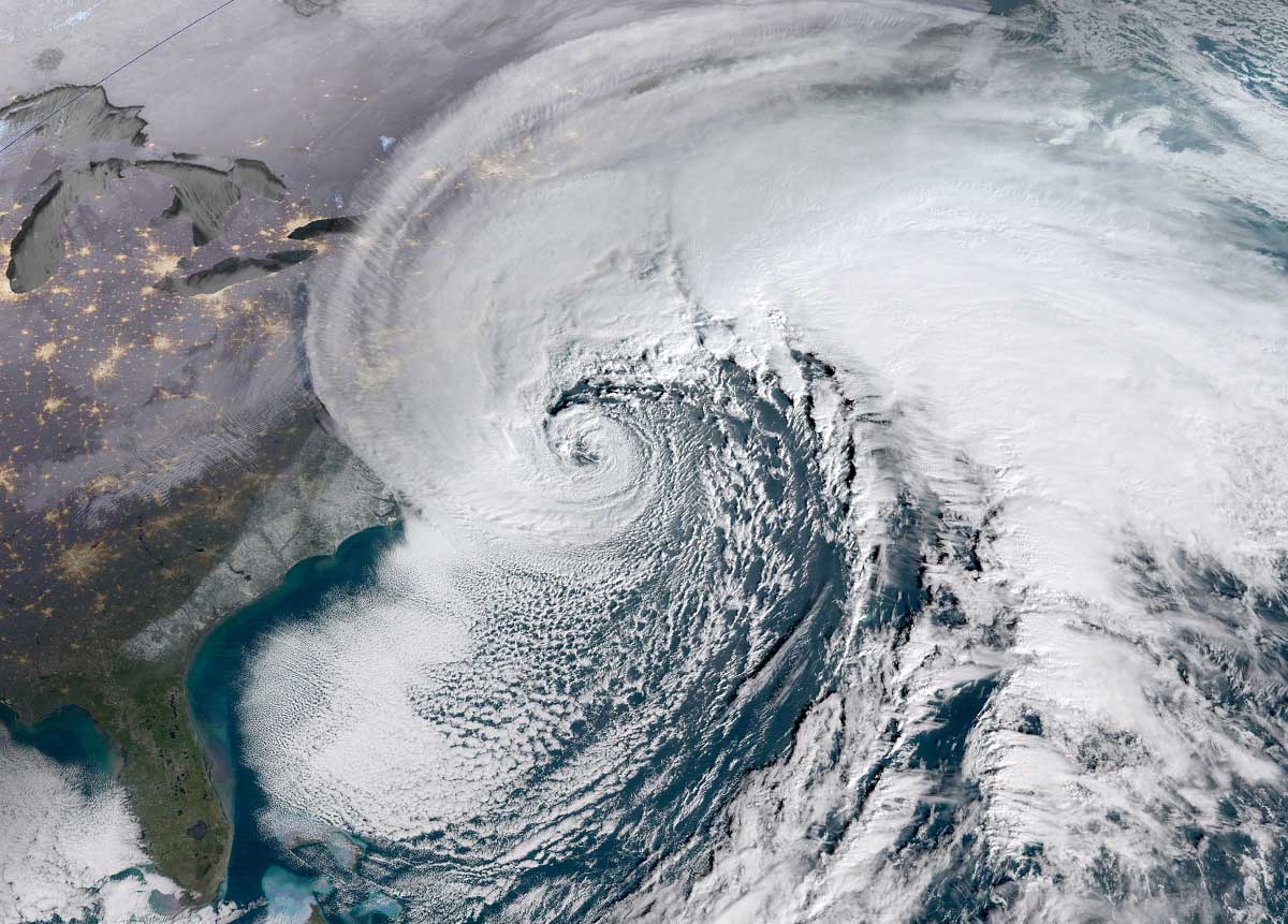
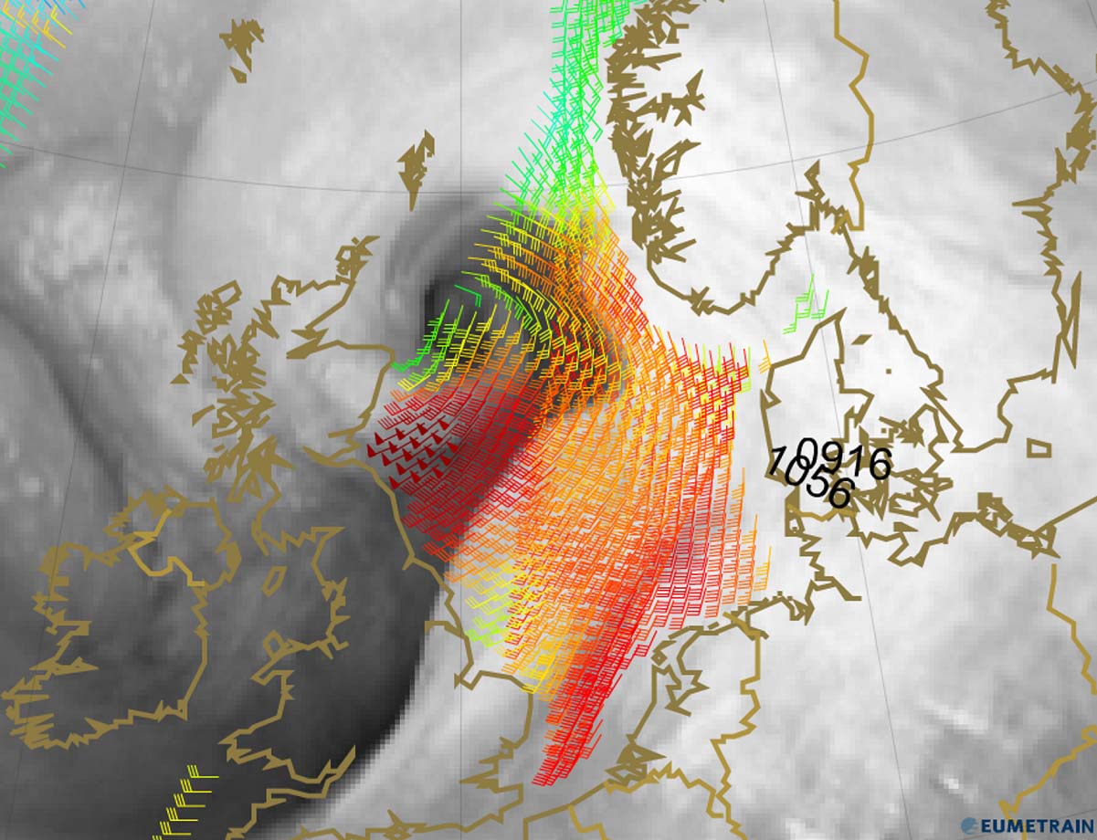
Just technically speaking, a pressure fall of at least 24 millibars within 24 hours is the main criteria that the cyclonic system needs to meet that can be officially classified as a bomb cyclone. Such a system is a non-tropical storm, also known as an extratropical cyclone. It develops very fast from a classic low-pressure system, usually in a timeframe of 12 to 36 hours. The above satellite image is a textbook example of such a bomb cyclonic storm, a typical Nor’Easter along the Northeast U.S. coast.
Extratropical storms normally grow a very large size, dominating a large portion of the Atlantic ocean. Due to the Coriolis effect, the general movement of these types of cyclones in the Northern hemisphere is towards the northeast. The cyclone’s size produces very intense and extremely severe, hurricane-force winds, generating significant wave heights and swell across a broad area and threatening marine traffic.

Similar to the classic extratropical cyclone, Atlantic bombs are fueled by variations in the temperature, so between the warmer temperatures coming from the subtropical region and the much colder temperatures coming down from the Arctic region.
This process also occurs vertically throughout the atmosphere. Keep in mind that these lows are different from tropical cyclones that we normally see during the Atlantic hurricane season. Hurricanes receive their main and only fuel energy from extremely warm sea surface temperatures found in the tropical region.
The east coasts of the North American continent and Northwest Atlantic coasts are the perfect breeding grounds for these types of extratropical cyclones during the late fall and winter months, sometimes also in early spring. This region, with the interaction of the Arctic cold continental air mass and warmer, moist ocean tropical air mass provides a ton of energy for systems to rapidly develop into cyclonic bombs. These lows often literally explode once they emerge into the warmer Atlantic.
Bombs are pretty common during the winter months in the North Atlantic, but they can occur all year round. These so-called Atlantic bombs, also include post-tropical systems that sometimes rapidly reform from a decaying tropical cyclone or hurricane when they travel far north towards Europe.
The statistical data reveals that there are about 60-70 such cyclone-type formations on Earth every year. About 40-50 of them occur in the Northern Hemisphere, particularly off the east coasts of the U.S. and the North Atlantic where the interaction of the Arctic and subtropical air masses are meeting together more often.
There are also other similar found in the northwestern Pacific around Japan, another two regions with favorable conditions for these systems. Even Australia can get several of them during their cold season each year, although they rarely have so rapid intensification as the Atlantic or Pacific storms in the northern hemisphere.
POLAR VORTEX HELPS TO DEVELOP FOR ANOTHER ATLANTIC BOMB THIS WINTER SEASON
The ongoing weather system is actually pretty similar to what we have seen at the end of January’s cyclone and violent Nor’Easter along the Northeast U.S. coast. This was followed by early February’s Winter Storm Landon, transforming into a cyclonic bomb over nearly the same area of the Northwest Atlantic. Despite the final breakdown of the Polar Vortex recently, its remnants of very cold upper levels are yet again helping these systems to explosively develop into Atlantic bombs.
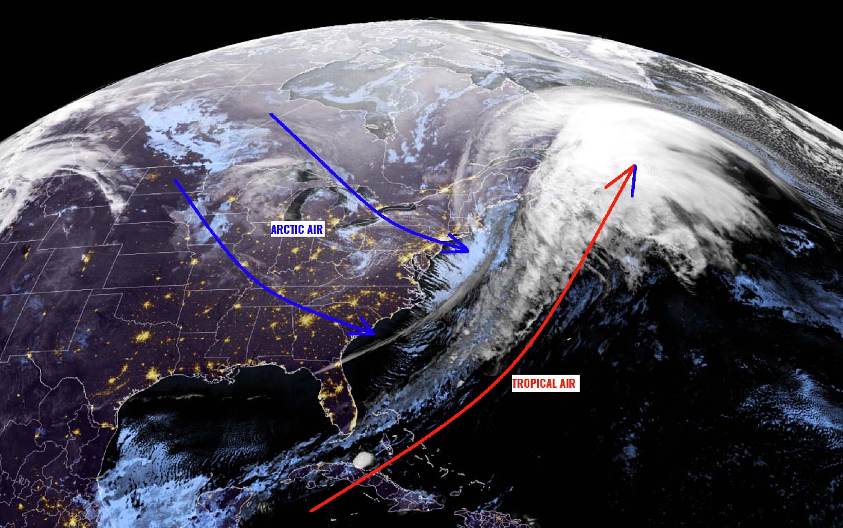
The satellite image below reveals a very impressive, yet textbook example of the developing storm. Strong warm advection ahead of the system, and a huge reservoir of Arctic cold air mass pushed in its wake. The approximate storm track is marked by the black arrow.

A huge baroclinic zone is stretching on the nose of the Arctic cold blast over the far Northeast U.S., pushing the departing storm across Newfoundland towards the open Northwest Atlantic Ocean and the Labrador Sea. A battle of two pools with opposite conditions, the Arctic cold versus the warmer and moist sub-tropical air will occur from the south. Their interaction is leading to a very explosive development of a bomb cyclone.
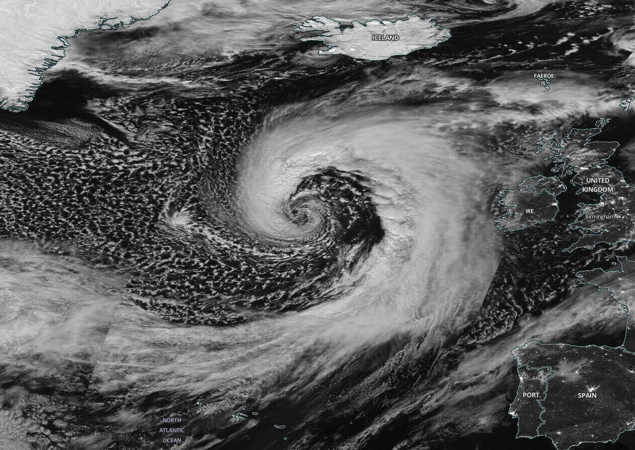
With the rather typical process of this kind of weather system, storm Quinlan will be undergoing a bombogenesis process for nearly 48 hours. It started on Saturday morning and will reach its final strength and mature stage on Monday afternoon, becoming a very violent extratropical storm near the southern tip of Greenland Monday afternoon into the evening. We will see its structure pretty spectacular on the satellite imagery when the peak intensity occurs, similar to the one below.

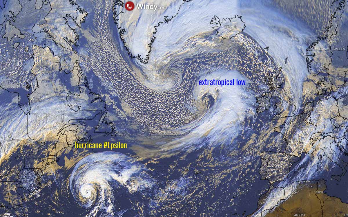
Satellite images typically reveal an appearance of the cloud bands that are symmetrically wrapped into a tightening core when this occurs.
The example below is such a system back from October 2020, when we had an extratropical storm with a company of hurricane Epsilon farther south in the Atlantic.
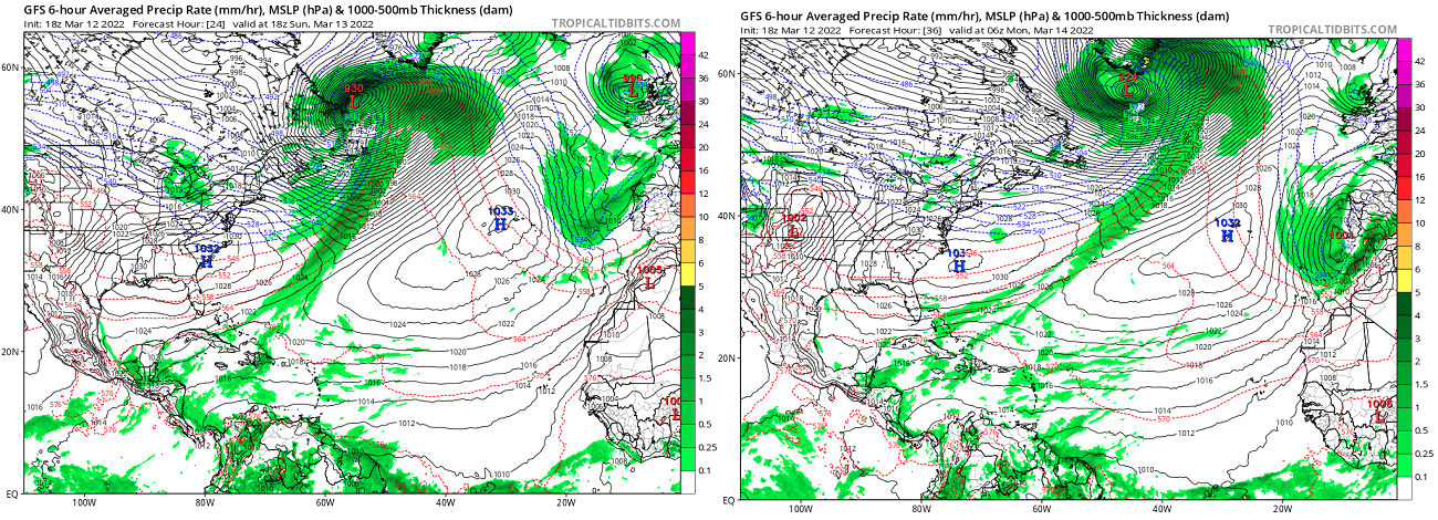
The NOAA Ocean Prediction Center (OPC) analysis on Sunday 12 UTC (chart below) has revealed that the system already had a central pressure of 948 mbar, centered just north of Newfoundland, Canada. There was more than 40 mbar pressure drop in just 24 hours period, nearly double the criteria for a bomb cyclone.
We can nicely see a frontal system with a warm front moving across the Labrador Sea and the surface cold front extending far southwest to the east of the U.S. down to Cuba in the tropics.
The chart already hints at a continued rapid intensification process that is forecast for another 24 hours, so until Monday afternoon when the system should be near its peak and push the central pressure to near 925 mbar. That’s nearly 25 mbar lower than on Sunday afternoon. We can also see a large surface high-pressure system developed in the cold air behind the cold front, covering east-southeast U.S.

The heavy freezing spray will develop due to severe, near hurricane-force winds in the system’s wake, blasting the eastern Newfoundland and most of the southern Labrador Sea up to the southern tip of Greenland. Marine traffic crossing this region from Sunday until Tuesday will be battling some dangerous conditions of violent winds, and significant wave heights, likely up to around 15 meters.
So, the central pressure in this extratropical storm should have an astonishing 65-70 mbar drop over the 48-hour period, between Saturday 12 UTC and Monday 12 UTC. If we remember the criteria for a bombogenesis pressure change of 24 mbar in a 24-hour period, this system will reach double the threshold for explosive cyclogenesis.
The overall process of rapid intensification has started on Saturday morning, when the surface low began deepening its central pressure in a faster fashion, soon as its core was fueled with the much warmer air over the Atlantic. Soon after, the more rapid to occasional explosive deepening is underway and should bring it into the mid 920s by Monday afternoon.
Quinlan will become the deepest bomb cyclone of the cold season so far, even deeper than the last intense low in the region a few weeks ago.
This is no doubt a textbook appearance of explosive development, especially as we see the pressure will bottom out extremely low! With the weather models forecasting the pressure should bottom out at around 924 to 926 mbar, this will become one of the strongest (deepest) systems in recent years. The pressure falls are pretty remarkable throughout the whole rapid intensification process.
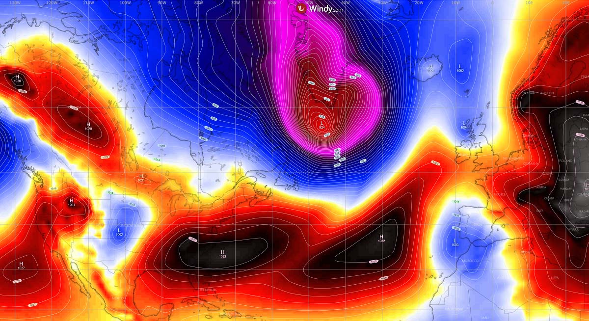
The wider view of the surface pressure forecast on Monday (chart above) can hint us how huge a pressure difference is between the center of the low and the surface High across the U.S. East Coast or over the Azores. There will be more than 100 mbar pressure differences, leading to very violent winds in between these two large-scale features. The jet stream will be very intense also for the crossing air traffic.
ATLANTIC BOMB REVEALS A TEXTBOOK WARM SECLUSION AGAIN
Over the North Atlantic, strong warm advection between the bomb cyclone Quinlan and the Azores High will maintain warmer weather far north, also towards western Europe. But it the immediate wake of the system, the northwesterly winds will drag the frigid, Arctic cold air mass. The following image indicates a pretty didactic fluid dynamics picture of how the large-scale processes lead the ongoing weather system across North America, the Atlantic, and towards Europe.

This impressive temperature contrast picture is also pretty textbook when it comes to the violent extratropical lows in the North Atlantic. Extremely cold Arctic air is spread across eastern Canada, with temperatures from -20 to -30 °C in places, nosing down into the northwestern Atlantic.
Farther east, the violent force of the exploding cyclone does the contrary. A very strong warm advection of subtropical air mass will be dragged very far north, rounding the center low with a classic comma shape visible on the temperature map. This is known as warm seclusion, defining the time when a mature phase of the extratropical cyclone lifecycle is near.
Warm seclusion events may have cloud-free, eye-like features on the satellite imagery at their center, and can sometimes be reminiscent of tropical cyclones. This feature indicates that the system’s warm-core center is surrounded by hurricane-force winds along the bent-back warm front as seen on the chart below. After this phase, the mature stage of the system is in full mode, so a storm starts its decaying process and no further intensification is possible.
However, this kind of system and pattern is actually quite classic during the winter months for the North Atlantic, occurring soon after intense Arctic outbreaks from Canadian Arctic and Greenland penetrate onto the much warmer sea waters coming us from the Gulf Stream warm channel. A system of such scale will produce violent winds and waves, with the winds being particularly intense in a small area that sometimes occurs.
These parts of the extratropical cyclones are as the sting jet wind maximums. Here is how they form and why it is important to know if they will develop.
WHAT IS STING JET WIND MAXIMUM?
A sting jet is a narrow core of violent winds that sometimes form within the rapidly intensifying North Atlantic extratropical bomb cyclones, developing powerful windstorms towards the ground. They are associated with the strongest and most damaging windstorms resulting in violent, hurricane-force winds.
Sting jets are the meteorological phenomenon that is often blamed to produce violent, hurricane-force winds with the most notable events so far. This phenomenon results in a narrow swath of particularly intense winds, often leading to peak wind gusts well above 150 km/h (90 mph). Sometimes even surpassing the 200 km/h (125 mph), causing extensive severe damage if it hits the land. a textbook example is the historic European storm Jorge below.

This relatively narrow zone of the storm’s wind maximum is originating from the inside of the mid-tropospheric cloud head within the explosive cyclogenesis or a bombs in the Atlantic or the Pacific Ocean.
But how it actually forms?
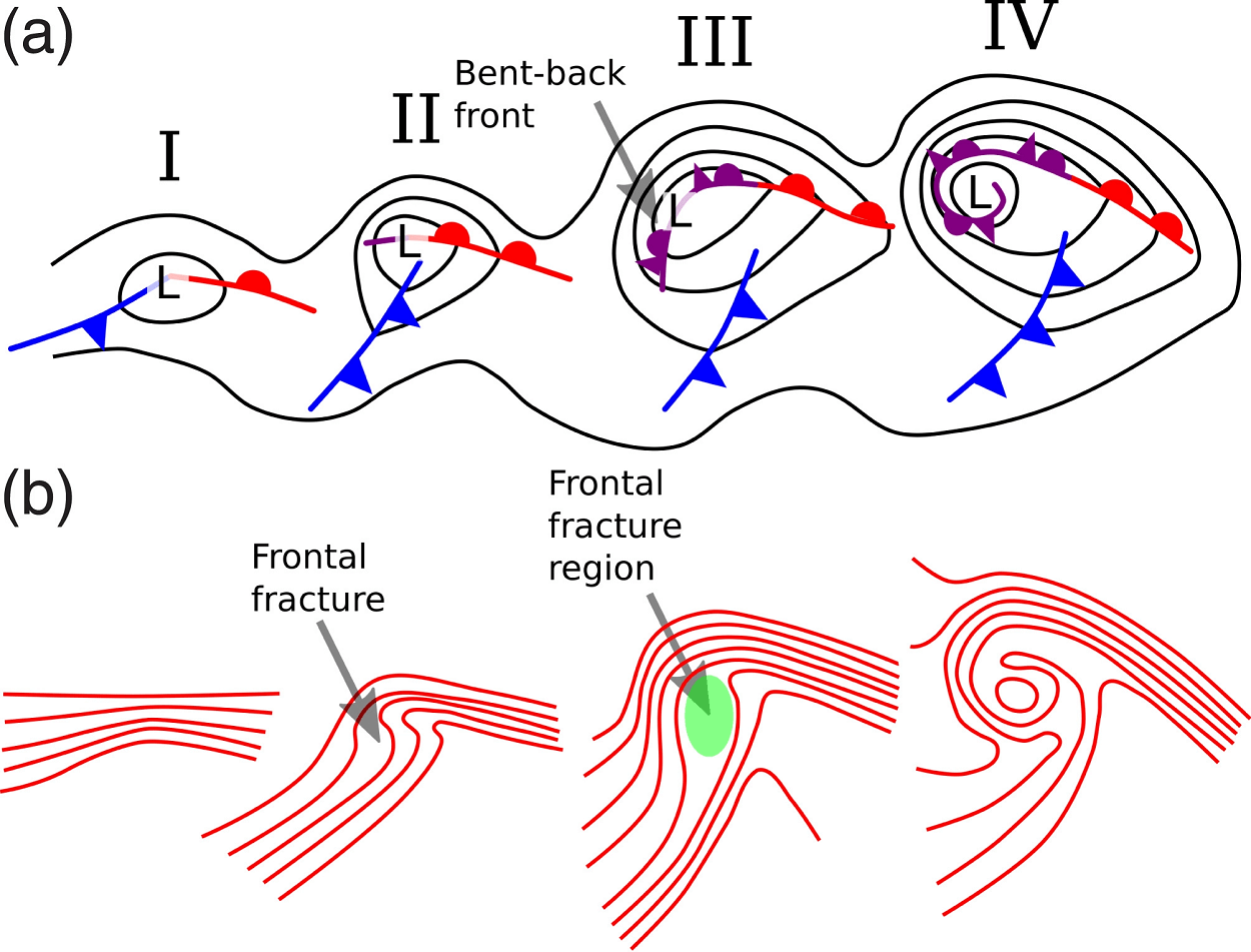
The extratropical cyclone has two frontal zones, the first is the warm front, followed by the cold front behind it. A strong flow of cold air develops into the low ahead of the warm front, known as the cold conveyor belt.
While behind the main cold front, a colder and also much drier air mass, often originating from the Arctic region, flows towards the core of the bomb cyclone. This is a process called dry intrusion, advancing towards the center of a deepening low. The dry intrusion is typically rounding the low, emerging from the southwest direction, curving towards the north-northwest when it comes into the dead core of the low.

The cold conveyor belt brings cold and moist air towards the center of the explosively developing extratropical storm, together with precipitation such as rain and snow. But the dry intrusion brings cooler and very dry air into the cyclone at the same time.
When the precipitation from the cold conveyor belt falls into the layers of air within the dry intrusion streak, droplets are quickly evaporating and leading to further cooling of the air mass. Thus, leading to a process known as evaporative cooling.
At the final stage of the sting jet process, already very strong winds descend towards the surface and are intensifying further as the air parcels are drying out. These winds are now grazing faster through the layers with the evaporation of the air on the nose of this descending jet. Creating a clear path through the precipitation with the evaporative cooling process leads to the air becoming much denser within the jet.
The result is the acceleration of the downward momentum. This, in other words, means that very strong winds are pushed down with even higher force towards the tip of the cloud head when it wraps around the cyclone’s center.
These processes within the jet are occurring at altitudes up to about 3-4 km above sea level surface. The entire region of this cooled, accelerated airflow is narrow, often just 50-200 km across, is then known as a sting jet.
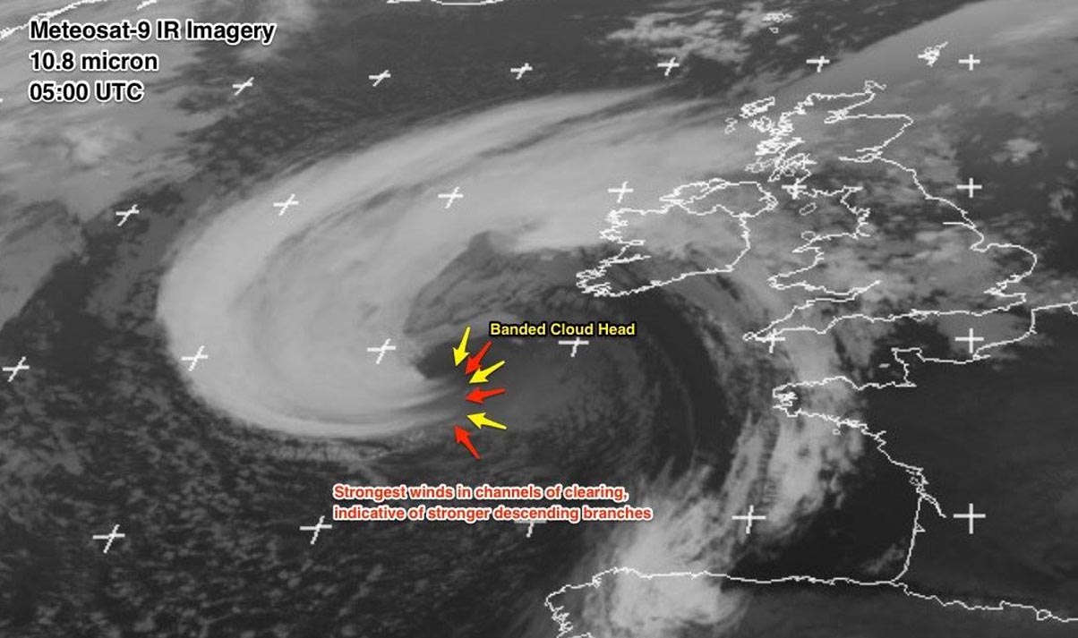
Once the phenomenon is fully developed, this wind maximum is also very easily recognizable on the satellite imagery. The shape of the cyclone’s comma cloud is seen as hooked just like a scorpion’s tail. This gives this dangerous wind region its famous name.
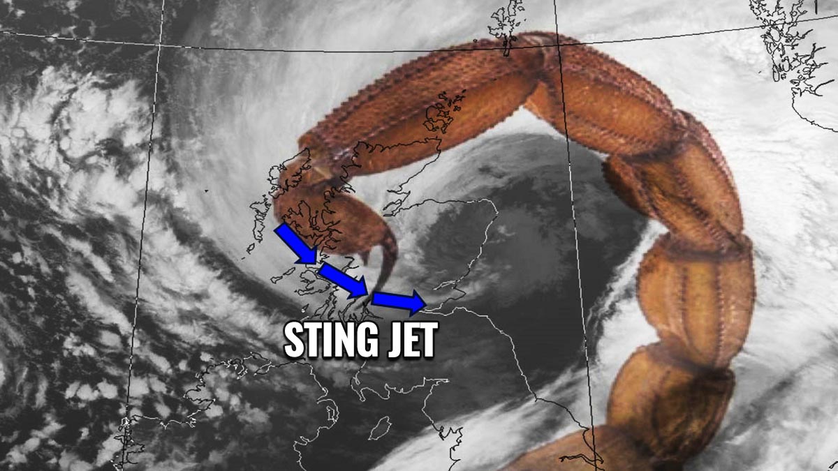
The composite satellite image above hints at the textbook example of the bomb cyclone with a sting jet, overlapped with a scorpion’s tail. Hence the name now, right?
As mentioned earlier, they usually affect only a small region of about 100-200 km (100-125 miles) across and is compared to the size of the parent large bomb cyclone actually pretty small. But it is the most dangerous part of the storm. The phenomenon usually lasts only for a maximum of several hours, but if it spreads across the land and coastal areas, destructive winds will occur.
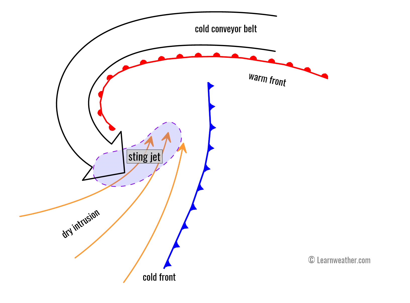
So, when we see Atlantic storms developing very rapidly or explosively as we did with storm Landon and now with Nor’Easter storm Quinlan, we can expect their typical satellite appearance of the banded cloud heads could be resulting in a jet wind maximum. The cloud head is strongly curved towards the core of the cyclone from where the most intense winds will likely push down towards the sea surface.
These cloud bands on the edge of the comma cloud will disappear quite sharply on the nose of the sting. This happens due to the effect of strong evaporation of the air parcels within the dry intrusion.
How do we forecast these events?
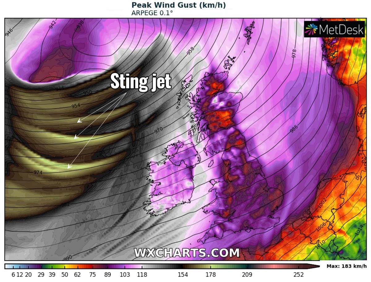
Sting jet winds are actually quite difficult to forecast as they are relatively small in size, and because it is also depending on how the cyclonic system has developed from its initial stages. But with the high-resolution weather model forecast charts nowadays, we are able to recognize the streaks of particularly violent winds inside the strong wind field with the cyclone in general. One obvious example is seen below.
Thankfully, with all the satellite technology available, we are also able to spot the sting jet developing once the weather charts hint at its potential development with some storms. As we learned, the end of the cold conveyor belt hints at the sting by a hook-shaped cloud, so we can assume that this wind maximum has higher chances to develop as well
So we will often use satellite images representing the amount of water vapor in the air, those are usually made up of light and dark shades. The darker the shade is painted, the less water vapor is present there. As we know that clouds form when water vapor condenses into water droplets, but around the stings, there are often dark fingers of air stretching out, telling us that the rollercoaster of wind is also very dry. This will help to spot this small core of fast-moving, cold, dense, dry air.
VIOLENT, HURRICANE-FORCE WINDS AND SIGNIFICANT WAVES UP TO 15m
The system’s most violent winds maximum will remain across the Labrador Sea, and northwest Atlantic, also graze across far eastern Canada and southern Greenland until Monday evening. Particularly severe to hurricane-force winds will also continue to spread east, across the broad area towards Iceland.

The accumulation of wind gusts (chart above) hints at how a large part of the North Atlantic will be affected by this violent storm Quinlan. The peak wind gusts will likely exceed the 180 km/h (110 mph) on the northern and west-southwest side of the low, grazing also across southern Greenland.
These parts of the bomb cyclones are often most dangerous when such storms occur as the pressure gradient between the center of the low against the very high pressure across the Greenland icy high plateau is extreme. Most of the time such low systems lead to a more than 80 mbar pressure difference, thus translating into powerful winds. The tighter the pressure, the stronger the winds.

A front-end of the bomb cyclone will also spread very powerful winds towards Iceland on Tuesday, with gusts from 180-250 km/h (110-150 mph) in the most exposed areas and highest peaks. It is important to remember that the bomb cyclone will be so deep, and when it nears Iceland, the pressure gradient will also be significant across the whole country. So the winds will be severe in most of Iceland’s lowlands as well.
This means that the peak wind gusts could reach from 120-150 km/h in some areas, being extremely violent over the exposed areas where the downslope flow will be enhanced by the slopy terrain. As well as higher in the ice caps and mountain tops. There, winds easily well above 200 km/h (125 mph) are expected, which happens quite often actually.

The very tight pressure gradient from Sunday night into Monday evening will be generating major waves from these violent winds, reaching significant heights up to around 15 meters to the south of the center low on Monday morning. Those waves will spread across a very large area and gradually move east towards Iceland and along southern Greenland.
Once the extratropical storm matures its stage by Monday afternoon, it moves slowly towards the northeast along southeast Greenland towards Iceland. This will help the spread of the highest significant waves and swells towards the western and southwestern parts of Iceland. The highest threat of the waves up to around 12-13 meters will be the Southern peninsula where the main Keflavik airport is situated, as well as the Vestmannaeyer islands.

Despite the winds finally gradually decreasing after the Quinlan matures, a large swell will continue to spread towards the European western and northwestern countries late Tuesday and Wednesday. With time, high waves and swell will reach the Faroe Islands, Northern Ireland, and Scotland with the highest waves up to around 10-12 meters (40 ft).
Very high moisture this system brings from the subtropical region into the North Atlantic, major snowfall and blizzards will also develop for southeastern Greenland, southern and western Iceland. Thus, leading to potentially more than a meter of snow (3 feet), with local mountain ranges receiving even more snow where the orographic flow is enhanced.

Images used in this article were provided by Windy, TropicalTidbits, and PivotalWeather.
SEE ALSO: