Second half of November is shaping up to be quite a dynamic one. Later stages of the month will be marked by a high-pressure system building in the North Atlantic. A response is likely with a cooldown over the eastern United States and parts of Europe, on the transition towards the Winter season.
November is the last Fall month and can usually set the pace for the start of the Winter season. This is the time when stronger cooling occurs over the polar regions, now being able to provide colder air to be transported down to the mid-latitudes. Of course, if the pressure patterns allow it.
The cooling creates a temperature contrast with the regions further south towards the equator. This causes stronger circulation and more energetic pressure patterns.

WEATHER IN MOTION
We often hear about these “oscillations” every cold season. One is AO, the other is NAO, then we have QBO, PNA, EPO, WPO, ENSO, SOI,… The list is almost endless.
What are these weather oscillations and why are they important? Oscillation generally means that something is oscillating, meaning to move back and forth, up or down. In weather and climate studies, this “movement” is usually up or down, the rising and dropping of a certain weather parameter.
In our case for November, we will look at the North Atlantic Oscillation, more known simply as NAO. It describes the pressure pattern in the North Atlantic, which has widespread weather linkage with the United States and especially Europe.
NORTH ATLANTIC OSCILLATION
North Atlantic Oscillation (NAO) is a very famous index in the weather world. This index describes the atmospheric pressure, more specifically the difference in pressure between the Icelandic low and the Azores high.
Since the North Atlantic region extends into/around the polar circle, it is strongly linked with the pressure pattern over the Arctic. We made a correlation plot for the NAO, which shows the connection between the NAO index and sea level pressure (SLP). Maps are produced from the NOAA reanalysis pages.
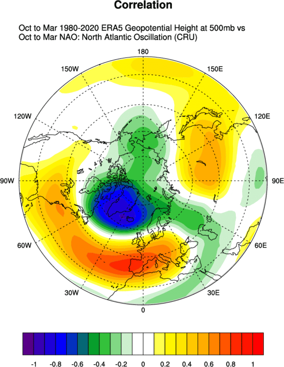
We can see that the positive NAO features a strong region of low pressure in the North Atlantic and higher pressure south in the Azores region and western Europe. This pattern amplifies the jet stream and sends the mild Atlantic airmass into the European continent and the southern United States. The image below from daculaweather shows the positive NAO weather response.
This limits winter potential over Europe as it is pushing the colder polar air up to the northeast, away from the continent. This is also a pattern with many strong windstorms over northern Europe. On the other side of the Atlantic, it can actually be beneficial for Canada and the far northeastern United States, as the cold air is being pulled from the north on the backside of the low-pressure systems.
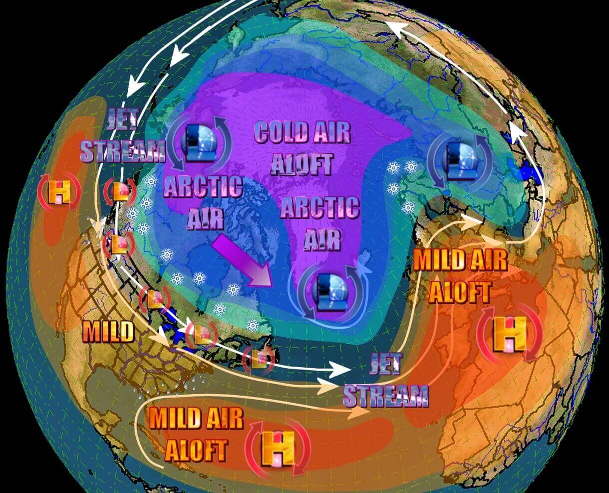
In a negative NAO, we usually have a blocking high in the North Atlantic and into Greenland. Low-pressure systems travel around it, creating an active cold air transport from the polar regions. A strong negative NAO is what every winter lover wants to see in the central and eastern United States and in Europe. The graphic below is by daculaweather.

For a better representation of how the weather patterns, we produced a video that shows the weather circulation in the Northern Hemisphere. You can nicely see the circulating mass of colder air over the polar regions. Also, notice how the weather patterns are developing over different continents, but stay connected in this larger system that spins around the Northern Hemisphere.
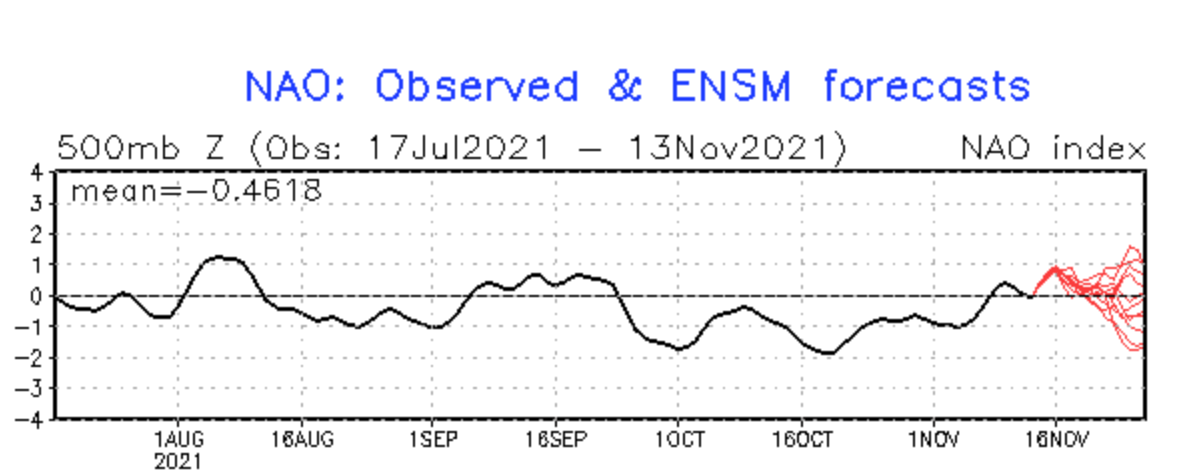
Current NAO forecasts show it to be weakly positive to neutral. In the second half of the month, we have a divided forecast, with a stronger tendency for a negative NAO pattern.
FALL 2021 SO FAR
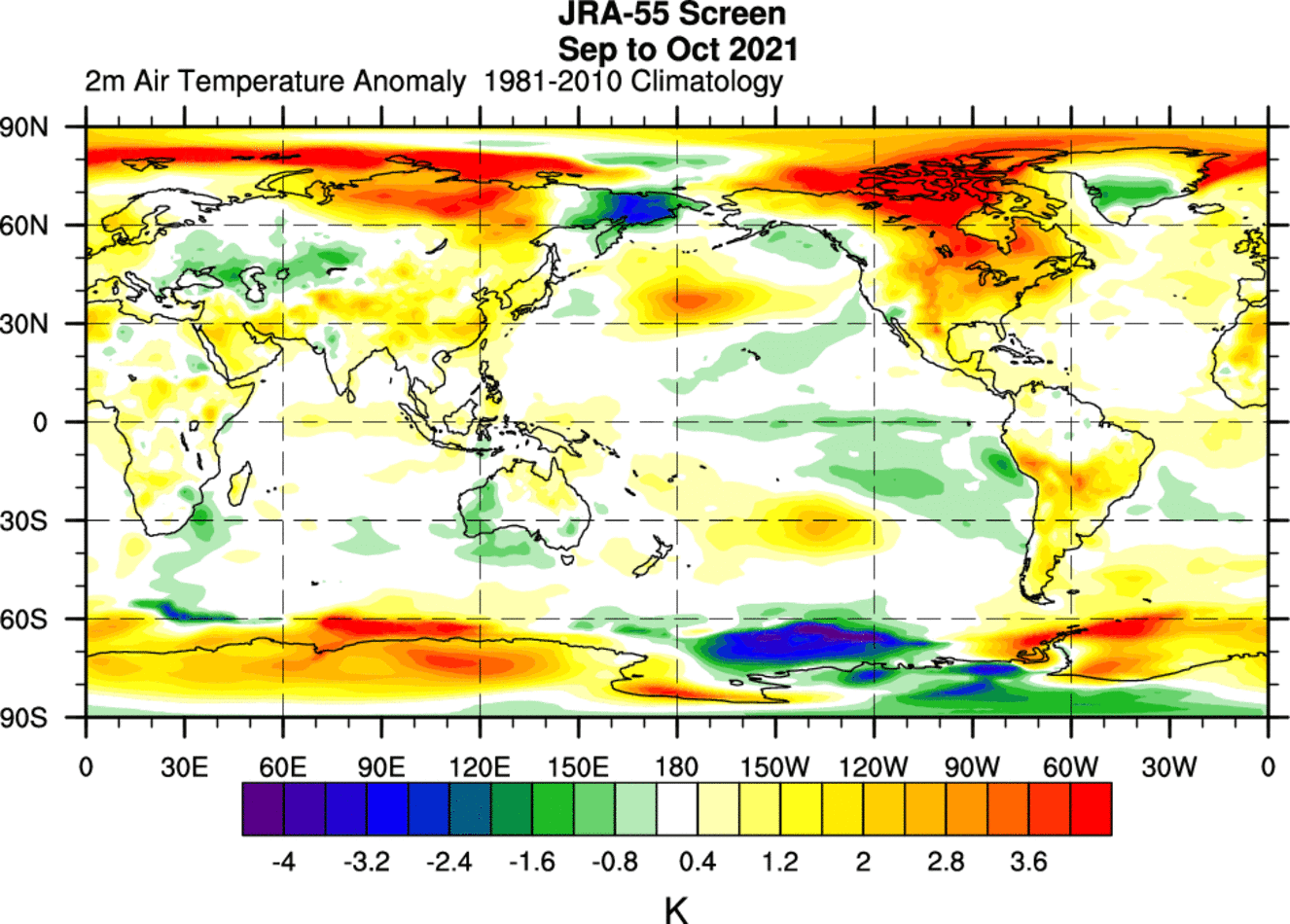
So far this Fall, we have mainly seen a positive to neutral NAO pattern on average. The image below shows the pressure pattern in September and October. There is a strong high-pressure system in eastern Canada, with a lo-pressure zone over the Aleutians and western Canada.
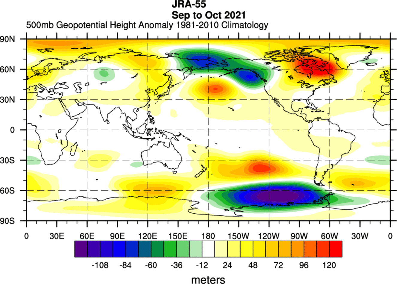
This causes a strong southerly flow from the United States up into Canada, extending into the Polar Circle. As you can see on the image below, we had strong warm anomalies over Canada and in the Polar Circle, due to the warmer than normal air mass being transported towards the north.
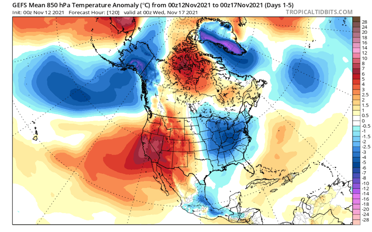
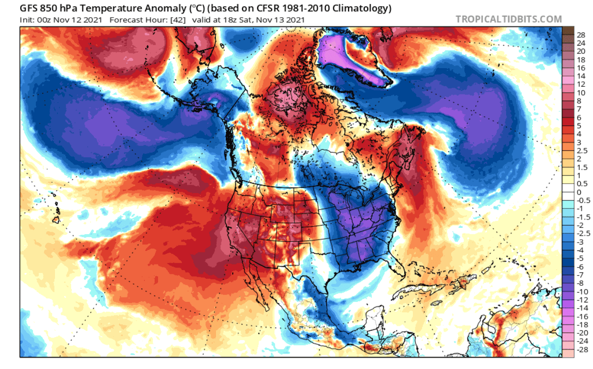
Currently in November so far, we still have warm anomalies over the western United States, Canada, and polar regions. But we are starting to see colder than normal air descending towards the southeastern United States and western Europe.

NOVEMBER WEATHER – SECOND HALF BEGINS
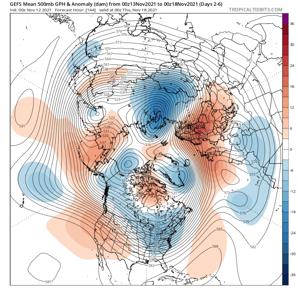
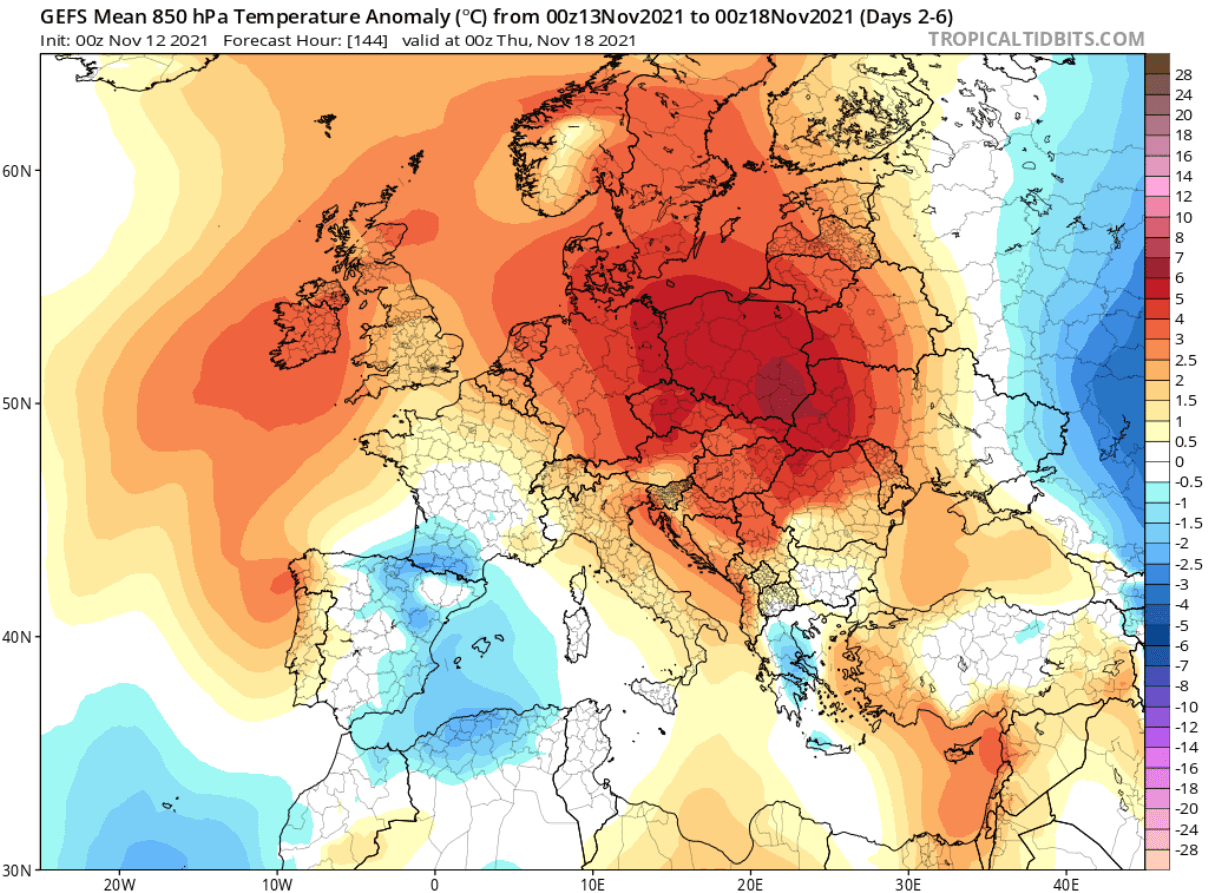
The second half of November will begin with a shift in the pressure pattern. We can see on the image below that a low-pressure zone now extends from western Canada down into the eastern United States. Over Europe, a high-pressure area is present, bringing mostly stable weather into the region.
Looking closer at Europe, we can see the warmer than normal temperatures under the high-pressure system. Some cooler than normal temperatures are likely in southwestern Europe under a cut-off low-pressure system.
Going directly to North America, we can see much warmer than normal temperatures in the western United States and central-north Canada. Colder than normal temperatures will prevail over Alaska and over the eastern United States, as a low-pressure system descends, moving out into the Atlantic.
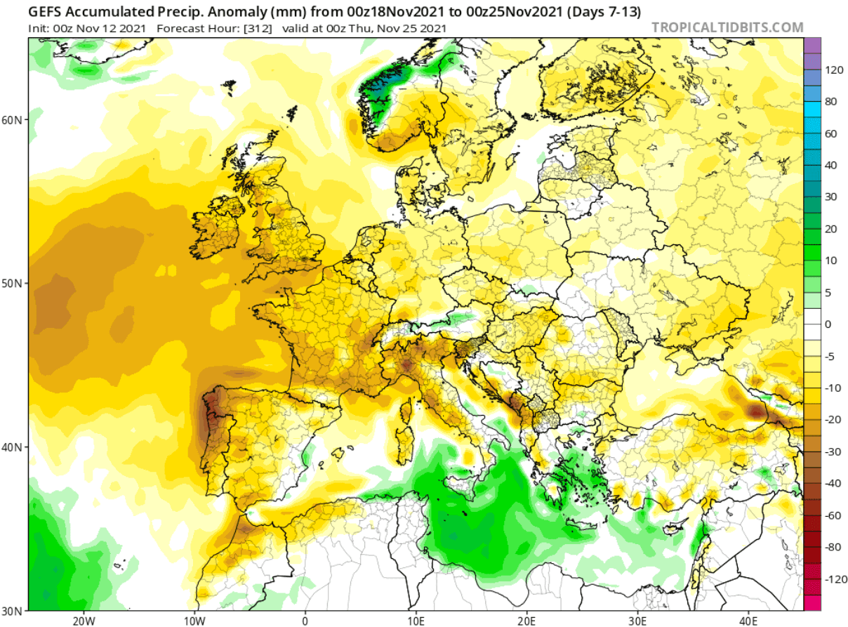
Precipitation-wise, most of the second half of November will be drier than normal over Europe. An exception is the southern Mediterranean with the cut-off low-pressure system.
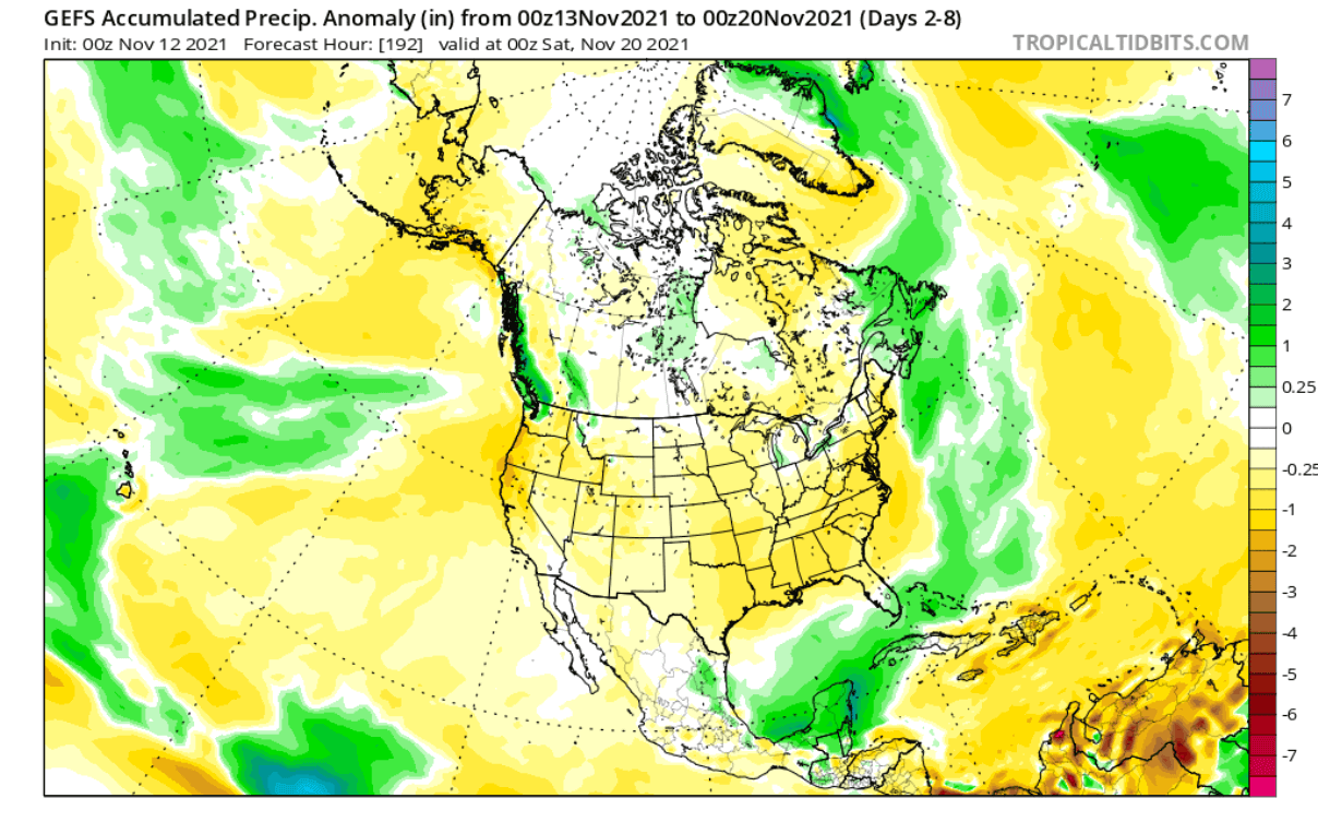
Over North America, we can also see drier conditions taking over much of the United States. The western half is under a high-pressure system and stable weather, while over the east, the colder airmass is also mostly dry, with average precipitation at best on the larger scale.
Looking closer at this weekend, you can see the pressure pattern below, with the high pressure in the west. A strong low-pressure area has descended down into the eastern half, creating a strong northerly flow down from Canada.

The colder than normal temperatures can be seen over most of the eastern United States, while the western half of the country is under more stable and warmer weather in the high-pressure area.
ECMWF NOVEMBER WEEK 3 FORECAST
As a contrast, we tend to use the ECMWF weekly forecast, to try and find a confirmation to the main general forecast. The pressure forecast for week 3 of November also shows the high-pressure over Europe and the western United States. A low-pressure zone with colder air is descending into the eastern United States. An important feature for the general circulation is also a high-pressure zone over eastern Siberia.

We can see the same temperature pattern also on the ECMWF weekly forecast, with warmer than normal conditions over the western United States and the colder air descending down into the eastern United States. It is sourced from western and southern Canada, by the established north-northwesterly flow between the two opposite pressure systems in the west and east.

The precipitation forecast from the ECMWF weekly trend also shows drier than normal conditions over most of the continental United States, with drier stale air in the west and drier colder air in the east.
A summary for weather at the beginning of the second half of November is that in Europe we will see a high-pressure system over the mainland. This means mostly warmer than normal to neutral temperatures, with less precipitation than normal.
Over North America, we will see a very dynamic pattern with high pressure over the western United States and a low-pressure area in the east. This will create a more northerly flow, transporting colder and drier air into the eastern United States, while warmer and stable conditions will prevail in the western half of the country.
NOVEMBER WEATHER FORECAST – WEEK 4 START
The weather forecast for week 4 shows some progression. The high-pressure area over eastern Siberia is getting stronger. Over Europe, the high-pressure area is pulling back towards the west. But over North America, the low-pressure zone remains over western and southern Canada, extending down into the northern United States.

This is shaping up to be a more neutral NAO pattern, with a long-term tendency for a negative NAO pattern, depending on the movement of the high-pressure area towards the Northern Atlantic.
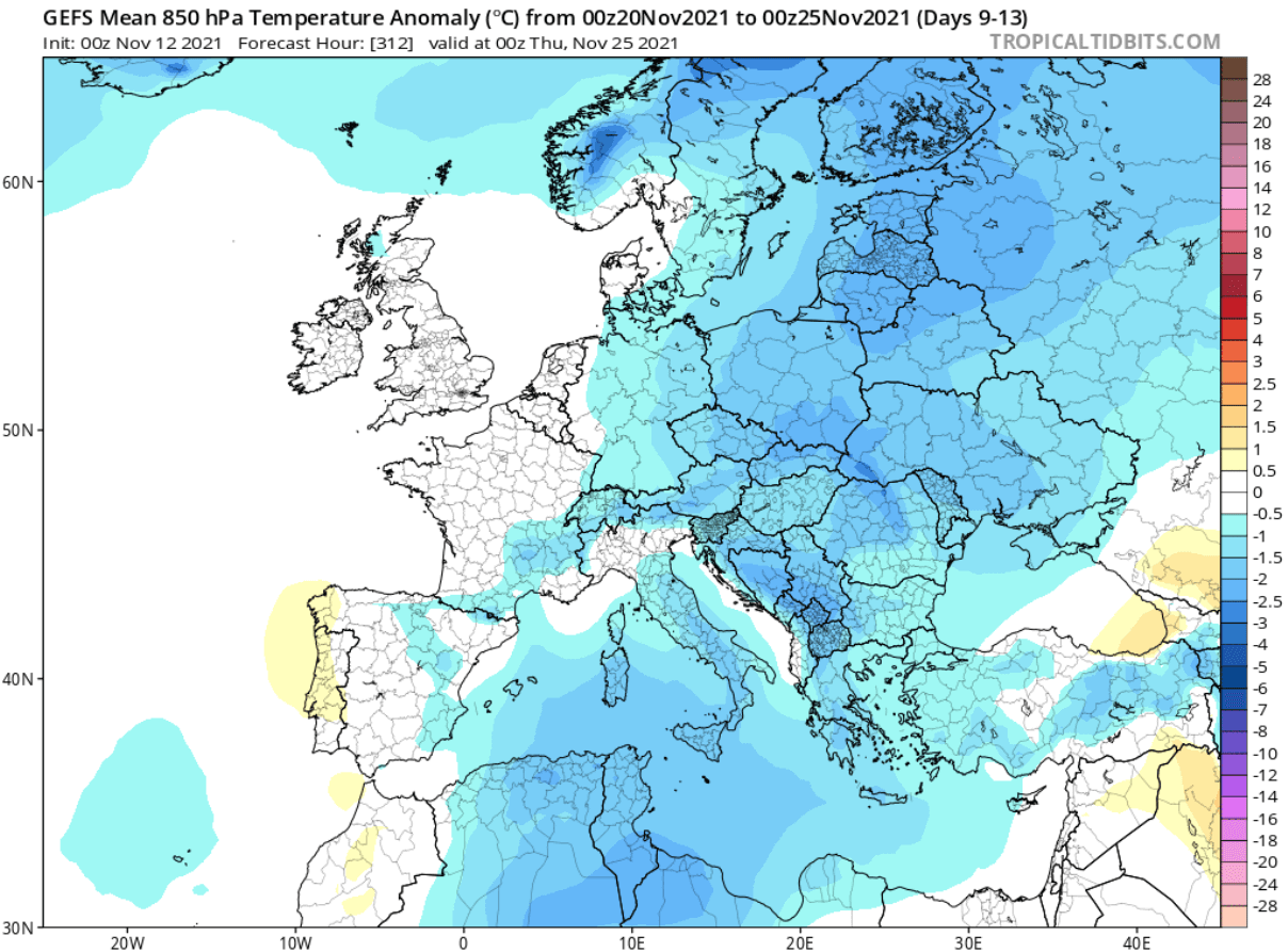
As the high-pressure area moves further west over Europe, that allows the low-pressure area to expand into northern Europe. That allows for a more northerly flow down into the central and especially eastern parts, with colder than normal temperatures, but drier conditions.
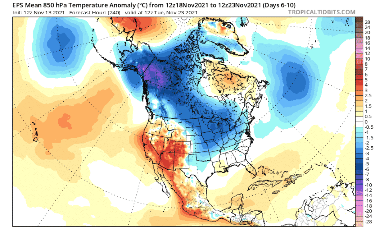
Over North America, we can see the warmer temperatures still prevailing over the western United States. But a strong region of colder than normal temperatures is growing over Alaska and western Canada. The low-pressure area extending into the northern United States does allow for the northerly flow to persist. That will likely send a new round of colder than normal weather down into the eastern United States.
We can see the drier than normal conditions persisting over most of the United States and eastern Canada. More precipitation is expected over the southern and northeastern states, with more available moisture.

END OF NOVEMBER (THANKSGIVING WEEK) WEATHER
Going into the final days of November, we have thanksgiving week. The pressure pattern looks to remain fairly stable, with a high-pressure system now present over the North Atlantic and southern Greenland, extending into northwestern Europe. This looks more like a negative NAO pattern at this stage.
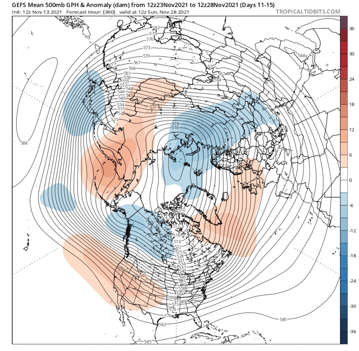
The low-pressure area remains over western and southern Canada, keeping the northerly flow active for northern and eastern United States. The Western United States remains under a high-pressure system and stable weather conditions.
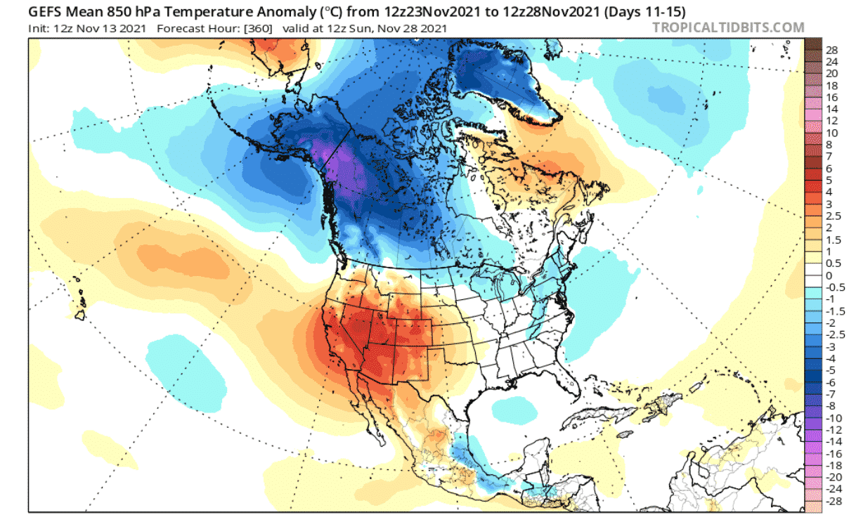
Looking at the temperature pattern for North America, we still have the cold region over western and southern Canada. That acts as a source of colder than normal air, which can be easily transported into northern and eastern United States, as soon as a low-pressure system can descend down into northeastern and eastern United States.
Looking at the snow forecast for the next 16-days, it has to be taken with a pinch of salt, as the forecast period is quite long. But it does show the tendency for snowfall over the higher regions in the western United States, and over the northern/northeastern parts of the United States. This does not show actual snow accumulation on the ground, but just snow precipitation.

ECMWF END OF NOVEMBER FORECAST
Adding the ECMWF model, it shows a similar pattern, with higher pressure over western Europe and the low-pressure zone over Canada, extending into the northern United States.

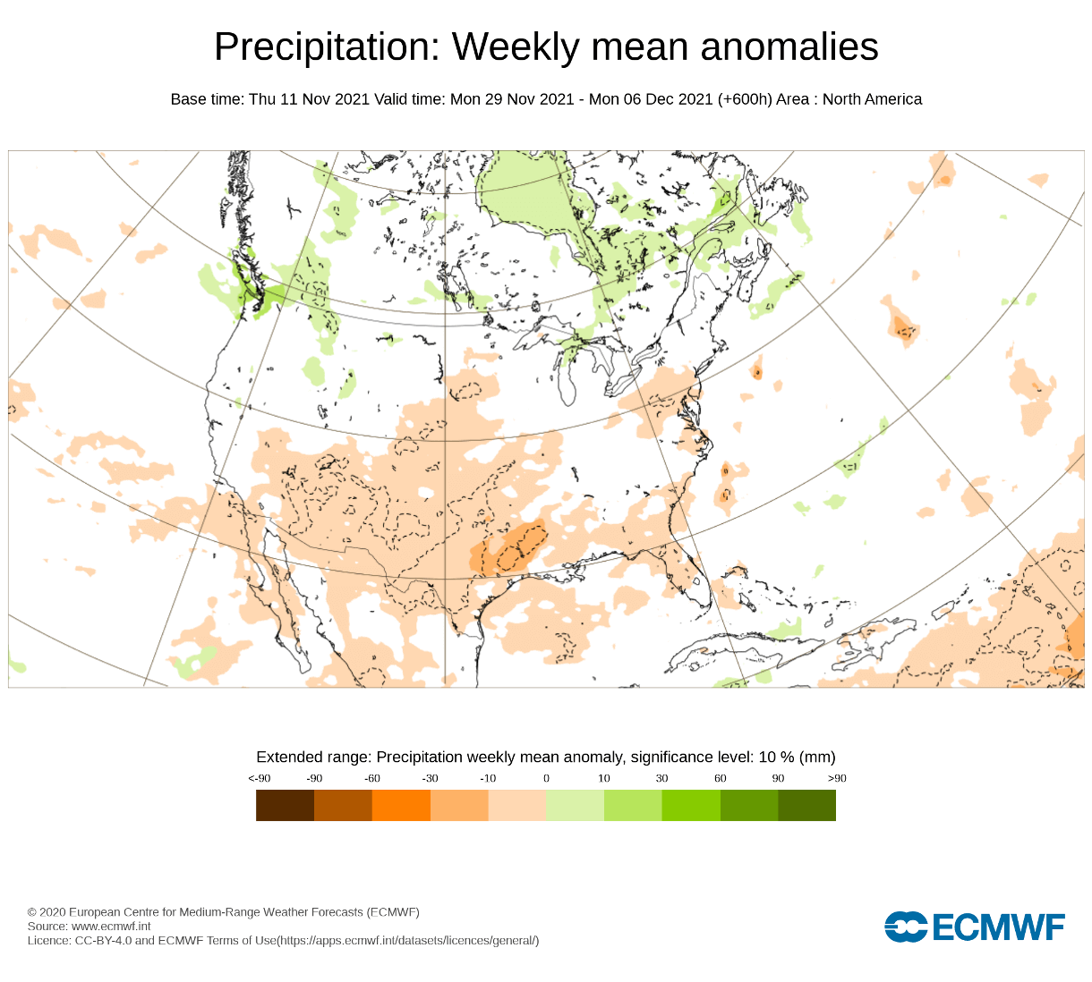
Over North America, the ECMWF is forecasting warmer conditions in the western United States. However, we can see the colder than normal temperatures extending down from Canada into the northeastern regions of the United States. This is an extended range forecast, so the actual extend of colder anomalies can be much greater/stronger. But we are looking at weather trends, which shows the quite persistent pattern over North America.

Precipitation-wise, we now see less dry conditions and more neutral precipitation over the central and eastern United States. But wetter conditions are indicated for southern states, with more available moisture. Western Canada is also under more precipitation, due to the moist westerly flow from the North Pacific ocean.

NOAA UNITED STATES WEEKLY FORECAST
The official 8-14 day forecast from NOAA nicely outlines the model forecasts that we have seen above. Warmer than normal conditions over the western United States, with colder than normal conditions over the eastern half of the country.

Precipitation-wise, we have drier conditions under the high-pressure system in the west. But more precipitation is expected in the southeastern states and along the east coast. More precipitation is also indicated for the northern states.
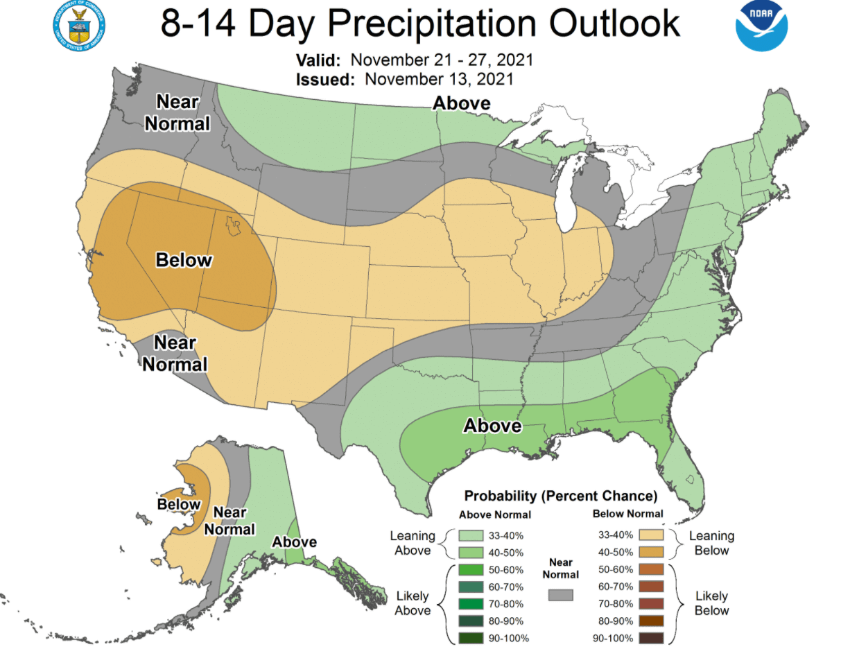
To summarize, the thanksgiving week weather forecast currently shows a colder weather trend for the eastern half of the country, while warmer and stable conditions are expected to persist over most of the western United States.
WINTER SEASON BEGINS WITH DECEMBER
Peaking into the start of December, we see a new pattern adjustment. The low-pressure zone over Canada is shown to be strong and stable, creating a more positive NAO pattern. That means the stronger circulation can lock the colder air further up north, making it harder to reach the mid-latitudes.

Over North America, warmer and stable conditions still persist over the western United States. Colder conditions remain in western Canada and Alaska. That still provides a source of colder air for outbreaks down into the northern and eastern United States. The forecast shows neutral temperatures in those regions, which is actually a hint of some scenarios driving down the colder air, similar to what we are seeing now and in the coming two weeks.

Precipitation forecast shows mostly drier than normal conditions. More precipitation is expected in the northwestern United States on the westerly oceanic flow which is typically a good source of moisture.
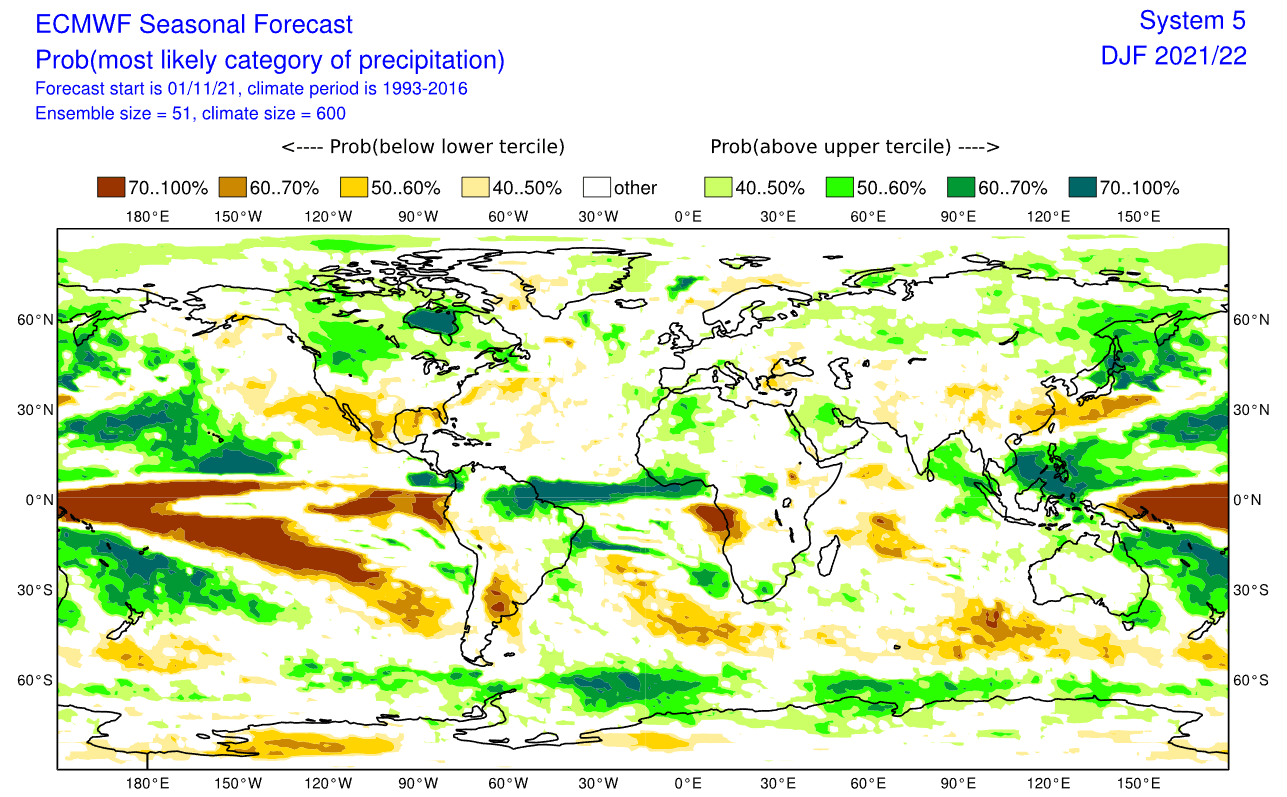
WINTER SEASON 2021/2022 LATEST FORECAST
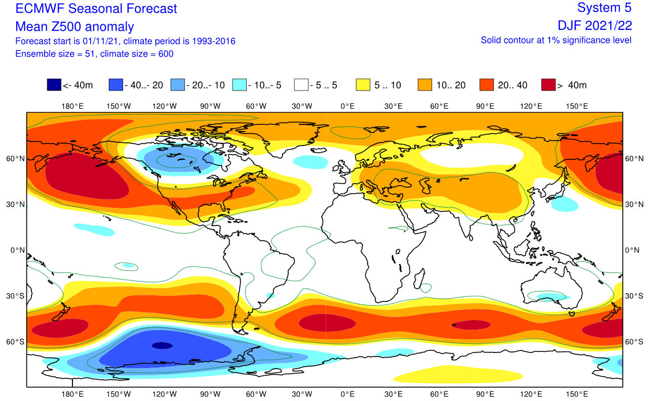
Looking at the winter season forecast below from ECMWF, we can see the strong high-pressure system in the North Pacific, typical for a La Nina winter. A low-pressure system is developed over western Canada and the jet stream is bending in between the two pressure systems.
We also see the North Atlantic in a somewhat positive/neutral NAO mode, which means an amplified jet stream over the British Isles and northern Europe. But this is not a typical positive NAO setup and shows a lot of variability over the winter season. It allows for winter situations over Europe. Most likely if the high-pressure system in the central Atlantic can crawl further up north, blocking the jet stream and creating a more northerly flow into Europe.
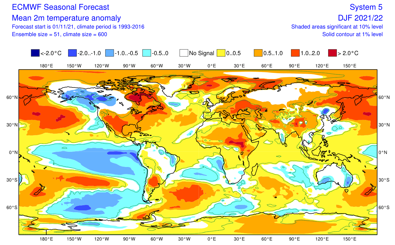
The temperature forecast below shows North America divided into two parts. Western and central Canada is forecast to be colder than normal, with a high chance of the colder air extending towards the parts of the northwestern United States and over the Midwest. The Southern United States is forecast to be warmer than normal.
Europe also features higher than normal temperatures, but with more over the eastern parts. Tho a more westerly flow dominant scenario is suggested, the pressure pattern does allow for a break in the flow. Occasional cold air from the northwest is possible down into the central and western parts.
Precipitation anomaly forecast shows a more classic La Nina type pattern over Canada and the United States. We see the mainland United States having wetter conditions in the northern parts under the jet stream. Drier conditions prevail in the south-central regions.
We will release regular weekly and monthly updates for the upcoming cold season as fresh forecasts are produced, including an updated Winter Forecast, so make sure you bookmark our page. Also, if you have seen this article in the Google App (Discover) feed, click the like button (♥) there to see more of our forecasts and our latest articles on weather and nature in general.
SEE ALSO: The First Major Winter Storm of the Season Delivered Significant Cold Into Central United States This Past Week.