A dramatic summer-killer pattern is taking shape across Europe this week, bringing a sharp end to the prolonged early-September Heat Dome. A powerful upper-level trough that is emerging from the North Atlantic will drive a strong surface cold front across Western and Central Europe by mid-week, crashing directly into the extreme, record-warm air mass parked over the continent.
This volatile clash will trigger a widespread severe weather outbreak from the Alps down into the Western Balkans, fueled by an extremely unstable air mass and a sheared environment, followed by a sharp drop in temperatures as unseasonably cold air surges in behind the frontal boundary.
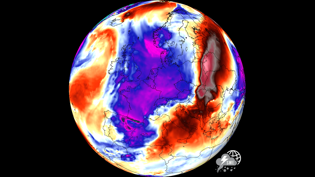
The transition begins Wednesday into Thursday as the high-amplitude ridge breaks down under intense upper-level forcing. As the front pushes east, extreme atmospheric instability, high moisture content from the historic Mediterranean marine heatwave, and strong vertical wind shear will combine to fuel severe thunderstorms across Eastern France, Switzerland, the Balearic Islands, Northern Italy, Austria, Slovenia, and Croatia.
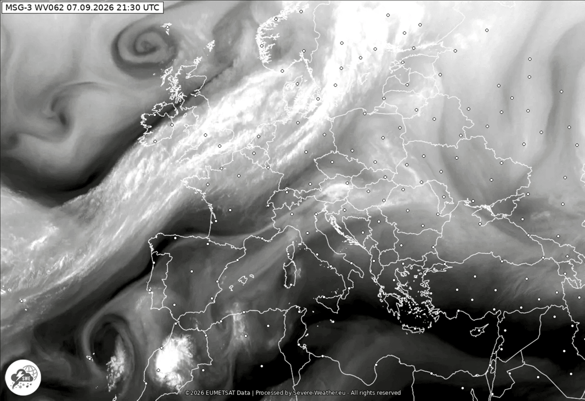
Primary convective threats include large to giant hail, severe damaging winds, torrential rainfall with flash flooding, and localized tornadic potential. On Monday night, the frontal boundary was analyzed as entering Western Europe, extending from the deep low over Scandinavia toward the Azores.
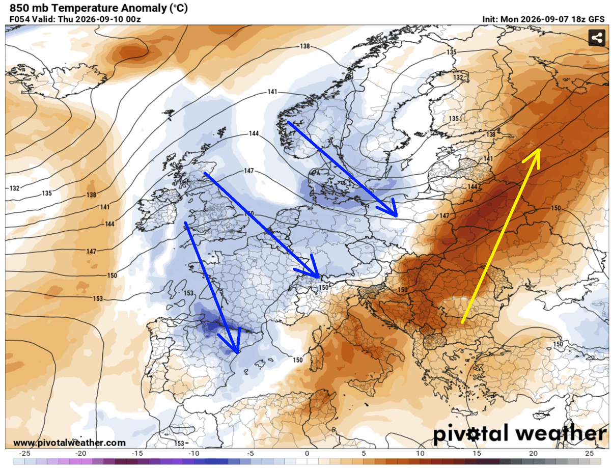
Behind the frontal boundary, a polar-origin air mass will overspread Central Europe, bringing a drastic thermal collapse. Daytime highs that previously hovered near 35–40 °C will plummet by 15 to 20 °C in less than 24 hours. The rapid cooling will bring the first heavy snowfall to the higher elevations of the Alps, while cold continental winds lower snow lines across high-mountain passes and deliver a crisp, autumn-like atmosphere across Western and Central Europe heading into the weekend.
Forecast model animations below illustrate the progression of the deep upper trough and the advancing surface cold front, highlighting the sharp temperature gradient and severe convective potential moving from the Alps into the Western Balkans.
Let’s dig into the details of this significant pattern change that ended the historic early September heatwave mid-week.
Synoptic Setup: Heat Dome Collapses as Deep Upper-Level Trough Enters West-Central Europe
The general weather picture over the North Atlantic and European continent this week indicates that a strong upper-level ridge is finally collapsing the prolonged Heat Dome, ending the excessive heatwave. A large upper-level wave is emerging into Western Europe on Tuesday, spreading east on Wednesday and Thursday, centered over Northern Europe.
A secondary wave cuts off into the Northern Mediterranean, producing a surface low that travels across Italy toward the Western Balkans and supports widespread severe weather activity.
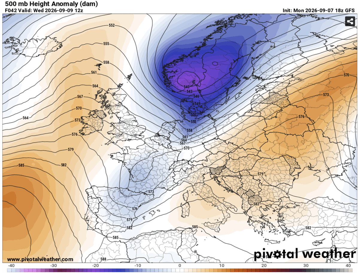
The warmest air mass trapped beneath the core of the heat dome is finally washed away as the wave emerges from the west, gradually but rapidly spreading cold air into central Europe on Wednesday.
The hottest air mass will be pushed ahead of the wave into Eastern Europe and western Russia until Friday. This is the summer-killer pattern, which usually means prolonged, intense heat is flushed out by a much colder air mass, flipping the pattern from warm to cold.
The meteogram chart clearly shows how sharp the summer-killer pattern cold front will be over the coming days. While the first week of September starts with hot temperatures, much warmer than normal, there’s a significant drop mid-week.
From nearly 18-20 °C at 850 mbar levels, about 10 degrees above long-term normals, the temperature drops by around 15 °C in about 24 hours. The air mass will change significantly. The bottom part of the chart also hints at significant rain on Wednesday and Thursday across the Northern Mediterranean; the chart is for Ljubljana, Slovenia.
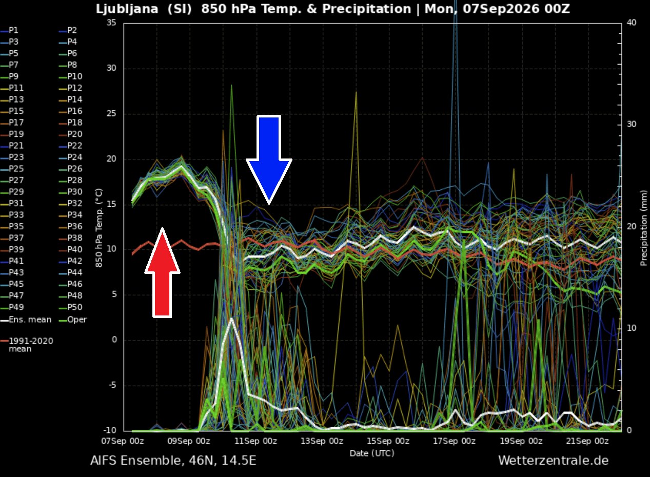
With a much colder air mass arriving while the existing Mediterranean marine heatwave doesn’t get flushed away easily, conditions remain unstable and autumnish as the pattern flips mid-week.
Much-needed rainfall and refreshment will spread across large parts of Europe until early next week.
Two-Day Severe Weather Outbreak and Significant Rainfall Across the Northern Mediterranean
As the upper wave emerges towards Central Europe, the high-pressure and temperature difference against the departing heat dome amplifies the jet stream winds, expanding across the central parts of the continent into the Western Mediterranean. This establishes moderately strong wind shear across the warm sector and along the arriving cold front.
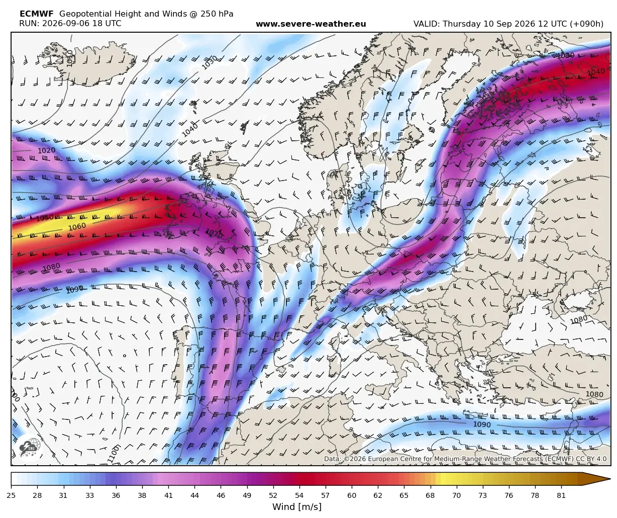
Thanks to the record-breaking marine heatwave over the Mediterranean, unseasonably high moisture is trapped over the region. This creates an extremely unstable air mass with CAPE exceeding 3000-4000 J/kg, fueled by significantly high dewpoints.
The air mass will support a volatile environment that will lead to extremely severe weather, with supercell and multicell storms delivering large to giant hail, torrential rainfall with flash floods, and tornadoes with severe wind threats.
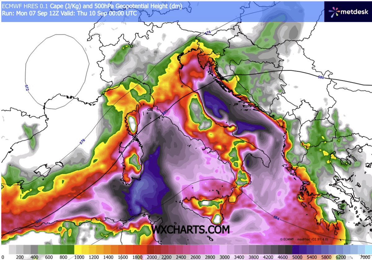
As the cold front enters the Alpine region, the secondary low forms over the northern Mediterranean, allowing the frontal system to slow down and intensify. The extreme instability and strong wind shear will combine starting Wednesday and continue through late Thursday.
Widespread severe weather activity is forecast across the Alps to the Western Mediterranean first, gradually advancing east-southeast Wednesday and reaching Central Italy, the Adriatic Sea, and the Western Balkans on Thursday.
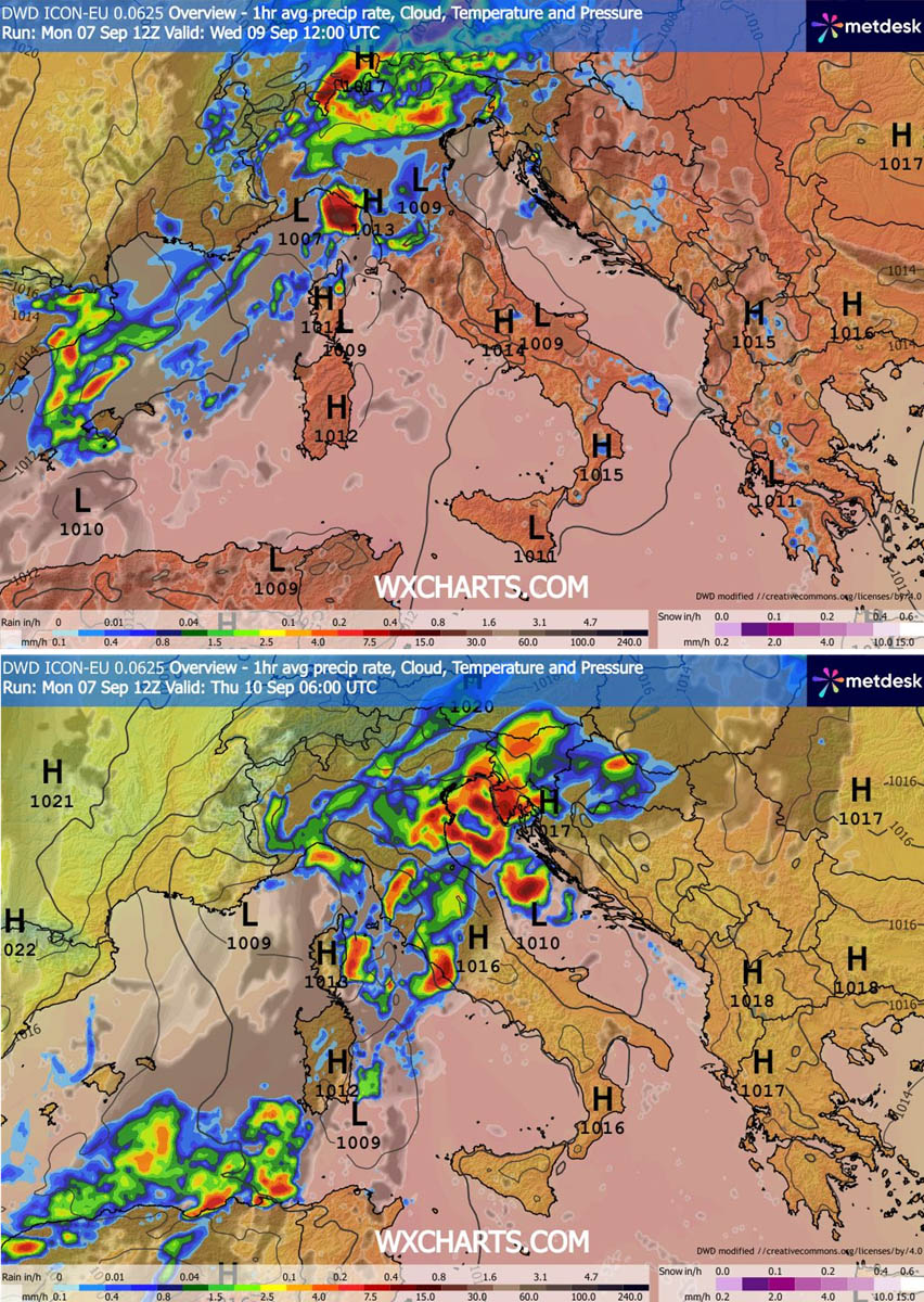
Expect multicell and supercell storms, with a particularly severe threat in those zones. Wednesday midday will support violent severe storms around the Balearic Islands, followed by widespread intense storms over Northern Italy into the North Adriatic through the afternoon and Wednesday night. Activity will continue into Thursday, with extreme instability, as a front moves into the Balkans.
High moisture content, extreme instability, and relatively slow-moving storms are expected to produce high rainfall amounts along Liguria Bay, the North Adriatic Sea, and the northwestern Balkans. Rainfall sums will locally reach 150-200 mm in two days, leading to potentially significant flash floods.
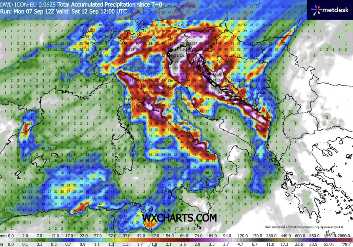
Intense storms will also tend to stall over local convergences and lead to a training-cell effect, supporting localized flash floods along the coastal areas of the Adriatic and Ligurian Bays and the Tuscany coast.
We will continue to monitor the evolution of the weather pattern and update the forecasts accordingly. Long-term trends suggest the pattern will remain more dynamic into mid-September. Stay tuned for updates.
PivotalWeather and WXcharts provided images used in this article.
See also:
Winter 2026/2027 Snowfall Predictions: New Data Shows a Strong Super El Niño Snow Pattern