We are live-tracking a widespread Tornado Outbreak across the Southeast U.S., with numerous violent, long-tracked tornadoes expected across Mississippi and Alabama Saturday afternoon and night.
NOAA’s Storm Prediction Center has issued a rare HIGH RISK where a tornado outbreak is expected across the central Gulf Coast States and Deep South into the Tennessee Valley.
Significant tornadoes, some of which should be long-track and potentially violent, are expected Saturday afternoon and evening hours, extending into Saturday night as the system tracks east.
The most dangerous tornado threat should begin across eastern Louisiana and Mississippi from late morning to afternoon, spread across Alabama late into the evening, and reach western parts of the Florida Panhandle and Georgia tonight.
Note: This post is regularly updated as the system evolves. The most recent update is always at the top of the article. Feel free to bookmark the link and stay tuned.
UPDATE #5: Large convective cluster with embedded severe thunderstorms visible on satellite
Issued at March 15th, 22:00 UTC
An impressive water vapor satellite view across the Contiguous U.S. this afternoon. Notice a deep low centered above the deep South, with a large quasi-linear cluster of severe thunderstorms moving across Mississippi into Alabama and Tennessee.

While the core of the low drags across mid-Mississippi Valley, the storms will advance due east across Alabama and Georgia overnight into early Sunday.
UPDATE #4: 16 tornado reports for now; outbreak continues across east-southeast Mississippi into western Alabama
Issued at March 15th, 21:10 UTC
So far this afternoon, intense supercells have produced a few strong, damaging tornadoes across southern Mississippi and western Alabama, along with 46 severe wind and 16 significant hail reports.

The most violent and destructive tornado was observed in Tylertown, MS.
At least three fatalities and multiple injured have been reported.
UPDATE #3: Numerous tornadic supercells across eastern Mississippi
Issued at March 15th, 18:15 UTC
A quasi-linear convective system (QLCS) is ongoing across Mississippi early this afternoon, with numerous severe discrete supercell thunderstorms. Multiple tornadoes have already been reported.

Storms will increase in coverage and intensity in the following hours as even more favorable conditions develop for these storms to emerge into.
A violent, long-track tornado threat will develop, with the highest potential from southeast Mississippi into west-central Alabama through the evening hours.
UPDATE #2: Particularly Dangerous Situation (PDS) Tornado Watch 46 issued for Western, Central, and Northern Alabama, and Southeast Mississippi
Issued at March 15th, 17:30 UTC
The NWS Storm Prediction Center has issued a Tornado Watch for portions of western, central, and northern Alabama and southeast Mississippi.
Effective this Saturday afternoon and evening from 1225 PM until 800 PM CDT.
THIS IS A PARTICULARLY DANGEROUS SITUATION…
Primary threats include…
- Numerous tornadoes and several intense tornadoes expected
- Scattered damaging winds and isolated significant gusts to 75 mph likely
- Scattered large hail and isolated very large hail events to 2.5 inches in diameter likely

Intense supercells capable of producing numerous tornadoes will spread eastward from Mississippi into Alabama this afternoon and evening. Given the very favorable environment, multiple intense to potentially violent tornadoes (EF-3/EF-4+) appear possible.
Clusters of thunderstorms and embedded supercells will also pose a threat for severe/damaging winds of 60-75 mph, and large hail around 1.5-2.5 inches in diameter.
UPDATE #1: Particularly Dangerous Situation (PDS) Tornado Watch 45 issued for Eastern Louisiana and Mississippi
Issued at March 15th, 15:45 UTC
The NWS Storm Prediction Center has issued a Tornado Watch for portions of Eastern Louisiana, Mississippi, and Coastal Waters. The watch is effective this Saturday morning and evening from 10:30 AM until 600 PM CDT.
THIS IS A PARTICULARLY DANGEROUS SITUATION…
Primary threats include…
- Numerous tornadoes and several intense tornadoes expected
- Scattered damaging winds and isolated significant gusts to 75 mph likely
- Scattered large hail and isolated very large hail events to 2.5 inches in diameter likely

Multiple supercells are expected late this morning through early evening from eastern Louisiana into much of Mississippi. With a favorable environment, numerous tornadoes are expected, including the potential for multiple intense to violent tornadoes (EF3-4+).
As these thunderstorms move northeastward, scattered large hail up to 1.5-2.5 inches in diameter and damaging winds of 60-75 mph will also be a threat.
Saturday’s morning satellite reveals that intense storms continue east across the south, with a substantial moisture influx from the Gulf of America northwards ahead of the storm clusters. This is a typical view when tornado outbreaks occur.
Mississippi, Louisiana, and Alabama will be in the prime zone for hazardous storms over the next 24 hours.

The video animation below provides a quick overview of the storm dynamics across the Southeast U.S. this weekend.
Violent severe thunderstorms will rapidly develop along the leading frontal system from west to east, grazing into an unstable warm sector.
Let’s examine the details of the weather system related to a large Winter Storm that is moving across the CONUS this weekend. Tens of millions along the storm’s path will experience significant weather conditions, with a destructive tornado outbreak forecast across Mississippi and Alabama this afternoon and evening.
A deep wave emerged across the U.S. and developed a significant winter storm
A significantly deep upper wave has emerged into the United States, with its core digging far south to the Gulf Coast on Saturday. It will move east-northeast this weekend.

An associated winter storm blasted across the Plains and Midwest Friday night, causing damaging dust storms across Texas and Oklahoma. The storms caused rapid wildfires in extreme 80-100 mph winds.
The visible satellite analysis from Friday afternoon reveals the storm’s development; the central pressure peaked near 978 mbar. Ahead of the low, a large warm sector is spread across the Southeastern U.S., with a significant warm and moist airmass advection from the Gulf of America.

Later during the day, the low matured, and the major duststorm was evident on the visible imagery, blasting from Texas across Oklahoma and Kansas towards the center low further north. Numerous road accidents were reported.
Severe thunderstorms first developed along the leading front across Eastern Nebraska, Iowa, and Missouri.

Widespread severe thunderstorms developed, followed by several strong tornadoes across the mid-Mississippi Valley into the evening and night hours. Destructive tornadoes were reported with intense supercell storms in Missouri, Illinois, and Arkansas.
Meanwhile, the air mass continued to destabilize across the Southeast Friday night and continues this morning.

This Saturday, the upper wave’s further eastward progress results in a particularly dangerous weather setup across the South and Southeast U.S. as a powerful upper-level jet stream grazes into a volatile unstable air mass underneath.
This will provide a widespread storm initiation from Louisiana and Arkansas across Mississippi and Tennessee to Alabama into the evening and night hours.

A significant tornado outbreak is expected for the Southeast states
Today, a volatile environment has been established for the Southeast U.S., with a significantly deep upper wave and a surface frontal system.
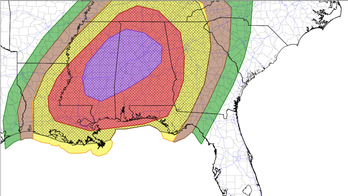
A HIGH RISK has been for central and eastern Mississippi into the north-central Alabama, with a Moderate Risk surrounding the High from central Louisiana to Tennesee and western Georgia. Widespread and intense storms are expected from the afternoon into the evening hours.

The storm’s evolution once the upper wave digs into the unstable air mass will be rapid and violent, thanks to overlapping near-ideal conditions. Expect widespread storm coverage, moving east with time from midday into Saturday night.
The High-Risk area includes the major cities of Jackson, MS, and Birmingham, AL. The hatched area indicates where EF2 or stronger tornadoes could occur.

The following chart is a genuine concern. It reveals potential storm tracks of the most violent supercell thunderstorms. The updraft helicity swath map indicates where the rotating storms could develop.
This shows how widespread the severe thunderstorm coverage will develop, with potentially numerous tornadic supercells ongoing simultaneously. Storms will generally be moving from southwest to northeast.

From a more technical side, here is the vertical skew-T diagram for central Mississippi Saturday afternoon. It is a highly volatile environment, with textbook hodographs indicating powerful winds throughout the atmosphere.
Winds are veering with height, creating intense wind shear and helicity. This is a textbook environment when violent supercell thunderstorms with strong, long-tracked tornadoes typically occur.

Nearly 500 m^2/s^2 of 0-1 km storm-relative helicity, coupled with 3000 J/kg of surface-based CAPE and 80 knots of effective wind shear, is extreme. Conditions like this are rare and could lead to deadly, destructive tornadoes.
With high moisture spreading across the warm sector, intense rainfall and flash floods will be an additional threat from the storms. Weather models suggest 3-5 inches is likely across northern Mississippi and Alabama until Sunday afternoon.

We are live-tracking the evolution of the ongoing tornado outbreak and will update you accordingly. Stay tuned. The most recent updates are at the top of the article.
Wxcharts, Windy, WeatherBell, and Pivotalweather provided images used in this article.