The new Summer 2025 predictions show an interesting pressure pattern in the atmosphere over North America. What stands out is a low-pressure area over Canada, with an extension forecast towards the eastern parts of the United States, bringing a disturbance in the weather pattern over the country.
With the cold La Nina and the Polar Vortex now being out of the picture in the long-range, there is no clear main driver behind this pattern in the forecast. So the atmosphere will take more of a path of its own.
As we look at the latest long-range forecasts, we do have to keep in mind that these are still not fixed scenarios. But they give us a good idea of the model predictions for Summer 2025 over the United States and Canada.

FROM WINTER TO SUMMER
Before looking at the summer predictions, we will first look at the latest analysis for Spring. Meteorological spring covers the March-April-May period, and we currently have data from March 1st to May 21st, so that covers a large part of the season.
The 3-month pressure anomaly analysis for this period shows a low-pressure area over Canada and a low-pressure tendency into the central United States. A low-pressure zone in this area likely results from a stratospheric warming event in March. A high-pressure zone was present over the eastern and northeastern United States.

You can also see a high-pressure anomaly in the northern Pacific, and far north in the Polar Circle. These high-pressure anomalies are at least partially driven by the cold La Nina in the Pacific and the collapse of the Polar Vortex in early March.
Looking closer at the temperature pattern in this period, you can see the larger area of warm anomalies over the central and eastern United States. A cold air anomaly was present over Canada, with occasional extensions into the United States.

The precipitation analysis shows that most of the central and eastern United States saw more precipitation than usual. This was mainly the result of the low-pressure systems over the western and central United States, bringing unsettled weather into the central and eastern United States.

Overall, we can see the Winter-Summer transition was quite vibrant across the United States: more stable/drier conditions over the western U.S., with lower pressure bringing more rainfall and unsettled weather into the central and eastern parts.
One of the atmospheric players that will slowly lose its influence in the Spring is the outgoing La Niña anomaly in the Pacific Ocean.
ATMOSPHERIC ANOMALIES
The La Niña we mentioned is a cold phase of the ENSO anomaly, which stands for “El Niño Southern Oscillation.” This is a region of the Pacific Ocean that periodically shifts between warm and cold phases. Typically, there is a phase change around every 1-3 years.
Below is the ocean analysis from early March, with the main ENSO regions marked in the image. You can see that colder-than-normal waters were still present across the central Pacific region, a signature of the La Niña. But an unusually warm anomaly has emerged towards the eastern region, signaling its end.

A stronger cooling phase has been ongoing since early December. That has produced the still visible cold “wave” shapes, which are from the trade winds pushing the surface waters.
Another major turning point occurred in mid-March, as a Sudden Stratospheric Warming event (SSW) unfolded. As the name suggests, an SSW event is a rapid rise in pressure and temperature in the stratosphere. It collapsed the Polar Vortex circulation, impacting the weather patterns below for the weeks ahead.
Below is the mid-stratosphere (31km/18.5miles) analysis for mid-March. It shows the stratospheric high-pressure system (H) taking over the polar regions and splitting the Polar Vortex into two cores (L). This is the stratospheric warming even at its peak, with the warming wave completely taking over the mid-stratosphere.

Such a strong, warm anomaly can only be caused by stratospheric warming events. And this event was unusually strong for this time of year compared to previous early Spring SSW events.
For an even better visualization of what a Polar Vortex collapse looks like, we produced the video below. It shows the full 16-day sequence of the stratospheric Polar Vortex breaking down under the strength of the 2025 Stratospheric Warming event.
The stratospheric pressure anomaly has slowly moved downwards, impacting the weather patterns as it connects with the lower layers. Below is an image that shows the pressure anomalies across the atmosphere over time, at a longer period back to early March.

Negative values indicate lower pressure (blue anomalies), and positive values indicate higher pressure (red colors). We have altitude from the ground up to the top of the Stratosphere (~46km/28mi). You can see a strong high-pressure anomaly in the stratosphere from early March all the way into mid-April.
That large mass of high pressure is the stratospheric warming anomaly, and you can see how its impact slowly moved downwards to the weather layer (below 100-200hPa). It impacted the lower levels in waves of pressure disturbances, playing a role in the weather patterns.
Below is a composite image of a few events in the past weeks, when the pressure anomalies from the stratosphere connected downwards. You can see several different situations with a cold air release across the United States.
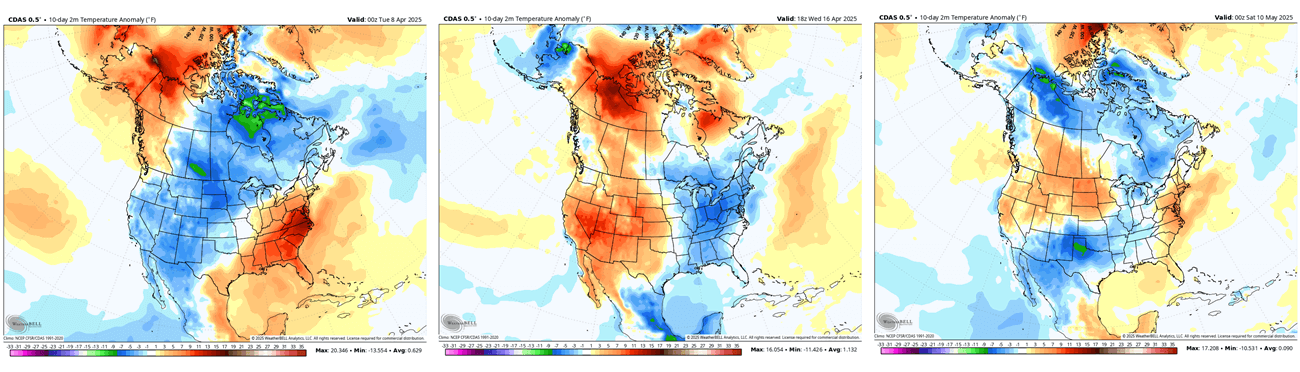
These are just 3 examples, but they show that despite an overall warm 3-month average, there were several events when colder than normal air swept across the United States and Canada, thanks to the stratospheric anomalies.
This brings us to the latest weather patterns and the forecast for the first month of the meteorological summer.
JUNE 2025 FORECAST FOR NORTH AMERICA
Because we have the extended range forecasting tools at our disposal, we can have a more detailed look at the June forecast, which is just around the corner. After this, we will look at the 3-month forecasts for the overall summer weather patterns.
Below is the pressure forecast for the first week of June. It shows a very interesting pattern, as we still have that low-pressure anomaly over Canada. And you can see an extension of that low-pressure anomaly into the eastern United States. Images by Weatherbell, using a commercial license.

At the same time, a high-pressure ridge is building over the western United States and the Pacific Northwest.
The temperature forecast for the same week shows below-normal temperatures over the south-central and eastern United States. This is because a low-pressure anomaly over the eastern United States creates a cooler northerly flow into the eastern half of the country.

Warmer than usual airmass will spread over the western United States and southern Canada, as a high-pressure area is extending from the south.
But looking at June overall as a whole month, you can see a low-pressure zone indicated over northern Canada, and a weak low-pressure disturbance over the eastern United States. But compared to week 1 above, you can see the high-pressure area extending also towards the eastern United States over the rest of the month.

Over Canada, we see no well-defined pressure anomalies. That indicates a more dynamic pattern over the country, with waves of high and low pressure systems passing over.
Looking closer at the whole June temperature forecast, you can see the normal to below-normal temperatures over the eastern United States and eastern Canada. A large part of this anomaly comes in the first half of the month, but if the pressure pattern is stable, it can limit the heatwave potential deep into June over the eastern United States.

The rest of the United States shows above-normal temperatures, especially over the northern, western, and west-central parts. Above-normal temperatures are also forecast over south-central Canada, while far western Canada and Alaska show below-normal temperatures in June.
The precipitation forecast also indicates increased moisture and clouds over the eastern United States, likely from the indicated low-pressure area. We see more rainfall over the eastern and southeastern United States for June and over parts of central and southeastern Canada.

Less rainfall than usual is forecast over the whole Plains, the northern and northwestern United States, and parts of western Canada.
LONG-RANGE FORECAST FOR NORTH AMERICA
We will examine the long-range trends from several different forecasting systems. ECMWF is statistically a better long-range model, so we usually start with its forecasts for the long-range predictions.
Because we have already shown the June 2025 forecast, we will focus on the July-August-September period in this long-range part.
The pressure forecast shows a low-pressure area over northern Canada, continuing from June. A high-pressure zone is forecast over the Pacific Northwest, extending towards the east. There is no low-pressure area forecast over the eastern United States, but we do see a potential low-pressure disturbance under the high-pressure belt.

Looking at the temperature forecast, you can see the area of reduced high-temperature anomaly over the eastern United States and the southeast. This indicates the likely presence of at least some type of a pressure disturbance, limiting the extended heatwave potential.

The strongest warm anomalies are forecast over the northern, western, and central United States, with above-normal temperatures also reaching into southern Canada. Northern Canada is forecast to have normal to below-normal temperatures under the low-pressure zone.
In the summer precipitation forecast, you can see less rainfall than normal is forecast over the western, central, and northern United States and southern Canada. More rainfall than usual is forecast over northern and western Canada.

But a special case is the above-normal rainfall anomaly over the eastern United States. Overall, it shows a more unsettled weather pattern, further indicating the presence of a pressure disturbance.
UKMO FORECAST FOR NORTH AMERICA
The second model of choice is UKMO. This model has been a good performer over the past years. It is a good complementary forecast to the ECMWF, with the actual weather conditions ending up somewhere between both models.
The UKMO pressure forecast also shows a low-pressure area over northern Canada, but pushed much further east compared to the forecast above. This enables the high-pressure area to expand much further over North America.

Looking at the temperature forecast, we decided to use the probability outlook. This shows where there is a potential area of weaker warm anomalies. And this model indicates the southern and south-central United States to show a lower probability for high warm anomalies.

The strongest warm anomalies are forecast over the western and northeastern United States, with above-normal temperatures also across southern Canada.
In the summer precipitation forecast, you can see less rainfall than normal is forecast over the central and northern United States and southern Canada. More rainfall than usual is forecast over the southwestern United States and northern Canada.

The southern and southeastern United States shows some tendency for normal to above-normal rainfall, indicating some form of a pressure disturbance.
NMME FORECAST FOR THE UNITED STATES AND CANADA
NMME is the North American Multi-Model Ensemble forecasting system, published by the CPC. This is a forecast that is produced from several different model predictions, merged into one final forecast. Such a system is usually useful to capture the prevailing weather trends in the forecast.
Below is the 3-month average pressure forecast for summer from the NMME prediction. It shows a dominant high-pressure anomaly over the northern United States and southwestern Canada. Above that anomaly, we see a tendency for a lower-pressure area, similar to the ECMWF.

Over the eastern United States, we tend to see a break in the high-pressure zone, which would mean a weaker warm air anomaly. This is likely a pressure disturbance that is frequent enough to still be indicated in the 3-month average forecast.
The NMME temperature forecast for the same period shows the highest chance of strong above-normal temperatures over the western United States, the upper Midwest, and the Northeast. Southeastern Canada also shows a higher chance of above-normal temperatures, while southwestern Canada shows a lesser chance of above-normal temperatures.

An interesting case is over the southeastern and eastern United States, which shows a reduced probability for strong above-normal temperatures over this period. This is likely due to the pressure disturbance indicated in the forecast.
The precipitation forecast shows a broad area of less rainfall under the high-pressure system over the central and northern United States and southern Canada. More rainfall is forecast for parts of western Canada and the eastern United States under the pressure disturbance.

Overall, the CANSIPS forecast is perhaps closer to the ECMWF forecast and gives confidence for that scenario, which is why we also add it to the forecast.
To have some variety in the forecast, we also look at the latest official seasonal outlooks from NOAA.
OFFICIAL SUMMER FORECAST FOR THE U.S.
The latest official Summer temperature outlook shows that most of the United States is expected to be warmer than normal, apart from perhaps the far northern Plains and a large part of the Midwest. The core warm anomalies are so far focused on the western parts of the United States and the far northeast.
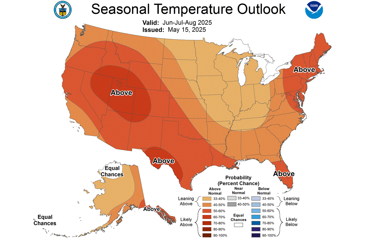
This is not far from the model forecast above, which showed the strongest warm anomalies over the western half of the United States and a disturbance towards the eastern United States. You can also notice a trough of weaker warm anomalies, indicative of a low-pressure system influence.
The official precipitation outlook is also close to the model forecast. We see an equal-to-higher probability for more rainfall over the eastern United States and parts of the southwest. But we see a below-normal precipitation forecast for the central and northwestern United States, under a high-pressure anomaly.
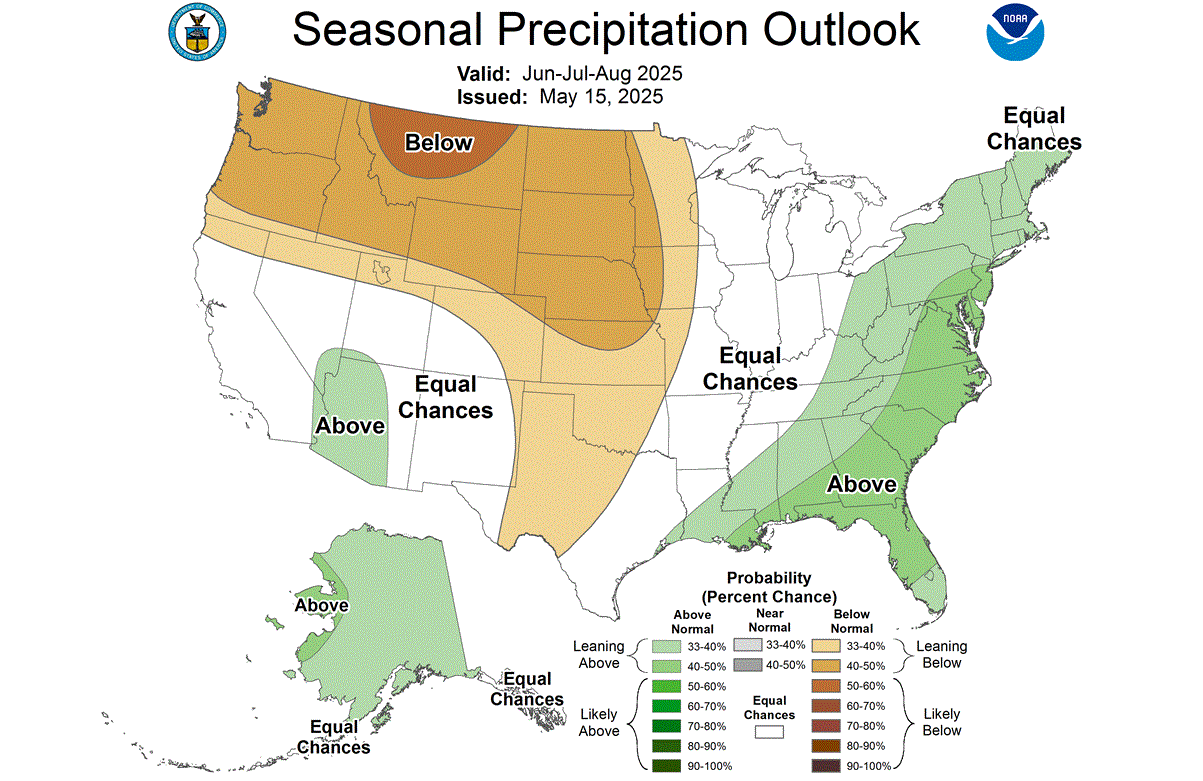
Both forecasts show features of the model outputs, indicating a general agreement in the latest trends for the Summer 2025 weather patterns over the United States and Canada.
Make sure to bookmark our page, so you don’t miss any latest weather forecasts and updates. Also, if you have seen this article in the Google App (Discover) feed, click the like button (♥) there to see more of our forecasts and our latest articles on weather and nature in general.
SEE ALSO:
Hurricane Season 2025 forecast: Above-normal activity expected with the warmer Oceans