Two intense Storms currently positioned south of Greenland will move rapidly towards Europe Wednesday, bringing a significant drop in geopotential before over the British Isles and then on the Alps and the Mediterranean. The formation of a secondary depression downwind of the main flow will trigger abundant precipitation over the Alps, with a lot of snow occasionally down to the bottom valley.
THE SYNOPTIC
Let’s have a look to the forecasted synoptic evolution over Europe and the North Atlantic for the next 7 days, from Wednesday, 12 to Tuesday, 18 April 2023. To do this, we mostly look at the European ECMWF model, which consistently proves to be the best in interpreting meteorological evolution on a European scale. The good news for areas like northern Italy and the Alps is represented by the arrival of the first intense Atlantic storm for at least three months. Let’s try to analyze why the situation seems, at least temporarily, to unblock itself after so many months of lack or even absence of significant rainfall there.
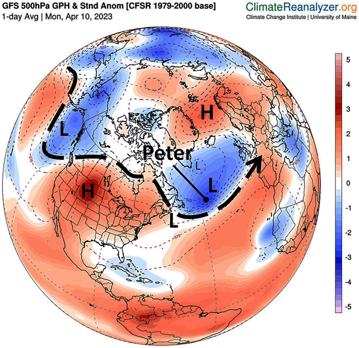
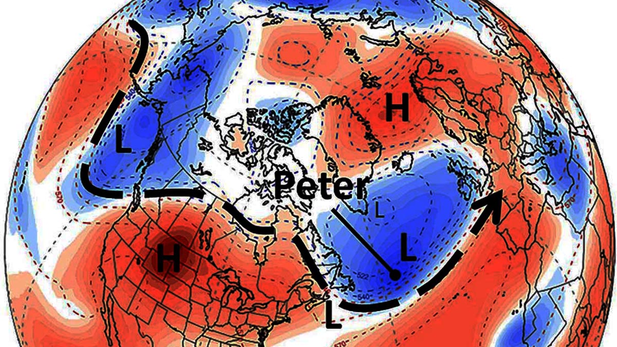
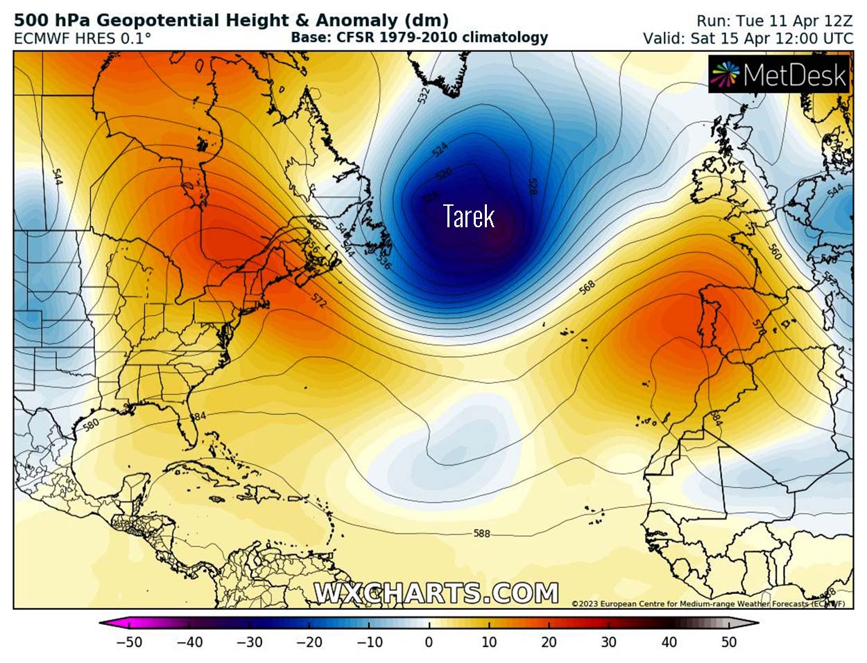
To do this, however, we have to move farther west. In the image above, the map of the geopotential anomalies at 500 hPa, corresponding to about 5500 m of altitude in the troposphere, modified by climatereanalyzer
The severe storm named Peter was composed of three different relative lows. Tuesday, the 11th, was positioned between Newfoundland and southern Greenland.
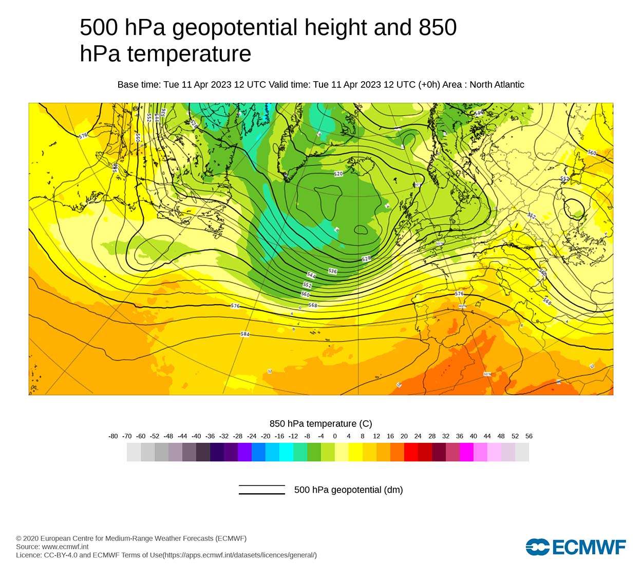
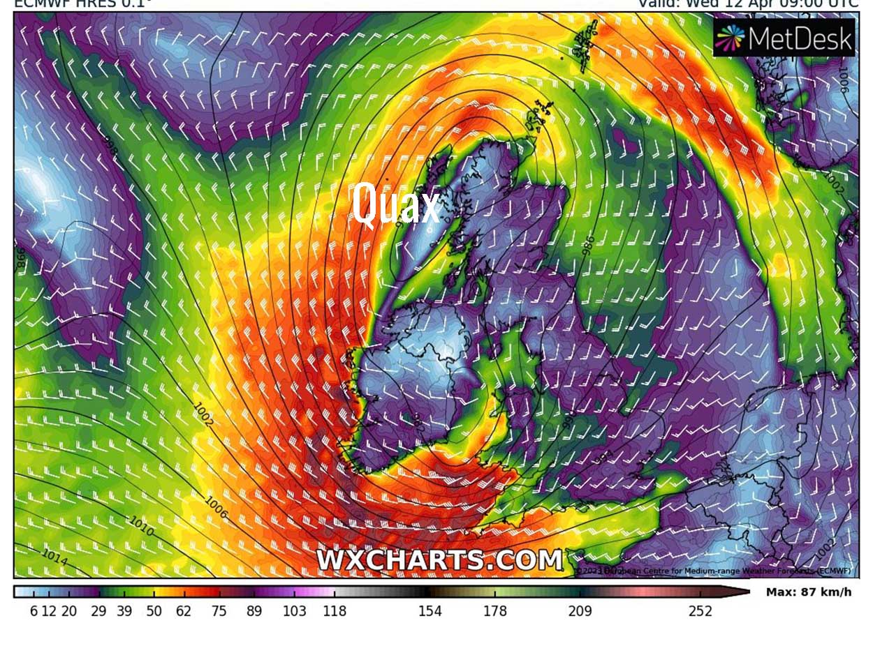
The storm just east of Newfoundland is fed by strong, freezing winds from the Arctic. At the geopotential height of 850 hPa, corresponding to roughly 1400 m asl, the temperature is as low as -12°C (see above). Thanks to the Arctic cold supply, this storm, already called Quax (see synoptic map below), will be the longest-lived and able to reach the British Isles on Wednesday morning, 12 April, with a phase of marked bad weather.
In this phase, southern Europe will still be affected by northwesterly winds aloft, associated with a temporary, slight increase in temperature after the colder-then-normal conditions of the Easter week. A weak front crossed the Alps on Tuesday but with no significant effects and without any precipitation. A second storm over North America, less intense than the previous one but directed much further south than the first, will, however, help the Quax depression to complete its task.
The new North American storm will lead to a rapid rise in the geopotential in the Atlantic, triggering a deep undulation of the zonal flow and helping the southward descent of the depression over the British Isles. In the following image, the new North American Low Tarek is positioned just east of Newfoundland on Thursday at 00 UTC.
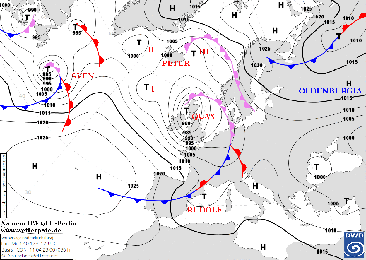
Since 1954 meteorologists at the Institute of Meteorology at Freie Universität Berlin in Germany have given names to high and low-pressure areas over Central Europe. Since 2002 the naming process has been open to anyone through the Adopt a Vortex program.
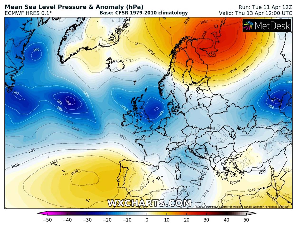
Participating individuals support the continuation of the weather observation in Berlin-Dahlem, up to now one of the longest weather series worldwide. What has been described above is clearly visible in the following image, centered precisely on Saturday, 15 April, in which we see the Azores High “squeezed” both from the west and from the east under the action of the two deep lows.
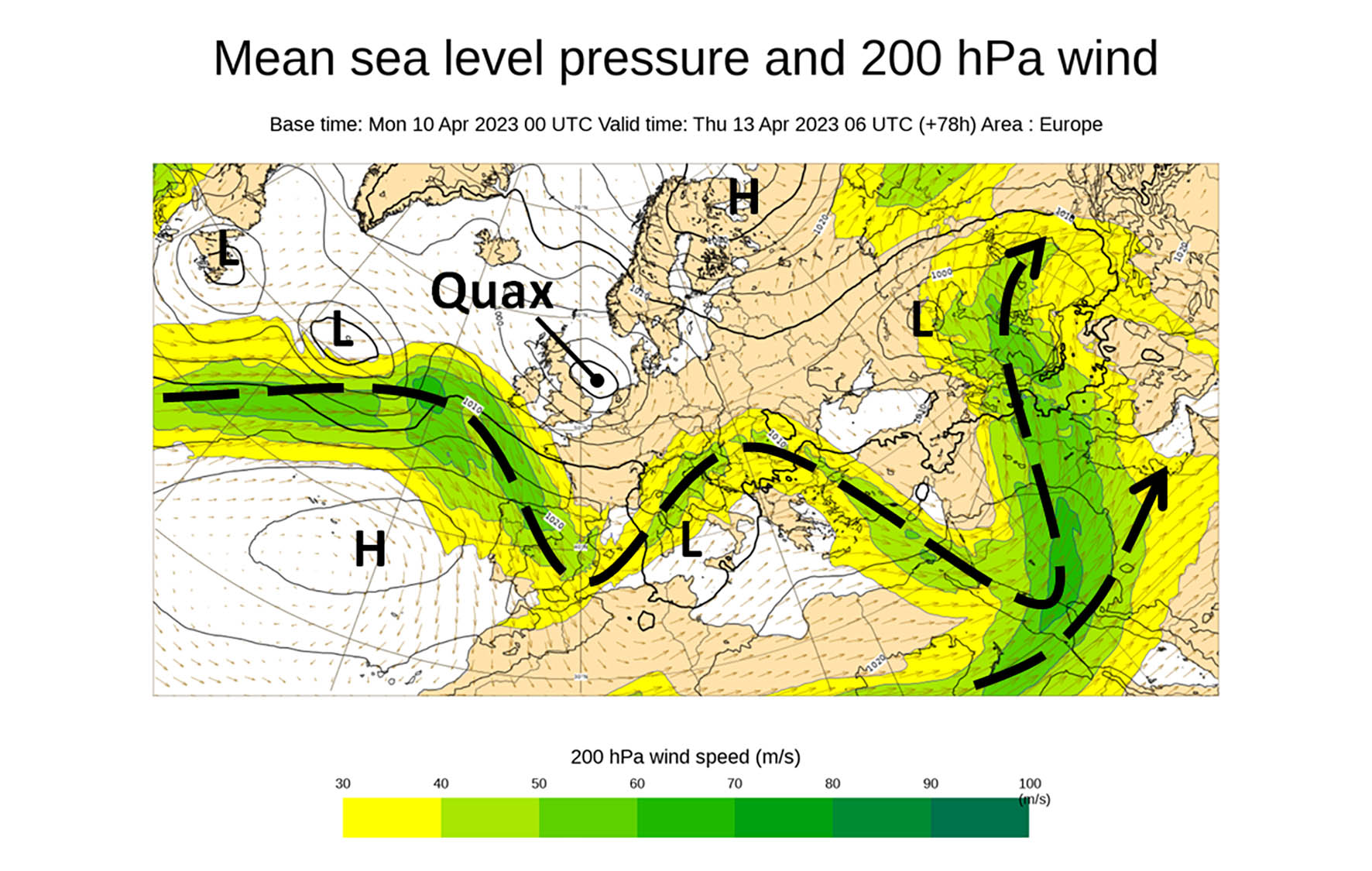
The storm Quax on the British Isles will move towards Scandinavia, but the ripple of the disturbed flow will enter the Mediterranean directly involving the Italian peninsula and the Alps. In the following image, which shows the pressure fields on the ground and the winds at 200 hPa, we see the jet stream’s behavior with the Alps and Northern Italy directly affected by southwesterly winds.
The center of the storm Quax at this stage is located between the British Isles and Denmark. For the first time in several months, it is possible to appreciate a chain of depressions from North America to southern Russia, within which the zonal flow is able to achieve its function without the interference of any blocking High.
This is clearly visible when looking at the sea level pressure map and associated anomalies forecast for 12 UTC on Thursday, 13 April. The Scandinavian High and the Azores High are no longer in communication and allow the zonal flux to enter Europe undisturbed.
This is a synoptic configuration that guarantees abundant rainfall for all of northern Italy and the Alps especially, particularly favored due to the effects of the orographic barrier (stau) on the northern and western sides of France, Switzerland, and Austria and on the southern Italian side.
It is important to note how the thermal context, thanks to the positioning of the low center of the storm on the ground downwind of the Alps, will cause the snow to initially fall at mid-mountain altitudes, approximately 1600-1900 m, and then rapidly drop below 1000 m. Occasionally, snow will fall to 500-800 m asl in the Eastern Alps, Slovenia, and the northern Dynaric Alps.

THE STORM QUAX OVER THE BRITISH ISLES
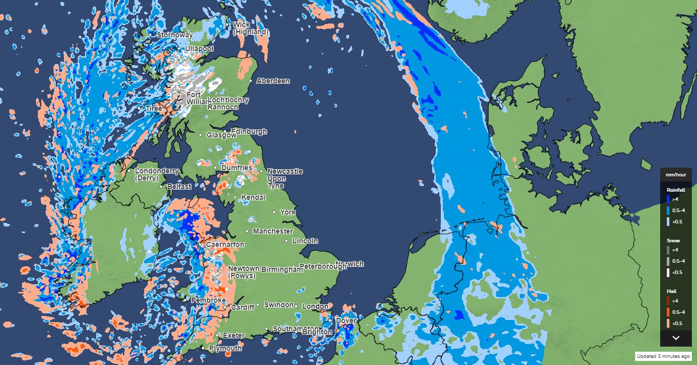
The Storm Quax is affecting the British Isles right now, with the center of the low located over Scotland with pressure values on the ground down to 973 hPa. In the image below, we can see the sea level pressure isobars, lines on a weather map that join places of equal pressure.
Meteorologists collect information from weather stations, buoys, and ships and then draw smooth curves to join the dots creating such pressure field maps.

As seen in the subsequent chart below credits met-office, precipitation is approaching Wales and the South West. Here small hail, snow pellets, and snow are reported. Mostly snow is reported from western Scotland, thanks to pretty low temperatures in the two main cores of the storm Quax.
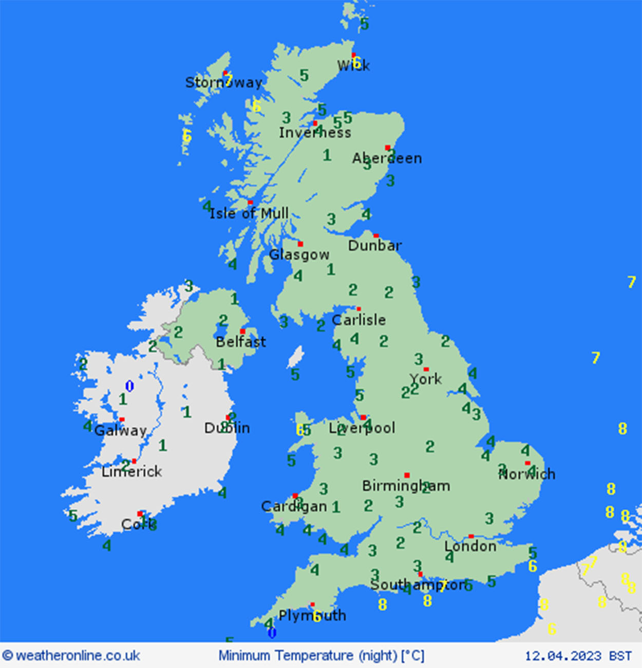
Values below -4°C are reported at 850 hPa in large parts of Scotland and Eastern Ireland, and virtually nowhere in the UK we find temperatures above -2°C at the 850 hPa Geopotential height. This is the detail of the two-meters minimum temperature this morning, thanks to Weatheronline.
Around the center of the storm, strong winds are blowing counterclockwise, especially on the western coast. As we can see in the map below with the wind fields over the entire UK, gusts reach 120 km/h west of Ireland and the UK’s South West coast.
Inland the wind blows less intense but with gusts between 50-80 km/h in Wales, West Midlands, and the South East.
The warm part of the storm is rapidly moving towards Denmark and Germany and will reach the Alps and the Mediterranean during the night. Especially in the Alps, precipitation is forecasted to be intense, and this will be a relief after such a long period of dry conditions.
According to leading international glaciologist Matthias Huss, the most recent measurements from Glamos (Glacier Monitoring Service in Swiss) show that snow water equivalent is very low in the northern Alps. The image below shows statistics from the small St. Annafirn, Central Switzerland. A new negative record for winter in the 12th year of the series is very likely to occur.

Indeed a major snowfall event brought some relief to Swiss glaciers last week. However, the gradient from West (up to 1m) to East (almost dry) was large. Data on glaciers indicate that the deficit persists and is worse than last winter season, 2021-22.

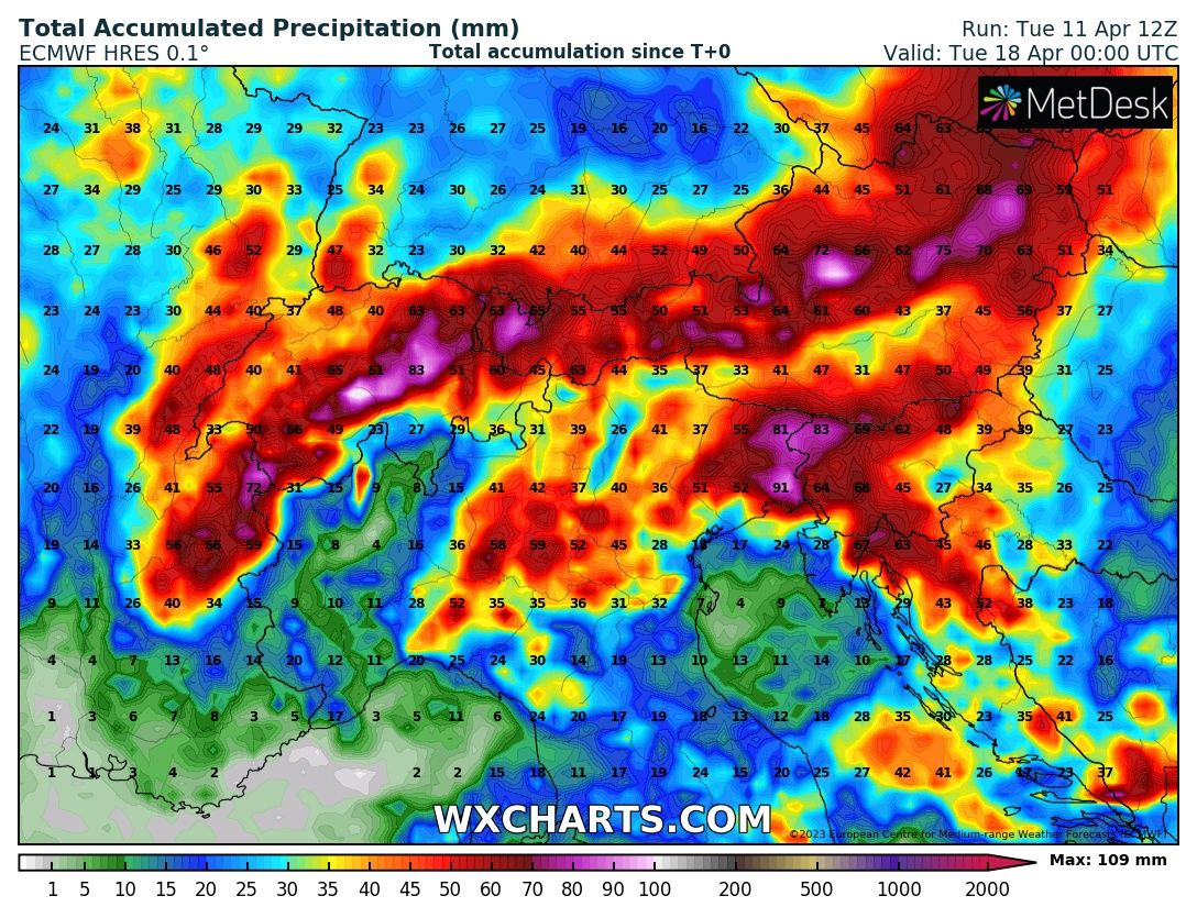
From France to Austria, the northern side of the Alps will likely record up to 80-100 millimeters in three days, and it will be mostly snow above 1000-1200 meters above sea level. On the southern side of the Alps, the precipitation hot spot is forecasted to occur in the Julian Alps sector, along the border between Italy and Slovenia, and the northern Dynaric Alps between Slovenia and Croatia.
The map below shows the forecasted total accumulated precipitation in millimeters per water equivalent from now to April 18th at 00 UTC. Only a small alpine sector in extreme northwestern Italy will have an orographic shade during this event.
THE POWERFUL HIGH OVER SCANDINAVIA NEXT WEEK
The renewed north push of the Azores High pushed by the deep low in the Atlantic will give a home to a profound wave in the jet stream able to isolate a powerful high-pressure system over Scandinavia. In detail below, we can see the forecasted mean sea level pressure and 200 hPa Wind for next Tuesday, April 18th, at 00 UTC.
The jet stream coming from the Arctic goes South to the Latitude of Spain in the Atlantic before abruptly turning north, reaching the Latitude of Tromso in northern Norway.
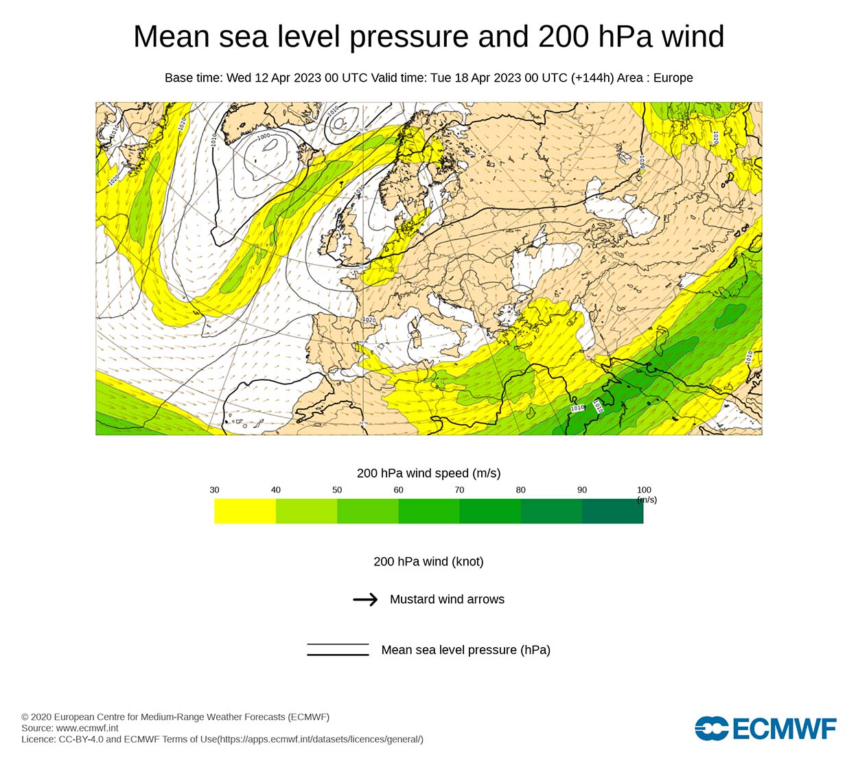
The absolute values on the ground will possibly reach 1040 hPa in Bergen, South Norway Wednesday, 19 April. This is roughly more than 30 hPa higher than climatological values for this period of the year.
This circumstance will certainly have important feedback on the weather in the upcoming weeks over Europe. This huge High-pressure system will block the zonal flow in Central and Northern Europe, eventually maintaining cooler and wetter conditions in southern Europe and the Mediterranean.

In the map above, the mean sea level pressure and anomaly in hectopascal forecasted by ECMWF thanks to the graphic wxcharts that we often used in this short analysis, together with a contribution from ecmwf weather charts.
We will keep you updated on this and much more, so make sure to bookmark our page. Also, if you have seen this article in the Google App (Discover) feed or social media, click the like button (♥) to see more of our forecasts and our latest articles on weather and nature in general.