Only a few days after violent twisters strike Midwest, another large Winter Storm Vanessa is forecast on Tuesday and Wednesday this week. Vanessa will form from a rapidly developing low along the Arctic cold front, forecast to blanket the Northern Plains with deep snow and intense blizzard while likely leading to a new tornado outbreak with strong tornadoes for the Mississippi Valley.
A swath of heavy, deep snow with blizzard conditions will develop from the Northern Rockies across South Dakota to Upper Midwest, extending into the northern Great Lakes and southern Ontario, Canada, through mid-week. Areas from Wyoming to Eastern South Dakota could see considerably big snowstorms and blizzards, making travel impossible due to huge snow drifts and blowing snow.
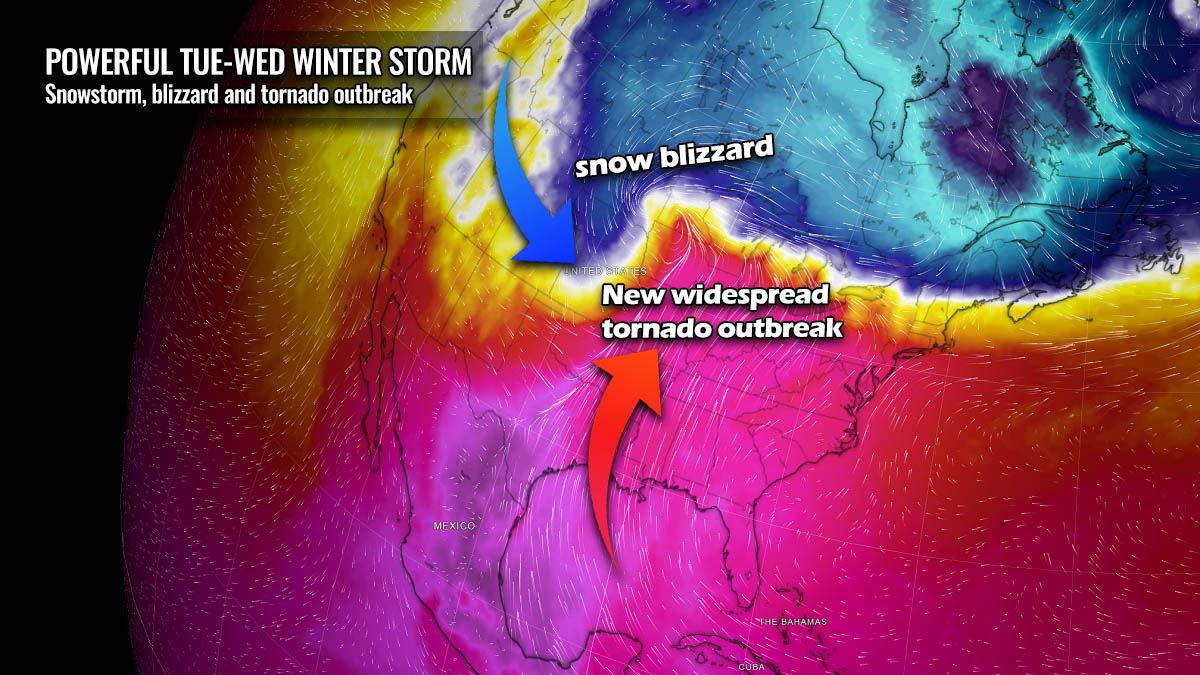
A concerning feature with a new Winter Storm Vanessa is a very sharp temperature gradient on both sides of the Arctic front. A significant warm air mass from the tropical region will be battling the Arctic cold near the rapidly developing surface low.
April is also the initial month of the tornado season in the Spring months; thus, tornado potential increases. Vanessa will bring back the widespread storm activity across the central United States. A combination of very warm and moist air near the surface and very powerful upper-level winds aloft suggest another tornado outbreak is increasingly likely on Tuesday into Wednesday.
It is important to note that severe weather threats will likely impact the same areas that were severely hit during last Friday’s tornado outbreak. Additionally, Chicago, St. Louis, and Little Rock are also in the path of the storms.
Portions of the northern U.S., from the Rockies to the Upper Midwest, are already under the effect of winter storm watches and warnings ahead of the incoming Winter Storm Vanessa. Areas are expected to be upgraded as the storm unfolds late Monday into Tuesday. Blizzard conditions will develop.
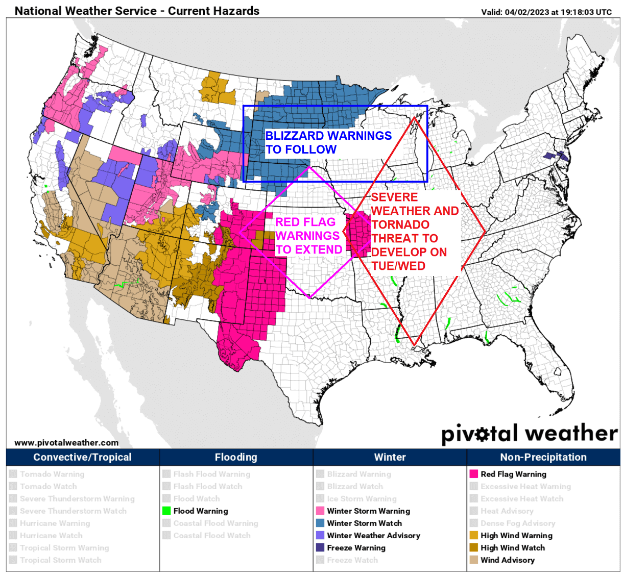
Farther south across the Southern High Plains, Red Flag Warnings are in effect due to extremely dry air mass. With surface low rapidly deepening on Tuesday, the fire threat will also expand into the central Plains and Midwest. Rapid moisture return across the central U.S. will develop severe weather and tornado threat on Tuesday.
This new significant weather impact forecast through mid-week is due to the amplified pattern across North America. The remnants of the collapsed Polar Vortex aloft in the late Winter Season have changed the pattern across the continent, sending a powerful Arctic Blast from Canada into western portions of the Contiguous U.S.
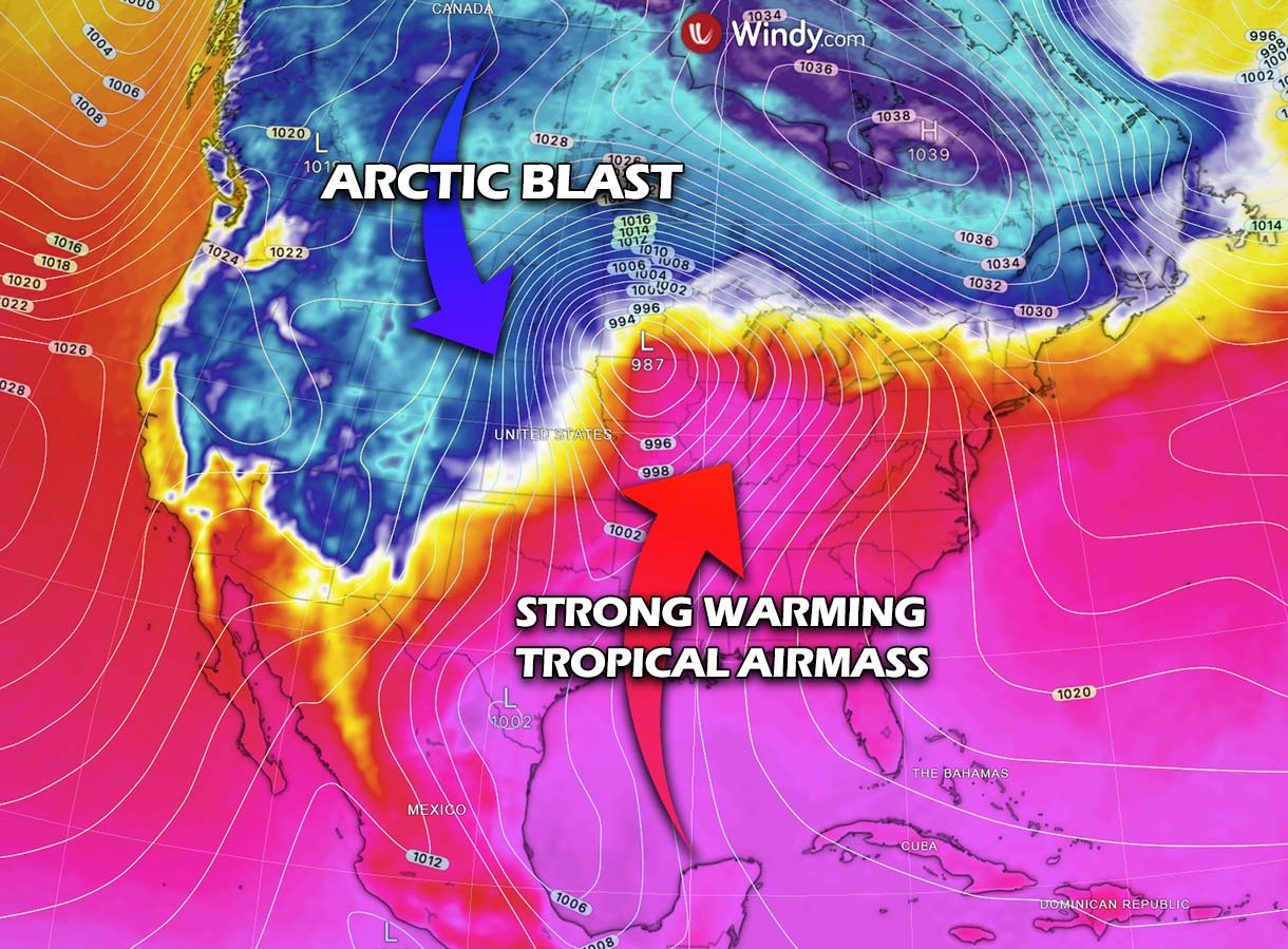
While Arctic cold spreads in the wake of the frontal system, a significant warmth returns across the Central and Southeast U.S., reaching far north across Midwest to the Great Lakes region. This happens in response to the deep surface low forming along the sharp Arctic front.
This will also develop a huge temperature gradient across the continent, meaning temperature and pressure differences are large. Thus, potentially introducing stronger winter storms, heavier snow, and blizzards across the north, while a potentially new tornado outbreak will develop across the Mississippi Valley. Affecting areas from Arkansas, Missouri, Iowa, and Illinois again this Tuesday and Wednesday.
Significant travel impacts are expected across the region from winter weather and severe thunderstorms. Some locations from Wyoming to South Dakota can expect to see at least a foot of snow by the time Winter storm Vanessa vanishes late Wednesday. The worst conditions are expected on Tuesday and Wednesday.
Heavy snow in the north will combine with north-northeast winds, gusting up to 60 mph. The extreme blizzard forecast will lead to significant drifting snow and whiteout conditions in open areas. Expect roadblocks and impossible travels.
The above video animation reveals how a much colder Arctic air is forecast to plunge behind the winter storm Vanessa from Canada, gradually expanding into the north and northwestern U.S. and the northern Rockies through mid-week. Freezing weather will continue into Dakotas and Upper Midwest through Wednesday and Thursday.
It will remain warm to the south and east, with temperatures in the upper-70s to mid-90s across the Deep South and Southeast U.S.
Let’s now take a more detailed view of the potential impacts of this new significant weather system emerging over the next 72 hours.
WINTER STORM VANESSA DEVELOPS ON LATE MONDAY AND RAPIDLY STRENGTHENS OFF THE ROCKIES TOWARD DAKOTAS ON TUESDAY
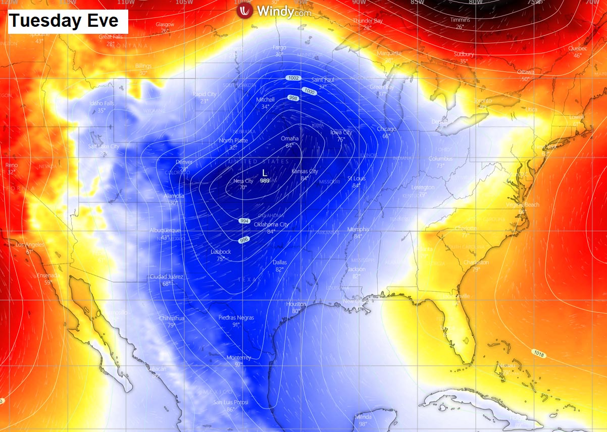
The new frontal wave emerges into the northern Rockies with a rapidly developing winter storm on Monday night. The surface low then considerably intensifies while moving across the High Plains before turning east towards the Midwest.
This week’s general weather pattern across the Contiguous U.S. reveals a classic dipole setup, with a large upper-level wave emerging from the west and an upper High across the East Coast. With a developing violent frontal system across the northern-central Plains on Tuesday.
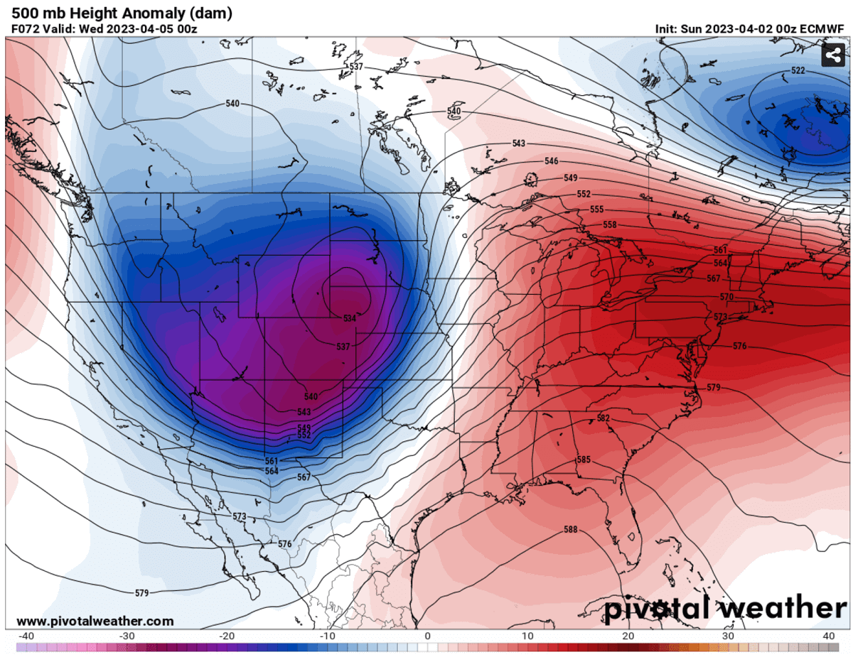
Between these large-scale features, a powerful upper-level jet stream spread across the Rockies, allowing the surface low to deepen into a major winter storm as it tracks across the northern states on Tuesday. Therefore, developing a high potential for a wide swath of deep snow for tens of millions across several states in the north.
Strong pressure and temperature gradient to the south of the low induces severe winds across the southern Rockies and central Plains, nosing towards Midwest with extremely dry air mass. Posing a threat for wildfires and blowing dust storms.
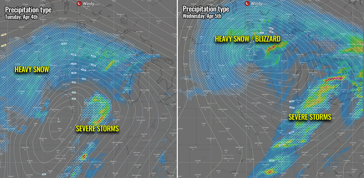
At the same time, deep moisture is dragged from the Gulf of Mexico northward, resulting in widespread heavy precipitation for the Midwest. High humidity also transports into the cold side of the Arctic front, fueling the heavy snow across parts of the northern Plains.
The new winter storm Vanessa will be tracked east and impact the northern states with heavy snow and blizzards, from Montana and Wyoming across Dakotas to northern Minnesota and northern Wisconsin. To the east of the moving low, heavy rain will develop with some potential for freezing rain near the northward surging warm front.

The above charts for Tuesday also show widespread heavy rain and thunderstorm activity across the central portions of the U.S. That’s where the tornado outbreak potential will be the most significant. See the section further below for details on the severe thunderstorms.
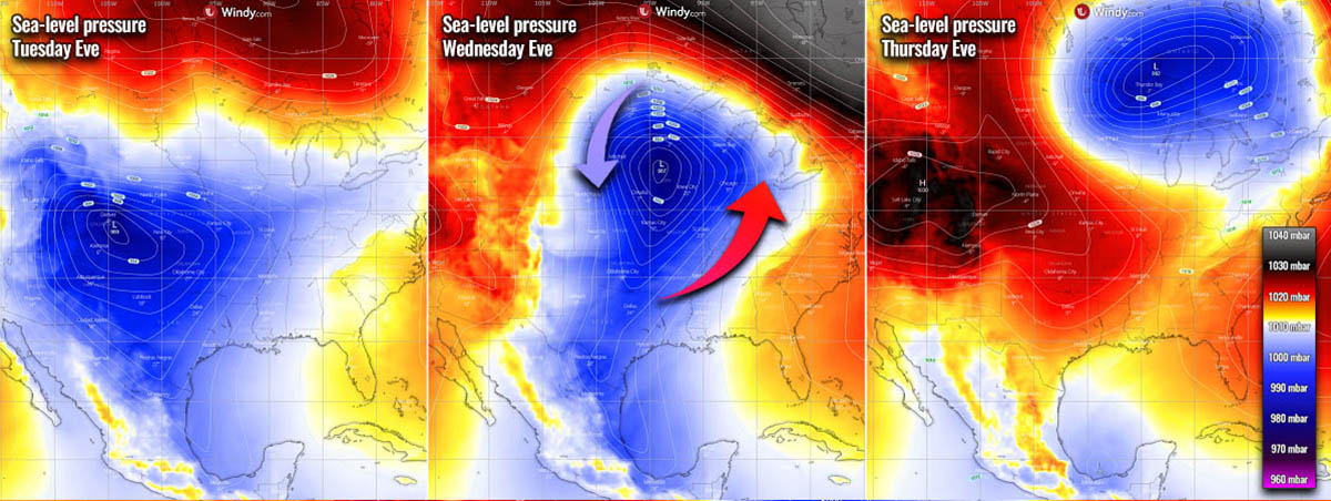
Attached is the composite chart of the evolution of winter storm Vanessa from Tuesday thru Thursday. We can see a rapidly deepening pressure on Tuesday off the northern Rockies into the Midwest, ejecting into Canada on Thursday.
A frontal system of such scale often brings a widespread severe weather impact from wintry and stormy weather nationwide. Stay alert for your local weather office updates.
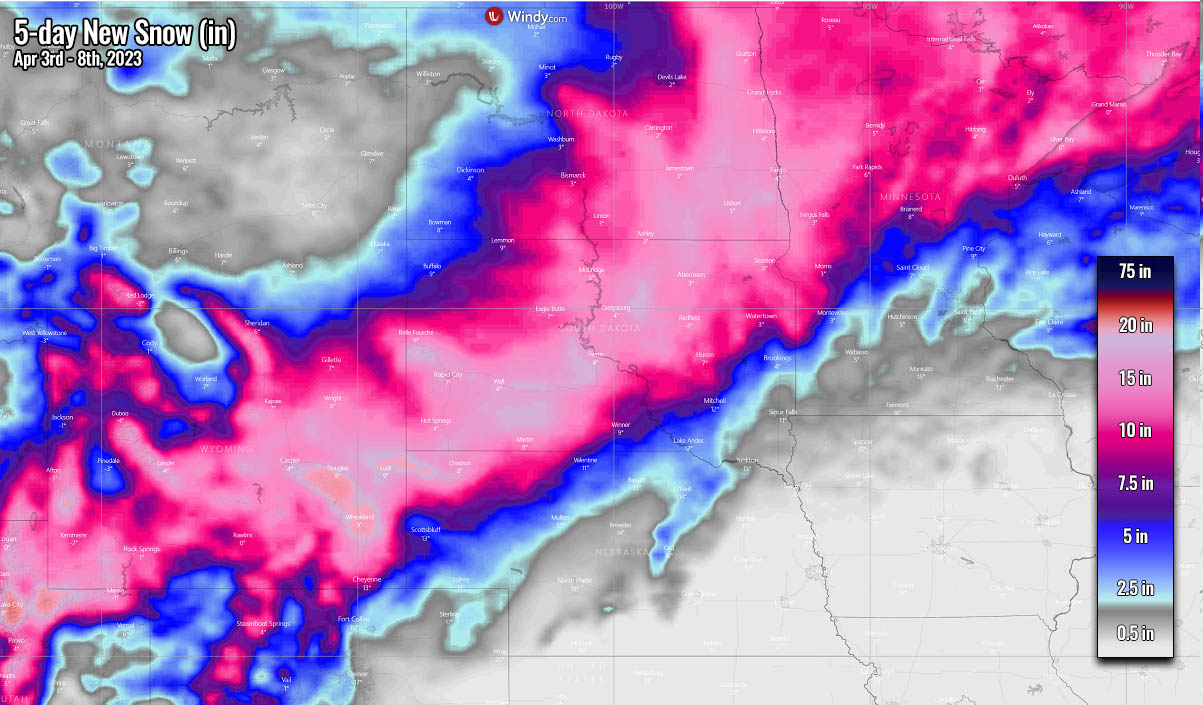
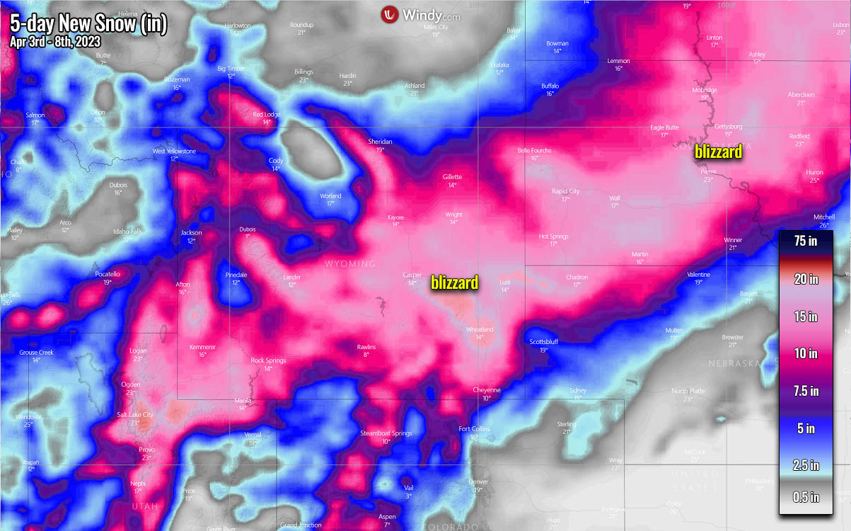
LIKELY 1-3 FEET OF SNOW AND BLIZZARDS ALONG THE NORTHERN SIDE OF WINTER STORM VANESSA
Associated with the deep upper trough digging into the West, heavy snow with strong to severe winds will develop over the Northern Rockies late Monday, forecast to spread across the Northern Plains on Tuesday and Wednesday. The surface low-pressure system will rapidly deepen and move towards South Dakota on Tuesday evening, spreading heavy snow with blizzard conditions.
The amounts of snow will be the most abundant and heavy along and to the north of the core of storm Vanessa. A heavy, deep snow swath will extend from central Wyoming to South Dakota, eastern North Dakota, and northern Minnesota. As well as into southern Manitoba and southern Ontario, Canada, on Wednesday.
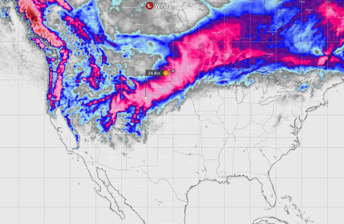
Snow totals could be between 1-3 feet, with locally higher amounts expected in the Western mountains, e.g., east-central Wyoming (3-5 feet possible). This will bring large cities into the impact of heavy snow and blizzards, including Cheyenne, Rapid City, Aberdeen, Bismarck, Fargo, Grand Forks, and International Falls.
The exact swath of the most intense and excessive snowfall depends on the position of the center low, but weather models were handing Vanessa pretty well this weekend.
Winds will be gusting 40-60 mph and are forecast to introduce intense blizzard conditions over portions of the North and Midwest from Late Monday through Tuesday night. Also, expect power outages and tree damage in some areas; whiteout conditions and major snow drifts will create impossible travel and cause delays.
Many roads and highways, including portions of Interstate I-90, will likely be shut down for a day or two.
A decent amount of snow is also forecast for Salt Lake City, UT region, about 1-2 feet likely in the mountains.
While the most widespread, heavy, and drifting snow will be from central Wyoming to a large part of South Dakota into eastern North Dakota, these areas are forecast to be blasted by severe blizzard conditions for around 48 hours.
Travel delays, including airline delays, are therefore expected.
MORE ARCTIC COLD AIR MASS FOLLOWS IN THE WAKE OF VANESSA FROM CANADA INTO NORTHERN STATES
After Tuesday, a large Arctic cold pool in the wake of the frontal system will be dragged from Canada into the northern parts of the U.S. Temperatures are forecast to be around 20-40 °F lower than normal from Montana to North Dakota in early April.
The 850 mbar temperature anomaly composite is attached below, indicating that the significant cold first stays over the northwestern portions of the U.S., gradually spreading east through Wednesday until Thursday. While to the south and east, a significant warmth is further increasing while spreading onto the Great Lakes region.
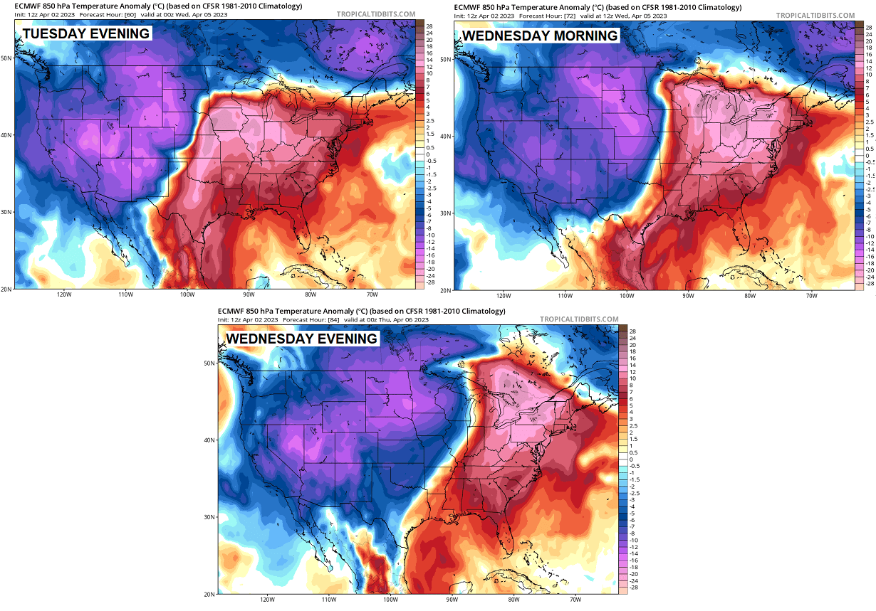
As we see, a sharp temperature difference develops between both cold and warm reservoirs. This is where the Arctic front is placed, and surface low forms. Cold will wrap around the core of the low, as we see on the upper right chart.
Looking closer at this sharp temperature contrast across the Northern Plains and Midwest, we see a nearly 60 degrees C difference on Tuesday evening. While western Nebraska and South Dakota will have temperatures 15-20 °C below normal, those will be around 25°C above normal in eastern Nebraska and western Iowa.
The cold air mass behind storm Vanessa will intensify Tuesday night into Wednesday. Temperatures are forecast to plunge 20-40 °F below normal across Wyoming, Montana, and Dakotas. Single digits are forecast from eastern Montana to Dakotas on Wednesday and Thursday morning. With temperatures below freezing as far south as northern Oklahoma and Ohio Valley on Thursday morning.
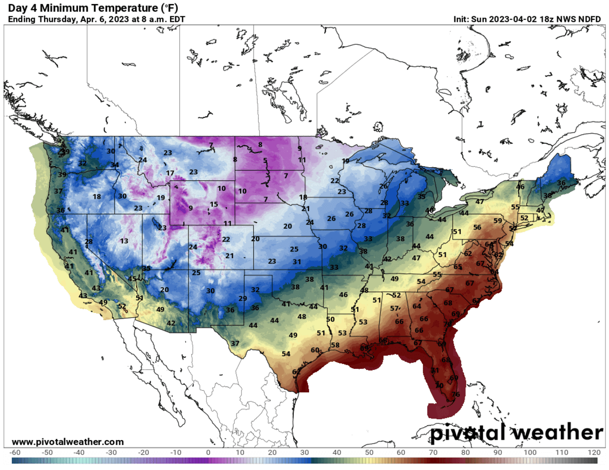
Temperatures will remain below freezing for most of Tuesday, Wednesday, Thursday, and Friday across the North, with low 20s °F across Montana, Wyoming, North Dakota, western Nebraska, and most of South Dakota and northern Minnesota.
Meanwhile, Tuesday will bring extreme warmth with high temperatures for the southern, central, Southeast, and East Coast. Peak temperatures will be in the low to mid-90s in central Texas, closing to 100 °F near the Mexico border. Low 90s also in central Florida. Creating an impressive temperature contrast nationwide.

These high temperatures also allow the air mass to hold much more moisture that will gradually recover towards the north ahead of the frontal system. Thus developing more unstable weather conditions and increasing the potential for severe thunderstorms.
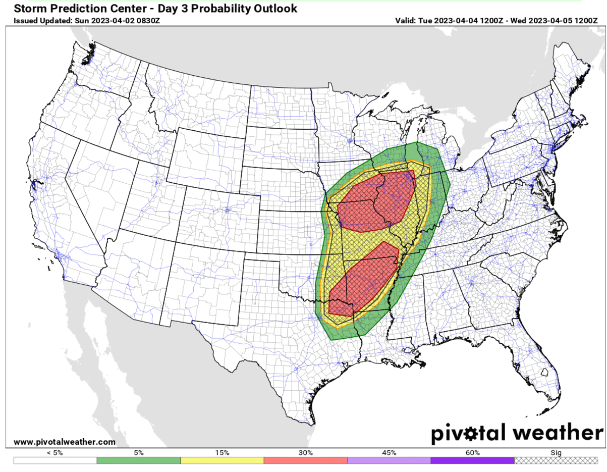
ANOTHER TORNADO OUTBREAK IS INCREASINGLY LIKELY ACROSS THE MISSISIPPI VALLEY, WITH STRONG TORNADOES POSSIBLE
Thanks to a very powerful warm advection of tropical air mass into the central parts of the country, more severe thunderstorms appear likely to develop late Tuesday afternoon into Tuesday night. Precisely across the lower Missouri Valley into southern portions of the Upper Midwest and across parts of the southeastern Great Plains into portions of the Mid South.
The potential is there for another risk of a few strong tornadoes, large hail, and severe wind gusts. A lot of moisture will return to the Mississippi and Ohio valleys again due to a strong low-pressure system emerging from the Rockies toward the Upper Midwest.
Based on the latest weather model forecast, a plume of high-level moistening and large-scale ascent overspread much of the warm sector ahead of the Arctic front across the Ozark Plateau into the middle Mississippi Valley. To the southeast of the deepening surface cyclone, near the intersection of the warm front and dryline, these areas offer the best potential for initiating intense, sustained thunderstorms. This will be near the Missouri River, across parts of northeast Kansas, southeastern Nebraska, southwestern Iowa, and northwestern Missouri.
Rather a widespread storm activity will include discrete supercells initially before convection gradually grows upscale into an organizing, eastward propagating cluster of storms (MCS) along and south of the warm front. This is supported by a particularly intense jet stream (upper-level winds) aloft, as we can see in the following image.

Farther south across the lower Mississippi Valley, the developments remain more unclear. Ahead of the cold front as it overtakes the dryline and surges southeastward into the Ozark Plateau, a corridor of enhanced severe weather potential develops by Tuesday evening. One or two long-track supercells could form ahead of a developing squall line.
Therefore, a widespread tornado outbreak is again possible across both potential regions with a higher impact.
Windy, Pivotalweather, and Wxcharts provided images used in this article.
See also: