We have entered the Fall meteorological season, and the weather patterns are starting to change. A blocking system looks to dominate the rest of the month over North America, with a warmer westerly flow over Europe. The rest of Fall does, for now, look to be under the growing influence of the El Niño.
El Niño is an ocean anomaly in the tropical Pacific. It affects the weather patterns on a global scale seasonally by impacting the delicate ocean-atmosphere climate system.
We will first briefly look at the past Summer, look more closely at the growing El Niño, and then analyze the latest weather forecast for the rest of the Fall season across the United States, Canada, and Europe.
AS THE SEASONS CHANGE
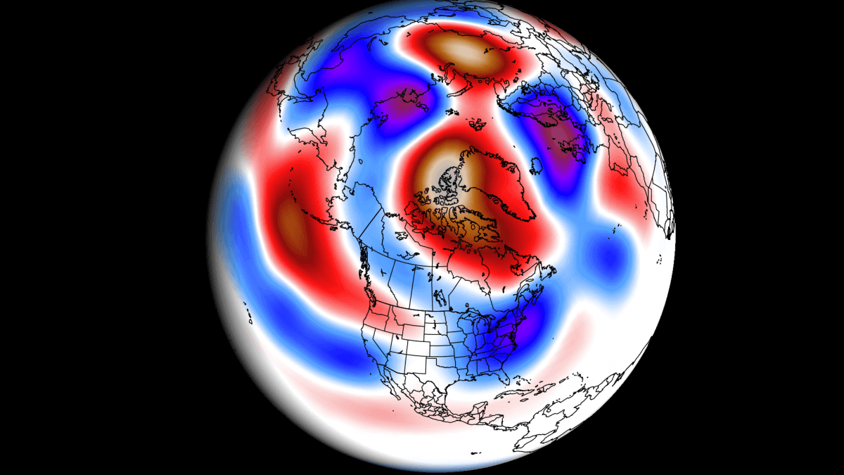
Before going into the forecast, let us quickly examine how the past summer season panned out. Below, we have a pressure anomaly analysis for the June-August period. This covers the meteorological Summer.
A large part of the summer season was a high-pressure system over the far North Atlantic and another one over western Canada. This prompted a low-pressure zone to develop over the eastern United States, across the Atlantic, and into northwest Europe.

But keep in mind that this is a 3-month average. So, while it shows the prevailing weather patterns, it can hide quite a bit of variability.
Looking at temperatures for the same period, you can see mostly above-average temperatures across the mid-latitudes. The exception is the eastern United States, which mostly featured normal summer temperatures. The Appalachians and lower Great Lakes even recorded slightly below-normal temperatures.

Parts of California also recorded below-average temperatures. The strongest warm anomalies were found across northern Canada, the Pacific Northwest, and the southern United States. Europe also featured warmer-than-normal temperatures across much of the continent.
Looking over the June-August precipitation, you can see more rainfall in the central and northeastern United States. Above-average rainfall is also seen across much of Europe, with several flooding events over the season.
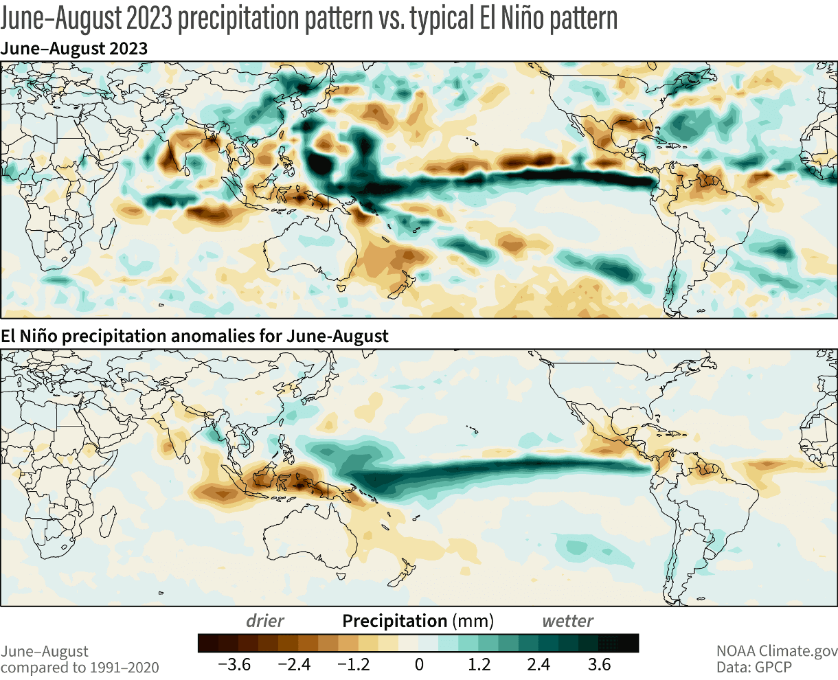
The image also shows the summer precipitation anomaly versus a typical El Niño precipitation pattern. You can see that the rainfall pattern across the equatorial regions is almost exactly as you would expect from a typical El Niño season.
This indicates a growing presence of the El Niño in the atmosphere. This has implications for the rest of the Fall season and especially for the Winter of 2023/2024.
You have probably heard the term El Niño in 2023 or read about it in the news. But for those who are not so familiar with it, we will quickly run down what El Niño is and what it does.
EL NINO 2023
El Niño is a phase of the ENSO, which stands for “El Niño Southern Oscillation.” This is a region of the equatorial Pacific Ocean that experiences regular shifts between warm and cold phases. Typically, there is a phase change around every 1-3 years.
Each ENSO phase influences the pressure and weather in the tropics differently. This affects the overall global circulation over time, changing the weather patterns worldwide. The cold ENSO phase is called La Niña, and the warm phase is called El Niño.
The following image below from NOAA Climate shows the typical circulation during an El Niño event, which will be the dominant phase for Fall and Winter 2023/2024.
Rising air in the eastern Pacific causes more storms and precipitation and lowers the pressure over that region. At the same time, the air is descending in the western Pacific, causing stable weather and high-pressure conditions. Image by NOAA-Climate.
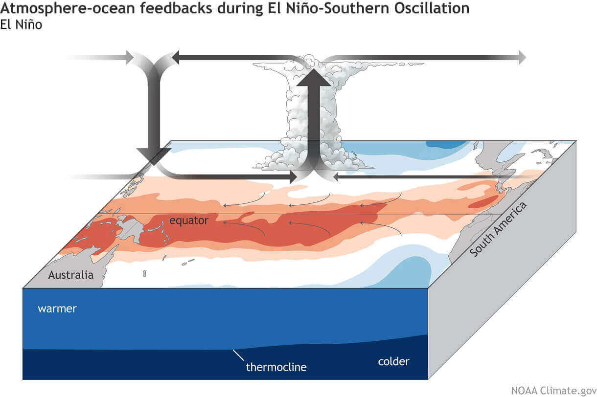
This way, ENSO strongly impacts the tropical rainfall and pressure patterns, affecting the ocean-atmosphere feedback system. Through this ocean-atmosphere system, the ENSO influences the weather globally.
These pressure changes translate into global circulation over time, affecting seasonal weather over both Hemispheres with some delay.
Below is the latest ocean temperature anomaly analysis. It shows where the ocean surface is colder/warmer than normal. You can see a strong, warm anomaly (marked) in the tropical Pacific. That warm ocean anomaly is the El Niño event.

These anomalies mean that the pressure and precipitation patterns are changing across the tropical regions. But as the whole atmosphere is one big system, these changes slowly impact the rest of the world.
So, while the El Niño has its own impact, you can also see it as a sign of changes on a global scale. El Niño needs a specific global setup to form. So you can imagine the El Niño just as a “control light” on the dashboard of a car.
You can see the evolution of the ENSO regions in the video animation below. It shows the ocean temperature anomalies from Winter to Spring 2023.
The cold La Niña anomalies quickly broke down over the Winter, with warm anomalies emerging in early Spring. Notice the motion of the anomalies, being driven by the trade winds.
This is how the El Niño was born, as the pressure and circulation changes on a larger scale enabled its existence. And this gives us a signal of what is to come.
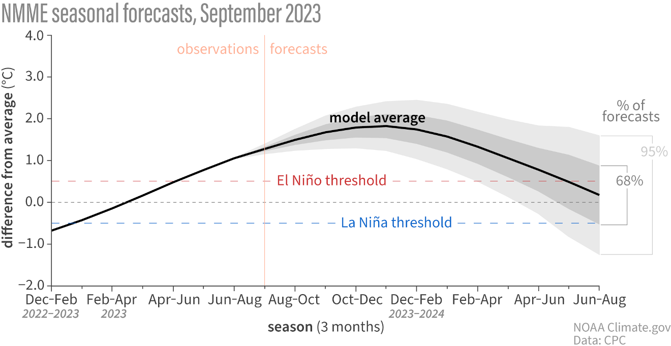
In the image below, you can see the evolution and forecast of this El Niño event. The model forecast indicates a moderate to strong El Niño event will dominate the entire Winter. But its effects will likely be felt at least into Spring 2024.
This pretty much confirms that we will have an active El Niño event over the Fall season. So, what did the El Niño seasonal influence look like in the past?
PAST EL NINO FALL WEATHER PATTERNS
There have been many Fall/Winter seasons with an active El Niño phase. Looking back to 1980, there have been 11 such seasons so far.
We produced special graphics showing the combined/average El Niño Fall season in the past. Simplified, it shows the prevailing Fall signal during an active El Niño phase.
First, we have the pressure pattern, covering the Autumn season. You can see low-pressure zones over Canada and the western United States and a large low-pressure zone over the North Atlantic. This is a positive NAO signal.
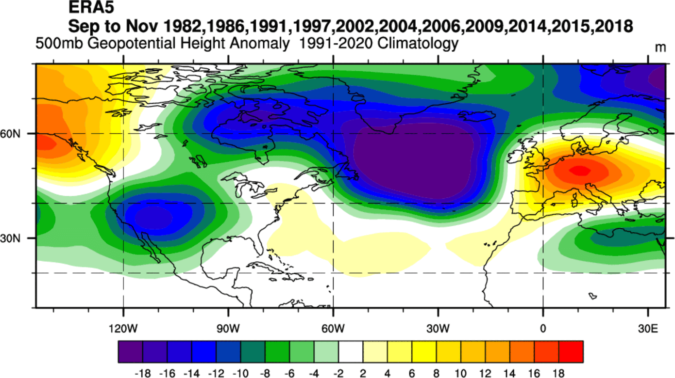
You can also see a high-pressure system over Alaska and Europe. The European high is a response to the positive NAO signal and the strong low-pressure zone in the North Atlantic. Similar goes for the ridging over Alaska and a low-pressure response over the United States.
Next, we have the temperature patterns. You can see a broad negative anomaly over Canada due to the strong positive NAO signal. You can also see a cold signal over the United States and mostly warm weather over Europe under the high-pressure zone.
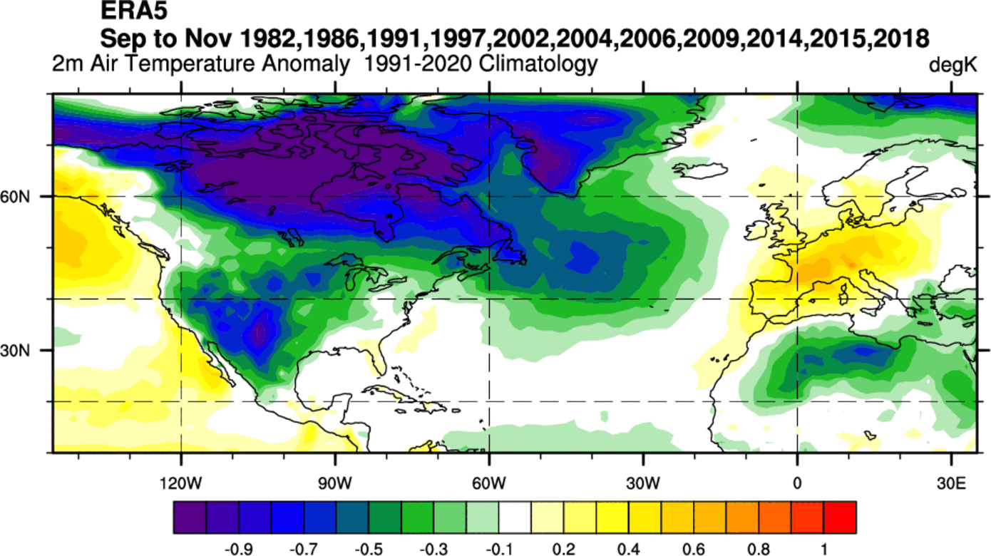
But here, we must add that some of the years in this composite image are from the 80s and early 90s, which generally had lower temperatures overall. That also meant the cold source regions up to the north were colder and could create stronger Fall season cold outbreaks.
Precipitation patterns in an El Niño Fall season show a strong wet signal over the southern and southeastern United States. Europe is seen mostly drier than normal due to the high-pressure system, apart from the far western and northwestern Europe and Scandinavia, courtesy of the strong low-pressure system in the North Atlantic.

Looking at the past El Niño influences, we can see three main takeaways for the next few weeks:
- A low-pressure zone across the United States and the North Atlantic
- Warm temperature anomalies across Europe and normal to below-normal temperatures across the United States.
- More precipitation across the southern and eastern United States
Keeping this in mind, we will look at the forecast for upcoming weeks and the monthly weather forecast trends.
SEPTEMBER WEATHER FORECAST
We will first look at the month so far, as September is already underway. The pressure anomaly for the first two weeks shows a strong omega-blocking pattern over Europe. A high-pressure system sits over the North Atlantic and southeastern Canada.

A similar but much weaker blocking pattern is found in the United States. Low-pressure zones are found over the eastern and western United States, and a ridge rises over the central United States.
Below is a global temperature analysis for the same period from climatlas. You can see the warm anomalies across the southern and central United States, most of Canada, and much of Europe.
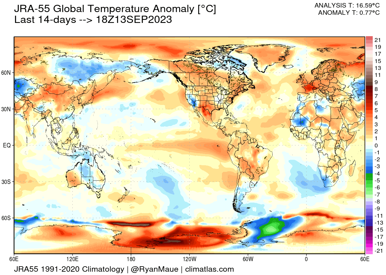
Normal to below-normal conditions were recorded across California and parts of the eastern United States. Notice the warm anomalies over the eastern tropical Pacific Ocean in response to the active El Niño event.
WEEKLY WEATHER FORECAST
Going into the forecast, we have the pressure pattern forecast for next week below. What stands out is the blocking pattern over Canada. This is a split-flow pattern over the eastern United States, known as a Rex blocking pattern.

Another low-pressure anomaly is over northwestern Europe and the North Atlantic.
Looking at the temperature anomaly over Europe for the same period, it is much warmer than normal across most of the continent. A cooler, northerly flow is expected over the far western parts. This warmth is due to a strong southerly flow over the continent.
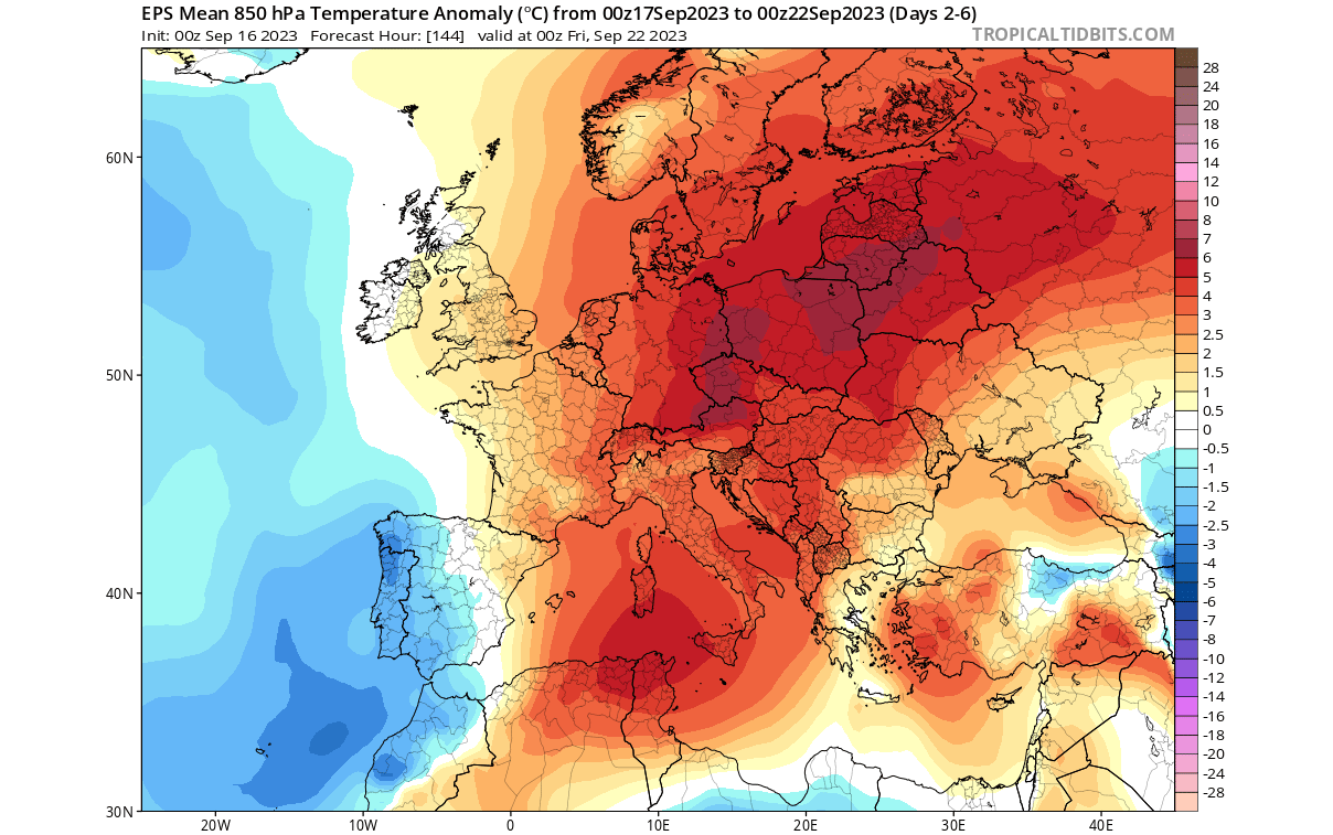
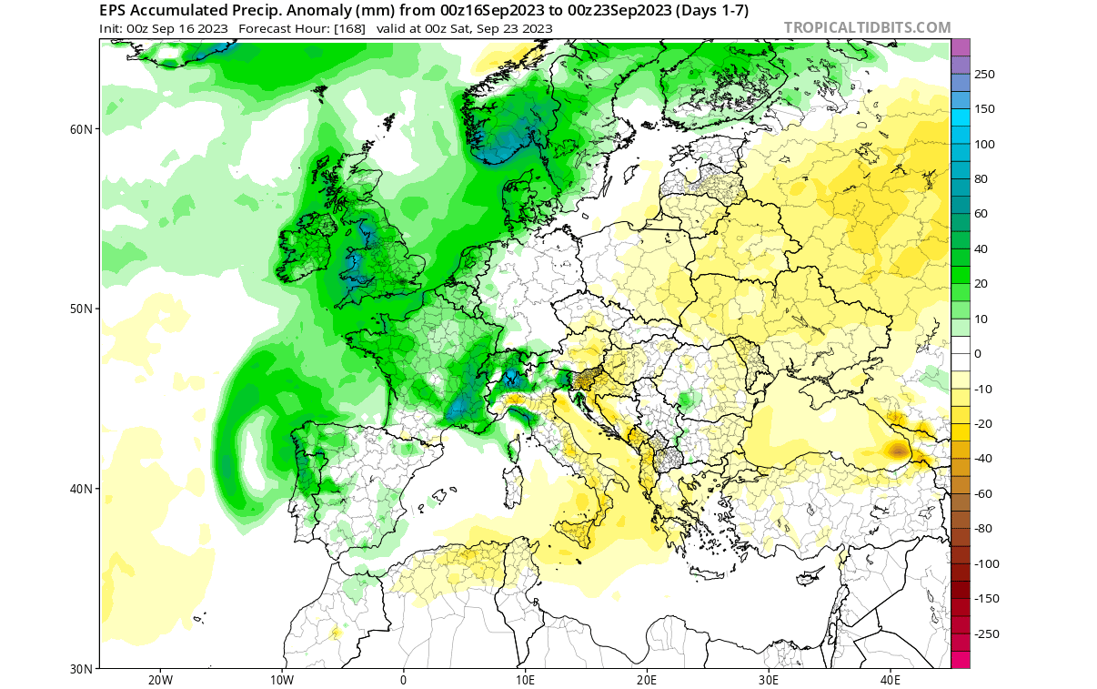
The precipitation forecast shows the influence of the low-pressure system over northwestern Europe. There is more precipitation in that region and across the western parts. Central and eastern regions are forecast to be drier.
The temperature forecast across the United States is different. A cooler anomaly sits over the eastern United States under the weakening low-pressure zone. Southern Canada and the central and western United States will be under a warmer airmass.

California can be seen with cooler anomalies extending into the state from the Pacific. This is one of the signs that El Niño is slowly expanding its influence.
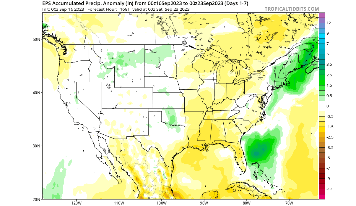
Looking at precipitation, there are mostly drier conditions forecast for the next seven days across the eastern half of the United States and Canada. More precipitation is forecast across New England and the Canadian Appalachian region from the remnants of Hurricane Lee.
WEEK 2 WEATHER FORECAST
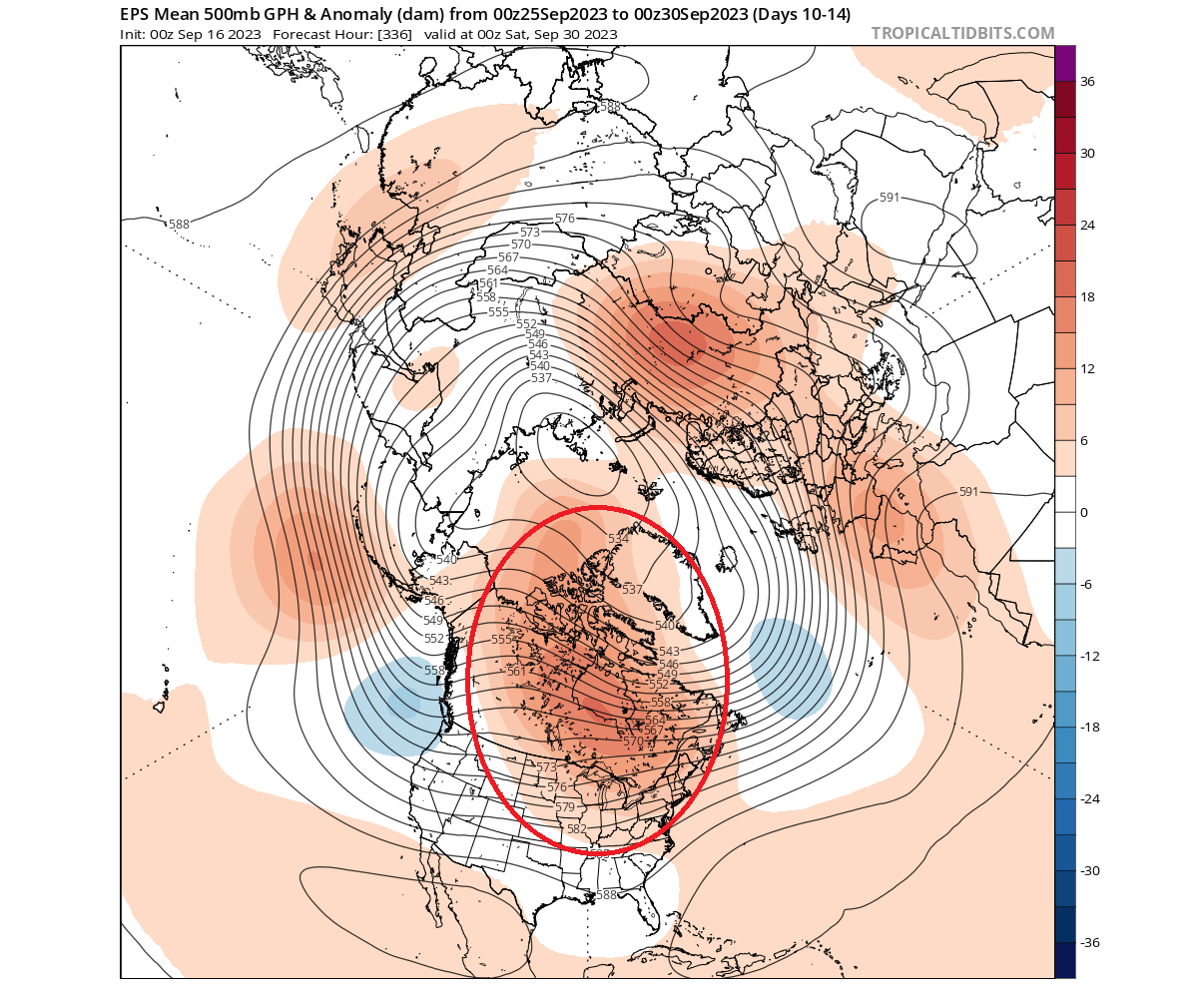
Going into the late month, the pressure pattern will progress. The blocking high-pressure system will remain over Canada and expand its influence into the United States. Meanwhile, Europe will be under a high-pressure zone, with a transitioning weak low-pressure area.
Looking at Europe first, you can see most regions being warmer than normal. A weaker warm anomaly is seen across central Europe as a low-pressure trough transitions over.

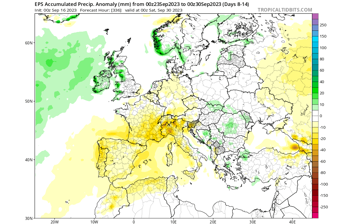
Precipitation-wise, northern and partially central parts will see more precipitation in the last week of September. Drier conditions are forecast for the west-central parts.
The final week of September will bring warmer temperatures back to the eastern United States as the high-pressure expands down. Canada and the southern United States will also remain warmer than normal. But cooler anomalies will expand further up the West Coast.

More precipitation is forecast across the middle east coast. A larger area of increased rainfall is also forecast across the great plains, parts of the upper Midwest, and the Pacific Northwest.

OFFICIAL NOAA FORECAST
We can see a similar late-month forecast in the NOAA weather outlook. Much warmer weather returns to the eastern United States, while cooler conditions prevail in the west.
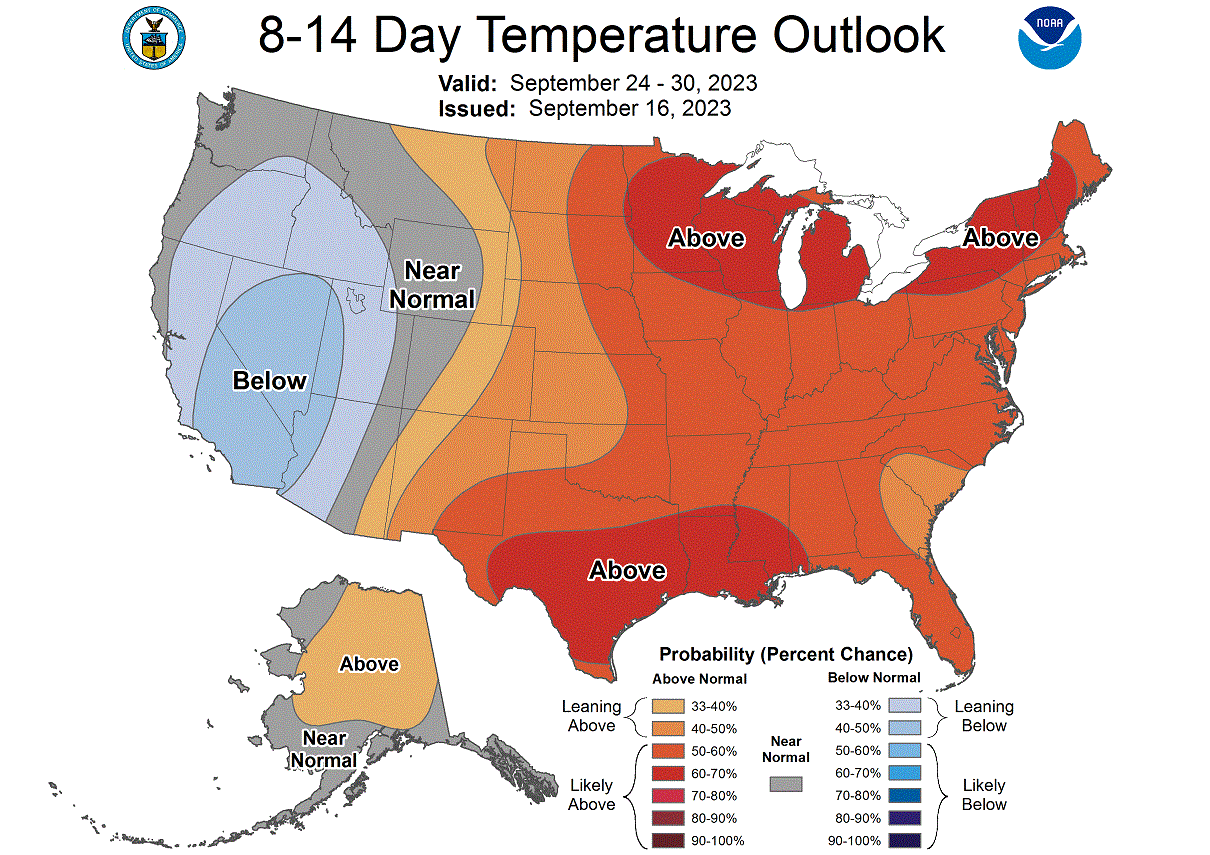
The NOAA precipitation forecast is also in agreement with the ECMWF ensemble forecast. More precipitation is forecast across much of the United States, except for the southwest.

But going into next month, we are also going deeper into the El Niño season. So, what are the latest monthly outlooks for the coming months?
OCTOBER WEATHER FORECAST
A forecast over two weeks in the future needs special treatment. We cannot use conventional tools, like we use for the short and mid-term forecasts.
In the monthly range, we usually look at trends and averages. For October and November, we will look at the monthly average and try to find the prevailing weather pattern idea.
We often use the ECMWF model, which is generally considered the most reliable. But no long-range/seasonal forecasting system can ever be called “reliable”. This is because we only look at trends and how the weather patterns are evolving on a large scale and over longer periods.
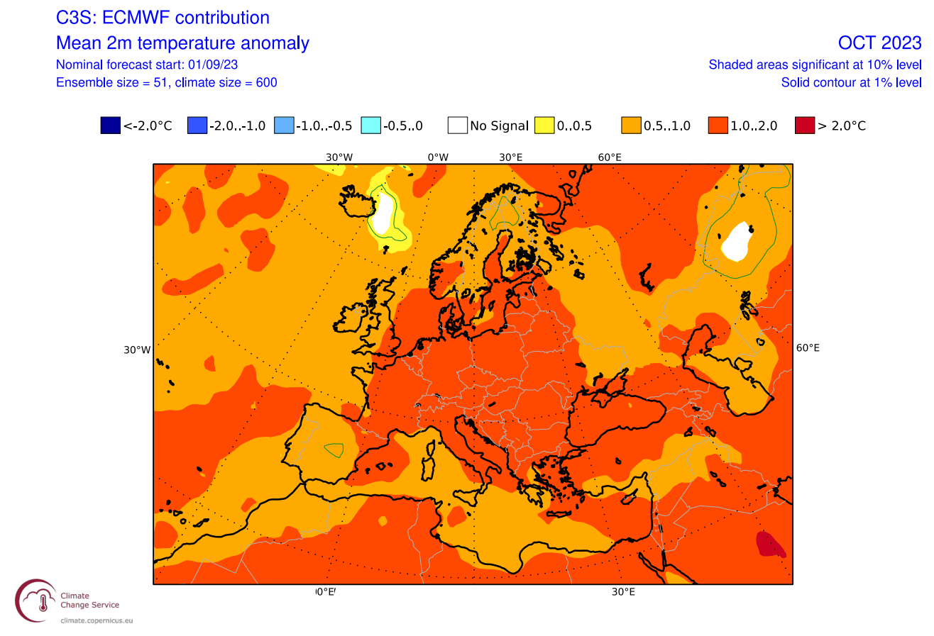
Looking at the pressure patterns first, we can see the Euro-Atlantic zone. A low-pressure system over the Atlantic means a warmer westerly and southerly flow dominates the continent. This mainly prevents any long-lasting mid-Autumn cold periods.

The temperature outlook is quite simple in such a pressure pattern. With high pressure and a southwesterly flow, much of the continent is under warmer weather than normal for this time of year.
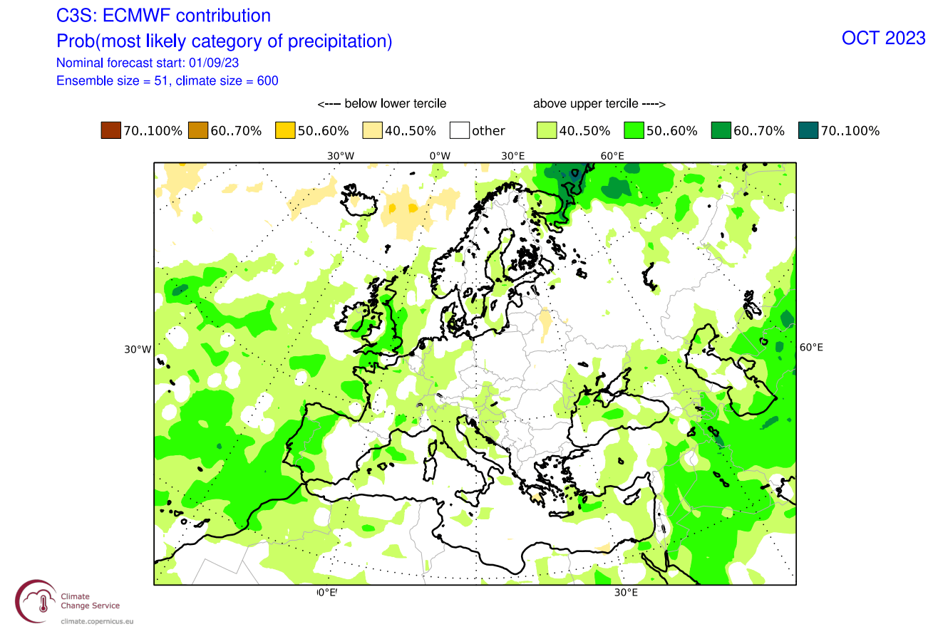
While the westerly and southerly flow might be warm, it can also be moist. And looking at the precipitation forecast, you can see more precipitation across much of the western and central parts under the warm and moist flow.
October is also the start of the snowfall season in higher elevations. But with a high-pressure system and a southerly flow, the snowfall forecast calls for less snowfall than normal across the continent.

NORTH AMERICA OCTOBER WEATHER FORECAST
Over North America, we get to see a slight problem. You can see that the whole map only shows positive pressure anomalies. That, of course, does not happen in nature. For that reason, we can look for gaps in the positive zones and indications of lower pressure.
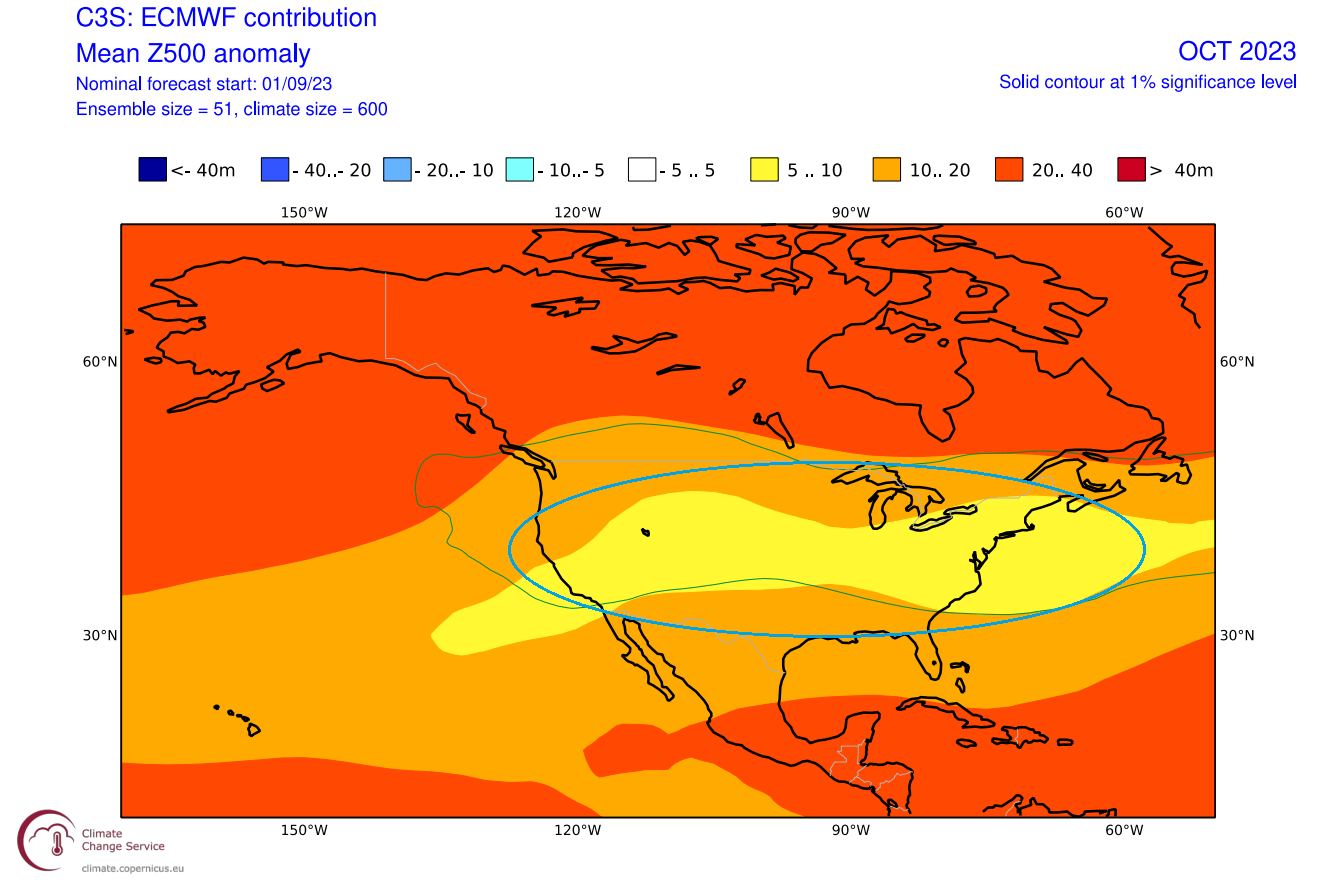
As you can see in the image above, a low-pressure zone is forecast over the United States by the ECMWF. If you remember the images earlier in the article, this resembles a typical El Niño Fall influence: a low-pressure zone over the United States and a high-pressure zone over Canada.
The corresponding temperature forecast is interesting. You can see warmer anomalies over Canada. There is an area of normal temperatures forecast across the United States, except for the far eastern and southeastern United States.

This is not a cold anomaly like in the historical El Niño analysis, but for a long-term pressure forecast, this is as close as it can get. It is a sign of a growing El Niño seasonal influence.
The precipitation forecast shows more rainfall over northern and eastern parts of the United States. This is an expected forecast from a low-pressure anomaly across the United States. But it does not mean a permanent low-pressure zone over the country. Instead, there are likely trailing low-pressure systems.

Looking at the snowfall anomaly forecast, we can actually see more snowfall across the northern Rockies. A slightly increased snowfall anomaly is also seen in the central plains. The limiting factor in October is, of course, the availability of cold air.

NOVEMBER WEATHER FORECAST
November is the last Fall month and the beginning of a transition period into the Winter season. This month, we expect a stronger El Niño influence, especially over the United States and Canada.
The historical El Niño analysis showed higher pressure and warm anomalies over Europe, which is also the current forecast pattern. It is hard to say whether that is the actual El Niño influence, but it can be analyzed after the season ends.
Looking at Europe first, we see the low-pressure zone over the northwest. But it is slightly more to the north than in October, so it supports a more westerly flow rather than southerly.
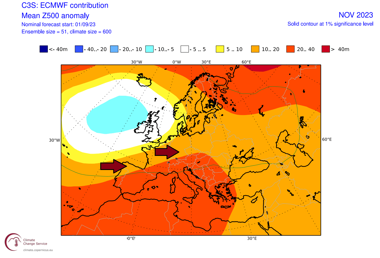
With the ridge still expanding from the south, it does not change much in terms of temperature patterns compared to the previous month. Most of the continent is still forecast to be under warmer than normal conditions. But with a more westerly flow, there is more room for an intermediate pattern swing.

The southwesterly flow from the Atlantic is warm and moist, supporting more rainfall than normal across much of northern and central parts.

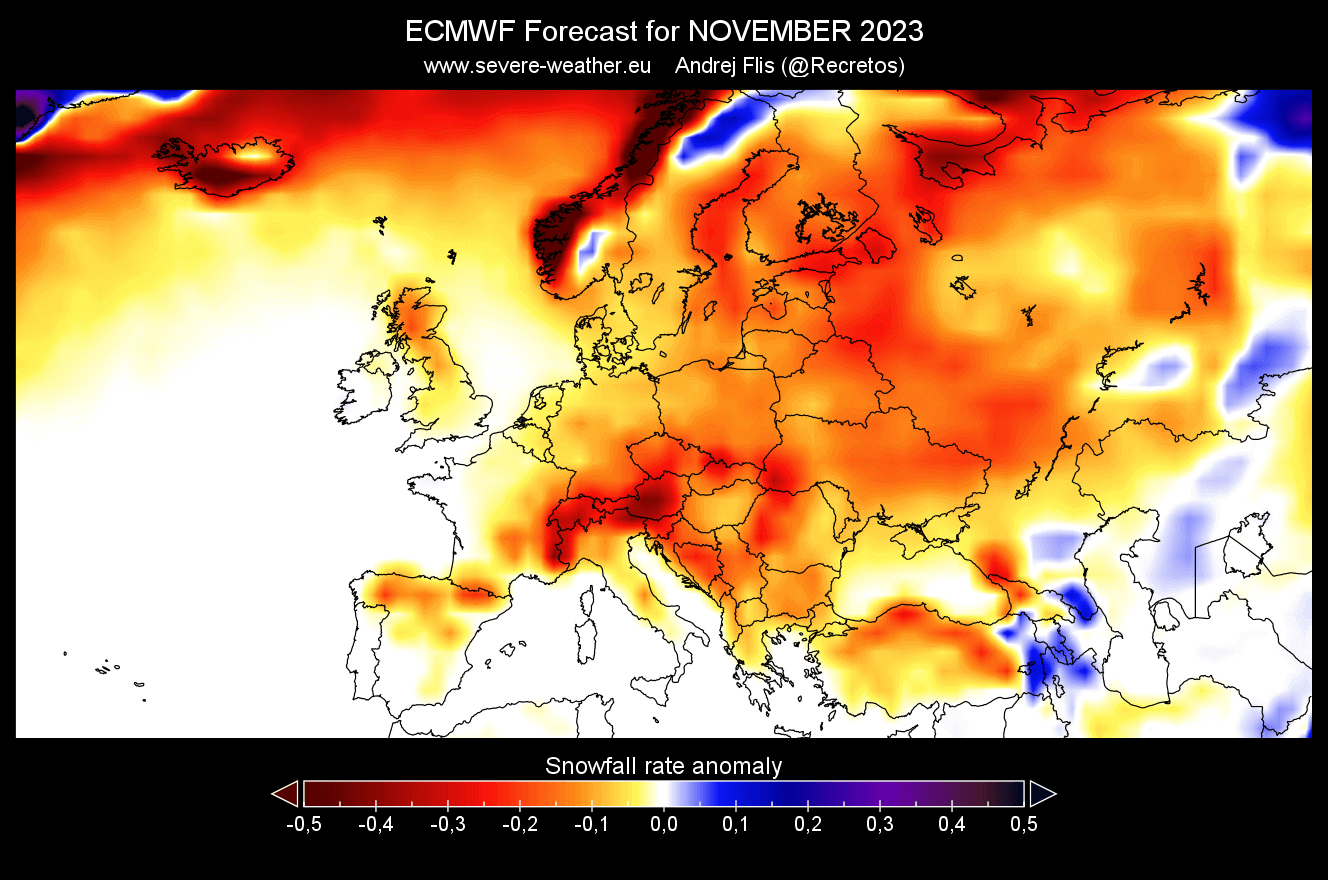
Snowfall events usually start to increase in November. But with a strong westerly pattern, the ECMWF snowfall forecast calls for less snowfall than normal for this month.
NORTH AMERICA NOVEMBER WEATHER FORECAST
Over North America, we can see a similar pattern to October, but perhaps a bit shifted to the west. The low-pressure zone is perhaps a bit more defined, as expected from the El Niño. This is a gradual transition into a winter El Niño mode, which means an amplified subtropical jet stream across the southern United States.

The temperature forecast is similar to the previous month. Warmer anomalies prevail over Canada and are expected to continue deep into Winter. But we still have an area of normal temperatures across the United States, thanks to the transitioning low-pressure systems.
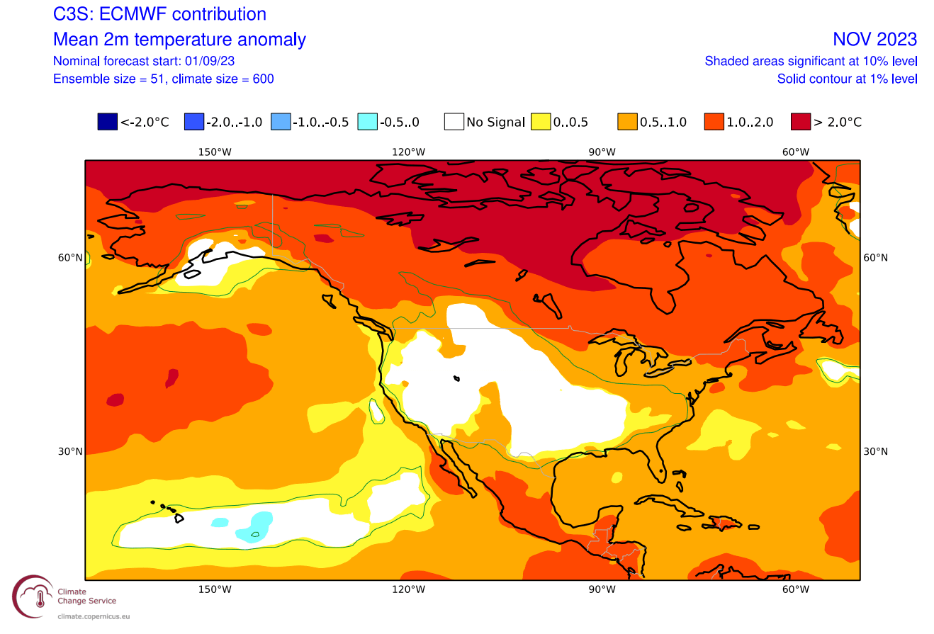
One note to the temperature forecast is that warmer anomalies over Canada do not mean an actual hot Fall. That is just the deviation from the long-term average. So, areas normally at freezing levels in late November are now above freezing.
That is the significance of these strong anomalies over Canada, for example, as it changes the snowfall dynamics and the availability of colder air in the United States.
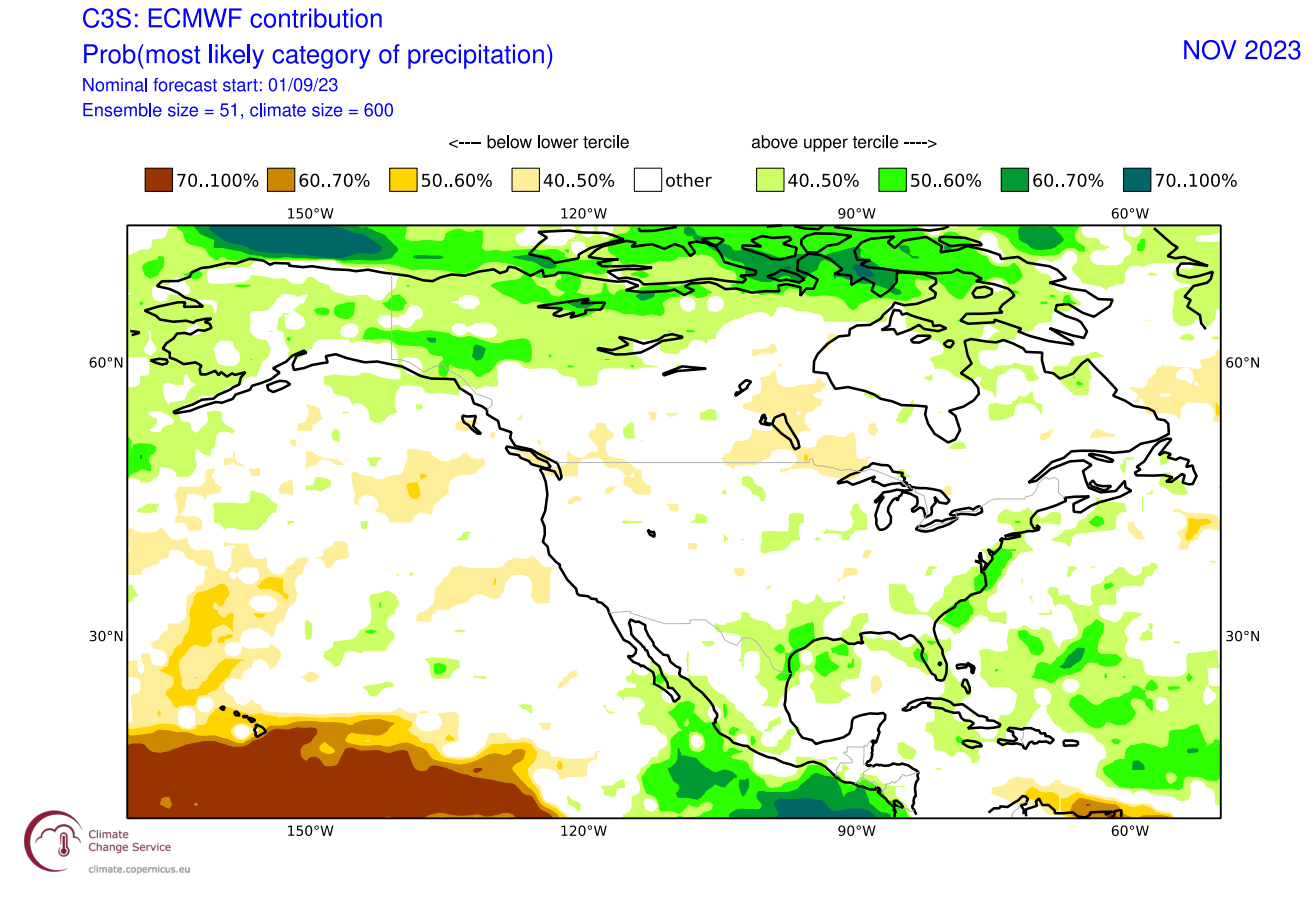
The precipitation forecast calls for more precipitation in the southern United States and over the east coast of the United States and northern Canada. Less precipitation is forecast across southern Canada and the northwestern United States.
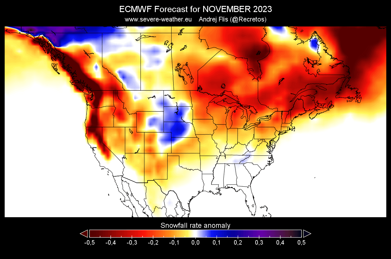
Looking at the snowfall anomaly forecast, we again see more snowfall than normal in the north-central plains. The rest of the United States and southeastern Canada is forecast to have less snowfall than normal for this month.
All in all, this looks to be a typical El Niño fall in the works. This tells us that El Niño has a good presence and connection with the atmosphere. That is of big significance going into the Winter 2023/2024 season.
We will release regular updates as fresh forecasts and data are available. So make sure to bookmark our page. Also, if you have seen this article in the Google App (Discover) feed, click the like button (♥) there to see more of our forecasts and our latest articles on weather and nature in general.
SEE ALSO: