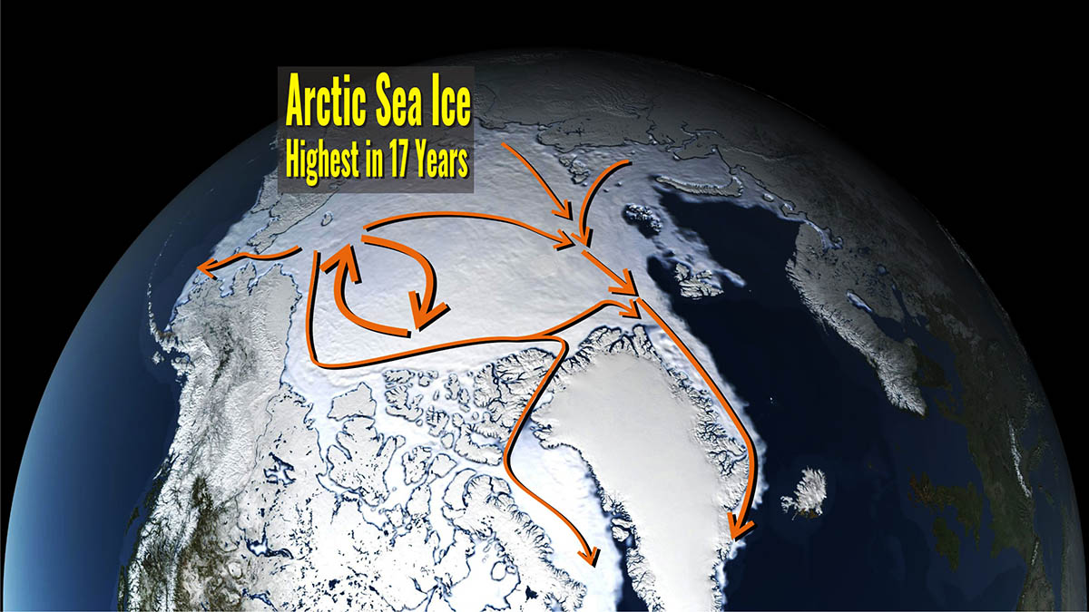
Arctic sea ice extent in January 2022 kept growing at a decent rate, and it is actually the highest in the last 14 years, according to the US Snow and Ice Data Center. A cool summer and autumn, particularly in the western Arctic Ocean, led to a rapid increase in sea ice early this year. A marked negative anomaly is instead affecting Antarctic coasts. Here, sea ice extent is close to that of 2017, which is the lowest on record.
ARCTIC SEA ICE JANUARY 2022
The Arctic sea ice extent actually grew faster than in the latest years. On average, in January its extent was 13.88 million square kilometers (5.36 million square miles) which is well within the interdecile range according to the Arctic Data archive System, NIPR.
The interdecile range is a measure of statistical dispersion of the values in a set of data. This means although below average, it is actually within the normal sea-ice inter-annual variability. The magenta line in the image below shows 1981 to 2010 average extent for that month.

At the end of January, the sea ice extent which defined the area of the ocean with at least 15% ice was well above 14 million square kilometers. But, what is most important, although such extent represents the sixteenth-lowest in the satellite record starting in 1979, it is actually the highest in 14 years, precisely since 2009.
This evidence shows the large natural variability in sea ice conditions, but indeed represents an important indicator of current weather and possible feedback in the upcoming Spring season. Nevertheless, we want to stress that winter ice extent is a weak indicator of what the ice extent will look like this coming September when we will face the annual minimum.

In the video we set below, you can track sea ice extent evolution in the Arctic updated every 5 days from January 1 to January 31. Arctic sea ice grows constantly but remains below normal mostly in the Sea of Okhotsk and in the Barents Sea.
Although sea ice is relatively extensive compared to recent winters, it remains relatively thin. In the Barents-Kara Seas extent is close to normal. Below normal sea ice in the Barents-Kara seas favors cold temperatures in Central and East Asia, however, this topic remains controversial. Further down we will look at the sea ice extent in each and every sector of the Arctic.
Along with sea ice extent, in the video, above we have also shown the mean temperature of the ice and the surface of the sea based on satellite observations. This datum has a great influence on the exchange of heat between the surface and the atmosphere, and thereby also the rate of increase of the sea ice volume.
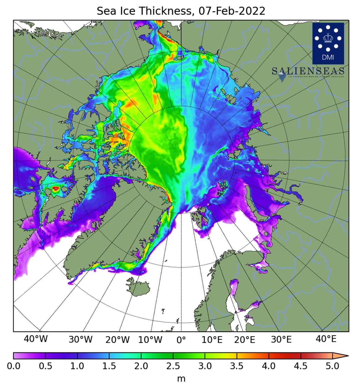
The thickness of ice, and thus the volume, appear at the end of the video. The animation and graph illustrate the sea ice thickness in the Northern Hemisphere, excluding the Baltic Sea and the Pacific. The data are available thanks to the DMI’s model calculations through the Polar Portal
The image below shows sea ice extent and thickness on February 7, 2022.
WHAT SEA ICE IS?
Sea ice means all sorts of ice that form when seawater freezes. Ice in the ocean that is not fast ice refers to drift ice, and, if the concentration exceeds 70%, it is called pack ice. When sea ice concentration is lower than 15% this is considered as open water, and the boundary between open water and ice is called the ice edge.
Ice extent in the Arctic Ocean grows throughout the winter and peaks in March. In September the extension reaches its minimum, which is generally only around one-third of its winter maximum. In order to get a proper picture of the sea ice state, there is the need of determining both extents and volumes. Such numbers primarily include the ice thickness, generally linked to the age of the ice. In the image below, Arctic sea ice climatology from 1981-2010 by the Snow and Ice Data Center, University of Colorado, Boulder.
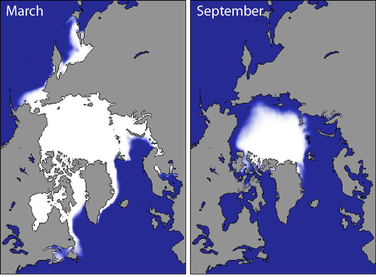
As we stated a few paragraphs above, winter ice extent is a weak indicator of what the ice extent will look like this coming September when we will face the annual minimum. The seasonal cycle of Arctic sea ice is characterized by the maximum annual extent in March, decreasing through spring and summer to an annual minimum extent in September.
Since 1979 it has been possible to monitor sea ice by satellite. At present, We have 43 years of reliable information on the extent of the sea ice cover. The sea ice had continuously diminished and particularly since the end of the 1990s. Nevertheless, the winter trend is different from the summer trend.
In the image below the Arctic sea ice extent development at the end of the winter season (March maximum) and by the end of the summer (September minimum)

As global temperatures rise, Arctic sea ice extent, and volume too, have shrunk by an average of 13.4% per decade since 1979. The ice that remains is often thinner and more fragile than before, making it more vulnerable to melting the following year.
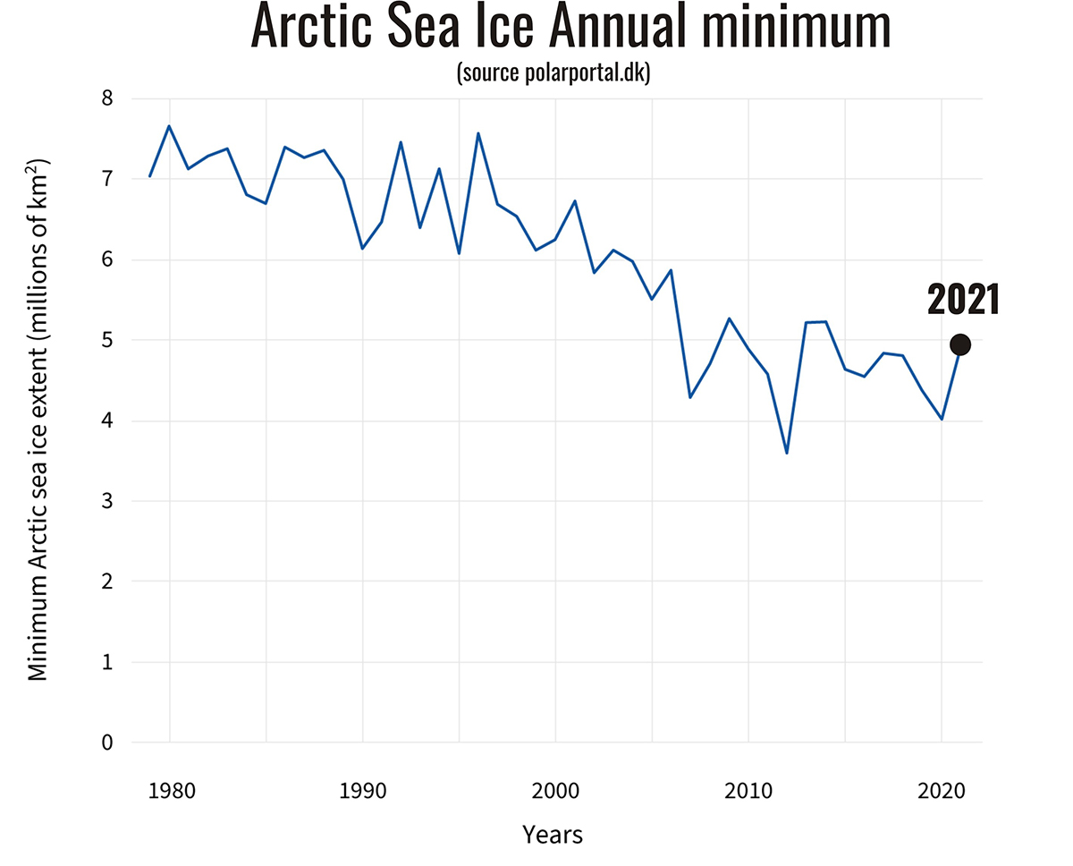
The animated time series below in the video we set for you, we present the annual Arctic sea ice minimum since 1979, based on satellite observations. After this, a captivating graphic by Zachary Labe shows changes in annual mean Arctic sea ice extent based on NSIDC Sea Ice Index v3, and air temperature anomalies from Berkeley Earth Surface Temperature over the satellite era.
THE CURRENT ANOMALY IN THE GENERAL CONTEST
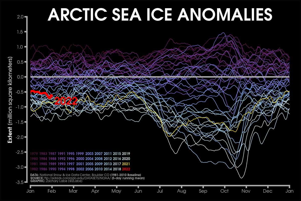
Looking more in detail to the current Arctic Sea Ice anomalies referred to the long-term 1979-2022 monitoring, we use the image below credits Zachary Labe. The plot shows the extent anomalies source satellite-era, NSIDC, DMSP SSM/I-SSMIS calculated using a 5-day running mean from a climatological baseline of 1981-2010. The year 2022 updated to February 2 is shown using a red line, while 2021 is highlighted in yellow.
Although lower by about 0.5 million square kilometers, the Arctic Sea Ice extent is not as bad as in the very last winter season, and definitely higher of 2021. After a rapid melting occurred from late May to early July 2021, the anomaly reduced through August, eventually raising again in September and early October.
This year, extent reached its minimum on September 16th but it was far from the lowest on record and was actually just the 12th lowest in the past decades. A colder than average weather in the western Arctic Ocean slowed down sea ice from melting especially in the Canadian and Alaskan regions.
Nevertheless, the 2021 minimum sea ice extent was around 4.724 million square kilometers, roughly 1.6 million square kilometers lower than the long-term mean. Not only air temperature, but sea temperature as well were colder than normal in the western Arctic sector last summer. This was certainly a favorable trigger contributing to fast and earlier freezing in this Arctic sector when the fall season started.
At this point of the season, the Arctic sea ice extent is still growing and it will continue to do so until about mid-March. Nevertheless, it remains below normal mostly in the Sea of Okhotsk and, recently, in the Barents Sea. Overall we saw that sea ice is relatively extensive compared to recent winters, though it remains relatively thin.
In the Chucky and Kara Seas extent is close to normal. Below normal sea ice in the Barents-Kara seas apparently favors cold temperatures in Central and East Asia, however, this topic remains controversial. The extent is recently close to normal in the Greenland sea too, thanks to a rapid increase in the second part of January triggered by a favorable weather pattern.
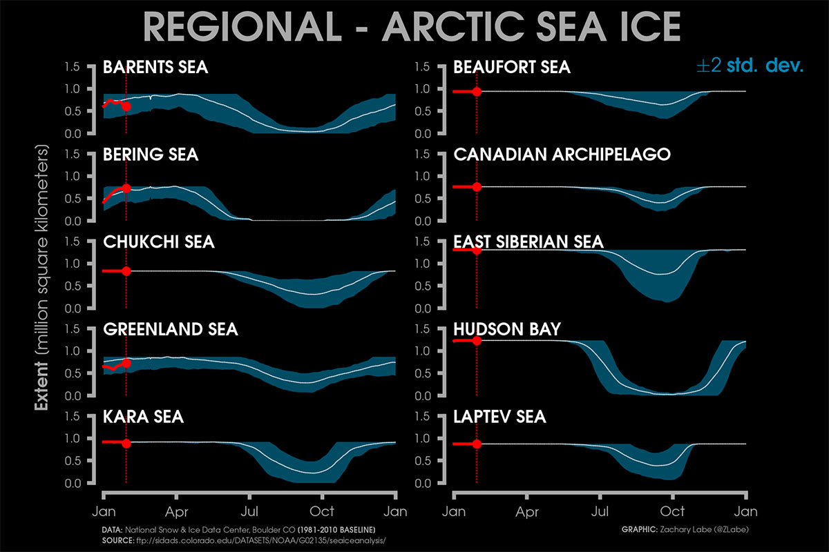
In the image above, (updated February 7, 2022) the current regional Arctic sea ice extents thanks to NSIDC Sea Ice Index v3 in addition to 2 standard deviations from 1981-2010 mean. In particular, the Greenland Sea faced a fast increase in Sea Ice extent in the second part of January.
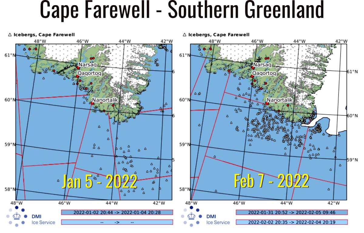
The image below shows how sea ice reached Cape Farewell in Southern Greenland in the last weeks and how the number of icebergs increased. Until mid-January, the east coast was free of ice. Pure white areas refer to sea ice, while the number of icebergs is detected within the light- and dark blue area and presented as small triangles.
HOW WAS THE WEATHER IN THE ARCTIC IN JANUARY
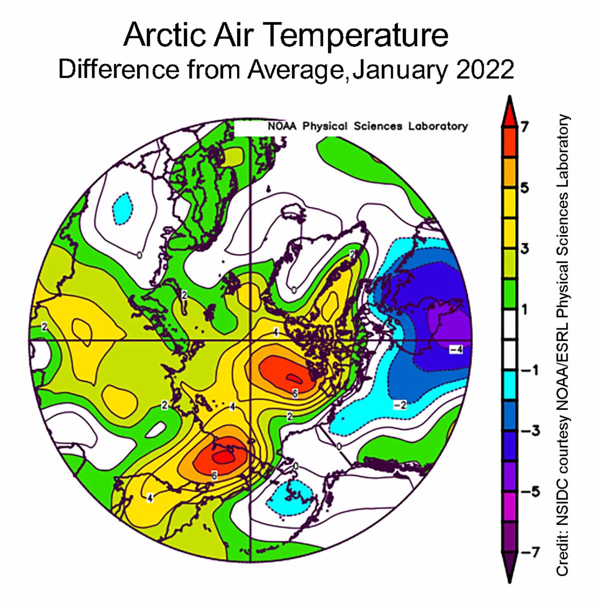
Air temperature in January at the 925 hectoPascal level, corresponding to about 700 meters or 2,500 feet above the surface, was above average over all of the Arctic Ocean. Temperatures were up to 7 degrees Celsius (13 degrees Fahrenheit) higher than average north of the Canadian Archipelago, with smaller differences in other sectors.
This plot below shows the difference from average air temperature in the Arctic at the 925 hectoPascal level, in degrees Celsius, for January 2022. Higher than the average air temperature in yellow and reds, blues and purples indicate lower than average values. Both temperature and pressure plots are credits NSIDC courtesy NOAA Earth System Research Laboratory Physical Sciences Laboratory
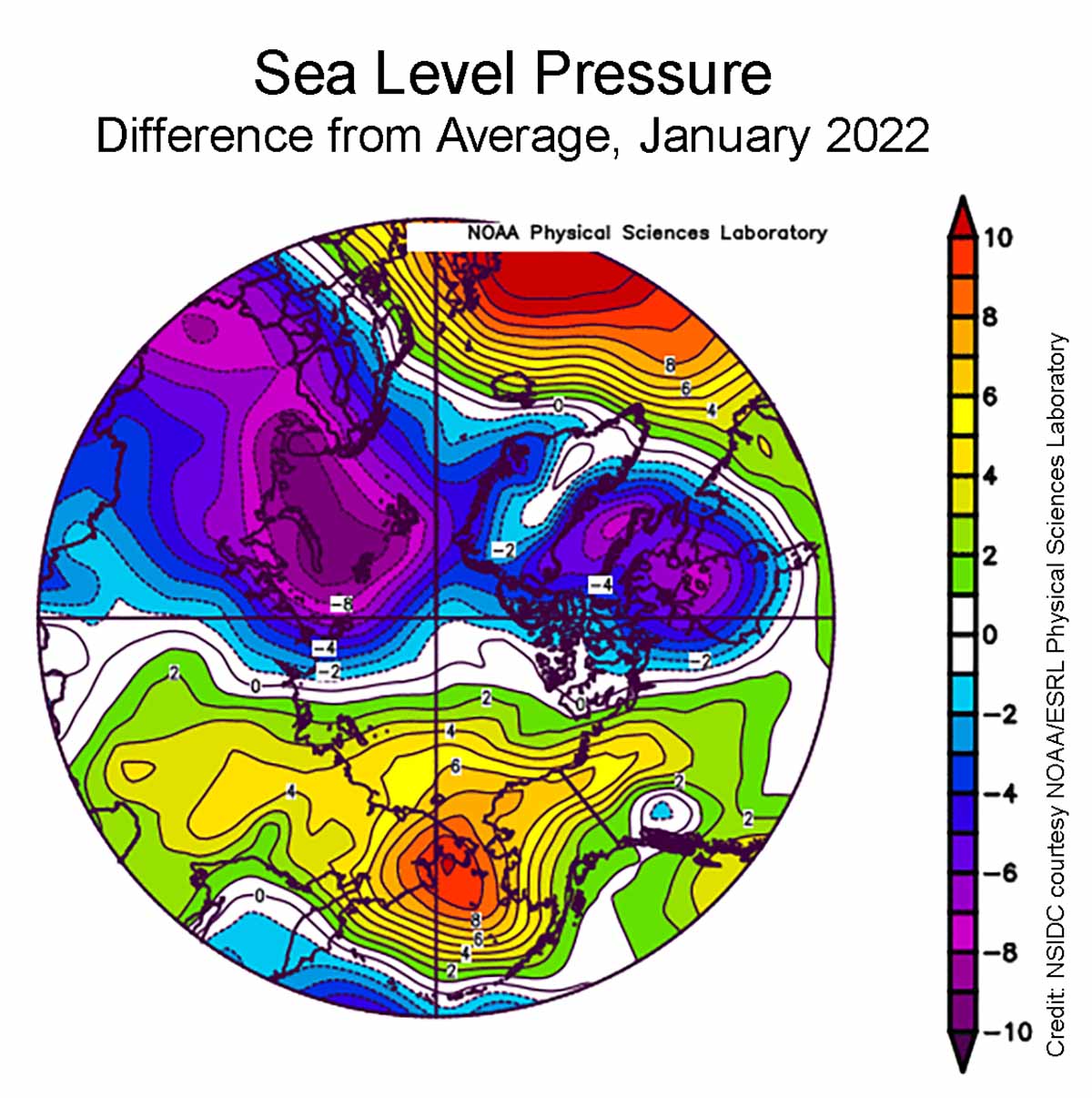
Sea level pressure pattern January in the image below featured the typical Siberian High pressure usually forming over eastern Siberia in the cold season. Nevertheless, sea level pressure was up to 8 hectoPascal above average over eastern Siberia, extending through the Bering Sea and into western Alaska.
At the same time, below-average sea level pressure was observed over Eurasia and Hudson Bay. Typically, when the Siberian High is strong, an advection of warm air from eastern Europe leads to mild conditions over the Kara and Laptev Seas. The Siberian High was also accompanied by low pressure south of the Aleutians.
This pattern triggers winds transporting cold air that boosted freezing conditions in the Bering Sea and pushed ice southward, leading to a higher sea ice extent in the Bering sector.
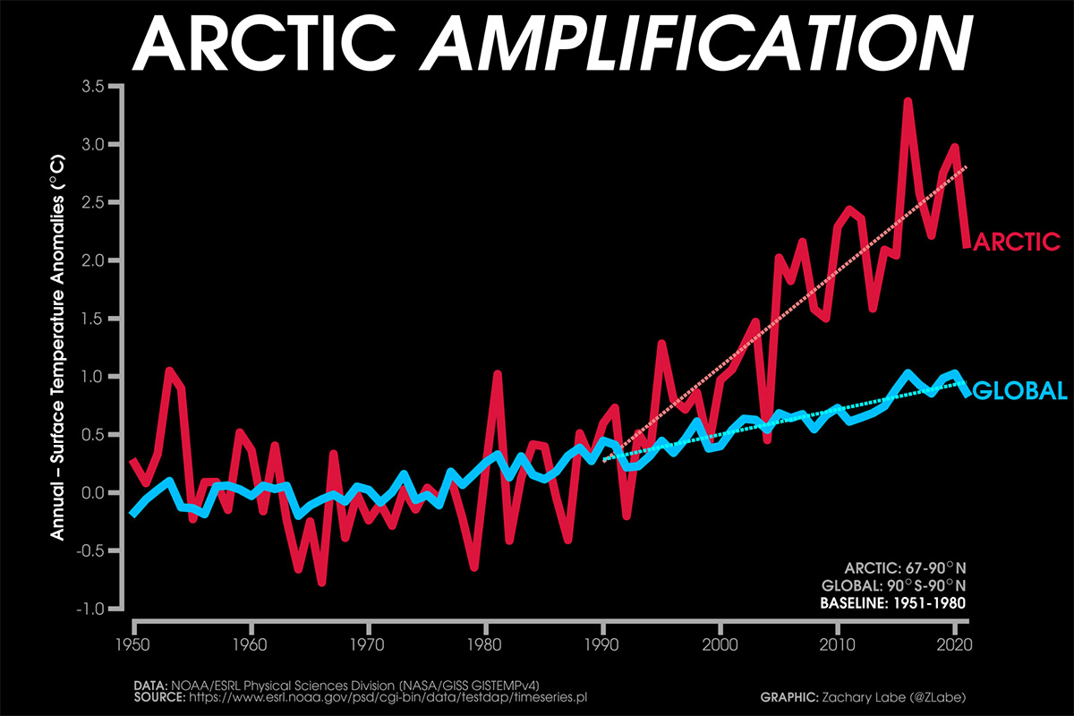
As we saw above, the temperature in the Arctic dramatically increased, and the warming here drastically enhanced than globally. This is mainly due to the so-called Arctic Amplification. Arctic Amplification refers to the enhancement of near-surface air temperature change over the Arctic relative to lower latitudes.
These mechanisms include both local feedback and changes in poleward energy transport. Temperature and sea ice-related feedbacks are especially important for Arctic Amplification since they are significantly more positive over the Arctic than at lower latitudes. Changes in albedo from a frozen light sea surface to a free-of-ice and darker sea surface allow positive feedback affecting mean and extreme temperatures in the Arctic.
The extent of sea ice in the Arctic has important implications for global climate and weather, both in North America and Europe. The Sea Ice Extent in the Arctic this year is in contrast with what is happening globally, and in particular because the Antarctic sea ice is in sharp decline.
Although stable above the long-term average from March to the end of August, Antarctic Sea Ice started its rapid decline in September. At present, the negative anomaly is the second-largest ever recorded.
SUMMER 2022 IN ANTARCTICA
The Arctic and Antarctic are geographic opposites, and not just because they stand on opposite ends of the Earth’s globe. They also have opposite land-sea arrangements. In the Arctic, continents surround an ocean, while in Antarctica the continent is surrounded by oceans.
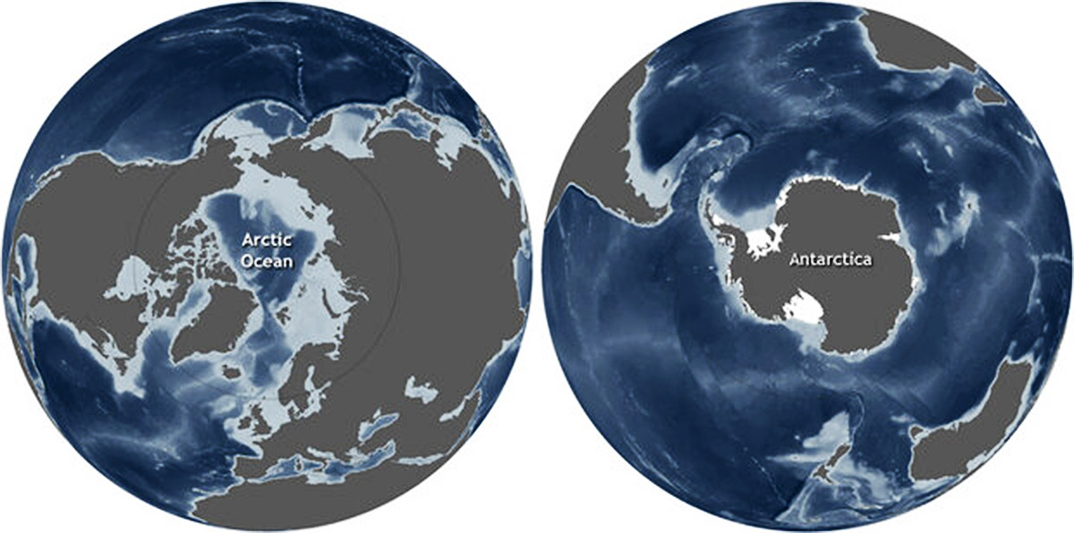
These differences in the arrangement of land and water contribute to differences in each polar region’s climate, oceanic and atmospheric circulation patterns, and sea ice.
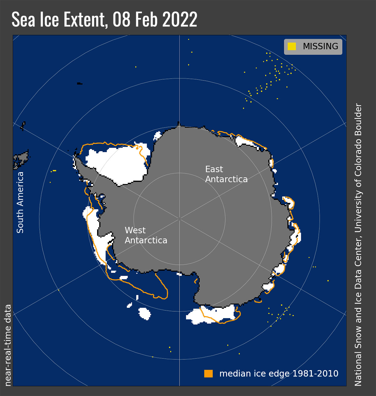
Antarctica is experiencing definitely warmer temperatures so far this year. As a consequence, in January sea ice extent was the second-lowest in the 44-year record. The image below shows the Antarctic sea ice extent at the beginning of February, along with daily ice extent data for five previous years.
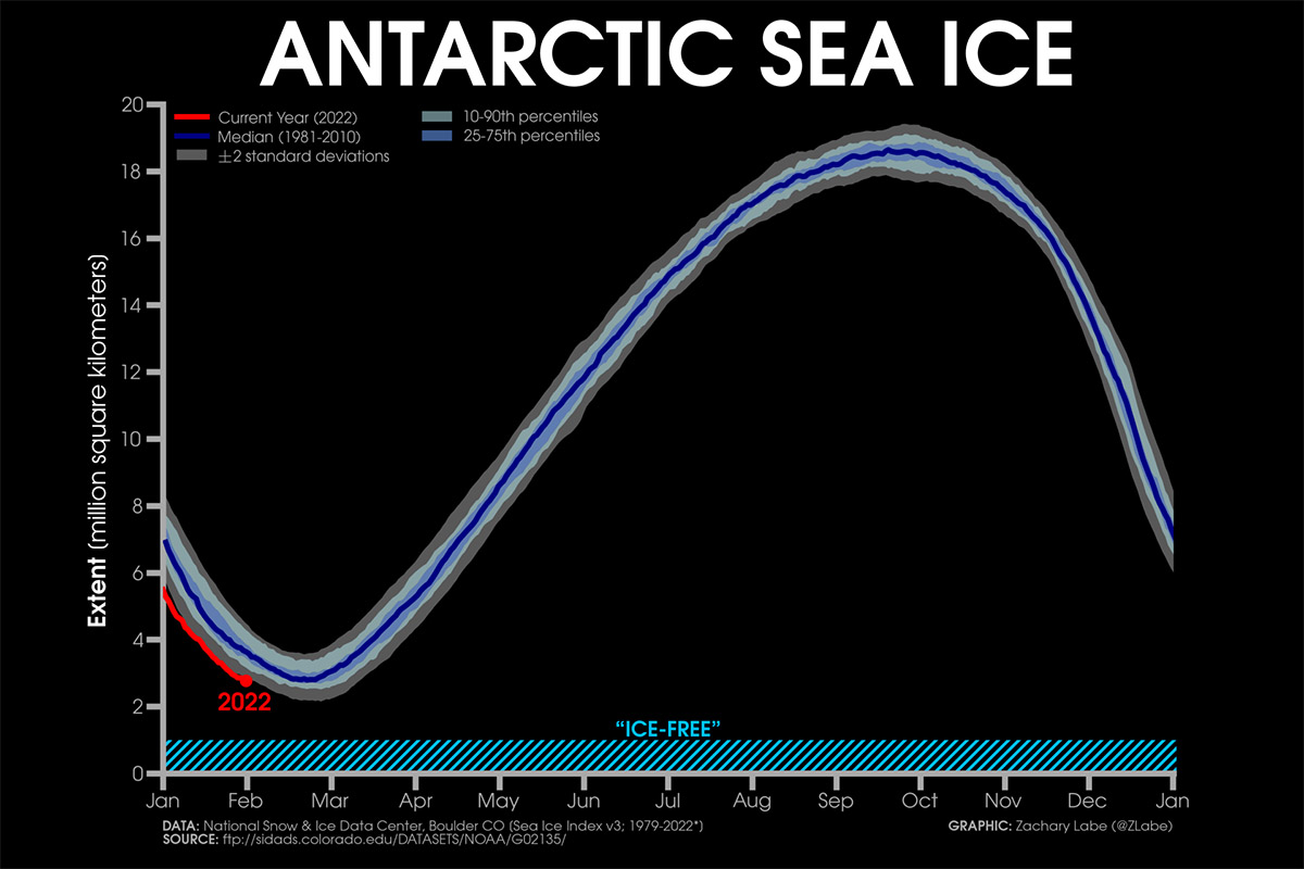
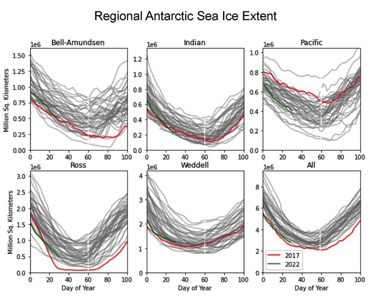
In these days sea ice extent is running roughly at the same pace of season 2017-2018. Regionally, ice extent is tracking below levels observed for 2017 in the Indian and Pacific sectors, but above levels for that year in other sectors.
In 2017, only the Ross Sea recorded a very low extent, therefore it was the main driver of the record low hemispheric sea ice extent. Likewise, in 2021-2022 summer none of the specific regions have record low extents, but all are well below average leading to the second-lowest Antarctic sea ice in the satellite record, above 2017.
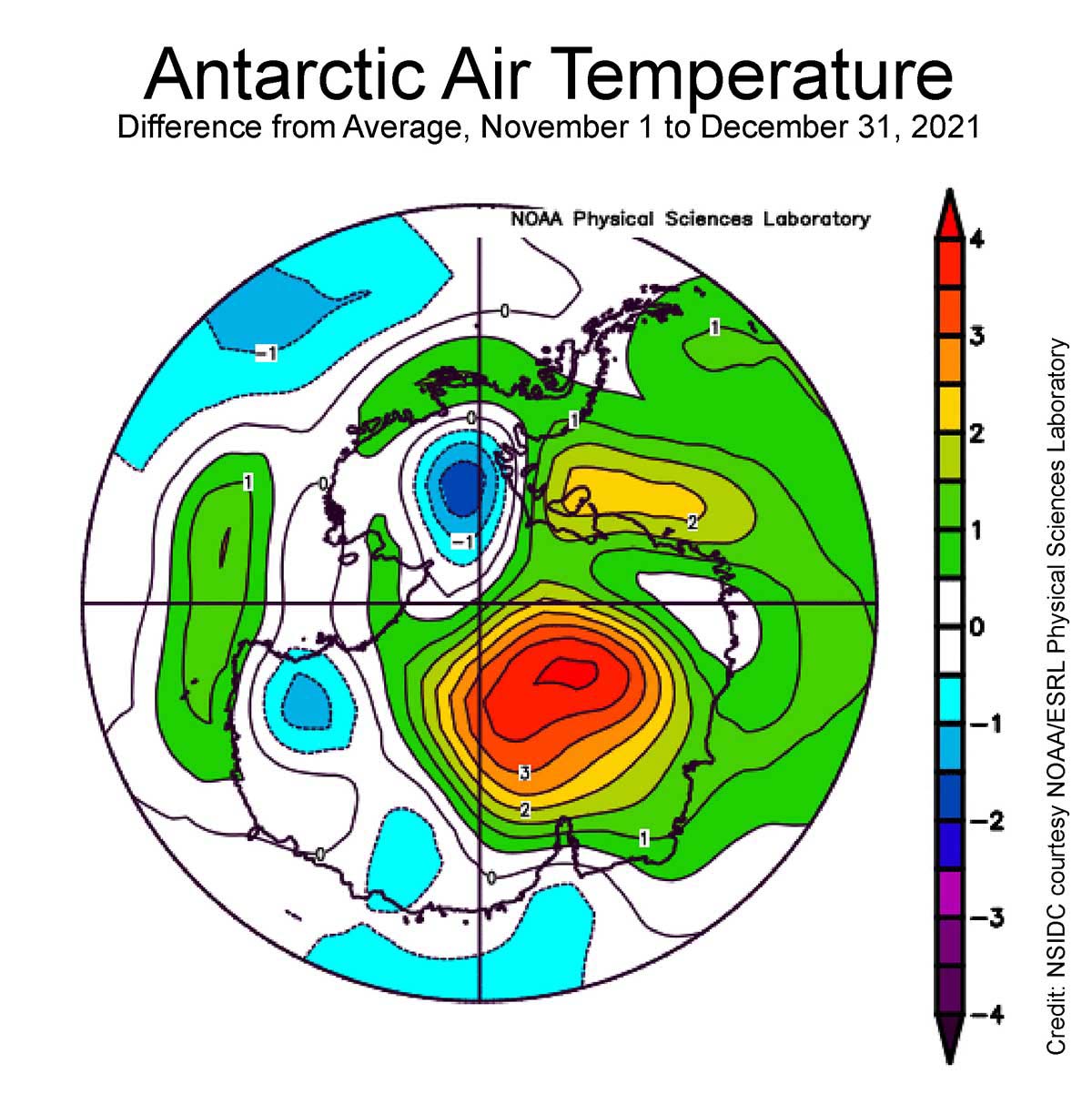
In the image below the average temperature for November and December shows a massive positive anomaly up to 4 °C in a large part of Antarctica. The image shows the departure from mean air temperature, in degrees Celsius, at the 925 hPa level. Yellows and reds indicate higher than average temperatures; blues and purples indicate lower than average temperatures.
The interior of the East Antarctic Ice Sheet was rather warm but does not approach the melting temperature. On the other side, in coastal areas temperature approaches more easily and frequently the melting point during the summer season.
In the image below, the number of melt days between November 1 – January 9, 2022. The average values and ranges for the 1990 to 2020 reference period. Credit L. Lopez, NSIDC, M. MacFerrin, CIRES, and T. Mote, University of Georgia. The northern part of the Antarctic Peninsula experienced the higher numbers of melt days
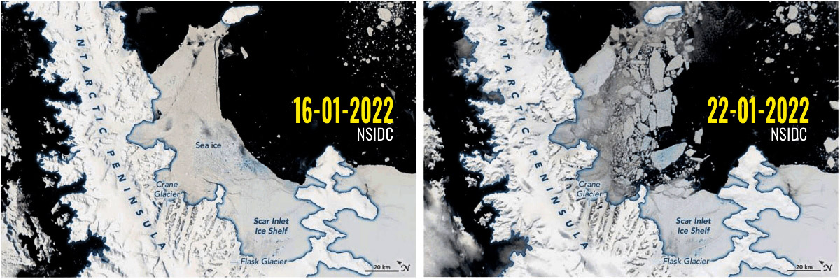
The northern part of the Antarctic Peninsula was affected by a series of recursive melting peaks that occurred in December and in January, causing extreme melting well above the long-term average. Such events have been amplified by severe foehn wind events.
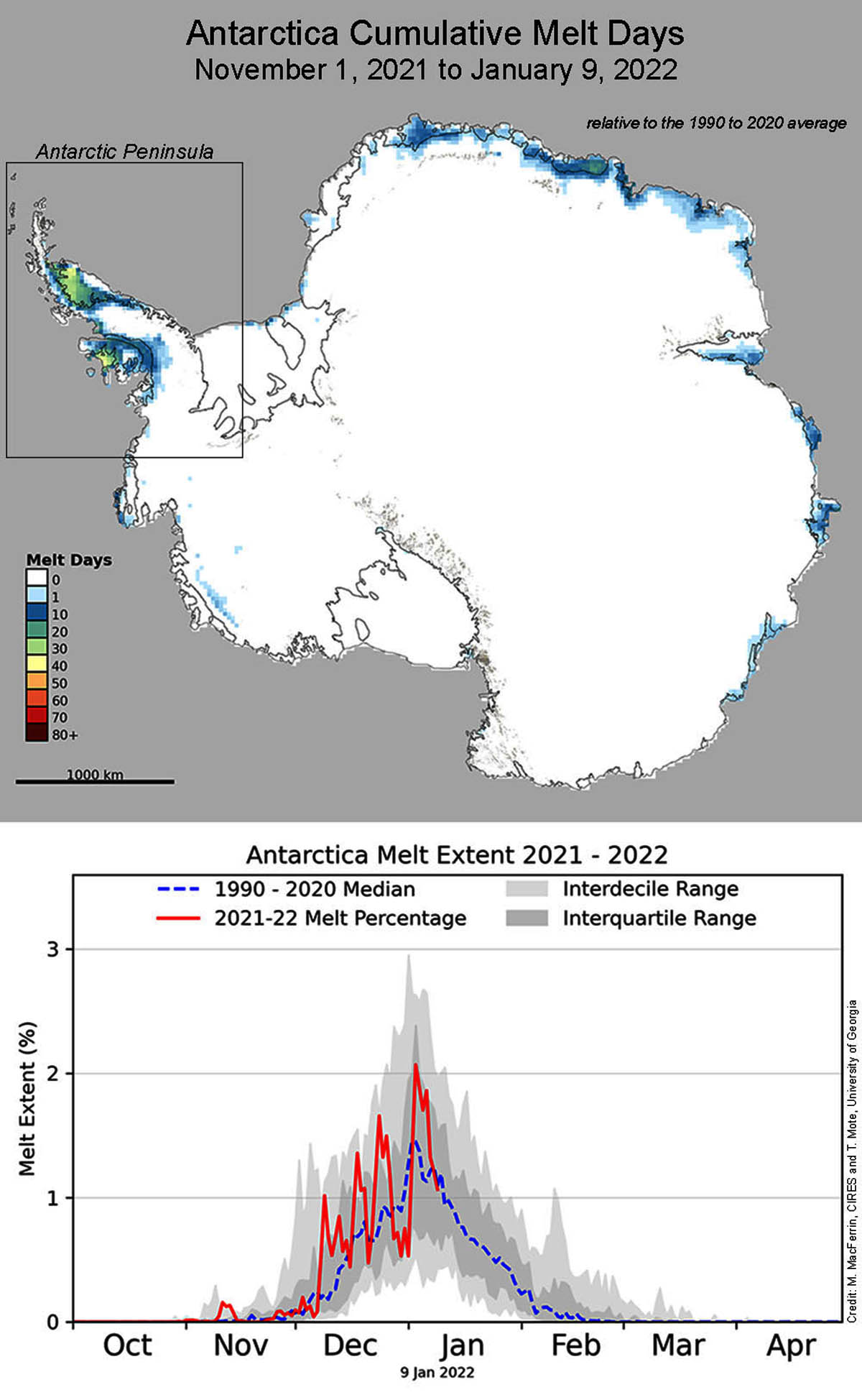
As a consequence, multiyear fast ice in the Larsen B embayment, in place continuously since early 2011, showed widespread meltwater flooding with some deeper ponds and some areas drained by narrow fractures. Between January 16 and the 21st, the sea ice of the Larsen B ice shelf, linked to the Antarctic Peninsula’s, crumbled and disintegrated.
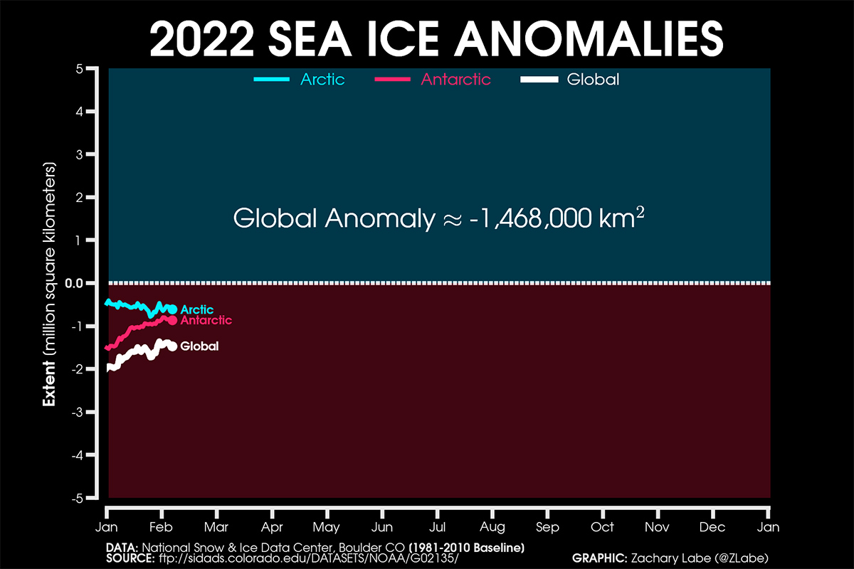
Both the Arctic and Antarctic Sea Ice extent push the global anomaly at -1.468 million square kilometers or about 0.567 million square miles. In the image below the current sea ice extent anomalies for the Arctic and Antarctic, source NSIDC, DMSP SSM/I-SSMIS F-18 edited by Zachary Labe. Anomaly is based on 1981-2010 climatology.
We will keep you updated on this and much more, so make sure to bookmark our page. Also, if you have seen this article in the Google App (Discover) feed or social media, click the like button (♥) to see more of our forecasts and our latest articles on weather and nature in general.