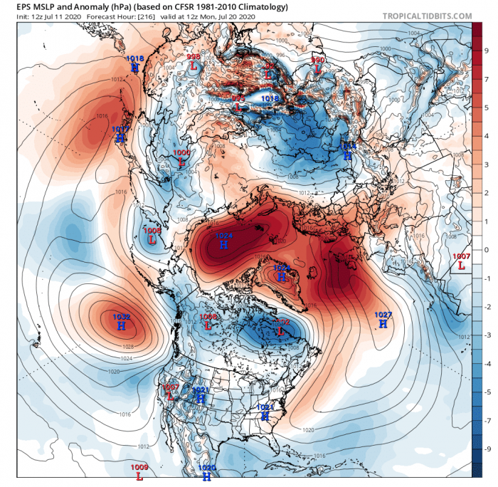
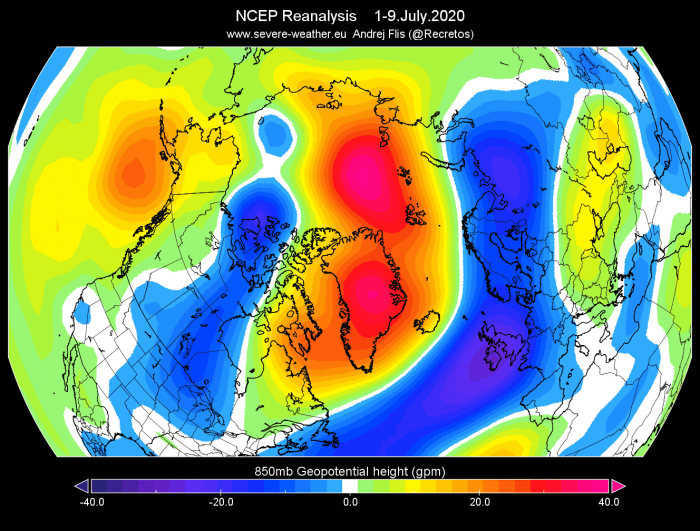
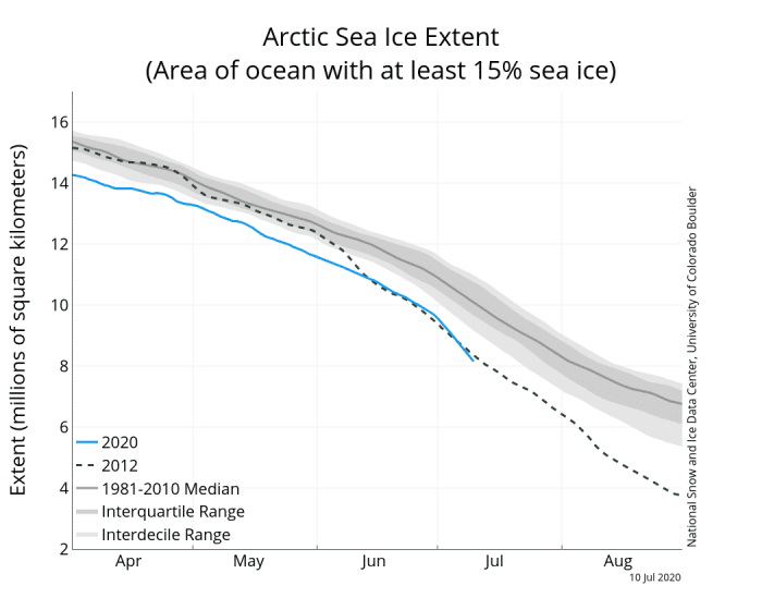
The Arctic sea ice melts every year from spring to early autumn. This year, the summer melt season is very strong. Currently, the Arctic sea ice extent and volume are near or at record lowest values in the modern records. That is largely due to the persistent high-pressure system over the Arctic Ocean.
A strong, anomalous high-pressure system has been dominating the Arctic Ocean since late June. It has become a semi-permanent feature by now and is forecast to remain over the Arctic Ocean for at least two more weeks.
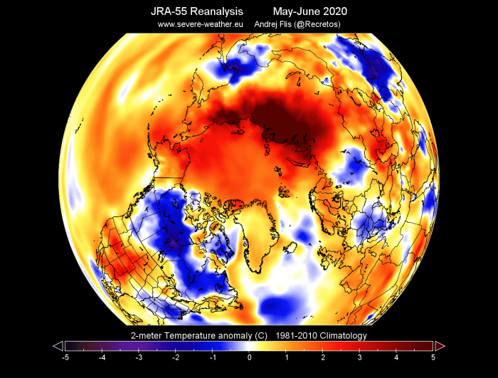
A high-pressure system has been previously present over the Siberian sector since at least early May, and has contributed to record high temperatures over Siberia and also the surrounding Polar regions. Below is the temperature anomaly analysis for May and June. It reveals the Siberian “hotspot” and the warmer than normal Arctic Circle.
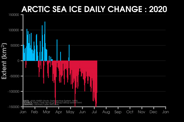
Persistent high-pressure systems over the Arctic ocean are a real problem for the ice cap in summer. There is 24 hours of daylight over the North Pole during summer, and high-pressure areas provide clear, cloudless skies, accelerating ice melt without a break. The graphic below shows the daily Arctic sea ice loss. We can see since early July, that the daily ice melt rate has increased, coinciding with the onset of the strong Anticyclone.
CURRENT ARCTIC ICE
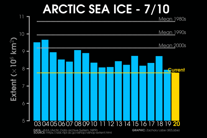
The latest data reveals rapid sea ice loss over the Arctic. The first graphic below shows the rapid reduction of the Arctic sea ice extent since the beginning of July. The second graphic (by Zachary Labe) is a comparison of the current sea ice extent with the past years, where we can see that 2020 is currently at the lowest extent for the first half of July.
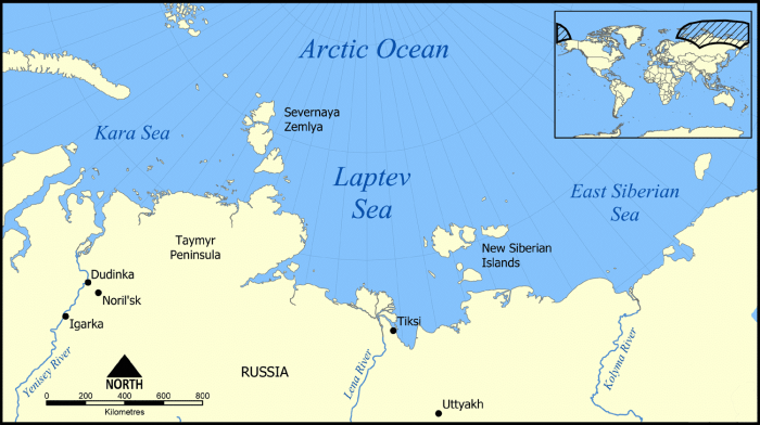
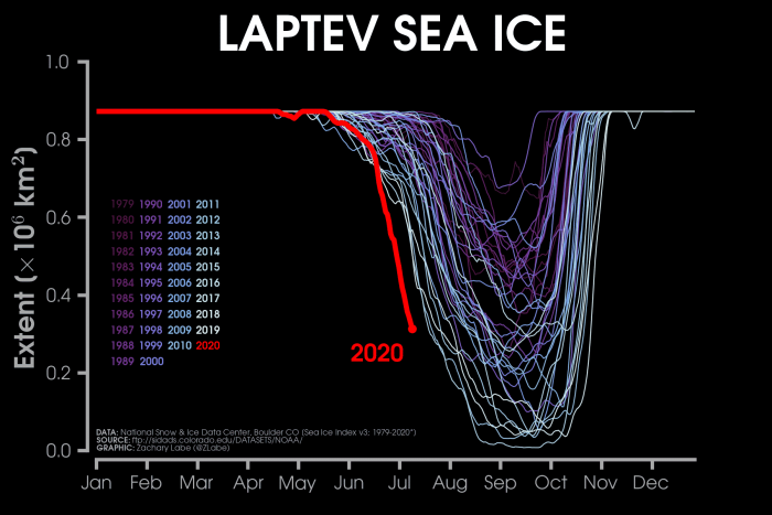
The most unusually rapid melt was of course in the Laptev Sea, which was directly impacted by the record warm temperatures in Siberia. The current sea ice extent there is around the normal levels for August.
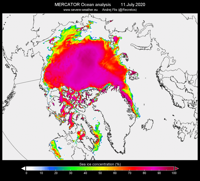
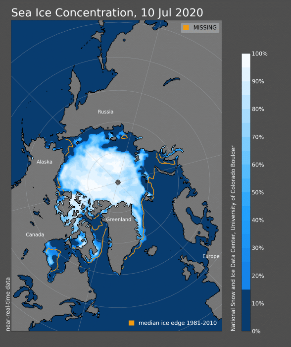
High-resolution analysis from the MERCATOR system shows the latest sea ice concentration. The sea ice extent and concentration are well below normal, especially east of the North Pole.
The high-resolution video analysis below shows the sea ice melt and concentration change since March. Take notice of the faster melt rate from mid-June onwards.
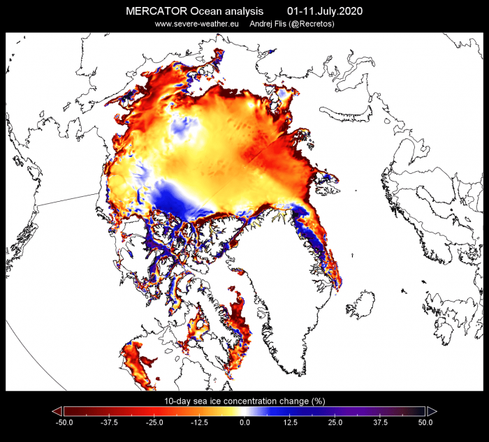
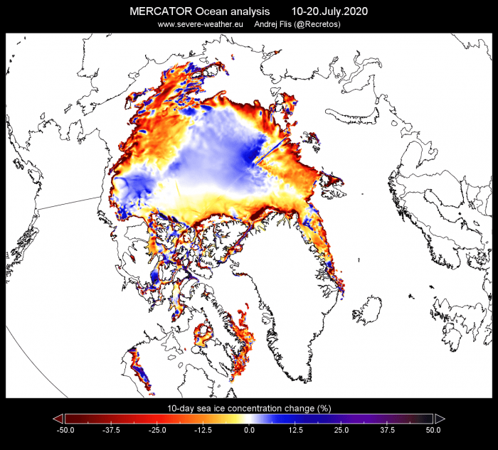
Looking at the previous 10 days and the next 10 days (forecast), we can see most of the ice loss was in the outer regions. The second map which shows the concentration change forecast actually shows an increase in concentrations over the central region. That is likely due to the transport of ice towards the central region, compacting the ice, and increasing the concentration.
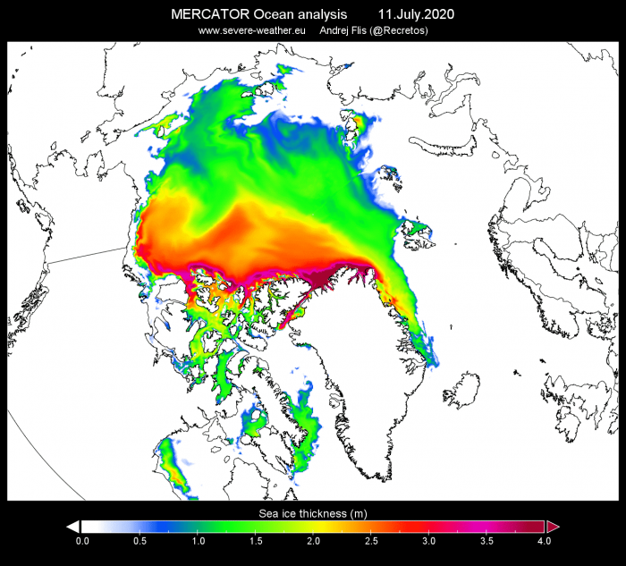
Sea ice concentration is directly related to thickness. Contrary to popular belief, the Arctic sea ice is rather thin, ranging from a few centimeters to only a few meters at best. If we could reduce the size of the Arctic ice cap down to that of a sheet of paper, the ice cap would be several hundred times thinner than a typical A4 paper sheet!
Our high-resolution video of sea ice thickness shows the change from March to July. We can nicely see just how much motion there is in the ice cap and how quickly it melted since June.
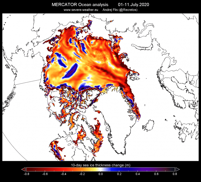
The first 10 days of July have featured quite an extensive thinning of the ice cap. The thinning rate is set to reduce slightly in the coming 10 days, but it will still significantly impact the total volume of the sea ice.
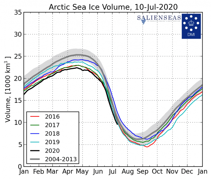
Currently, the sea ice volume is at record low levels for this time of year. It will continue to decline, but will likely be around a similar or slightly lower level as last year by the end of the month.
TRANSPOLAR ICE DRIFT
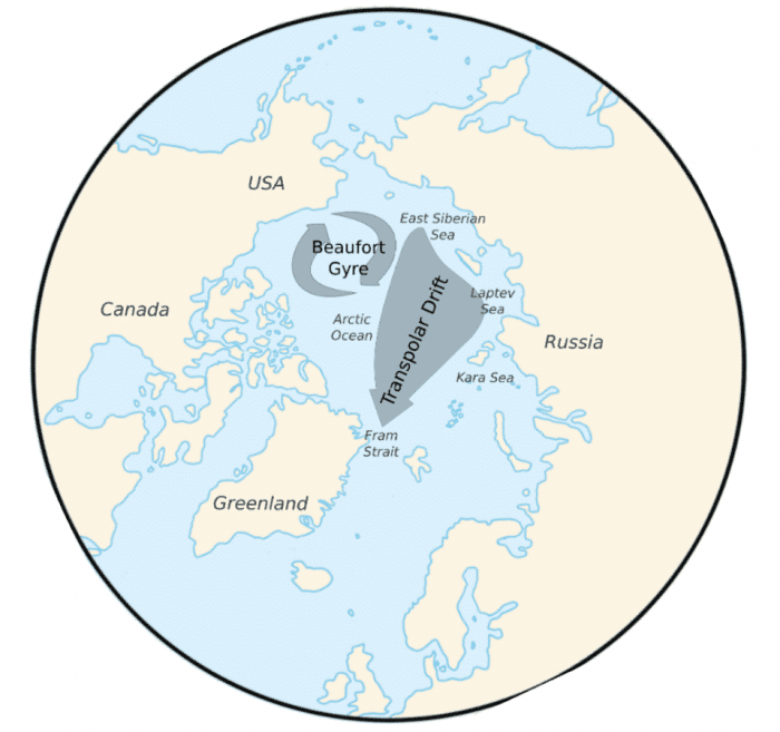
The Transpolar Drift Stream is a major ocean current of the Arctic Ocean, transporting sea ice from the Laptev Sea and the East Siberian Sea towards Fram Strait. It flows across the entire polar region. It is primarily driven by the wind and responds to the yearly and decadal weather pattern changes. The graphic below shows the average direction of the Transpolar Drift Stream (TDS).
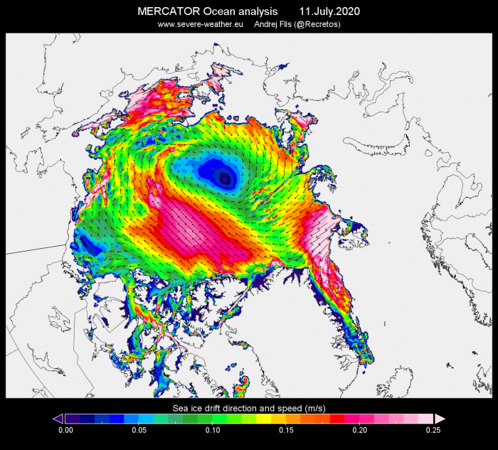
The current high-resolution analysis of the sea ice drift, reveals that the direction of the drift is almost the opposite. The sea ice has a clear clockwise rotation. It directly reflects the Anticyclonic air movement of the strong high-pressure system over the Arctic Ocean. It is likely that the change in the pressure systems over the Arctic will normalize the direction of the drift system. But weakening or reversing of the Transpolar drift system permanently could reduce the ice cap growth in winter. That would mean lower sea ice extent going into spring and summer, increasing the chances for a Blue Ocean Event.That is a complete absence of sea ice over the Arctic Ocean, with less than 1 million square kilometers of sea ice area.
