A huge Saharan dust cloud is spreading across the Mediterranean into central Europe and is forecast to continue further north and east in the coming days. The large plumes of dust particles collecting over Algeria were lifted towards southern Europe, thanks to a favorable weather pattern establishing. At the same time, heatwave re-strengthens over southeastern Europe.
A strengthening ridge and a powerful heatwave will develop across the southern Balkans, while the dust cloud travels along with the increasing southwesterly jet stream on the northern edge of the blocking High.
The establishing general weather pattern across Europe indicates a lower geopotential height to the west and high pressure across the east and south parts of the European continent. This turns the flow to bring the air mass directly from the Sahara desert.

Often this increases the potential for massive dust cloud particles spreading far north into the European continent.
This Monday, a significant advection of the dust cloud is being pushed from the Mediterranean region into the eastern Alpine region and the northern parts of the Balkan peninsula. Throughout this week, the dust is expected to spread towards the north and east reaching eastern Europe and also as far north as to Scandinavia.
The dust cloud will affect the air quality over the Mediterranean, the Balkan peninsula, eastern Europe, and southern Scandinavia. Accumulation of the dust particles is likely on the objects.
The recent significant dust cloud events over Europe this year was the early February event when a huge amount of Saharan dust advected across the Mediterranean into central Europe. Very high dust concentrations have turned skies and snow to orange across southern and central parts of Europe, creating an apocalyptic scenery over the Alps.
Such a pattern that is establishing over the European continent this week also means a different weather picture. After very warm to hot weather across western Europe, temperatures will become more refreshing there. But over the Balkan peninsula, the heatwave will significantly intensify under the upper ridge (High).
A very hot period is expected starting Tuesday, lasting through the remainder of July and follow into early August across the southeast parts of Europe. Attached below is the video animation of the much warmer air mass developing across the Balkan peninsula this week.
Heatwave will bring very high daytime temperature across parts of the Mediterranean and especially across the central and southern Balkan peninsula. Those will locally reach between 40 and 43 °C, possibly even a tad more, and might extend into early August that starts next week.
ORIGIN OF THE SAHARAN DUST CLOUD
The dust cloud comes from the Sahara desert. When the winds in the upper part of our atmosphere are generally blowing from south-southwest towards north-northeast, the dust particles can be carried far north into central Europe. Sometimes even into eastern, western, or northern Europe as well.
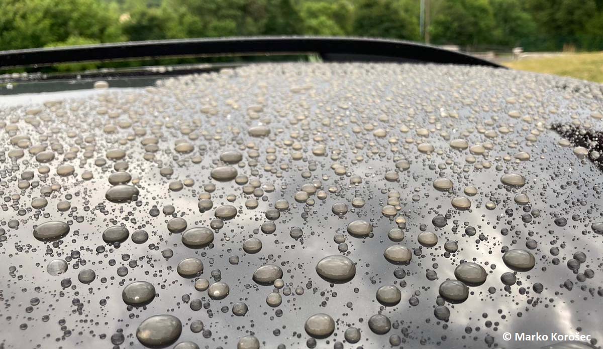
If such a dust cloud event occurs and coincides with a frontal system and therefore rain, the dust will be brought to the ground. Then, we can observe the dust deposited on objects and we find an (often thick) layer of dust, dusty drops on the car, or similar.
A formation of a massive dust cloud is often related to the thunderstorm activity near or over the desert areas in northern Africa, while strong winds could blow the dust particles far away. Depending on the intensity if the jet stream, huge dust cloud could form and travel long distances, also across the Atlantic Ocean.
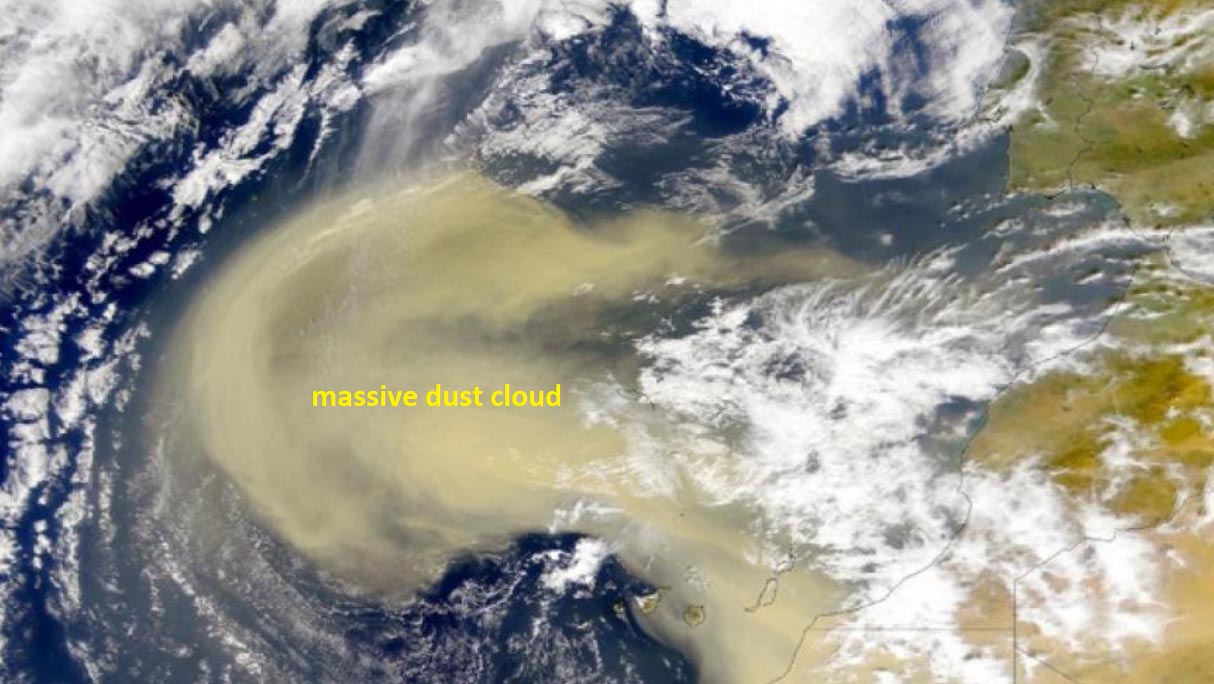
Above: A massive dust cloud (storm) is blowing off the African desert and spreads across the eastern Atlantic Ocean. Credits: NASA
Besides gaseous pollutants, the atmosphere is also polluted by different particles. These particles, either in suspension, fluid or solid-state, have a divergent composition and size and are sometimes called aerosols.
Aerosols are often cataloged as floating dust but are best known as PM particles. PM is an abbreviation for Particulate Matter. These are typically categorized based on their aerodynamic diameter.
The aerodynamic diameter of a dust particle is the diameter of a sphere-shaped particle that shows the same behavior in the atmosphere as a dust particle (which does not necessarily have a sphere shape). In the framework of air quality problems, particulate matter is the most important.

Particulate matter such as PM10, PM2, or PM1 is defined as the fraction of particles with an aerodynamic diameter smaller than respectively 10, 2.5, or 1. To better imagine how small these particles are, 1 µm is 1 millionth of a meter or 1 thousandth of a millimeter.
Indeed, very small particles. And if we compare those with the average diameter of human hair which equals 50-70 µm, we can see dust cloud particles are 5-50x smaller.
SAHARAN DUST CLOUD SPREADING ACROSS THE MEDITERRANEAN REGION, TURNING INTO THE NORTHERN BALKANS
The general weather pattern has begun its change this past weekend as the upper-level ridge is strengthening with a rising surface pressure over the eastern and southern parts of continental Europe. At the same time, a deepening trough is establishing over the North Atlantic and western Europe, with a southwesterly jet stream in between the two large-scale features.
Yesterday, Sunday, July 25th, these changes in the mid/upper-level flow have brought our attention to the ongoing activity over north Africa, precisely Algerian deserts. The NASA MODIS satellite image indicates the initial start of the Saharan dust cloud advection from northern Algeria towards the northeast, into the southwestern and western Mediterranean region.
A thick dust cloud is now gradually spreading northeast and has already reached the northern Mediterranean and the northern Balkan peninsula. With dust particles deposits reported from northern Italy, Croatia, and Slovenia this Monday morning.

We can easily see where the thickest layers of dust cloud were observed on Sunday afternoon, while the favorable strong jet stream (marked with yellow arrow) will help to additionally push the dust farther northeast towards eastern Europe and also towards Scandinavia Monday through Wednesday.
Unstable, the mostly Atlantic maritime air mass, is also well visible spread across western Europe, with scattered to widespread convective activity under the main core of the upper trough. A diffuse cold front is seen over the Alps, moving east.
Note: The cloud pattern extending from northern Algeria towards Italy and the Adriatic sea is the Saharan elevated mixed layer (EML) that has been pushed with the persistent jet stream.
DUST CLOUD SPREADS TOWARDS EASTERN EUROPE AND SCANDINAVIA THIS WEEK
South-southwesterly winds have developed between the European continental ridge and the North Atlantic depression which will be persisting for a few more days. This will help the Saharan dust cloud to advect farther northeast, reaching eastern Europe, and also southern Scandinavia.
Here is the 250 mbar (jet stream) wind chart, showing strong winds between the two large-scale features, the trough to its north and the blocking High to its southeast. This is a rather typical setup across southern Europe when a cloud of Saharan dust gets its way towards continental Europe.

The highest concentrations of the Saharan dust cloud are first spread across the western and central parts of the Mediterranean this Monday and will continue northeast tonight. We can also see some dust particles are also spread farther east and north across Hungary, Romania into Poland, and also northeast Germany, southern Sweden, and Denmark.
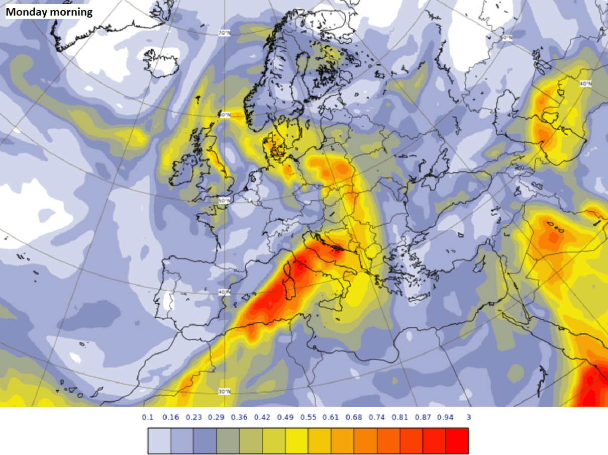
Part of the huge and dense dust cloud that is now accumulated over the Mediterranean will advect into the northern Balkan peninsula Monday night, with a high concentration of the particles. Those will be accumulating on the ground as rainfall is forecast.
With all the significant thickness of dust cloud remaining over the central Mediterranean, we can expect more of it will spread northeast through tonight and Tuesday as well. The thickest layer of the dust cloud over Hungary, Romania, and Ukraine will happen through Tuesday night.

The Copernicus Atmosphere Monitoring Service (CAMS), warns that high concentrations of dust can have health impacts on the respiratory systems of all people in the affected regions and add to air pollution from local sources.
Given the number of dust particles being quite significant again within this dust cloud, it could lead to skies turning orange with limited visibility and dust deposits on the cars and other objects exposed outside.
Towards the weekend, some changes in the weather pattern over Europe will gradually vanish the dust concentrations over the northern and eastern parts. While another more significant dust cloud is likely to develop over the Mediterranean on Friday.
Thanks to the repeating pattern a strong upper ridge remains over the Balkan peninsula while troughs also continue over western Europe. The strong upper-level winds in between the two will keep being favorable for an advection from the southwesterly directions.

Further west, over the Iberian peninsula, or western Europe, the general flow from the Atlantic serves clearer air, without any dust particles that will only remain farther east.
Starting this Tuesday (tomorrow), the upper High over the southern Mediterranean will be gradually expanding and strengthening towards the Balkan peninsula, developing an intense heatwave. Temperatures will climb above 40 °C in many areas.
SIGNIFICANT HEATWAVE DEVELOPS ACROSS THE MEDITERRANEAN AND THE BALKAN PENINSULA
Through the remainder of July, a favorable situation develops over the Balkan peninsula, a strong upper-level ridge will develop and persist for days. Leading to a significant heatwave, likely the most intense of summer 2021 is forecast.
A classic dipole pattern should, besides the Saharan dust advection, allow very warm air mass to push into the peninsula, with relatively very dry conditions. Stable weather is expected.
While unsettled conditions will remain further west under the Atlantic low, as well as in between where frontal boundaries will serve as a focus for thunderstorms on daily basis.

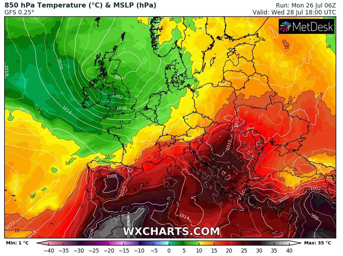
Temperatures will very likely reach much above-average average from the Mediterranean into the Balkan peninsula, as well as parts of western Turkey and eastern Europe. Temperatures between 22 and 18 °C at the 850 mbar level are expected.
South-central Italy and the south-central Balkan peninsula should experience the worst heat in the lowest levels of the atmosphere, thanks to the core of the heatwave sitting over the peninsula for days.
Daytime temperatures should push close to and above 40 °C marks in many areas, especially in the valleys and plains where the air mass usually warms the most. Should not exclude parts of Serbia, North Macedonia, Romania, Bulgaria, Albania, and Greece to see peak afternoon temperatures between 40 and 45 °C in some of the days until the weekend.

Further pattern trends also hint at the extension of the significant heatwave also into the first week of August. Earlier, heatwave might eventually also expand further north and east towards the end of this week.
We will have more updates on the development of this intense heatwave soon – stay tuned!
Similar events in the past:
Huge Saharan dust load over south-central Europe, also towards the UK and Ireland (May 14th, 2020)
***The images used in this article were provided by Windy, PivotalWeather, and Wxcharts.