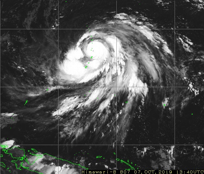
Super Typhoon Hagibis keeps strengthening, now at equivalent-CAT5 hurricane strength!
Latest analysis by the Joint Typhoon Warning Center (JTWC) in the 12h UTC update indicate Hagibis has reached 259 km/h (140 kt) peak sustained winds, an equivalent-CAT5 system! Peak wind gusts are now at 315 km/h!
Hagibis underwent explosive strengthening yesterday and earlier today, from a tropical storm to equivalent-CAT4 super typhoon – a 145 km/h increase in peak sustained winds – in only 18 hours!
13:40 UTC short wave IR image of Super Typhoon Hagibis just east of the Marianas Islands. Note the extremely tight, small eye! Image: Himawari-8 / Japan Meteorological Agency (JMA).
It is expected to further strengthen to 278 km/h peak sustained winds, per latest JTWC warning. The extremely tight eye will likely destabilize some time soon and undergo an eyewall replacement cycle. When it happens, the collapsing tight eye will be replaced by a larger eye and a (transient) drop in peak sustained wind speed.
#Hagibis has intensified by 90 mph in 18 hours – from a tropical storm to a #supertyphoon. This is the most intensification by a tropical cyclone in the western North Pacific in 18 hours since Yates in 1996 also intensified by 90 mph in 18 hours. pic.twitter.com/OspbbYwr4D
— Philip Klotzbach (@philklotzbach) October 7, 2019
The satellite appearance of typhoon #Hagibis is phenomenal and will likely improve after an expected EWRC which will likely occur within 24 hours. Based on satellite alone I wouldn’t be shocked if this thing was at 150-155 kts in the next advisory. pic.twitter.com/AhM6QHeffK
— Berry Outlooks (@BerryTracker) October 7, 2019
Wow, really insane vertical structure to detect such high dBz from so far away! Might be 2-3 mile diameter ‘eye’! Super intense #Hagibis pic.twitter.com/Qb2jZLGHhx
— Simon Brewer (@SimonStormRider) October 7, 2019
Latest satellite and radar imagery indicates the tight, pinhole eye is only about ~6-10 km across!
Well this is something else. It is dubious to measure #Hagibis‘s eye size with radar bins this wide, but it’s darn small. This is at a beam height of ~29,000 feet, which means the eye is likely a touch smaller at its base, since eyewalls slope outward with height. pic.twitter.com/WBBtrvuoLp
— Levi Cowan (@TropicalTidbits) October 7, 2019
The exceptionally small, tight eye is reminiscent of extreme hurricane Patricia in 2015 – the record holder for the strongest sustained winds for a tropical cyclone, at 345 km/h (215 mph). The extremely tight eye of Hagibis suggests peak sustained winds may be higher than currently estimated.
Super typhoon Hagibis tracked over the northern Marianas and is now moving towards southern Japan.
Cover image: Himawari-8 / Japan Meteorological Agency (JMA).
Stay tuned for further updates!
