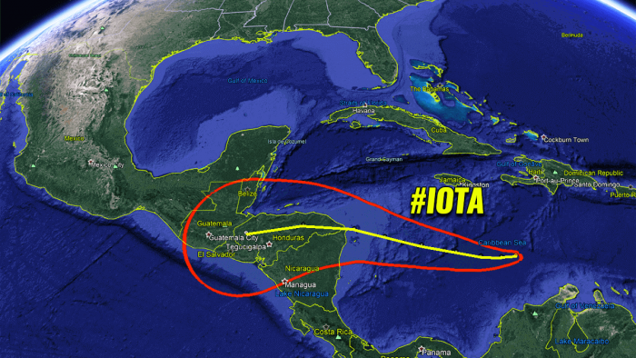
The Atlantic Hurricane season 2020 is on roll. Yet another Tropical Storm – Iota – has formed over the Caribbean today (Friday, Nov 13th). Iota is a record-breaking 30th named storm of the season. Model guidance suggests that it will rapidly intensify into a major hurricane prior to landfall in Central America on Monday. Severe impact with destructive flooding and life-threatening landslides in Nicaragua and Honduras is likely.
Hurricane Warning for Nicaragua and Honduras ahead of an explosively intensifying hurricane Iota, now heads for another record in this historic hurricane season
A Tropical Storm Iota is expected to rapidly intensify to a major hurricane while it approaches the coast of Central America. There is a risk of dangerous wind, storm surge, and rainfall impacts across portions of Nicaragua and Honduras beginning Sunday night.
Hurricane Watches will soon be issued for a portion of this area tonight, while a hurricane warning issuance will follow over the weekend.
Over the Atlantic basin, there are currently two named storms simultaneously – Tropical Storm Theta and now a Tropical Storm Iota.
This is the latest in the calendar year that the Atlantic hurricane season has had two named storms simultaneously since 1887, dr. Philip Klotzbach tweeted.
Iota is the 30th named storm of the 2020 hurricane season and is rising the count of the already extremely-active and record-breaking season. This is the first time on record that Atlantic hurricane season would go this deep into the Greek alphabet list for named storms.
Iota is the 9th named storm from the Greek Alphabet list and also the 31st tropical depression forming in 2020. It is now tied with the previous record from the 2005 season.
Through Wednesday morning, heavy rainfall from Tropical Storm Iota (or likely major Hurricane Iota) may lead to life-threatening flash flooding and river flooding across portions of Haiti, Jamaica, and Central America.
Flooding and landslides from heavy rainfall could be significant across Central America given recovery efforts underway after Hurricane Eta.
Central American countries Nicaragua, Honduras, and Guatemala are suffering a significant humanitarian crisis after the destructive impact of a high-end Category 4 hurricane Eta last week. Eta has brought a high death toll due to the remarkable amount of rainfall, which leads to deadly flooding and landslides.
And what appears likely on the model guidance regarding the track of Hurricane Iota, we may be facing another deadly disaster over central America. There is a very high concern of another catastrophic flooding and life-threatening event developing into Nicaragua, Honduras, and Guatemala next week.
As Iota is forecast to become a major hurricane (Category 3 or greater) prior to its landfall in Central America on Monday, this would be 2nd major hurricane to form this November (remember, major hurricane Eta was the other one).
If this occurs, it will set another remarkable record for the 2020 Atlantic hurricane season – there are no seasons on record that have had two major hurricane formations in the month of November!
DEEP TROPICAL WAVE
Deep convection associated with the area of low pressure over the central Caribbean Sea (about 300 miles south of Jamaica) has increased and become more concentrated since Thursday.
Visible satellite imagery shows that the circulation has also become better defined, with a westerly component seen in the low-cloud motion near the southwestern edge of the primary convective mass.
Banding features over the eastern and southeastern portions of the cyclone’s circulation have increased since Friday morning, and the overall organization of the system continues to quickly improve.
Based on the continued increase in organization, and Dvorak T-numbers of T2.5 from both TAFB and SAB, the initial intensity is raised to 35 knots (40 mph).
The environmental conditions of very low vertical wind shear, extremely warm sea surface temperatures and a moist atmosphere are very favorable for intensification over the next few days. Given the current broad and sprawling structure of the system, strengthening of Tropical Storm Iota may begin as gradual today.
MJO WAVE AND HOT CARIBBEAN SEA WATERS REMAINS IN PLACE
The sea surface temperatures remain very warm in the Western Atlantic, and extremely warm over the Caribbean region with around 30 °C (86 °F) across the western portions of the Caribbean Sea.
This is a very worrying signal as sea waters remain much higher than the long-term average. So Tropical Storm Iota has the most important ingredient ready, therefore strongly supporting the rapid or even explosive development of thunderstorms in the coming days.
Graphics below are provided by Windy.com.
The majority of the North Atlantic, tropical Atlantic, and the Caribbean are still well-above average, about 1-2 °C warmer, even more across the Northwest Atlantic.
Waters remain warm, much above the long-term average across the whole Gulf of Mexico, around Florida, the Bahamas, and along the East Coast of the United States.
And to top this, there is still a pronounced MJO wave underway over the tropical Atlantic, ongoing since the end of September.
The Madden-Julian Oscillation (MJO) is the largest and most dominant source of short-term tropical variability, it is an eastward-moving wave of thunderstorms, clouds, rain, winds, and pressure. It circles the entire planet on the equator in about 30 to 60 days.
As we can see from the graphics below, it is a very obvious feature this week (first chart and marked with a red circle), with blue color over the Atlantic basin. On the week 1 forecast (second chart) the MJO wave will begin weakening but still not completely vanished.
So this means that it will continue lowering the pressure and providing a strong boost to thunderstorm activity in the tropical Atlantic towards through mid to end of November.
The above graphics, provided by Michael J. Ventrice, Ph.D. represent an MJO wave with filtered VP200* anomalies for the current state and for the week 1 forecast.
Cold colors are representative of a more favorable state over the Atlantic for tropical cyclogenesis while warm colors represent a less favorable state for tropical cyclogenesis.
*VP200 – means a Velocity Potential (VP). It is an indicator of the large scale divergent flow, so at upper levels in the tropics. The negative VP anomalies (shaded blue in the diagram) are closely tied to the divergent outflow from enhanced convective regions.
IOTA IS EXPECTED TO REACH MAJOR HURRICANE STRENGTH
As we have seen above, extremely warm Caribbean Sea waters will allow significant strengthening of Tropical Storm Iota over the weekend. Iota is expected to become a (major) hurricane. Once an inner core organizes, a rapid strengthening appears very likely.
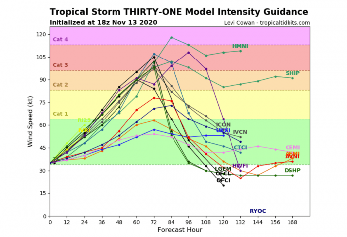
Some weather models are hinting around 70 knots (80 mph) increase in wind speed over the next 72 hours. This would bring Iota to a major hurricane (Category 3 or greater) by Monday.
The NHC forecast is also, based on these model simulations, calling for significant strengthening and the system could approach the coast of Central America as a major hurricane early next week (likely on Monday).
On the forecast track, the cyclone is expected to approach the coast of Central America in 60-72 hours. The track guidance is in good agreement through the first couple of days, but there is increasing cross-track spread after that time.
Indeed, until the system completely matures, it is hard to forecast where exactly it will be tracking. For now, the highest chances for the system’s landfall are along northeastern Nicaragua and eastern Honduras.
However, some of the track model guidance keeps the system just off the coast, traveling to the north on Honduras. If this scenario will develop, then Iota will be even stronger as it would stay over very warm waters after missing the interaction with the land of Central America.
A Tropical Storm Iota is currently moving west-southwestward at about 5 knots forward speed. A strong mid-level ridge that is centered over Florida and the western Atlantic should steer the cyclone west-southwestward during the next 24 hours.
After that time, the ridge is forecast to begin sliding eastward, and westward to the west-northwestward motion of Tropical Storm/Hurricane Iota should begin.
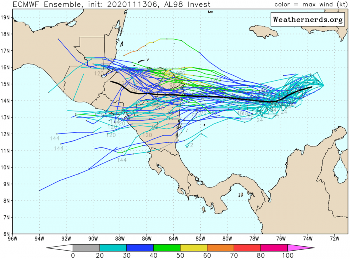
The majority of the models (attached below is the comparison on ECMWF and GEFS models) hint a very severe impact on Central America.
While we can see above, that the ECMWF model tracks are mainly pointing to the landfall in Nicaragua/Honduras, the chart below is based on the GEFS model.
This model is also hinting a possibility that Iota would eventually miss the landfall in Central America and continue west-northwest just north of Honduras. Such a scenario would lead to additional strengthening and bring Iota towards Belize or even Yucatan. However, these chances are very low for now.
DEADLY FLOODING AND LANDSLIDES THREAT IS LIKELY AGAIN
Interests in Nicaragua, Honduras, and Guatemala should monitor the progress of Iota very closely this weekend. The European model, ECMWF, is simulating an extremely concerning amount of rainfall over the next 10 days.
Even close to 30 inches (750 mm) in total in parts of western Honduras and eastern Guatemala.
Again there is a HIGH RISK for life-threatening, deadly flooding and landslides. Just a week after the *same* region was strike with deadly flooding and landslides.
A lot of rainfall is also forecast across the whole of northern Honduras, as Hurricane Iota is likely to track very near or over this region. Northern Guatemala and northern Nicaragua should also receive a lot of rain, potentially 10-15 inches (250-400 mm) will be possible.
This would worsen the ongoing flooding disaster in the Central American region.
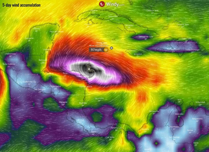
Based on the wind forecast, we can see that Iota will be gaining strength and develop violent hurricane-force winds in the coming days. Attached is the GFS model guidance for peak wind gusts along the system’s track.
GFS’ main model run actually keeps tracking Iota just to the north of Honduras coast and not making the landfall. So the system keeps getting stronger.
But as we have seen on the ensemble tracks from the GEFS model above, these chances remain quite low at this time. But Iota’s behavior has to be closely monitored this weekend.
2020 ATLANTIC HURRICANE SEASON NOW GOES FOR 30+ NAMED STORMS
With the currently ongoing Tropical Storm Theta and now a Tropical Storm Iota, we have reached the 30th named storm of the 2020 Atlantic hurricane season.
Iota, therefore, is the ninth (9th) named storm from the Greek alphabet list. So we are now well above the previous record of 6 named storms from this list, set in 2005.
The 2020 Atlantic hurricane season continues into uncharted territory and breaking record by record further.
The hurricane season 2020 is now the most active on record, breaking the previous record hurricane season 2005. The 2005 season had three (3) named storm formations in November, while 2020 is currently also counting three storm formations (Eta formed on Nov 1st, Theta on Nov 8th and Iota formed on Nov 13th).
With a still high potential for a few more tropical depressions or storms forming through November, we might be reaching halfway through the Greek Alphabet names.
There seems to be a fairly high chance that the well-above-average western Atlantic and Caribbean region sea temperatures would be favorable for tropical storm formation even in December this year. And season might be aiming towards Nu or Xi storm names at the end.
But let us go step by step. We are now are the 30th named storm of the 2020 hurricane season. The potential remains high that additional storms could form in the next two weeks. Global models are definitely trending this way.
Nevertheless, stay tuned for additional updates soon – the next update is scheduled when Iota reaches (major) hurricane strength.
Don’t miss a chance for a nice gift for your friends, family or someone special… Weather calendar could be the perfect gift for them – see below:


