Hurricane Florence has lost some of its strength and is now a solid strong CAT 2 hurricane, but it remains a very large storm. Due to significant interaction with some shear to its south, Florence outflow was disturbed and caused it to weaken further since last night. As landfall is still 18 hours away, it could re-strengthen back to CAT 3 given the more favorable conditions along its path towards North Carolina today.
Morning satellite reveals still an impressive structure and ideal outflow ventilation on the northern side of Florence, while wind shear effect is evident on its southern side combined with the dry intrusion. However, very intense convection with colder cloud tops has lately appeared along the eyewall again.
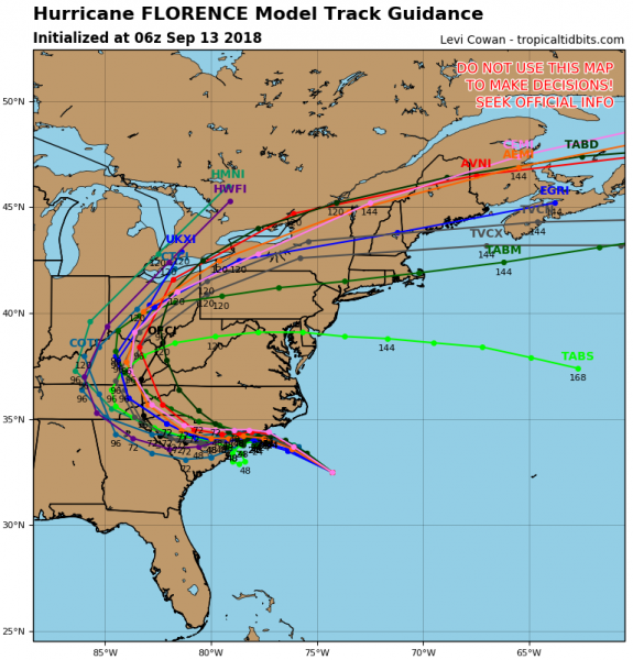
Latest model track guidance remains very similar to the previous update:; landfall is expected in North Carolina this evening. Florence then slows down and slides towards WSW for 48 hours into South Carolina where it finally starts moving north and weakens into a post-tropical storm/depression and accelerates towards the northeast.
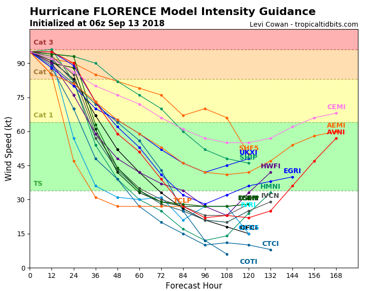
Model intensity guidance suggests Florence will remain a strong CAT 2 hurricane until landfall (although there are still some chances it acquires CAT 3 strength in the next 12 hours – awaiting NOAA Hurricane Hunters analysis this afternoon) and then rapidly weakens its wind threat, while intense rainfall and flooding continues.
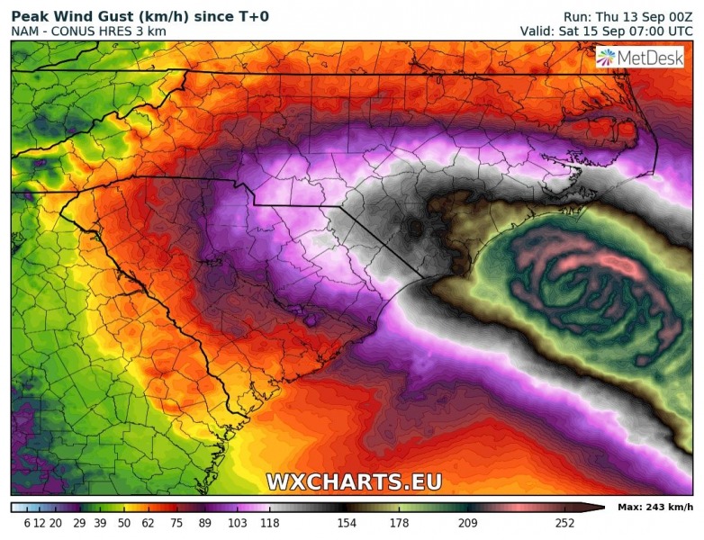
The simulated swath of the strongest winds associated with hurricane movement from Atlantic into North Carolina tonight – coastal areas could be exposed to CAT 2/3 winds and gusts, locally exceeding 200 km/h!
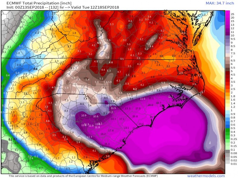
Various models (attached are NAM and ECMWF runs) confirm a truly extreme amount of rainfall likely to occur across the coastal areas of North and South Carolina. It remains possible there will be 30-40 inches of total rainfall (possibly even more) in some places – that is 750-1000 mm of rainfall within 48-72 hours. Combine this with the expected major storm surge, and the amount of flooding will be devastating.
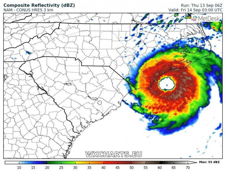
NAM model simulated reflectivity of Florence: landfall is expected on the SW coast of North Carolina in the late late evening (close to Sept 14th, 06 UTC). Florence will then move very slowly towards WSW into South Carolina and maintain an extreme rainfall and flooding threat.
Here is the latest NHC forecast discussion:
Hurricane Florence Discussion Number 56
NWS National Hurricane Center Miami FL AL062018
500 AM EDT Thu Sep 13 2018
The satellite presentation of Florence has changed little overnight with the eye waxing and waning in infrared imagery. The eye has moved into NWS radar range and can be seen in radar data from Morehead City and Wilmington NWS 88-D imagery. An 0616 UTC AMSR2 microwave overpass indicated that the convection over the southern and southeastern portions of the storm is still disrupted, and that the eyewall was open to the southeast. An Air Force Hurricane Hunter aircraft also reported that the eyewall was not fully intact on its last pass through the storm just after that time. The Air Force plane measured a peak 700-mb flight level wind of 102 kt and peak SFMR winds of 85 kt during the mission. These data suggest that the intensity may be slightly lower, but the initial intensity has been maintained at 95 kt, since the plane may not have sampled the strongest winds. Another Air Force plane will be in Florence shortly, and should provide a better assessment of the intensity of the hurricane. As mentioned in the previous discussion, it appears that some southern shear has caused the degradation of the inner core. The global models suggest that this shear will relax today while Florence moves over warm waters, however, given the current storm structure, little overall change in strength is anticipated as Florence approaches the coast. Gradual weakening should occur as the hurricane interacts with land in 24-36 h, with a faster rate of weakening predicted once Florence moves farther inland.
Florence is moving northwestward or 315 degrees at 13 kt. A developing mid-level ridge over the north-central United States should cause the forward speed of the hurricane to decrease today.
As the steering currents collapse tonight and Friday, Florence is forecast to drift westward or west-southwestward and continue that slow motion into the weekend. The global models predict that the ridge will slide eastward over the weekend, which should allow Florence to turn northwestward and northward by the end of the forecast period. Although there is still some spread in the guidance by 48 hours, with the GFS along the northern side of the guidance envelope, and the ECWMF along the southern edge, the various consensus aids have moved little. As a result, the new NHC forecast track is very similar to the previous advisory.
Aircraft and satellite wind data show that Florence is a large
hurricane. Life-threatening storm surge, heavy rainfall, and
damaging wind will cover a large area regardless of exactly where
the center of Florence moves.
Key Messages:
1. A life-threatening storm surge is now highly likely along portions of the coastlines of South Carolina and North Carolina, and a Storm Surge Warning is in effect for a portion of this area. All interests in these areas should complete preparations and follow any advice given by local officials.
2. Life-threatening, catastrophic flash flooding and prolonged significant river flooding are likely over portions of the Carolinas and the southern and central Appalachians late this week into early next week, as Florence is expected to slow down as it approaches thecoast and moves inland.
3. Damaging hurricane-force winds are likely along portions of the coasts of South Carolina and North Carolina, and a Hurricane Warning is in effect. Strong winds could also spread inland into portions of the Carolinas.
4. Large swells affecting Bermuda, portions of the U.S. East Coast, and the northwestern and central Bahamas will continue this week, resulting in life-threatening surf and rip currents.
FORECAST POSITIONS AND MAX WINDS
INIT 13/0900Z 32.8N 74.7W 95 KT 110 MPH
12H 13/1800Z 33.7N 76.1W 95 KT 110 MPH
24H 14/0600Z 34.2N 77.4W 90 KT 105 MPH
36H 14/1800Z 34.3N 78.4W 70 KT 80 MPH…INLAND
48H 15/0600Z 34.1N 79.2W 50 KT 60 MPH…INLAND
72H 16/0600Z 33.9N 81.2W 30 KT 35 MPH…INLAND
96H 17/0600Z 35.4N 83.3W 25 KT 30 MPH…INLAND
120H 18/0600Z 39.5N 81.0W 20 KT 25 MPH…POST-TROP/REMNT LOW
Forecaster Brown
We will have updates later this afternoon when data from the NOAA flights will become available – stay tuned!

