https://www.facebook.com/severeweatherEU/videos/1871537169736042/
Weather outlook for Europe for the next 10 days: gradual pattern change. Late summer returns in southwestern Europe. Unsettled and cool in other areas.
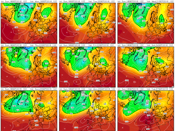
The strong omega block over the northern half of Europe will persist until about September 25, with cyclones centered over north Atlantic and NW Europe, with a ridge extending across W-CNTRL Europe high into Scandinavia. The large cutoff low over CNTRL Mediterranean – Balkans gradually weakens and a ridge slowly establishes over the Iberian peninsula and France.
9-day GFS outlook panel. Map: Wetterzentrale.de.
Central Europe (Germany, Switzerland, Austria, Czech Republic, Slovakia, BeNeLux): weather remains cool and unsettled. Daytime highs up to 18-21 °C persist over N Germany over the next three days with night lows going all the way down to 0 °C in the extreme south. A front passes on Thursday & Friday (Sept 22-23). Only marginal instability is expected, in the 100-400 J/kg MLCAPE range, so expect some lightning and thunder, but mostly rain showers. Another front passes on Sunday-Monday (Sept 25-26). Afterwards a cutoff low establishes over Denmark/N Germany, bringing more rain and unstable weather with temperatures in the 5 – 19 °C range.
Mediterranean: the western part of the Mediterranean (Balearic Islands, Corsica, Sardinia) sees the weather stabilizing, with daytime highs gradually climbing from 20-22 °C on September 19 towards 27-28 °C by September 26. Clear skies with occasional high clouds there.
Eastern Mediterranean and southeastern Europe (Italy, Malta, Slovenia, Croatia, Hungary, Bosnia and Herzegovina, Serbia, Albania, FYR Macedonia, Greece, Romania, Bulgaria): the large area of low pressure with multiple embeded lows slowly expands and weakens during the period. Widespread showers and thunderstorms in the region over the next 3-4 days, daytime highs around 25 °C close to the coast of the Mediterranean (including the Adtiatic, Ionian and Aegean sea). A strong cold front advances over the Alps into the Balkans on September 24-25. Limited instability available ahead of the front, limited thunderstorm potential. The front advances towards the SE Balkans and gradually weakens. The exact pattern is currently still fairly uncertain, we will be posting updates as it evolves.
Eastern Europe (Poland, Belarus, Baltic States, Ukraine, W Russia, Moldova): cooler weather will persist over the entire region as a cutoff low establishes there. Rain showers and thunderstorms will occur over most of the region, particularly towards the end of the period. Daytime highs in the 15-20 °C range over the entire region.
Scandinavia: the strong ridge over Scandinavia brings stable and relatively warm weather with daytime highs in the 14-17 °C range over the entire region during the first several days. The weather destabilizes gradually after September 24, with daytime highs dropping towards 6-8 °C and widespread and fairly intense rainfall.
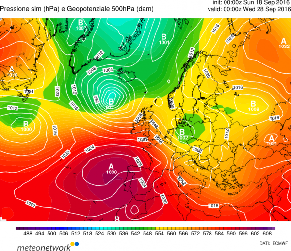
ECMFW model guidance for Wednesday, September 28. Map: MNW.
Western Europe (Portugal, Spain, France): a strong ridge gradually establishes over the Iberian peninsula and extends into France. Warm late summer weather for the entire region, daytime highs increase from 28 °C to 33 °C in SE Spain and 20 °C to 27 °C in central France. Enjoy the late summer!
British Isles and Ireland: mostly cool and unsettled weather, cloudy with some rain showers, in particular during the second half of the period (Sept 23-28). Daytime highs up to 20 °C in the southern half of the Isles, but only up to 15 °C further north in Scotland and Ireland.
We will be monitoring the weather patterns and individual systems on a daily basis. Stay tuned for updates!

