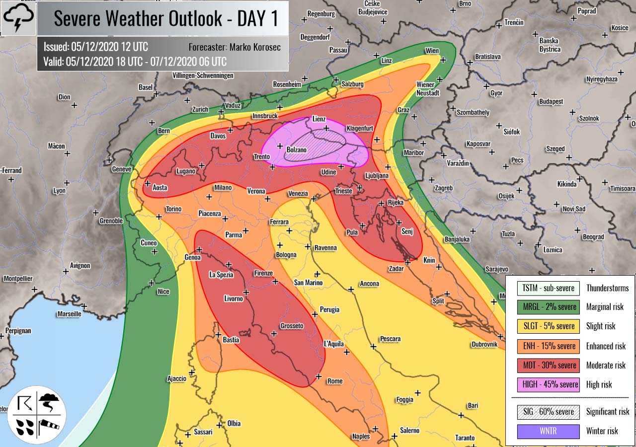
Severe weather outlook – forecast across Europe. This forecast features areas of organized severe weather with risk levels and severe weather threats across the European continent.
SEVERE WEATHER OUTLOOK – DAY 1
Valid: 05/12/2020 18 UTC – 07/12/2020 06 UTC
Issued by: Severe Weather Europe
Forecaster: Marko Korošec
SUMMARY
A ***particularly dangerous situation*** is expected to develop across the Alps on Sunday, December 6th. An extreme amount of rain and snow is expected, with local rainfall sums reaching 500+ mm. More than 300 cm of fresh snow seems increasingly likely above 1800 m elevation over these areas!
A combination of excessive rainfall, snow melting, and snowfall at higher altitudes could lead to damaging flooding and avalanches in the region!
Overview of the risk areas across Europe
SYNOPTIC OVERVIEW
A very deep and intense upper trough/low has established across western and southwestern Europe while a persistent upper-level ridge is placed across western Russia and eastern Europe. In between these two large scale features, a powerful southerly jet stream is advecting high moisture towards north. And significantly warmer air mass is being pumped from the Mediterranean into Central Europe and the Alps. While at the surface, a deep secondary low is emerging over Italy.
FORECAST DISCUSSION
+++ the Alps, Italy, Austria and Slovenia +++
A SIG RISK (significant) and WNTR RISK (winter) have been been issued for parts of the northeast Italy into southern Austria with threat for extreme amount of rain and snow. Rainfall sums could reach more than 500 mm over the period of 36 hours between Saturday afternoon and Sunday night, while locally more than 300 cm of fresh snow could accumulate above 1800 m elevations over the same period.
A HIGH/MDT risks has been issued for the areas surrounding the SIG RISK, including western Slovenia, Croatia, and central Italy along the Apennines where excessive rainfall will push rainfall sums between 100 and 200 mm over the 36-hour period.
There is a VERY HIGH potential for damaging flooding and avalanche risk across the areas highlighted within SIG & HIGH risk levels.
Various high-resolution weather models are hinting that 400-600 mm (15-25 inches) of accumulated precipitation will be possible across the northeast Italian and southern Austrian mountainous terrain from Saturday afternoon until Sunday evening.
Indeed as very heavy snow over the higher elevations, therefore even more than 300 cm (3 meters or 10 feet) of fresh snow could accumulate until Sunday night.
There is potentially a very dangerous outcome from these significant amounts of rain and snow over this part of the Alps. The forecasted amounts of rain and snow are so extreme in a relatively short period of time, that a *SIG/WNTR RISK* for flooding/avalanches is expected on Sunday.
Conditions are rapidly worsening over the northern Mediterranean and the Alps, as both the warm advection from the Mediterranean and the wind field are increasing. In other words, this means strongly enhanced orographic rainfall or snowfall for the northern Mediterranean region.
The majority of these rain and snow amounts will accumulate from Saturday afternoon until Sunday evening, as most of the precipitation will be associated with the deep secondary surface low over northern Italy over the weekend. So the amount of rain will be roughly a relatively short, 36-hour event!
Such an amount of rain could become a serious flooding threat for the lowlands along the slopes, also depending on how high the snowfall will be occurring. The higher it occurs, the more rain could accumulate as this means the warm advection will be stronger and push more moisture into the Alps.
Although the amounts of rain outside the SIG/HIGH risk areas will be less extreme, it could still lead to some local flooding.
ENH/SLGT risks have been issued for parts of the Mediterranean with threat for severe storms with torrential rainfall and severe winds threat.
Follow & report severe weather events on our Facebook page:
Severe Weather Europe Facebook page
Understanding Severe Weather Outlook
Severe Weather Outlook features areas of organized severe weather with risk levels and severe weather threats. Risk levels are divided into seven categories:
TSTM – Thunderstorms
MRGL – Marginal risk
SLGT – Slight risk
ENH – Enhanced risk
MDT – Moderate risk
HIGH – High risk
SIG – Significant risk
WNTR – Winter risk
Risk categories stand for the coverage and intensity of organized severe weather. Those could include supercells, squall lines, mesoscale convective systems, wind storms, flooding, snowstorms, or ice storms.
Severe weather threats include:
- large hail (of at least 2 cm in diameter)
- Tornadoes (including waterspouts)
- Wind gusts (convective or non-convective) above 25 m/s (or above 90 km/h)
- Torrential convective precipitation / Flash floods
- Excessive rainfall (100 mm within 12 hours) / snowfall (50 cm within 12 hours)
Extremely severe weather threats include:
- Large hail (of at least 5 cm in diameter)
- Tornadoes of F2 intensity or stronger
- Wind gusts (convective or non-convective) above 33 m/s (or above 119 km/h) or 12 Bft
- Torrential convective precipitation / Flash floods
- Excessive rainfall (150 mm within 12 hours or above ) / snowfall (above 100 cm within 24 hours)
Categories in the forecast represent the chance of severe weather occurring within a 40 km radius from a location. The used level is based on the conversion table of probabilistic risk into the outlook categories. A threat level is upgraded into a higher category if probabilities meet the threshold criteria for the specific threat (e.g. tornado, wind, hail, or rainfall threat).
Each individual threat area includes a detailed forecast map and discussion on the potential of severe weather threats.
Read more: Explanations for abbreviations (TSTM, SLGT, ENH, etc.)

