An extremely rapid intensification of an extratropical storm over the North Pacific is still underway this Saturday, now approaching the Aleutian Islands of Alaska and moving further northeast towards the Pacific Northwest of Canada and the United States. The bomb cyclone has developed very violent hurricane-force winds and massive waves across the North Pacific, gradually spreading towards the North American Pacific Northwest coast.
The system has been well-predicted by weather models and a bombogenesis* process has been underway over the Northwest Pacific ocean since early Friday, extremely rapid intensification continues also on Saturday.
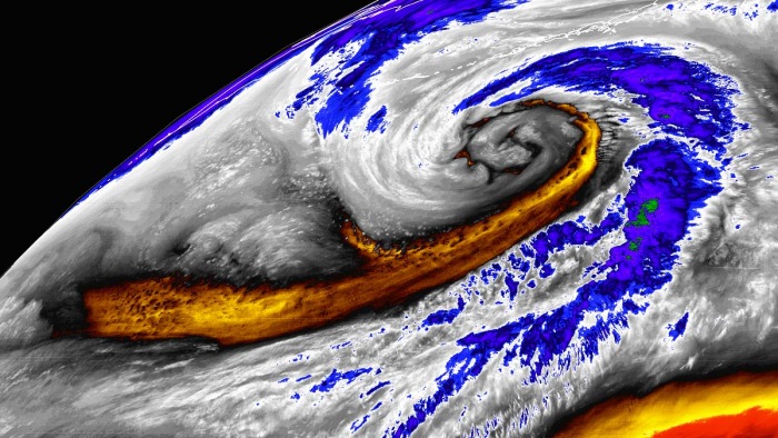
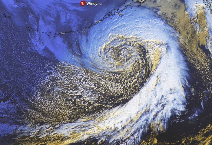
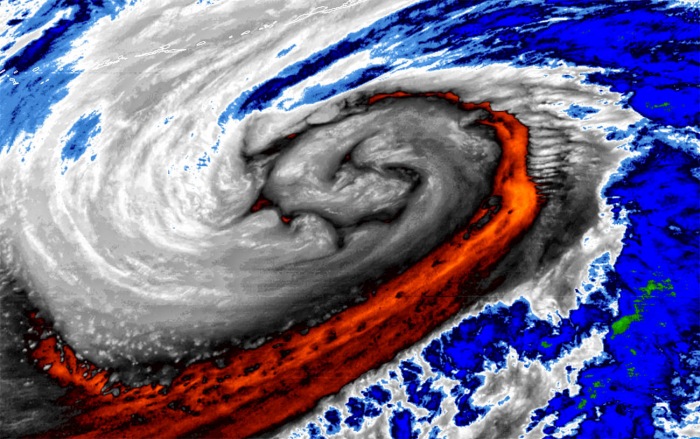
A very impressive, textbook appearance of the extratropical storm is seen by the satellite imagery!
This extratropical low is classified as a bomb cyclone, a system that intensifies very rapidly. Bomb cyclones form when explosive cyclogenesis (or bombogenesis) with the rapid deepening of its barometric pressure occurs.
Generally, a pressure change in its center is of at least 24 millibars within 24 hours. These are the criteria that the system needs to meet to be classified as a bomb cyclone.
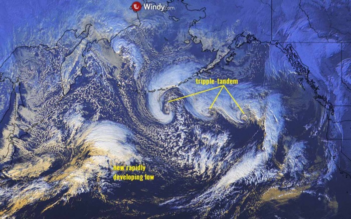
The system has literally exploded just a day after a remarkable sight was seen over the Pacific, a triple-tandem of cyclones on Thursday.
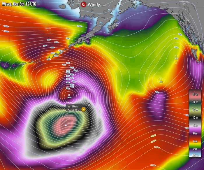
An impressive, rapid intensification took a faster rate on Friday and is now near its peak on Saturday. The very large size of this system is expected to generate violent hurricane-force winds and massive waves over the North Pacific. Models were simulating more than 15-meter waves are developing through Friday night into Saturday and Sunday.
Attached below is the video animation of the storm from the start of its rapid intensification from Friday morning until Saturday morning. It is introducing massive waves to the south of a deep core of this extratropical storm:
*Bombogenesis is a popular term that describes a mid-latitude cyclone that rapidly intensifies.
Bombogenesis, a popular term used by meteorologists, occurs when a midlatitude cyclone rapidly intensifies, dropping at least 24 millibars over 24 hours. A millibar measures atmospheric pressure. This can happen when a cold air mass collides with a warm air mass, such as air over warm ocean waters. The formation of this rapidly strengthening weather system is a process called bombogenesis, which creates what is known as a bomb cyclone.
IMPRESSIVE SATELLITE VIEW OF THE STORM
The intensification of the North Pacific storm took a higher gear on Friday, as pressure data reveal the system was deepening at a faster rate since the morning hours on Friday. This was definitely not surprising at all, as just by judging by the satellite presentation we can see the storm is a real deal!
As we can see from the visible satellite channel above, this is the perfect presentation of an explosively strengthening extratropical storm. A textbook dry intrusion is being pushed into the storm, with a fully-developed sting jet* wind maximum rounding the system’s core.
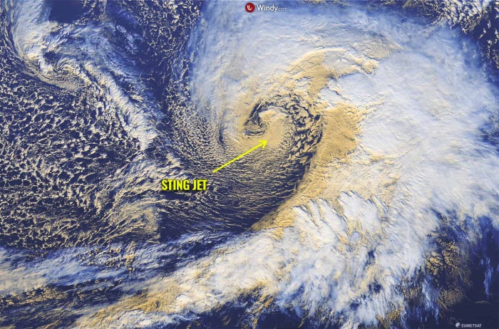
Attached below is a closer look into the whole storm on Friday. A great presentation of the fronts, dry conveyor belt wrapping into the core, and the textbook appearance of a sting jet.
We can easily estimate that the winds are violent, just by the look of the linear orientation of the clouds around the sting jet feature.
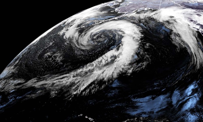
The system is providing an exceptional satellite view this weekend as its strength is near the peak intensity. Here is another look by the GOES satellite on Saturday local morning hours, provided by CIRA/RAMMB NOAA. Image is in Geocolor channel.
*A sting jet phenomenon is a narrow zone of strong winds, originating from within the mid-tropospheric cloud head of explosive cyclogenesis. Winds are enhanced further as the jet descends, drying out and evaporating a clear path through the precipitation. The evaporative cooling leads to the air within the jet becoming much denser, causing the acceleration of the downward flow towards the tip of the cloud head when it wraps around the cyclone center.
Windspeeds in excess of 90 mph (150 km/h) are often associated with the sting jet. This cloud, hooked like a scorpion’s tail, gives the wind region its name the “sting jet”.
The image above, provided by CIRA/RAMMB NOAA, shows an exceptional view of the storm’s core with several mesovortices embedded within a large circulation. Notice a massive dry conveyor belt wrapping into the core!
EXTREMELY RAPID INTENSIFICATION CONTINUES
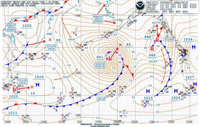
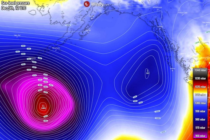
The central pressure of the low has pushed to 941 mbar by Saturday morning, which is even slightly deeper than weather models were predicted on Friday.
Here are the surface analysis data for the mean sea-level pressure estimates by the NOAA Ocean Prediction Center (OPC). The analysis reveals the storm’s evolution from its birth east of Japan on Thursday until Saturday morning local time:
- 941 mbar at 12 UTC, Dec 5th
- 949 mbar at 06 UTC, Dec 5th
- 956 mbar at 00 UTC, Dec 5th
- 960 mbar at 18 UTC, Dec 4th
- 969 mbar at 12 UTC, Dec 4th
- 983 mbar at 06 UTC, Dec 4th
- 993 mbar at 00 UTC, Dec 4th
- 998 mbar at 18 UTC, Dec 3rd
- 1005 mbar at 12 UTC, Dec 3rd
- 1007 mbar at 06 UTC, Dec 3rd
- 1013 mbar at 00 UTC, Dec 3rd
As we can see from the pressure analysis above, the central pressure in this extratropical storm had an impressive 38 mbar drop over the 24-hour period between Thursday 18 UTC and Friday 18 UTC. And another 19 mbar drop until Saturday 12 UTC.
That is indeed well beyond the threshold for explosive cyclogenesis and the pressure change was a remarkable 52 mbar drop over the past 24 hours!
The system has become a very violent North Pacific storm, bombogenesis process is now nearly completed as the system is fully matured and near its peak. Some additional drop in pressure is possible until Saturday night and the central pressure could even fall below 940 mbar!
Below is the initial forecast discussion regarding the system’s evolution this weekend until Monday when its impact will be the most severe to the Alaska coast and the Pacific Northwest of the United States and Canada.
DEEP LOW PRESSURE AND MAJOR 15m+ WAVES
Thursday’s evening satellite image revealed a quite impressive satellite picture of over the North Pacific. We could see the triple-tandem over the North Pacific to the south of the Aleutian Islands and this newly developing extratropical storm over the northwest Pacific.
On Friday, the system continues gaining its strength while moving northeast with a bombogenesis underway. It will become a monster North Pacific extratropical storm.
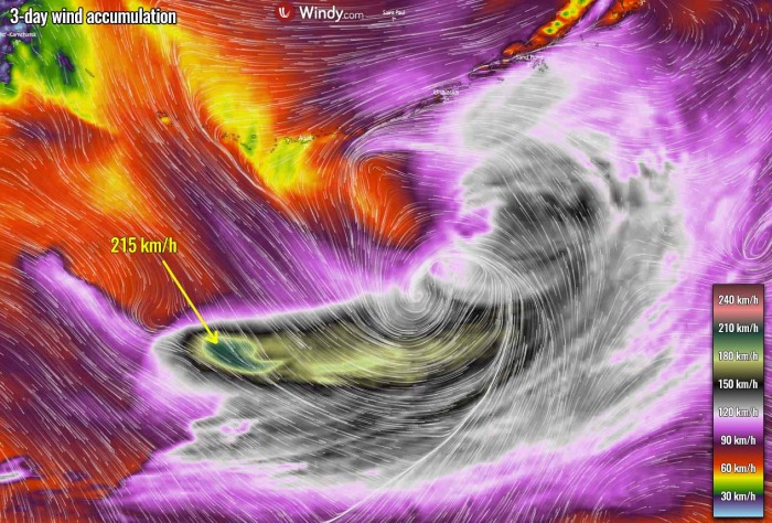
Violent, hurricane-force winds are expected to develop with the system. It will likely peak above 200 km/h. As we could see on the satellite images earlier, the sting jet wind maximum has developed.
Saturday, Dec 5th
The system will continue rapidly organizing through Friday night, on its way towards the Aleutian Islands and Alaska. Its central pressure will already push into around 945 mbar by Saturday 12 UTC (local morning). The pressure gradient will be extreme. Indeed this means violent, hurricane-force winds will result.
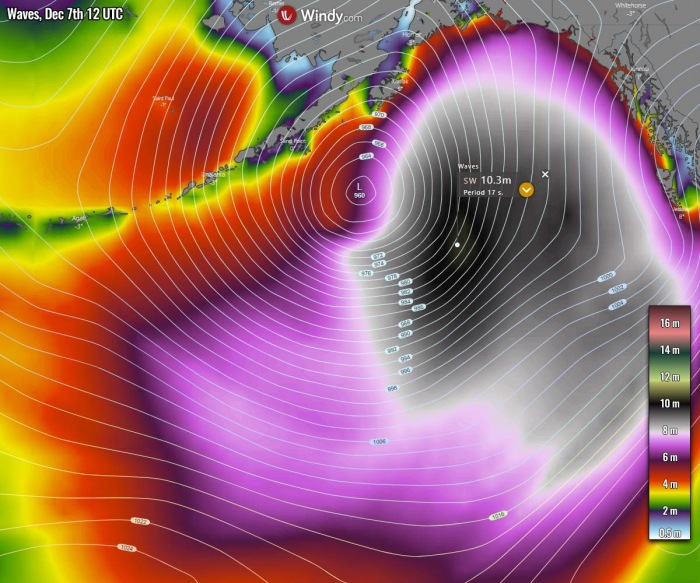
Such a violent wind force will generate massive waves, with very significant wave heights. The wave model guidance suggests those could even higher than 16 meters (52 feet), spreading to the south of the storm’s core. And those will be expanding across a broad area.
According to the weather models, the very rapid intensification should be completed by the afternoon hours on Saturday, with likely the minimum central pressure very near 940 mbar. The storm’s size will be even larger and its wind field wider.
Sunday, Dec 6th
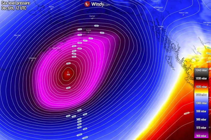
By Sunday local morning (12 UTC), it will begin its approach to the Aleutian Islands, having the central pressure below 950 mbar still. We can get an idea of how powerful the system will be on Sunday, by its large size at least. It will basically be covering the far North Pacific and the Gulf of Alaska.
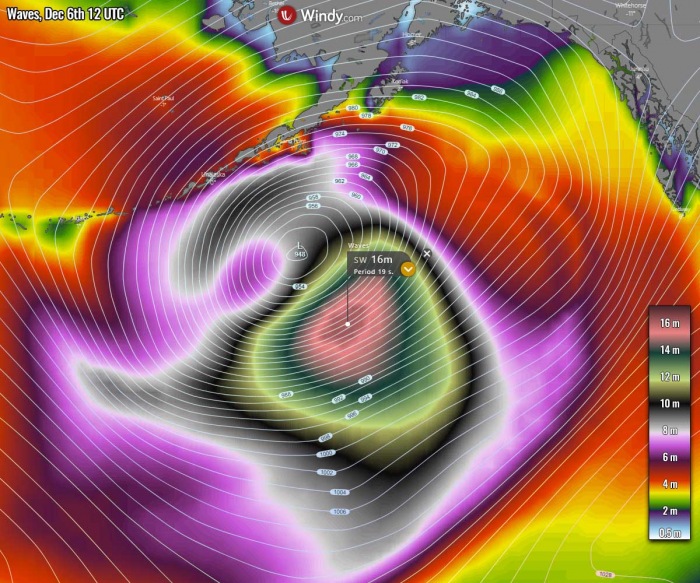
And if we look over the waves, it definitely shows we are dealing with a monster North Pacific storm. Waves will be spread across an even larger area and likely being 15-16 meters high to the immediate south of the storm’s center. Gradually expanding and moving towards the Gulf of Alaska and the Pacific Northwest of the United States.
We can also see that the system will be so large, that its northern portions will spread significant waves also to the north of the Aleutian Islands, over the Bering Sea. Spreading from the east-northeast directions.
Monday, Dec 7th
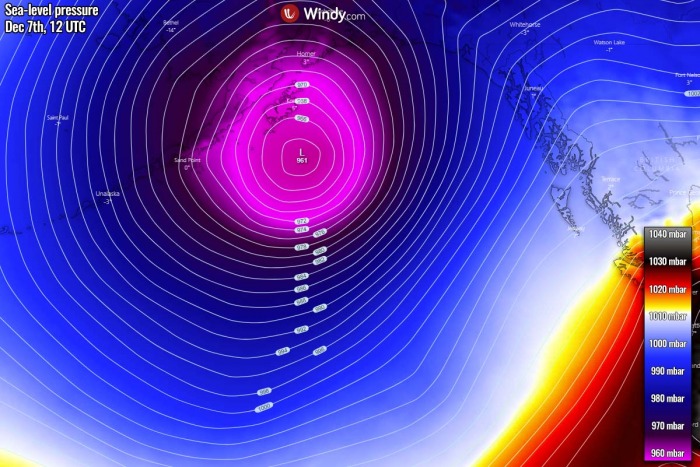
The extratropical storm finally loses its strength while it approaches the southeastern Aleutian Islands in the morning hours on Monday. While its central pressure will be around 960 mbar, so it remains a very strong system.
The storm is expected to move inland to southern Alaska while it continues weakening into Monday night.
Although the storm’s strength on Monday will be weaker than a day before, its size will maintain significant wave heights while the waves spread into the Gulf of Alaska, Southeast Alaska, Pacific coast of Canada, and the Pacific Northwest of the United States.
Waves will likely remain of around 9-10 meters high through Sunday afternoon when those enter the Gulf of Alaska.
Model guidance hints that weakening will be quite fast when the center moves closer to the coast and moving inland.
HURRICANE-FORCE WINDS OF 200+ KM/H / 125 MPH
The aforementioned developed sting jet wind maximum on Friday will likely continue into Saturday until the storm reaches its peak intensity overnight to Sunday. High-resolution model guidance hints that the jet will likely generate winds in excess of 200 km/h. Those are impressive 125 mph gusts!
And these winds are generated through Friday night and Saturday morning, so during the bombogenesis process when the most intense rapid deepening of the central pressure will be ongoing.
Actually, this is quite typical for extratropical storms of such scale and intensity as simulated this weekend.
It is, however, a good thing that the storm will be far away from any land areas at the time of the most intense winds. The strongest winds will remain over open North Pacific waters, roughly south-southwest of the Aleutian Islands.
LOTS OF RAIN AND SNOW FOR THE PACIFIC NORTHWEST
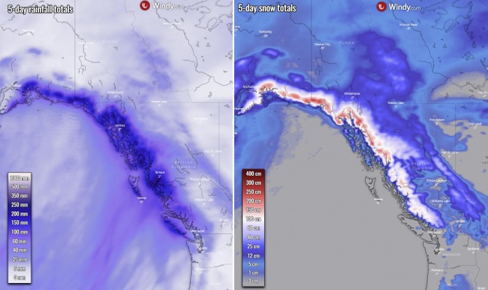
A strong wind pattern established in between this intense extratropical storm and the strong ridge and the surface high-pressure system over the western United States will maintain orographic rainfall along the Pacific Northwest. Up to southern Alaska.
Over the next five days, while the pressure gradient and southwesterly winds will be the most pronounced, the total rainfall accumulation could locally exceed 200 mm.
Those precipitations will indeed fall as snow further inland over the mountain range along with far western Canada and southeast Alaska. Weather models hint around 150-200 cm of fresh snow could be accumulated by mid-next week.
See also:
Don’t miss a chance for a nice gift for your friends, family or someone special… Weather calendar could be the perfect gift for them – see below:
