Grimsvotn volcano in Iceland is on an increased alert, after an earthquake swarm and a subglacial flood. The available data shows that the volcano is nearing critical pressure, now being in the final runup stages before an eruption.
Grimsvotn is currently the main candidate for the next larger explosive eruption in Iceland. As you will see from all the data, the latest activity has pushed it very near to an eruption, which could be just days away. The volcano is under increased monitoring, as it typically erupts in a violent explosive fashion, having an intense history of effects sometimes spanning the Northern Hemisphere.
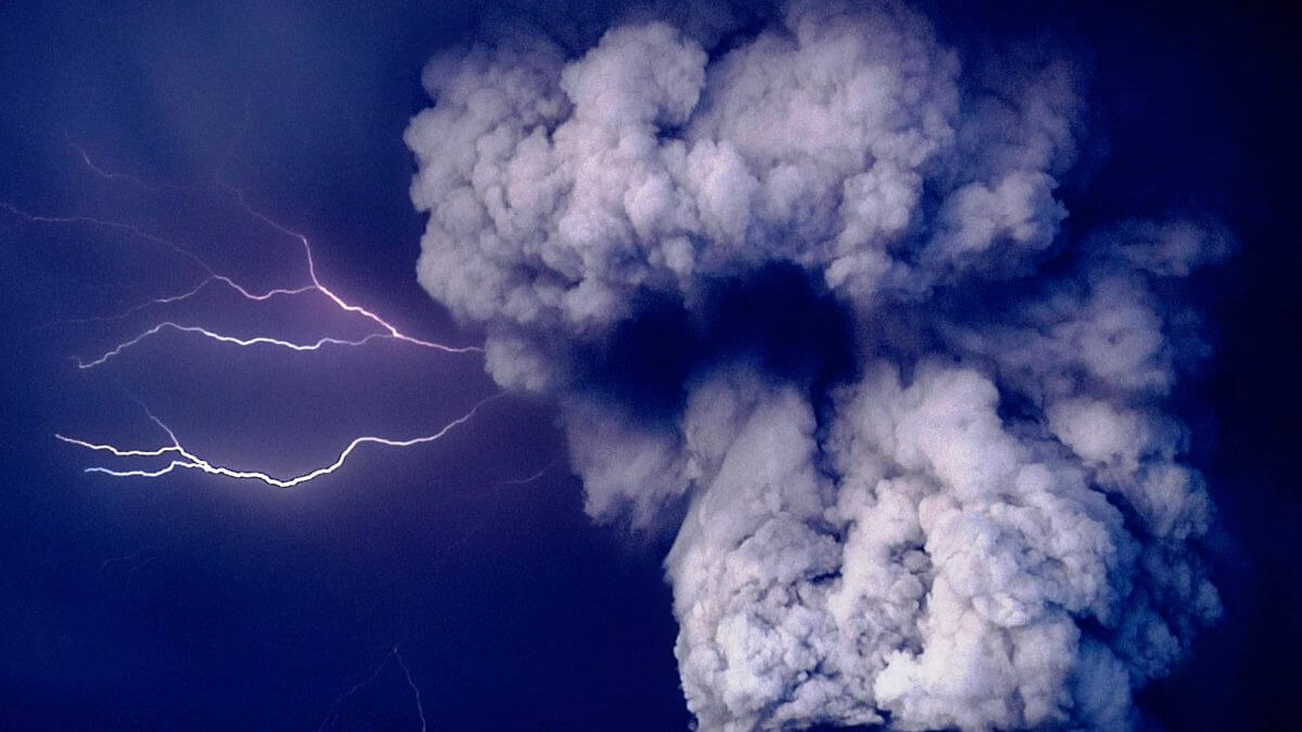
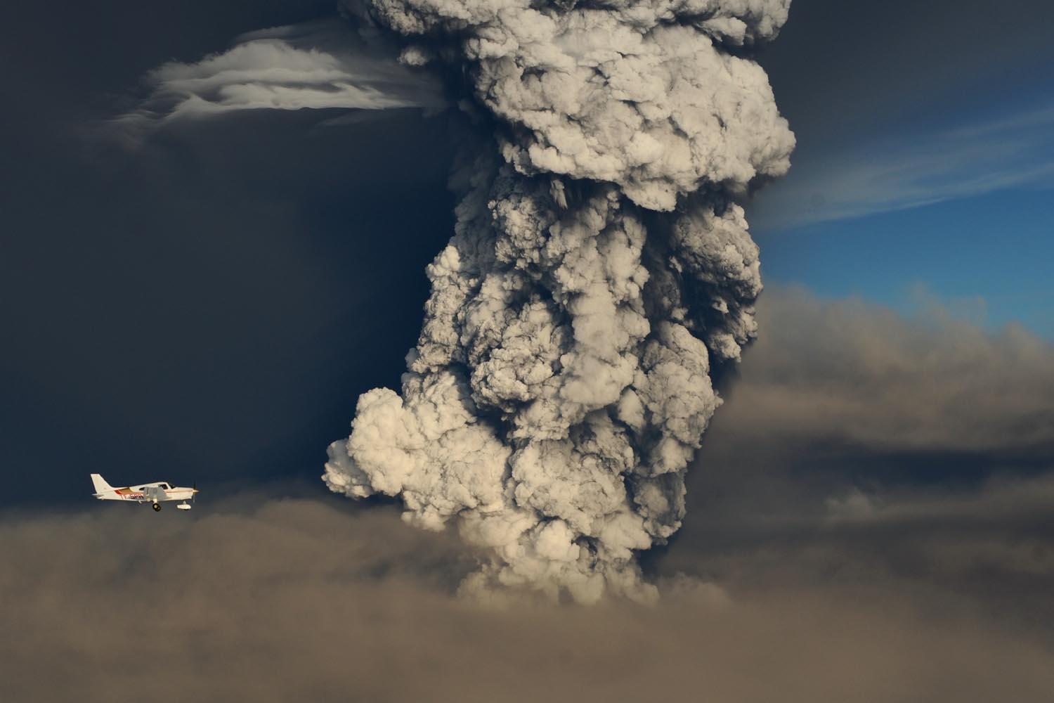
The image below shows the eruption column from Grimsvotn during its last eruption in 2011, by IMO Iceland.
FIRE MEETS ICE
Iceland is a volcanic island in the North Atlantic, and one of the most active volcanic regions in the world. As history shows, its eruptions can have powerful impacts on Europe, North America, and the entire Northern Hemisphere.
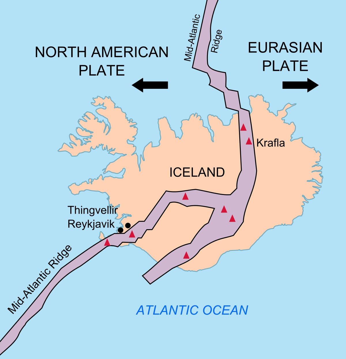
The island experiences constant earthquake activity because it sits on the boundary between the Eurasian and North American tectonic plates. This boundary is also known as the Mid-Atlantic Ridge (MAR). The plates are moving away from each other, effectively tearing the island apart. It is the only place in the world where the Mid-Atlantic Ridge rises above the ocean surface.
On the image below, you can see the spreading tectonic plates and where the Mid-Atlantic Ridge passes through Iceland. It enters in the southwest on the Reykjanes Peninsula, going towards the east, where it then turns north. Main central volcanoes are marked in red triangles.
But the tectonic plates spread apart across the entire Atlantic Ocean. So why is this location so special, that produced a large volcanic island over the millions of years?
The answer is a vertical plume of hot molten rock from the mantle, also called a hotspot, or a Mantle plume. It has been proven by extensive studies that it lies beneath Iceland (similar to the hotspot under Hawaii). It is more commonly called the Icelandic plume. The image below is a graphical presentation of the rising mantle plume beneath Iceland.

The high-pressure magma from the depths of the Earth has found its way to the surface in this plume. Following the path of least resistance, it pushed through the cracks between the spreading tectonic plates, starting to build an island.
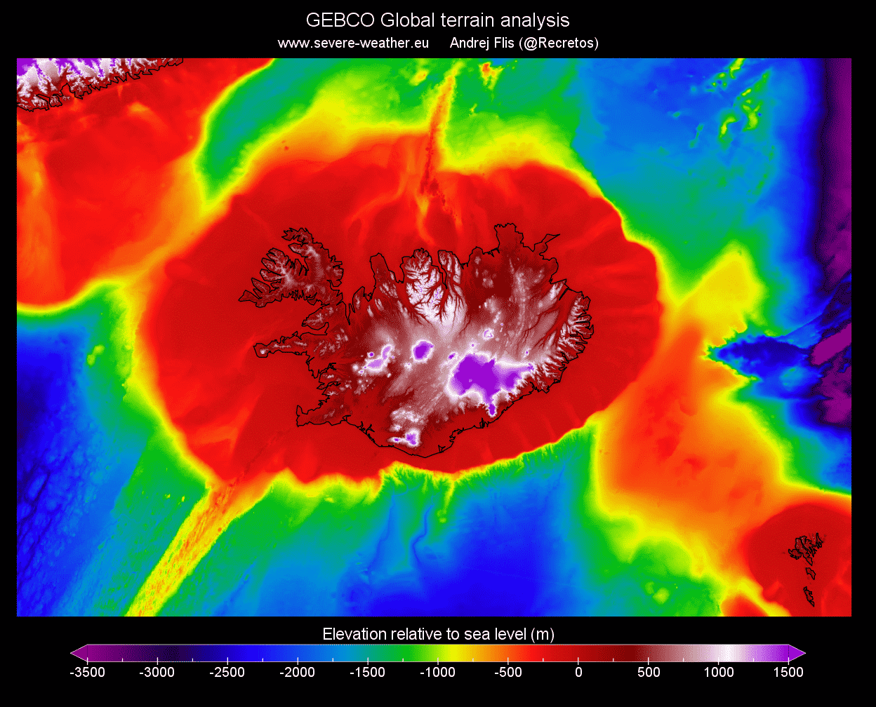
In the image below we can see the Earth’s terrain without the oceans. You can nicely see the Mid-Atlantic ridge coming from the southwest. And also you can see the large “lava pillow” of sorts, on which Iceland sits. It was produced as the mantle plume pushed through the spreading tectonic plates.
We produced a high-resolution video, which shows the daily earthquake locations in Iceland since January 2019. You can nicely see main earthquake activity is exactly on the Mid-Atlantic Ridge across Iceland, having constant daily activity. The main activity is focused on the southwest and the north. That is where the mid-Atlantic ridge enters and leaves Iceland.
The plume has its pulses or cycles, causing periods of higher and lower volcanic activity in Iceland. We have entered a new period of increased activity in recent years/decades. This plume lies under the whole of Iceland, but its very center lies under the largest Icelandic glacier called Vatnajokull.
Below is an image that shows the approximate center of where the plume connects with Iceland under the Vatnajokull glacier (black circle). You can also see the mid-Atlantic ridge in orange and volcano locations.
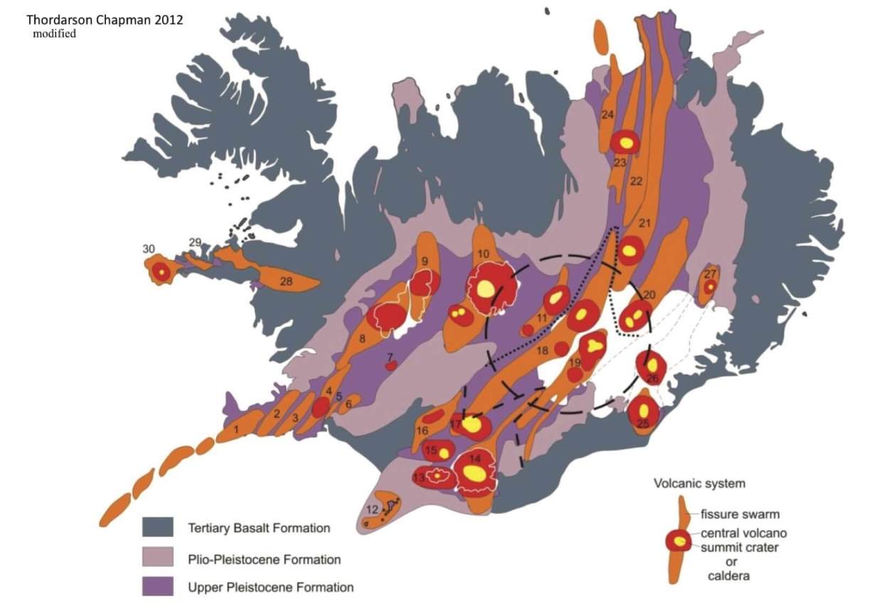
Vatnajokull is the largest glacier in Iceland and the largest ice cap in Europe. It covers roughly around 7.900 km2 but reduces over time. Under this glacier, many different volcanoes are hidden, covered by hundreds of meters of solid ice and snow. The image below shows the main central volcanoes beneath Vatnajokull, with Bardarbunga and Grimsvotn being the main/largest ones.

The Bardarbunga volcano last erupted in 2014, but the eruption occurred outside of the glacier. Magma has traveled below the ground for over 40km towards the northeast, before finally erupting.
The eruption was of the more peaceful “Hawaiian style“, and lasted for about 6 months (August 2014 to February 2015). Below is an image of the lava field outside Vatnajokull at the end of the eruption, covering 85 square kilometers (33 square miles) of land.

The other major volcano under the glacier, and our focal point for today, is Grimsvotn. It last erupted in 2011, and unlike the peaceful lava flow of Bardarbunga in 2014, it was very explosive. Grimsvotn is one of the major candidates for the next explosive eruption in Iceland, so we will take a closer look at its recent activity, as it could be just days away from an eruption.
Below is an image of the explosive eruption that started in Grimsvotn on May 21, 2011.

FAGRADALSFJALL VOLCANO ERUPTION 2021
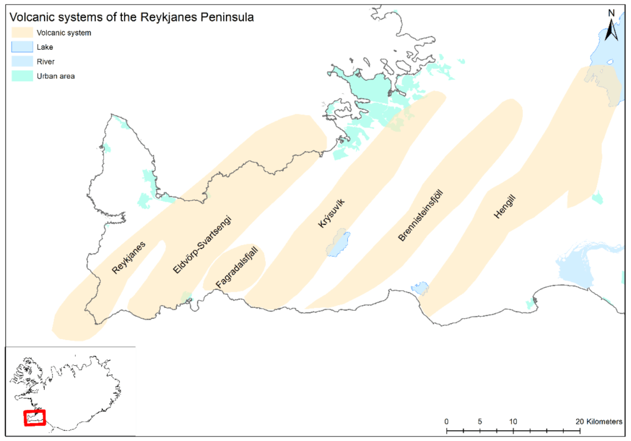
There is usually a volcanic eruption in Iceland every 4-6 years on average. The last eruption began on March 19, 2021, and ended in mid-September. As in 2014, this was also a more peaceful lava flow eruption, occurring in the Fagradalsfjall volcanic area. This area is found on the Reykjanes Ridge in southwest Iceland, seen in the image below, by the official volcano monitoring agency in Iceland, Icelandic Meteorological Office (IMO).
Below we have an image of the lava field during the eruption. The eruptive cones are glowing red, while the erupted lava is already cooling and turning dark in the process. There was near-constant lava spattering from the vents, which have been building cones above the eruption points. Photo by: Almannavarnir/Björn Oddsson.

The Icelandic Met Office (IMO) estimates that around 151 million cubic meters of lava erupted, (5.3 billion cu ft) covering an area of around 4.8 km2 (1.9 square miles). Below is a map from @geoviews, that shows the eruption cones (triangles) and the spread of the lava field.

EXPLOSIVE GRIMSVOTN VOLCANO
Grimsvotn is a subglacial volcano, which means that it is completely covered by snow and ice. It has very high thermal power, which means that it is melting the ice sheet from below, creating a lake under the ice, called Grimsvotn lake. This is a very important part of the volcano, as we will learn further below.
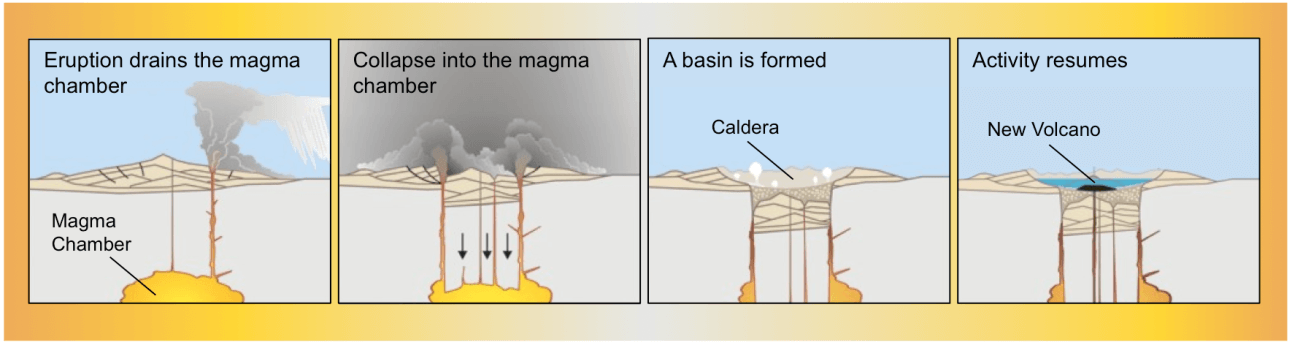
This is not your typical pointy-mountain volcano, but a caldera complex, made out of individual calderas. Its calderas were formed over the hundreds of years, after large eruptions.
A caldera is a depression in the ground, formed as the ground sinks after a large eruption. The ground sinks down into the void under the volcano, which was previously occupied by the magma that has now erupted. Some of the strongest volcanoes in the world are actually large calderas.
Grimsvotn erupts quite regularly, with its last 3 eruptions being in 1998, 2004, and 2011. This gives an average of about 6-7 years between eruptions. Its last eruption began on May 21 and ended on May 28, 2011. It was a large explosive eruption.
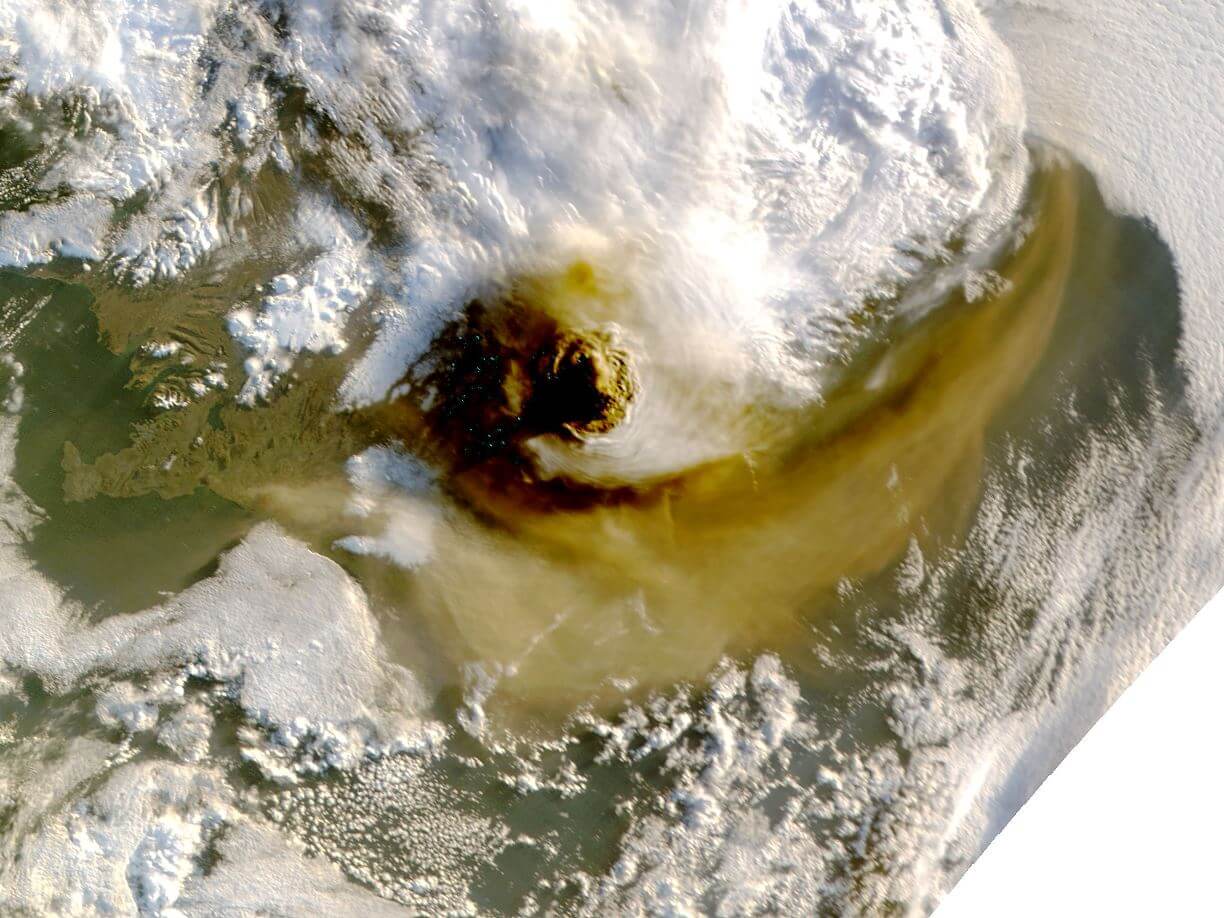
It is now more than 10 years since this event. But this was a big explosive eruption, so the volcanic system can take more time to recover and recharge. Below is a satellite image from NASA/MODIS, of the eruption plume and the ash cloud during the 2011 eruption.
The last eruption of Grimsvotn was the largest explosive event in over 100 years in Iceland. Its ash plume rose up to 20km (12 miles) high, creating a large ash cloud. The image below is a radar scan of the ash column, with its tops rising over 15km in altitude at the time of the scan.

The ash cloud caused minor air travel disruptions, canceling around 900 flights across Europe. That is a relatively low number, compared to 95.000 flights that were canceled just a year before.
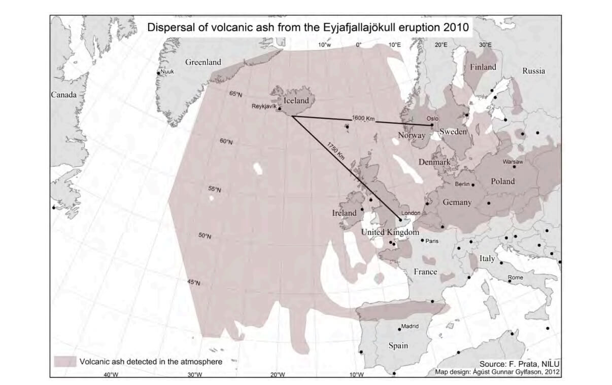
In the spring of 2010, the Eyjafjallajokull volcano erupted, sending an ash cloud directly towards Europe. It caused widespread air traffic cancelation, damaging the global economy for billions of dollars. The image below shows the ash dispersal over Europe in 2010, which locked down the airspace over the North Atlantic and Europe.
Grimsvotn’s 2011 eruption was much bigger than the 2010 eruption of Eyjafjallajokull, yet it caused only 1% of the total flight cancellations that we have seen during the 2010 eruption. The image below shows the rising ash column during the 2011 eruption, taken by Ólafur Sigurjónsson.
There were much fewer air flights canceled in 2011 because the high altitude winds carried the ash cloud mostly away from Europe. And also because new air traffic rules and protocols were introduced following the 2010 eruption. Flights are now canceled only when a certain concentration/amount of ash is reached or detected at the air traffic flight level.
But regardless of the new rules, if the winds would carry the 2011 ash cloud towards Europe, it would still cause heavy air traffic disruption.
We often hear that the Grimsvotn volcano is overdue for an eruption. But volcanoes are never overdue, as they can change their behavior at any time. The Grimsvotn volcano has had calm periods lasting over 15 years without an eruption, but that is a relatively rare occurrence in modern records.

But why are some eruptions in Iceland very calm with lava flows, and some can send ash clouds around the Northern Hemisphere? The answer is simple: ice.
Eruptions in Iceland can get very explosive from volcanoes that erupt under ice (a sub-glacial eruption). That is because the rising hot magma meets ice (or water/lake under the glacier) on its way to the surface, causing an explosive reaction between the two.
ROAD TO ERUPTION
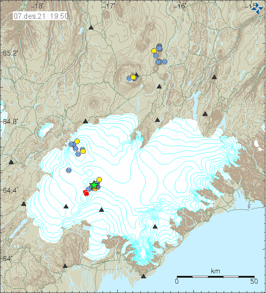
On Monday morning, December 6th, an M3.6 earthquake occurred in the Grimsvotn volcano, near the surface. This was unusually strong for this volcano and was the strongest earthquake in Grimsvotn since the last eruption. A total of 16 earthquakes occurred in Grimsvotn in this earthquake swarm, with smaller earthquakes now still following behind.
Below we have a map by the IMO, which shows the earthquake activity in the past 48 hours around the Vatnajokull glacier. The star shows the location of the M3.6 earthquake, which was at the Grimsvotn volcano. You can see several other earthquakes in the volcano, forming a linear pattern.
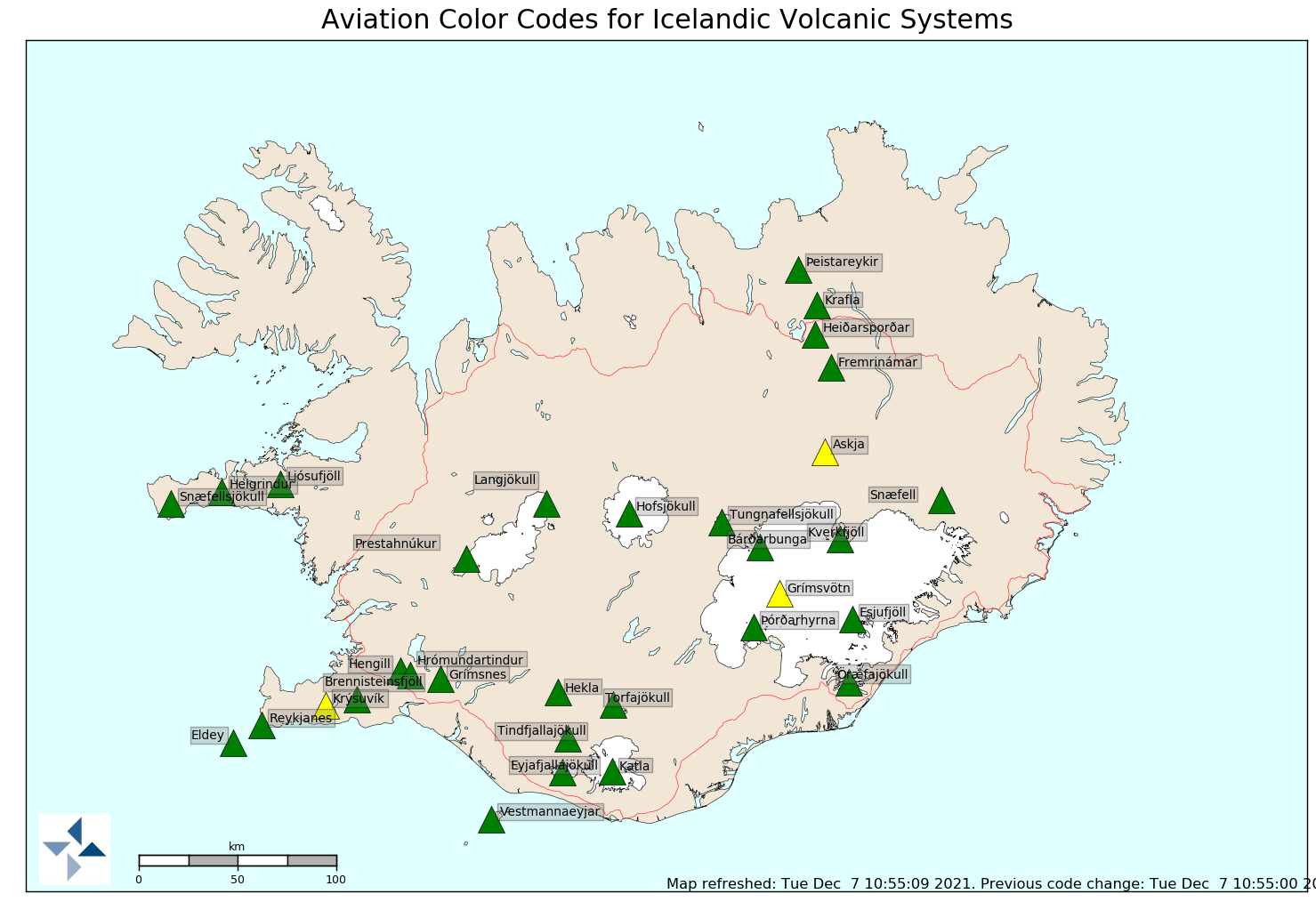
As a response to this earthquake swarm, the aviation color code for the Grimsvotn volcano was raised from yellow to orange. But since the activity has decreased significantly, the color code has been lowered from orange to yellow. Below we have the volcano alert map for Iceland, with 3 volcanoes under the yellow alert.
The earthquake swarm on its own is not such a big deal if it weren’t for two important factors. First, there was a glacial flood ongoing from the Grimsvotn volcano. And second, the volcano is already close to the “breaking point” with an eruption starting from just one more strong earthquake.
Looking at the flooding first, GPS measurements were showing that the ice sheet over the volcano has started subsiding which indicates that a flood from Grimsvotn was likely starting.
The ice sheet has subsided by about 60 cm in the first few days and the speed of subsidence quickly increased. These measurements indicated that it is most likely that water has started to leave from the subglacial lake under the ice sheet.
Below we have an image that shows the GPS measurements of the ice sheet above Grimsvotn. We can see that the ice sheet over the volcano has dropped by an astonishing 78 meters (256ft). The reason for this drop is that the water was flowing out of the subglacial lake, after which the ice sheet collapses down into the void left behind.

There are past examples of Grimsvotn eruptions starting following a flood. The loss of the water from the Grimsvotn lake reduces the pressure on top of the volcano and this can allow an eruption to begin. This happened in 2004, and before that in 1934 and in 1922. In 2004 the eruption started three days after the first observations were made of flood onset. There were a series of earthquakes in the days preceding the eruption.
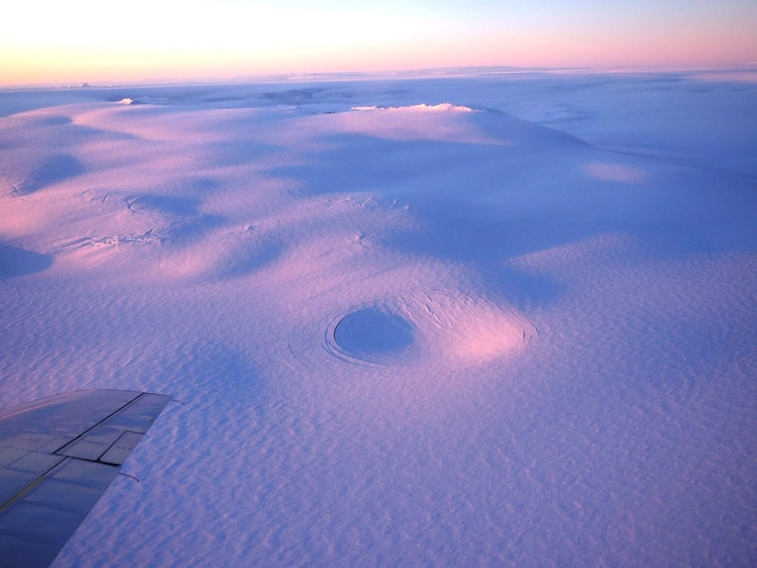
We can see a sinkhole forming in the ice sheet southeast of the volcano on the image below, likely as the water is being drained out of the subglacial lake. Photo by IMO – Njál Fannar Reynisson.
The image below shows the tremor levels from two monitoring stations near Grimsvotn. We can see the medium-high frequency tremor increasing over time, as the water was released from the subglacial lake. The tremor is caused by the vibrations of a large mass of water flowing under the ice. The ice sheet subsidence has decreased significantly and tremor is now weakening, so it is assumed that most of the water has now left Grimsvotn.
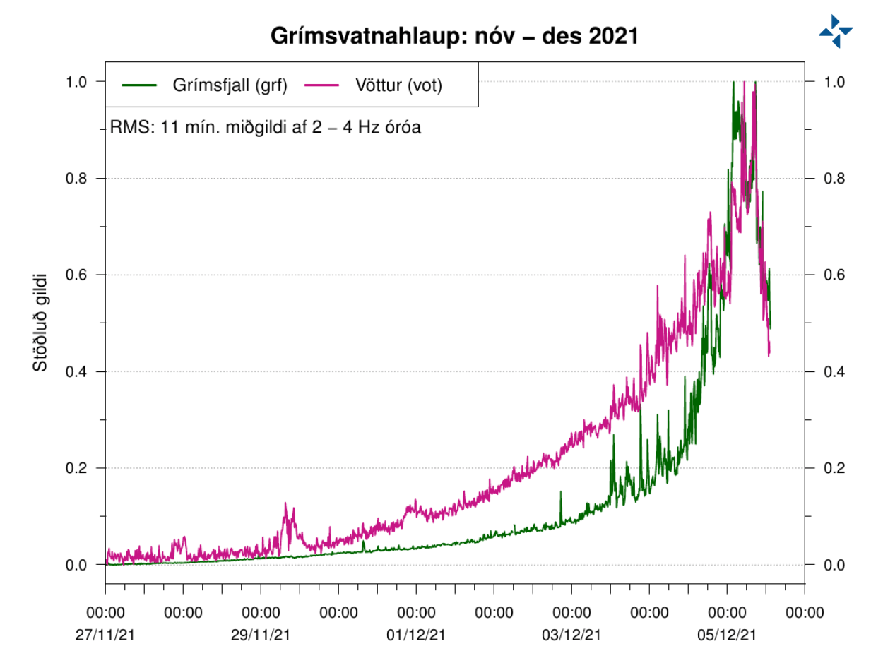
We can see the current tremor on the image below, from a monitoring station directly on top of the volcano. The tremor increase is nicely seen, and the return to previous levels. But we do see that the signal is not calm, as there is constant microseismicity occurring in the volcano.

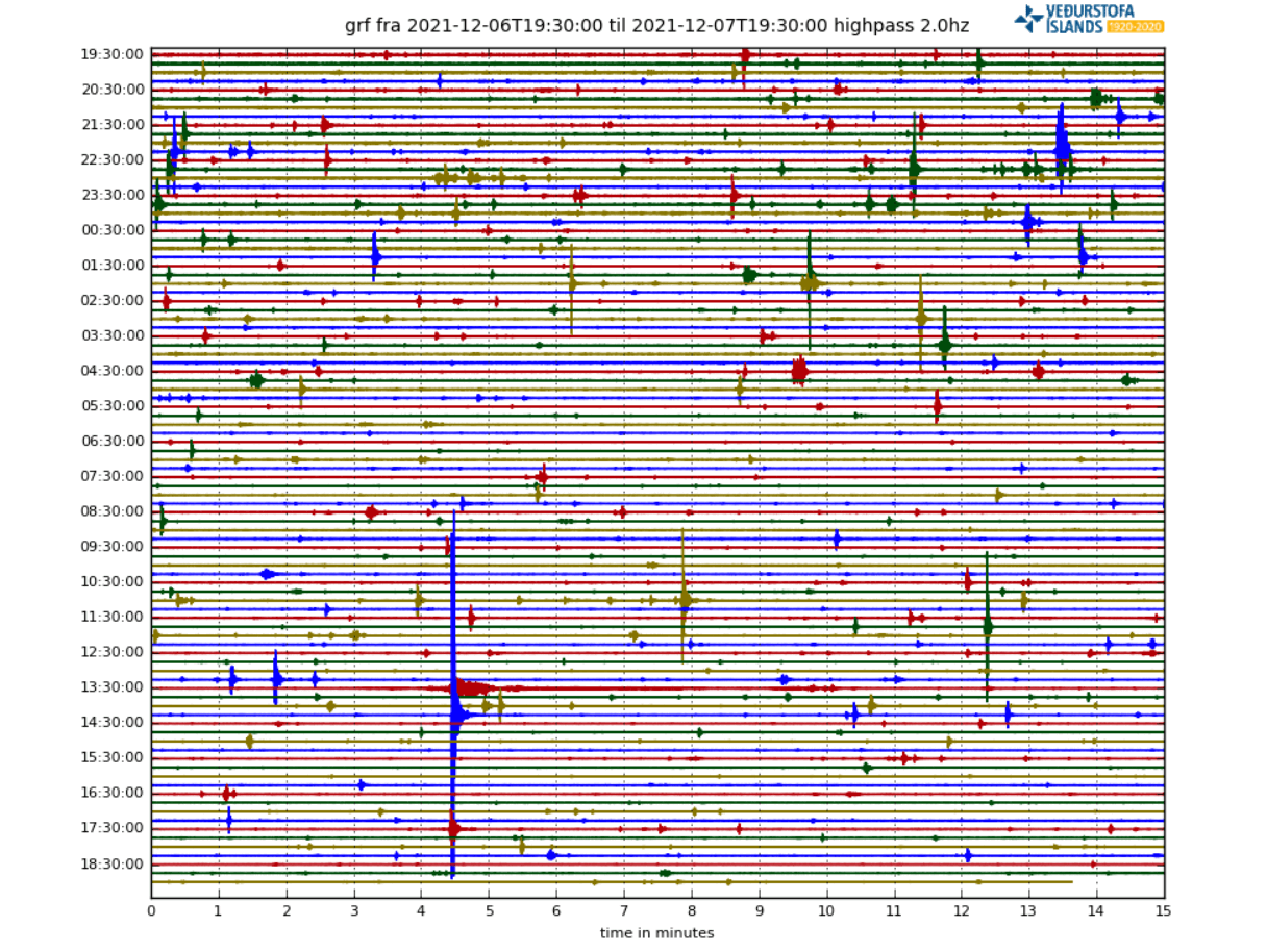
You can see the microseismicity more clearly on the seismograph display below, which shows many earthquakes occurring in Grimsvotn. Most are too weak to be properly located and registered. Some of the activity is also from the ice sheet activity.
Current data indicates that Grimsvotn has entered its last phase before the eruption. It is currently one of the top 3 candidates for the next big explosive eruption in Iceland, along with Hekla and Katla volcanoes in the southwest.
Grimsvotn is the only volcano of the 3, that was already at the orange alert level. It has regular earthquake activity, and all available data confirms that is at the eruption threshold levels. it can be set off by just one larger earthquake at the right place.
We have been tracking a slow but very steady increase in the number of earthquakes at Grimsvotn since late 2019. In March 2020, we saw the highest monthly earthquake rate since the eruption in 2011.
A steady and persistent increase in earthquake activity is usually one of the main signs that a volcano is slowly getting close to an eruption. The graphic below by IMO, shows the daily, weekly, and monthly earthquake rate over time, with the monthly rate nicely showing the steady increase over time.

But, earthquake numbers only tell us only one part of the story. Sometimes it is more important to look at the earthquake power and their energy release. Two or three strong earthquakes can have a bigger impact than 1000 smaller ones.
The image below by IMO shows the earthquake energy release (seismic moment) at Grimsvotn, and it is fairly simple to read. We see that a certain amount of energy release is needed for Grimsvotn to start an eruption, like in 2004 and 2011.
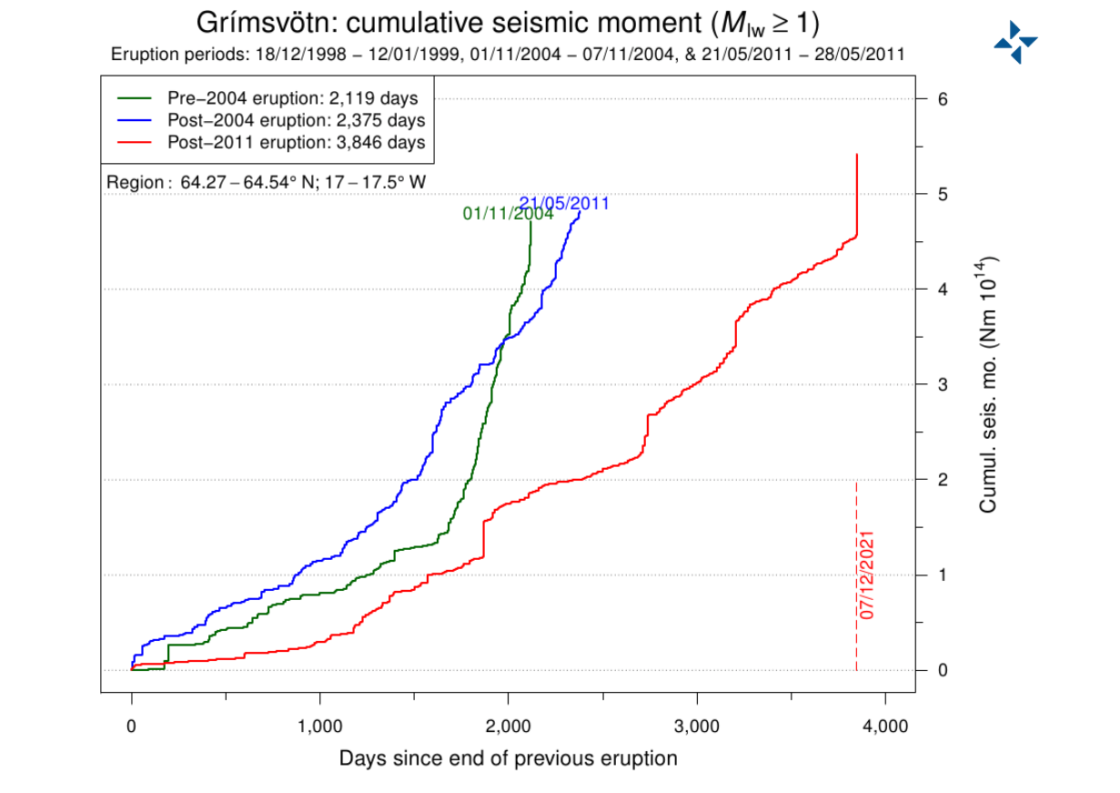
That is directly related to the pressure increase in the volcano, and we are now over the typical eruption threshold, thanks to the latest magnitude 3.6 earthquake. It was very energetic, creating a strong spike, pushing the total seismic energy released in Grimsvotn to the highest levels between eruptions in the modern records.
We produced a map of earthquakes at Grimsvotn from 2019 to 2021 to give you a better idea of where these earthquakes occur. The top outline is the rough area of the Grimsvotn calderas. The bottom outline is another volcano, which is a part of the Grimsvotn volcanic system. Colors show the depth of the earthquakes in meters.
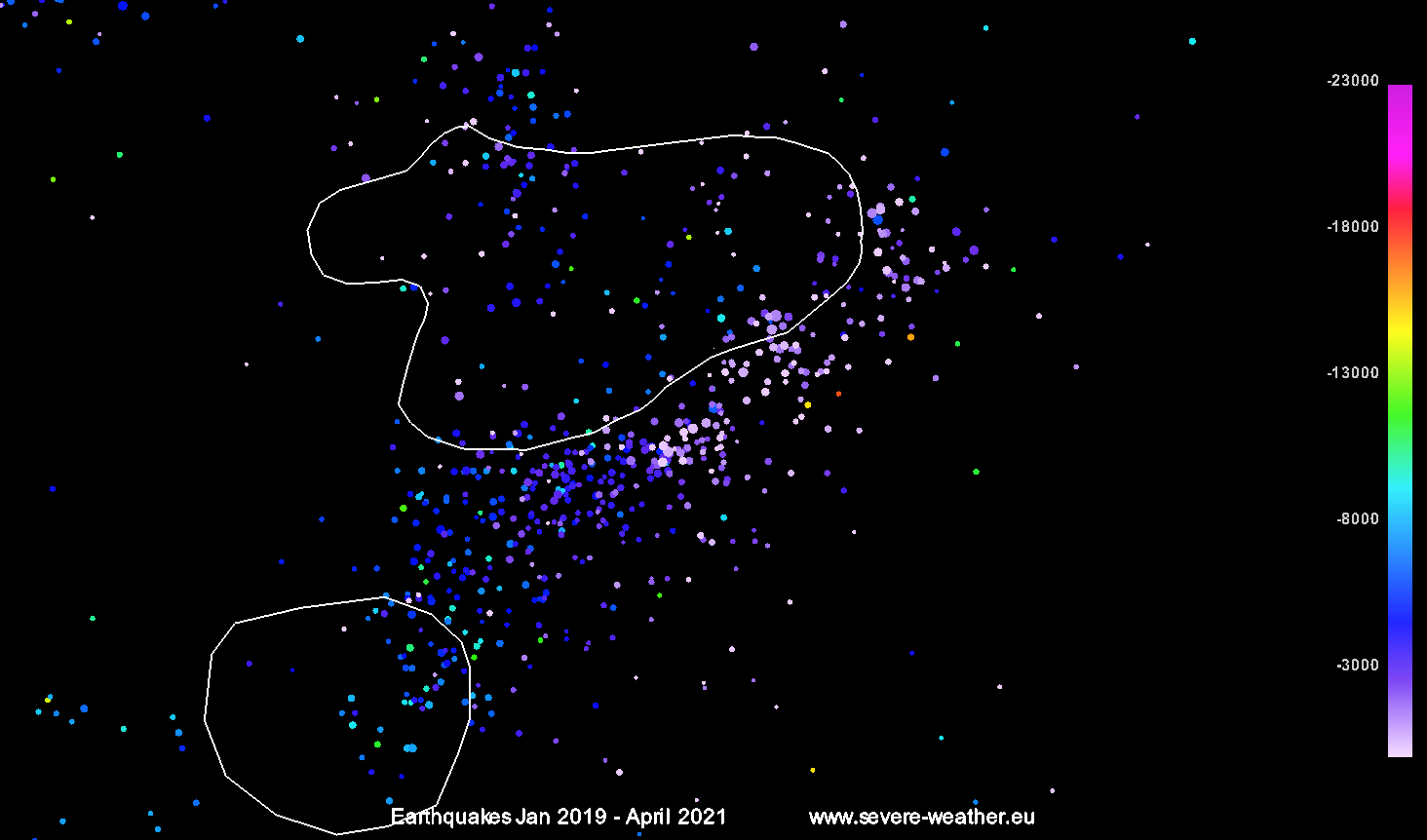
You can see that most of the earthquakes are on the south and east side of Grimsvotn. They mostly occur as the magma chamber below the volcano is recovering, and rebuilding pressure on the chamber walls. That causes strain on the crust around it, cracking the ground, which is what we detect as earthquakes.
But to be more certain for an eruption, we also need to look at ground movement around the volcano. We need to find signs that earthquakes are being caused by the fresh hot magma that is entering the volcanic system underground, accumulating there and increasing the pressure in the volcano. Just like inflating a balloon until it explodes. The process of accumulating magma and ground deformation is called inflation.
Grimsvotn is one of the most steadily inflating volcanoes in Iceland and also in the world, as seen on the monitoring equipment. As it lies very close to the center of the Icelandic plume, it has a constant feed of fresh material into its deep magmatic system.
The image below from IMO shows the data from a GPS station at Grimsvotn, which is monitoring the ground movement. What is most important here is the very bottom graph, which shows the ground moving up or down.

We can see that since the last eruption in 2011, the ground at Grimsvotn has raised by over 60cm (2ft). That is due to the magma accumulating under the volcano and causing enough pressure to push the ground up. It is a normal occurrence at most volcanoes that are getting ready to erupt. But there is no rule that would tell us how much a volcano has to inflate before it erupts.
ASH CLOUD FORECAST
Grimsvotn is a very likely candidate to have a large explosive eruption in the near future. It is powerful enough to have an effect on Europe and further around the Northern Hemisphere.
Another large explosive eruption (like in 2011) could severely limit air traffic again if the wind would take it towards Europe. That could have a global economic impact, which is why large explosive volcanoes in Iceland are closely monitored. Of course, we also have to consider the direct impact of ash on daily life in Iceland.
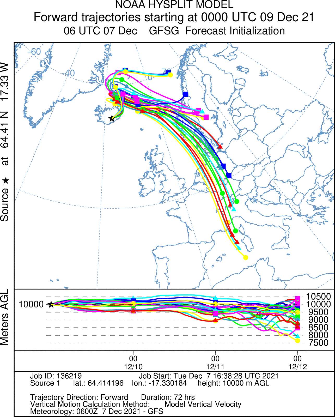
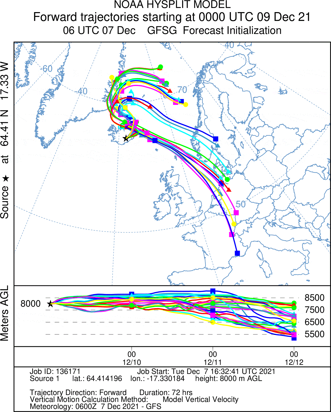
We produced several images below from the NOAA Hysplit model. It shows the movement of the ash cloud if Grimsvotn would have a medium-sized eruption on December 9th. This is just a simulation, forced by the weather forecast. One line is simulated every 12 hours, so we can see how the trajectory changes with time.
The first image shows the ash dispersal from 10km (33.000ft) altitude, which is at the aviation level. We can see that the ash cloud would first be dispersed to the north, but then quickly moves down over Scandinavia into central Europe. This would very likely close most of the airspace over mainland Europe.
Looking slightly lower, at 8km (26.000ft) altitude, we can see a similar story, with the ash cloud likely being dispersed over Scandinavia and into central Europe.
Creating a longer-term simulation below, we can see that the air motion at 10km (33.000ft) would take the ash particles far around the Northern Hemisphere. This is just a simulation, and a lot depends on the time of the eruption. If the eruption would occur on Dec 14th for example, the scenario could be far different. This is just used to show the potential to disperse the ash cloud.

VOLCANIC HISTORY
Grimsvotn actually has a far more violent past than just closing airspace. A series of eruptions from Grimsvotn around 10.000 years ago, deposited a large amount of ash over the region. The ash layer from these series of eruptions was found at numerous locations, from Iceland to the North-Atlantic ocean, all over northern Europe, in parts of central Europe, and also in the Greenland Ice Sheet.
This is known as the Saksunarvatn Tephra layer and is so widespread that it is being used as a common marking point in time when looking at the sediment layers and analyzing history. This ash deposit was not produced from a single eruption, but from a series of large eruptions from Grimsvotn in a 500 year period.
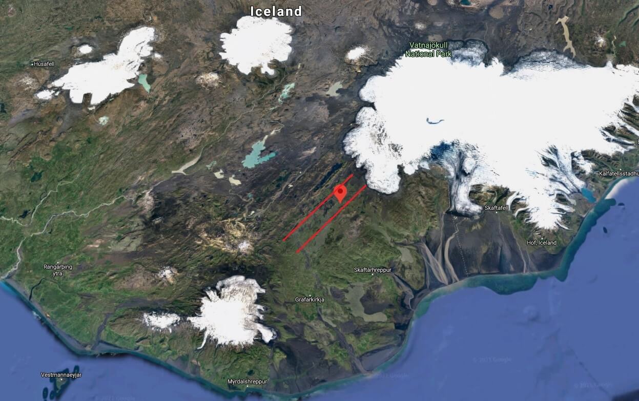
But much more “recently”, in 1783, an eruption occurred in Iceland, on the Laki fissure line, which is actually part of the Grimsvotn volcanic system. The eruption of the Laki volcanic fissure in the south of the island is considered by some experts to be the most devastating in Iceland’s history.
It caused the biggest Icelandic environmental, social, and economic catastrophe. 50 to 80 percent of Iceland’s livestock was killed, leading to a famine that left a quarter of Iceland’s population dead.
The volume of lava that erupted was large. Nearly 15 cubic kilometers (3.6 cubic miles) of lava erupted, which is the second-biggest recorded on Earth in the past millennium. Below is a map, showing the location of the Laki fissure line inside the two red lines.
The impact of the Laki eruption was huge and extended well beyond Iceland. Global temperatures dropped, with crop failures and famine in Europe as millions of tonnes of sulfur dioxide and hydrofluoric acid clouds were released into the Northern Hemisphere. Some experts have suggested that the consequences of the eruption may have played a part in triggering the French revolution, but this is still a matter of discussion.
Laki is a part of the large Grimsvotn volcanic system, which extends well beyond the main Grimsvotn caldera complex. It includes several other volcanoes on the same line towards the southwest of Grimsvotn. Another Laki style and size eruption in our lifetime is unlikely, but not entirely impossible.
The main global effects from Grimsvotn in the near future are large ash clouds, that can disrupt the air traffic, impacting the already fragile world economy after the Covid-19 crisis. In a strong explosive eruption event, ash deposits are also likely in Europe.
We will keep a close eye on Grimsvotn and all the volcanoes in Iceland, informing you of any significant development. The official agency in Iceland for monitoring volcanoes is the Icelandic Meteorological Office (IMO), where you can find live data, additional information, and all official warnings.