The meteorological winter season 2021/22 has begun on Wednesday this week, while the days continue to produce some significant wintry weather conditions across parts of Europe. The dynamic and progressive weather pattern continues into the coming week with a violent North Atlantic storm Barra, heading for Ireland and the UK with potentially severe damaging winds and major waves.
On Monday, the large and deep trough sitting over the North Atlantic will introduce a rapidly deepening surface low, fast-moving from eastern Canada towards western Europe. The low will have a tendency to become explosive cyclogenesis before reaching Ireland coast early Tuesday morning.
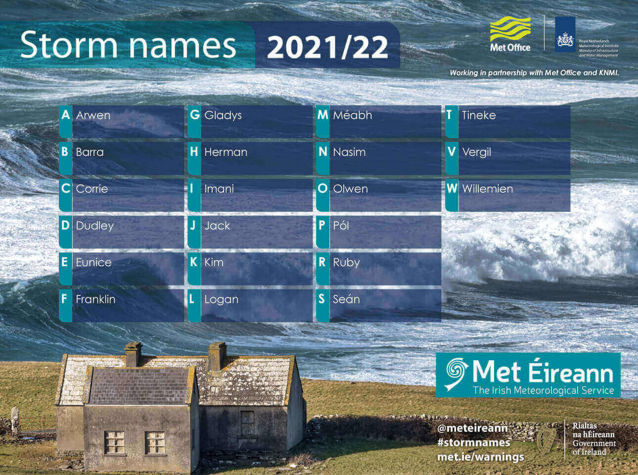
This deep frontal system will get its designated name Barra, the second named storm of this winter season 2021/22, and is forecast to bring unsettled and dangerous weather conditions across Ireland, Scotland, Wales, and the UK starting Tuesday into Wednesday. Travels will locally be disrupted by violent winds and rain squalls. A good amount of snow will blast the Scottish Highlands to the north.
Barra is an Irish name that made it on the list for the season 2021/22, a total of 22 names that are designated this year. Since 2015, the Irish Met Éireann and the Met Office (UK) have been working together on the storm names partnership to help raise awareness of the potential impacts of severe weather and were joined by KMNI (Netherland) in 2019.
The first one this year was a storm Arwen, a powerful extratropical cyclone that was part of the 2021–22 European windstorm season. It affected the United Kingdom, Ireland, and France, bringing strong winds and snow at the end of November (25-27th). Wind gusts peaked at 177 km/h (110 mph) with the lowest pressure recorded as 973 mbar. Storm Barra is forecast to be much stronger.
Storm Arwen caused at least three fatalities and widespread power outages across the areas affected. People were killed by falling trees. Around 120 trucks were stuck on a stretch of motorway near Manchester by deep blowing snow, trains between Newcastle and Edinburgh were canceled. The storm’s worst-hit was for parts of the north of England, Scotland, and Northern Ireland from late Friday and early Saturday.
Before we check out the further in-depth details on the upcoming storm Barra, here is a quick overview of how the exploding surface cyclone and a violent windstorm will emerge into western Europe from Monday through Wednesday.
Winds are expected to be severe, locally damaging with potentially even hurricane-force speeds along the western-southwestern coast of Ireland. Destructive waves with heights up to 40+ feet are well possible as well.
This system will be a classic bombogenesis, quite a popular term used by meteorologists worldwide. These cyclones happen when a cold air mass collides with a warm air mass, such as cold air over warm ocean waters. The formation of this rapidly strengthening surface low is a process called bombogenesis, which creates what is known as a bomb cyclone.
BOMB CYCLONE BARRA – WHAT IS IT AND HOW SUCH STORM FORMS?
The intensification of the storm Barra will be rapid to an extreme in its final stages before reaching western Europe. It is quite likely we will see an impressive conveyor belt wrapping into the deep low with a pronounced warm seclusion Monday night. This will bring the development of a violent/destructive wind field near the center of the cyclone.
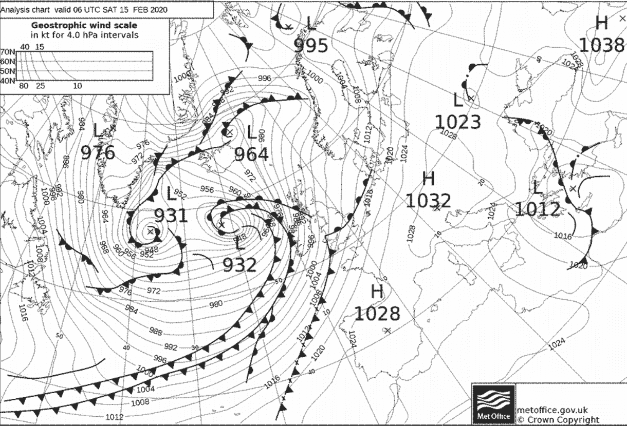
Weather models are quite consistent with the pressure falls once the low enters its rapid intensification overnight to Tuesday, entering bomb cyclone phase. An example of a bomb cyclone can be seen in the satellite below – this is the powerful Atlantic storm Dennis in mid-February 2020.

Note: A deep low is classified as a bomb cyclone when a system is intensifying very rapidly. Bomb cyclones form when explosive cyclogenesis (also known as bombogenesis) with the rapid deepening of its barometric pressure occurs. Generally, a pressure falls of at least 24 millibars (a millibar measures atmospheric pressure) within a 24-hour period is needed that the system needs to meet criteria to be classified as a bomb cyclone.
Just like a normal extratropical cyclone, a bomb cyclone gets its energy from variations in the temperature, precisely between the warmer temperatures towards the Equator and cooler temperatures towards the Arctic region, as well as vertically throughout the atmosphere. This type of cyclone is different from tropical cyclones, which get their energy from extremely warm sea surface temperatures in the tropical region.
During the cooler months, the east coasts of the North American continent are the perfect breeding grounds for these types of cyclones. The interaction between cold continental air and warm, moist ocean air provides lots of energy for a cyclone to rapidly develop or literally explode.
Bomb cyclones are quite common in the winter months in the North Atlantic, but they can occur all year round, including systems that rapidly reform from a decaying tropical cyclone when they travel far north towards Europe sometimes.
Each year, there are about 70 bomb cyclone formations worldwide. About 50 of them (two-thirds) are in the Northern Hemisphere, particularly off the east coasts of the U.S. and the North Atlantic, as well as in the northwestern Pacific around Japan. Australia also experiences several bomb cyclones each year, although they don’t tend to intensify as rapidly as the North Atlantic or Pacific storms.
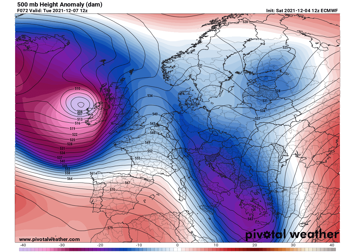
PROGRESSIVE WEATHER PATTERN OVER EUROPE IS ESTABLISHED
This weekend, the pretty dynamic weather pattern over Europe continues. A large and deep upper trough is blasting the central parts of our continent. Another snowstorm is hitting the Alpine region and parts of central Europe, with the majority of fresh snow over Austria, partly also over Czechia, Slovakia, and Slovenia.
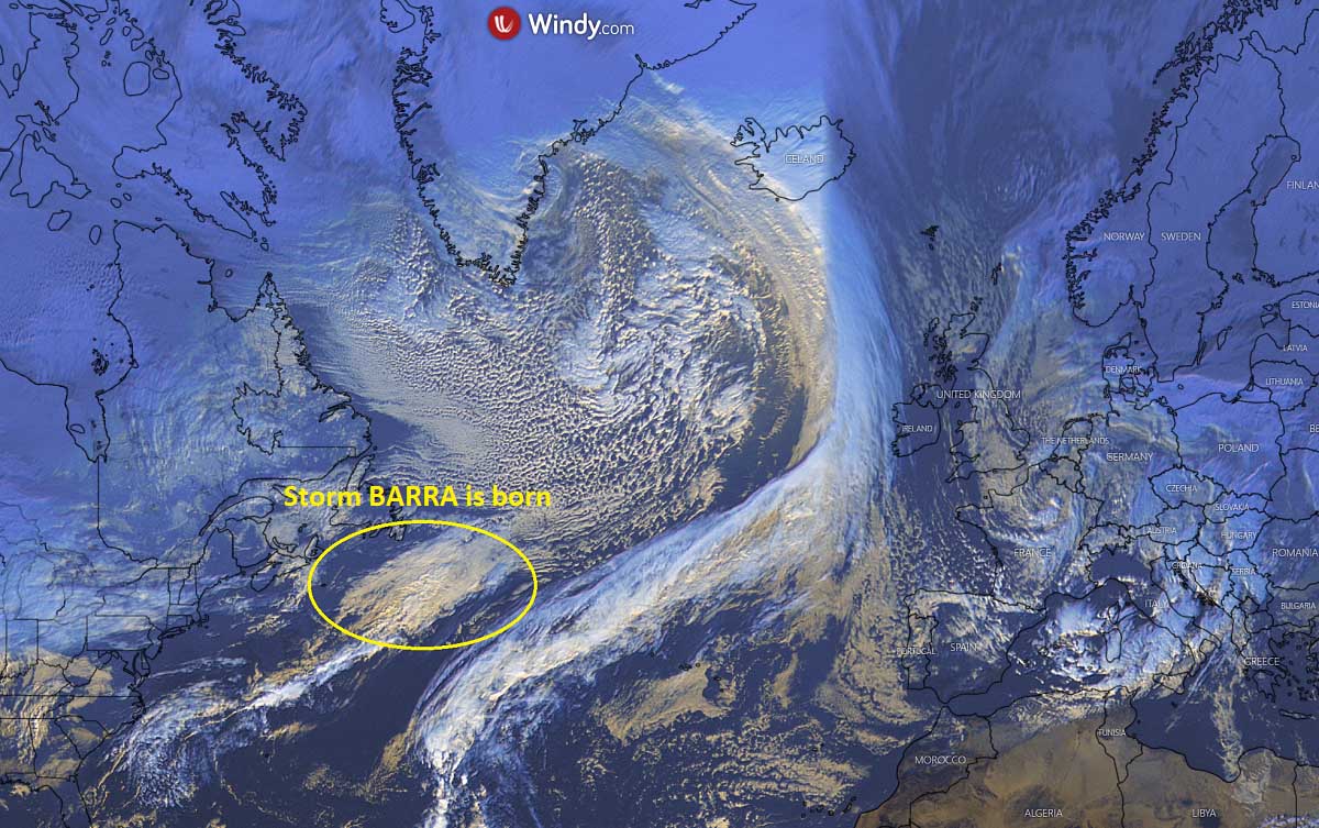
While the large low is seen over the North Atlantic, a wave that will become storm Barra is already seen to the east of Newfoundland this Sunday.
The progressive weather pattern means we are experiencing unsettled weather conditions, with dynamic and often changing weather conditions. In other words, meaning we have frontal systems disturbances traveling across Europe several times per week. It has been the case since mid-November, thanks to the well-established blocking Highs over northern Europe and the Azores.
This typically means we have more significant zonal flow wind patterns across the North Atlantic, delivering air masses roughly from west to east. With a deep trough and a lot of cold air mass in the mid-upper levels further north towards the Arctic region, deep cyclones and frontal systems are born over the Atlantic and travel towards Europe, colliding with already cooler weather conditions spread over the continent.
Recently, decent amounts of snow have been reported from the UK, northern Spain, central Europe, over the Alps, and indeed over Scandinavia. Actually, a lot of show has already accumulated along the southern Alpine flank, from 100-200 cm in places.
Farther north, a huge reservoir of seasonably very cold temperatures has overspread most of Scandinavia, precisely Fennoscandia. Temperatures have been pushing down to nearly -35 °C in the most exposed area, especially over the Lapland region across northern Sweden, Finland, and Norway.
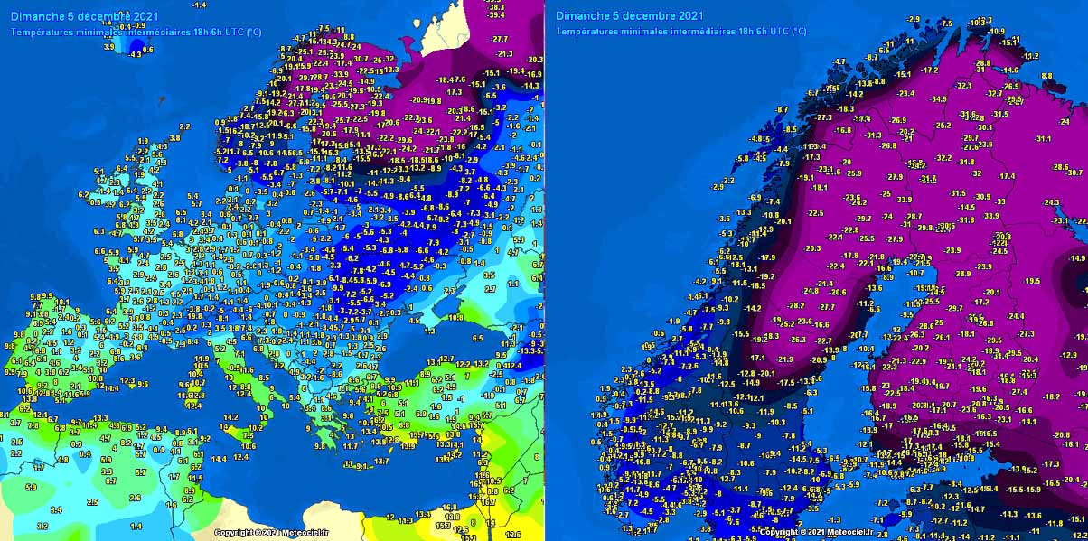
The attached maps above represent the morning temperatures on Sunday this weekend. Extreme cold continues across Lapland, and that is even around 10 degrees Celsius below normal in early December there. Such cold across northern Europe is forecast to continue for at least another week.
A NEW WEEK STARTS WITH A RAPIDLY DEVELOPING STORM BARRA TOWARDS THE IRELAND AND UK
Starting early Monday, a wave ejects off eastern Canada and it will be moving pretty fast across the North Atlantic towards Europe. In response to another intrusion of the much colder air mass from Greenland into the North Atlantic, the southern lobe of the Polar Vortex circulation will lead to an organizing surface depression somehow in the middle of the Atlantic.
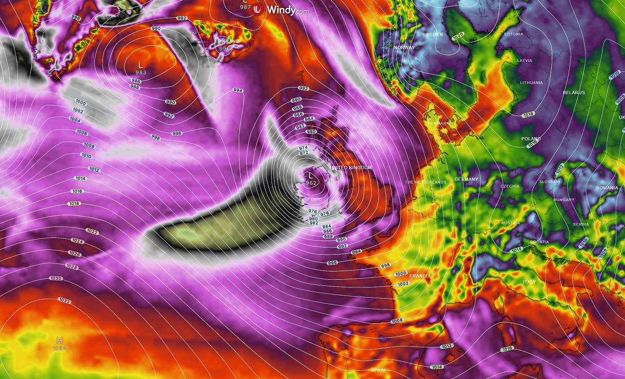
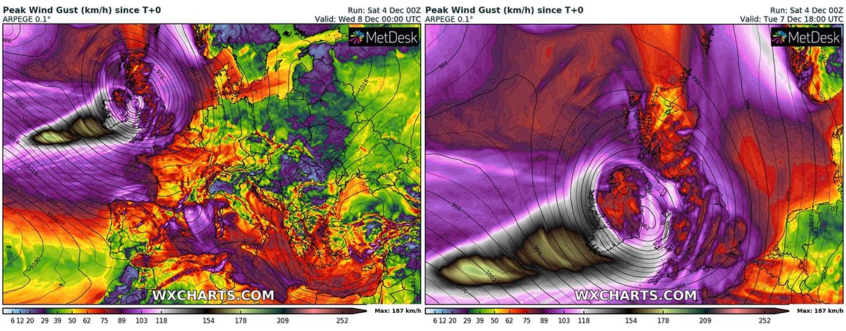
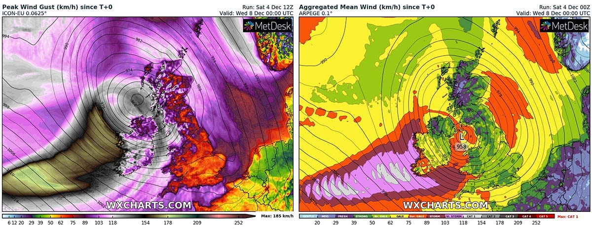
The surface pressure will be dropping rapidly as the general weather model consensus hints at the pressure falls of 15-20 mbar change in less than 12 hours from Monday afternoon onwards. Bottoming out around 955 mbar on Tuesday late morning or early afternoon near the western coast of Ireland.

That will be a result of nearly 45-50 mbar change in about 24-30 hours, so an extremely rapid pressure drop to say at least. More than enough for a bombogenesis classification. The progress of the pressure falls and storm movement is seen on the following chart.
On Monday evening, the pressure will already be in the low 970s mbar with an already well-defined frontal structure and intense rainfall. Storm Barra gets even better organized overnight into early Tuesday, gradually approaching Ireland with intense rain/wind squalls prior to daylight. Once the center of Barra goes ashore to Ireland, the main front squalls will be blasting across Wales and southwestern England.

North Atlantic storm Barra will also bring quite a lot of rain into western Europe, especially across Ireland and the western UK, Scotland, including Wales. Some areas are about to receive up to about 80-120 mm of rain through Wednesday evening and rivers could lead to flooding.
Below is the comparison chart of ARPEGE and ICON-EU models, both hinting at a similar picture regarding the swaths of the strongest and the most excessive rainfall amounts.

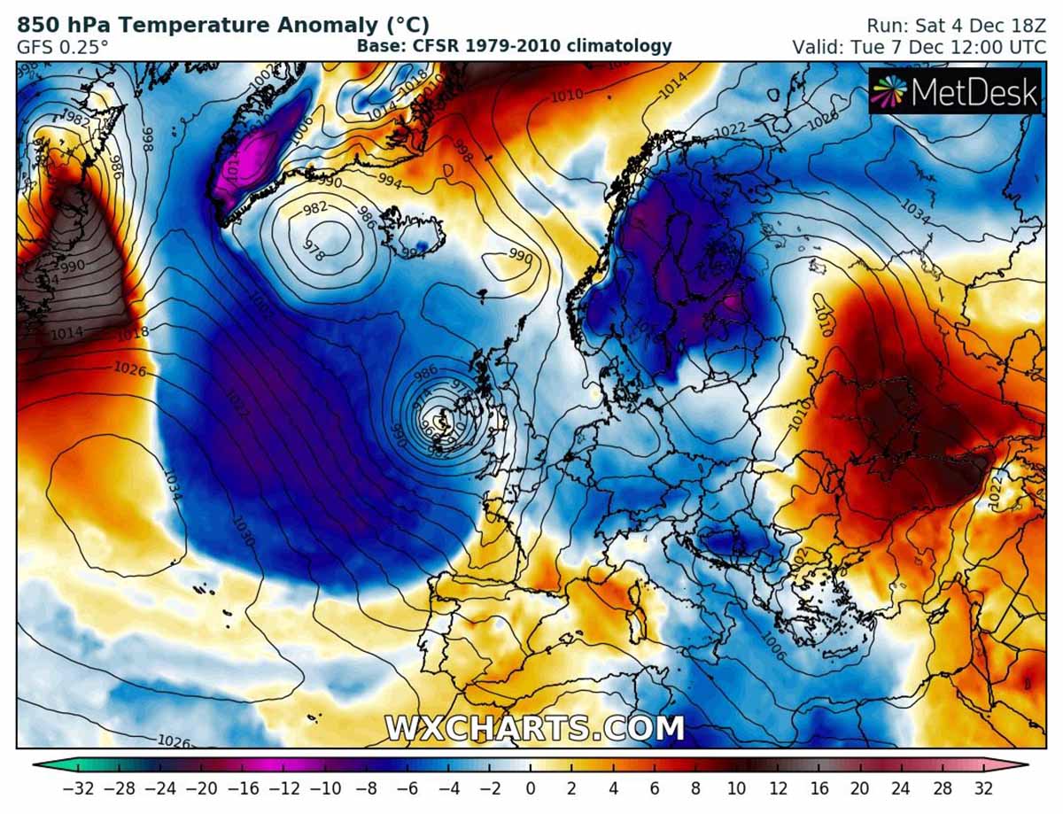
Behind Barra, a large pool of much colder air mass will spread across the Atlantic and gradually push towards southwestern Europe through Wednesday and Thursday.
Notice also how the extreme cold remains in place across northern Europe, with temperatures about 8-10 °C below normal from the Baltic region into Sweden, Norway, and Finland. Temperatures will continue to stay well below zero for days, with mornings below -30 °C in Lapland.
Once the storm Barra is over after mid-week, some cold will also spread across western Europe and continue into the next weekend. The southern part of Barra will also lead to a secondary low forming towards central Europe and the northern Mediterranean that will develop another winter storm with fresh deep snowpack for the region.
STING JET COULD PRODUCE HURRICANE-FORCE WIND GUSTS UP TO 200 KM/H
Violent, hurricane-force winds are very likely to develop with the system, thanks to its rapid intensification and bombogenesis process on Monday night. The highest wind gusts will be above 160 km/h, possibly even up to near 200 km/h within the so-called phenomenon – a sting jet. A wind maximum that often follows in these rapidly developing surface cyclones in the North Atlantic.
A sting jet is known as a narrow zone of particularly severe (violent) winds, originating from within the mid-tropospheric cloud head of explosive cyclogenesis. The winds within the sting jet are enhanced further as the jet descends, drying out and evaporating a clear path through the precipitation.

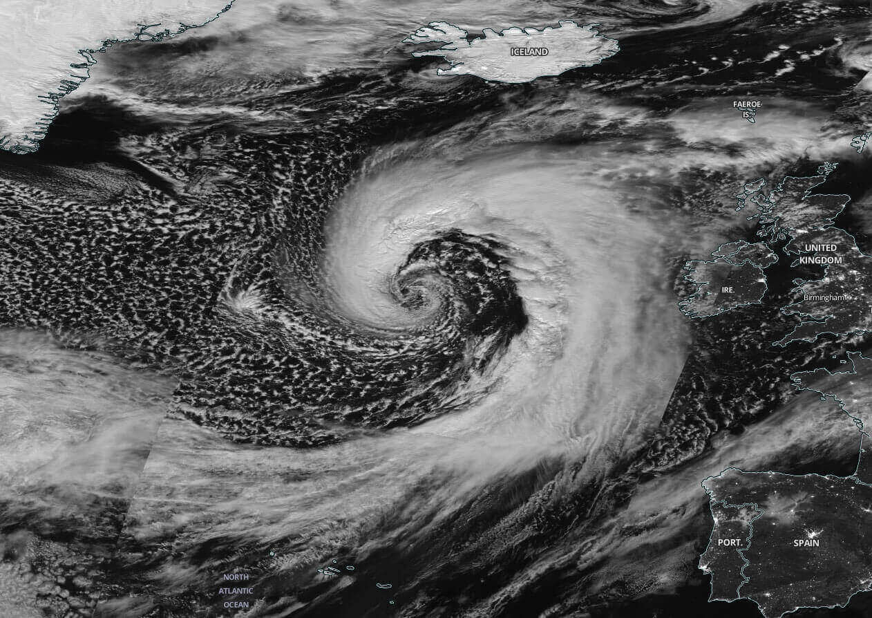
This evaporative cooling leads to the air within the jet becoming much denser, causing the pockets of air mass acceleration of the downward flow towards the tip of the cloud head when it wraps around the cyclone center. Below is a sample satellite of the textbook appearance of a sting jet with Atlantic cyclone Jorge at the end of February 2020.
The aforementioned development of a sting jet wind maximum on Monday night into Tuesday will spread across the long swath until the storm Barra reaches its peak prior to the hard impact on the Irish coast sometime on Tuesday. The high-resolution model guidance hints that the jet will likely generate winds up to nearly 200 km/h. Those are impressive 125 mph gusts and part of them could even reach the Irish coast.
How intense and where exactly the sting jet will develop is still a bit uncertain at this moment, but the majority of the high-resolution weather models, including the global GFS and ECMWF models, are hitting at its development once the explosive bombogenesis process starts Monday night.
Attached below are additional comparison charts by the ICON model (besides the ARPEGE model above) with the slightly different track of the Atlantic storm Barra that reflects the swath of the strongest hurricane-force winds. However, the cyclone will be very deep as we could have seen from charts above, possibly in the mid 950s, so winds will be severe to violent in many areas across Ireland and the UK on Tuesday.
Winds along the southern part of the storm Barra are forecast to be the most intense from Monday afternoon through Tuesday midday until the system reaches Ireland with its center. Normally, winds are the most extreme during the bombogenesis process when the most intense rapid deepening of the central pressure occurs.
Storm Barra will bring a typical appearance of an extratropical storm of such scale and intensity as are being simulated in the coming days.
Another threat coming up with Barra will be the large swell and sea waves towards western and also southwestern Europe. As a very powerful low develops on the Atlantic along the wave moving from Newfoundland towards Ireland, the large area of strong westerly winds will be covering almost the entire northern half of the North Atlantic.

These types of North Atlantic storm systems typically generate a more solid, long-period swell lasting for days. The highest waves will likely blast western and southwestern Ireland, but could also be quite high once the front reaches southwestern England and northwestern France (Brittany) on Tuesday.
*****
The images in this article were provided by Windy, and Wxcharts.