Severe thunderstorms appear increasingly likely across parts of UK late this afternoon. Hot and humid airmass and strong winds aloft provide an explosive environment for development of isolated severe thunderstorms. Main threats will be large to very large (>5 cm) hail and severe winds gusts. Tornado threat will also be significantly elevated.
A severe weather setup will be unfolding this afternoon across central and parts of southern UK. High instability is indicated by most models. Latest GFS model guidance suggests SBCAPE up to 3000-4500 J/kg. Most high-resolution models indicate similar instability. A moderately strong mid-level jet overspreads much of the UK, with 40-50 kt 500 mbar westerly-southwesterly winds, while backing southeasterly surface winds provide ample shear. Deep layer shear will reach 40-50 kt, while SREH3 reaches 100-200 m2/s2, while models seem to agree that up to 300 m2/s2 will be in place over East Midlands and East of England. In particular, low level shear will be enhanced in this part of the UK, as surface southeasterly veer into southwesterlies already at ~750 m (925 mbar) altitude. Certainly very favourable environment for development of severe thunderstorms.
SBCAPE and SREH3 GFS model guidance for the UK for late this afternoon. Map: Pivotal Weather.
Supercell Composite Parameter and Energy Helicity Index (3 km) GFS model guidance for the UK for late this afternoon. Map: Pivotal Weather.
500 mbar wind GFS model guidance for the UK for late this afternoon. Map: Pivotal Weather.
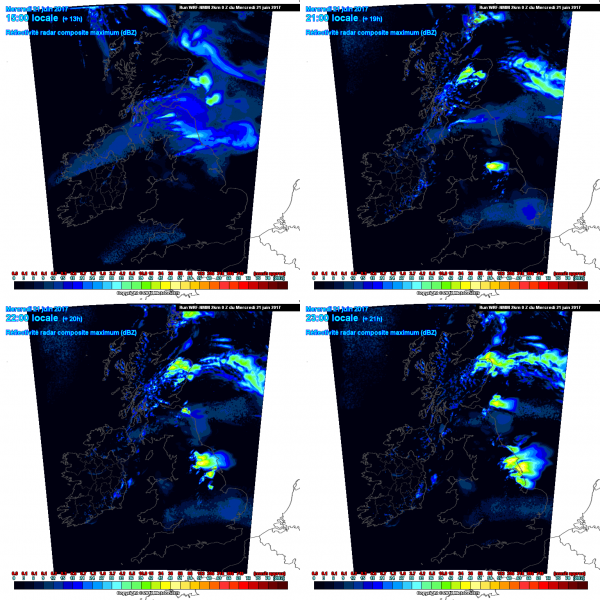
Still, the main question remains storm initiation and coverage. A strong capping inversion will be in place across most of CNTRL-S UK, hindering widespread storm initiation. Any storm initiation is likely to be limited, while some models still indicate no initiation at all, but confidence is quite good that some thunderstorms will initiate. Where storm initiation does occur, any thunderstorm that forms will have a good chance of becoming severe. High instability and the very strongly sheared environment will be very favourable for supercells.
Simulated radar reflectivity over the UK late this afternoon (WRF model guidance). Map: Meteociel.fr
Any storm that develops will have potential for large and even very large hail (>5 cm) and severe straight line winds. Strong low-level shear and veering vertical wind profile in the lowest kilometer significantly elevate tornado threat, in particular in the zone of increased low level shear.
We will be monitoring the situation and providing updates.


