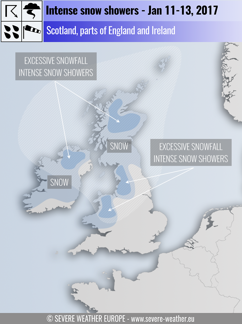
Parts of the British Isles and Ireland are expecting the first significant snowfall of the season. Intense snow showers and locally excessive snowfall (blizzard) across parts of British Isles through the next 3 days. Combined with gale to storm force winds at higher elevations across Scotland, the thickness of snow cover is expected to be irregular with local snow drifts. Snow blizzard conditions are expected locally at times.
As the cold blast of arctic airmass pushes over the British Isles, snow showers will begin over the higher terrain in NW Scotland.
During Wednesday, Jan 11th evening, as the cold air sinks south some snow showers seem possible in Northern England, NW Ireland as well.
On Thursday, Jan 12th the snow showers will begin pushing into central Scotland even at lower levels during the early hours of Thursday and could be heavy at times and locally persistent. NW Cumbria, North Yorkshire may also see a covering of snow before “rush hour”. By mid Thursday, northern Ireland will likely experience snow showers at lower levels while southern Ireland above 200 m could see some snow accumulation. By early afternoon snow showers, persistent at times, will push into Cumbria, West Midlands, much of Wales (especially over higher terrain) and N- NW exposed coastal areas in England & Scotland. Probably 5-10cm can be expected in these areas during Thursday with 10-15cm over higher elevations until the evening.
Despite still being 2 days out, on Friday Jan 13th it appears that N-NE Scotland is set for strong gale force winds over exposed coastal areas during the early hours (peak gusts could reach up to 120 km/h) and combined with very cold -10 °C air aloft, a decent period of snow fall over a 12 hour period late Thursday into Friday can be expected. Locally some excessive snowfall accumulation (20-50 cm) seems possible over the Cairngorms, Inverness and possibly as far east as Aberdeen, but lower amounts there. During Friday, the NW exposed coastal areas in Scotland, Ireland & Wales will see some showers working their way inland to fall as snow above 150-200 m above sea level.
White shaded areas will be experiencing strong to occasionally severe winds and therefore show showers will bring blizzard conditions and very low windchills at times!
We are closely monitoring the evolution and will have more updates in the next day or so. Forecast was done with our partners EU Storm Map!
Below is the wind forecast animation for the next 5 days, revealing several windy days across the British Isles, North Sea and SW Norway:
https://www.facebook.com/severeweatherEU/videos/1936124526610639/
Very low temperatures expected on Friday the 13th in the northern part of UK:
