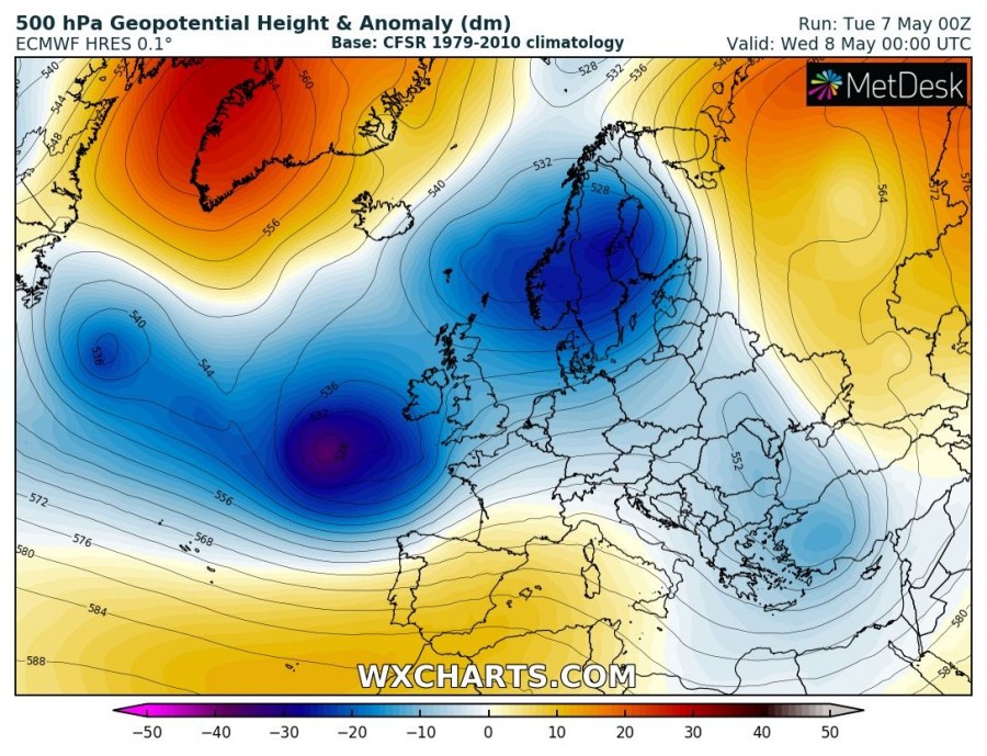
Our continent will continue experiencing a dynamic pattern through early/mid-May as a deep trough dominates Europe through these first days of the new week. Rainy periods are expected for some areas. A strong ridge develops over WSW Europe over the weekend and again establishes a cold pattern for central Europe and partly also the Mediterranean. Warm spring weather is postponed for at least another week.
Tuesday, May 7th
The large deep trough over Europe weakens with its southern edge cutting off over the SE Balkan peninsula. An associated cold front advances further NE and affects far ESE Europe. A new deep trough pushes from the N Atlantic into the Bay of Biscay with an intense surface cyclone, while an upper ridge builds up over Iberia. A large part of Europe is affected by strong Arctic maritime airmass advection, reaching E Mediterranean as well. The warmth continues over Iberia.
Wednesday, May 8th
A deep trough is located over N Europe while the N Atlantic trough pushes into W Europe with an intense cyclone across the Bay of Biscay into France. A short-wave trough over Balkan peninsula moves into SE Europe and the ridge over Iberia expands into the W Mediterranean. The deep cyclone brings a return of warmth into the W Mediterranean and France while cold continues over north-central Europe, the Balkan peninsula and the E Mediterranean.
Thursday, May 9th
A large trough develops over west-central Europe with frontal system bringing unsettled weather conditions. Short-wave over SE Europe weakens while moving further east. Ridge over SW Europe weakens. Cold weather finally weakening over all regions while significantly warmer weather spreads over the Mediterranean. Very cold weather develops over N Atlantic and Iceland.
Friday, May 10th
A long-wave trough over west-central Europe continues into ESE Europe and Balkan peninsula, while upper ridge over SW Europe strengthens. Warmth continues over Iberia, while very cold weather is expected over Iceland and the Middle East.
Saturday, May 11th
Similar pattern as a day before, large trough remains over north, west and SE Europe while ridge continues strengthening over SW Europe. Ridge also strengthens over N Russia into Fennoscandia with significant warming. Very cold over N Atlantic and Iceland continues, as does warmth over Iberia.
Sunday, May 12th
While trough is weakening over Europe, the upper ridge from SW Europe expands north into N Atlantic and W Europe. On its eastern flank, a new upper trough is pushed meridionally into the N Mediterranean. Very cold weather from N Atlantic spreads into W Europe while much warmer / hot weather continues over SW Iberia. Unusually very warm weather also continues over Fennoscandia and NW Russia.
Monday, May 13th
Strong upper ridge now expanding over WSW Europe and N Atlantic while trough over the Mediterranean deepens and strengthens. Strong ridge remains over N Russia and Scandinavia. Blocked N Atlantic and W Europe establishes meridional flow again towards central Europe, cold advection pushes towards the Mediterranean. Extreme warmth over Fennoscandia and NW Russia continue.
Stay tuned for more details on the separate systems throughout this week.


