The first substantial severe risk of 2019 for the US is taking shape this coming Saturday. Large hail, severe straight line winds and also tornadoes will be possible as storms develop along the sharp cold front. The front is associated with the deep cyclone moving across the Great Plains and Midwest.
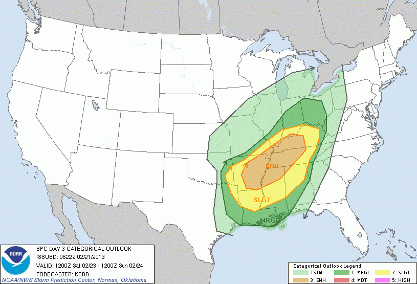
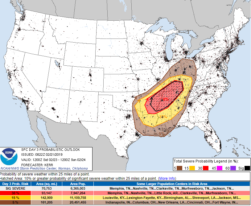
The Storm Prediction Center (SPC) has issued an ENH (enhanced) risk for severe storms, with 30% hatched area (= 10% or greater probability of severe weather) across the eastern Arkansas, northern Mississippi into western Kentucky and Tennessee. A SLGT risk has been placed surrounding the ENH risk area.
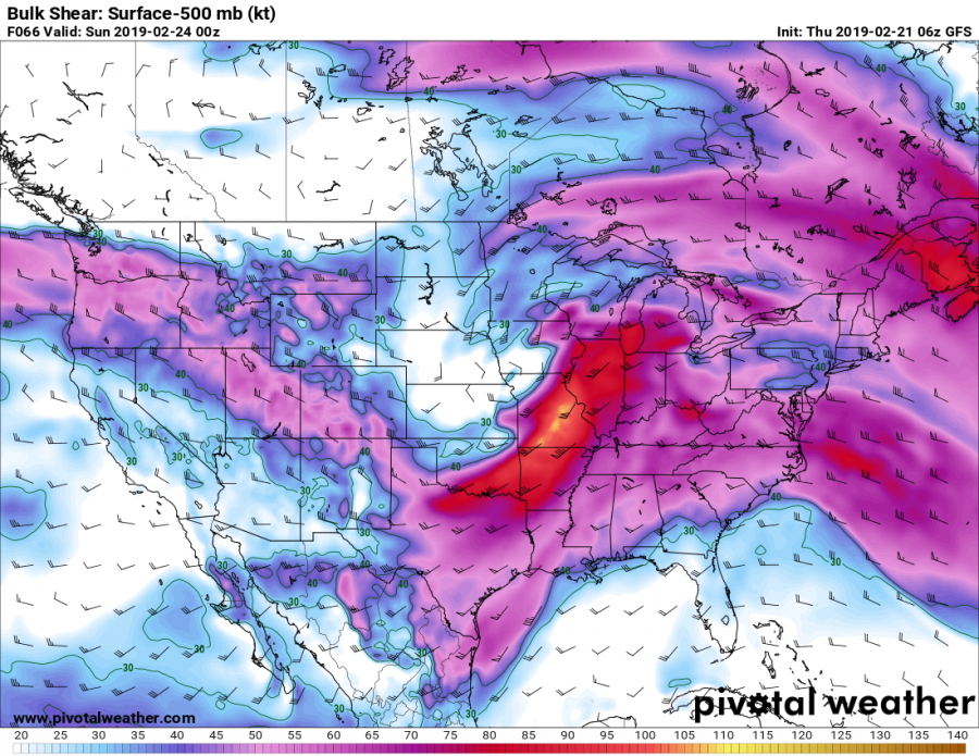
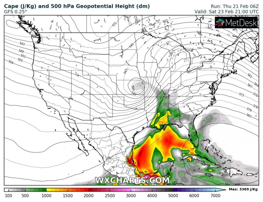
Very extreme deep-layer shear will be available, likely 80-100 knots in the 0-6 km layer! Despite the rather low instability (500-1000 J/kg of MLCAPE), severe storms will develop and organize with time.
The additional danger with these storms will be their fast motion, as due to a very strong winds aloft (jet stream), storm cells will be moving extremely fast. Storm speeds could be up to or exceeding 60 mph (100 km/h), resulting it a very dangerous situation if tornadoes do occur in the populated areas.
Here is the official outlook from the SPC:
Day 3 Convective Outlook
NWS Storm Prediction Center Norman OK
0222 AM CST Thu Feb 21 2019Valid 231200Z – 241200Z
…THERE IS AN ENHANCED RISK OF SEVERE THUNDERSTORMS SATURDAY THROUGH SATURDAY EVENING ACROSS PARTS OF CENTRAL/EASTERN ARKANSAS… THE MISSOURI BOOTHEEL… WESTERN/CENTRAL KENTUCKY… WESTERN/MIDDLE TENNESSEE… NORTHERN MISSISSIPPI AND NORTHWESTERN ALABAMA…
…SUMMARY…
An organized cluster of severe thunderstorms may evolve Saturday in a corridor across the Ozark Plateau through the lower Ohio Valley, with additional severe storms possible across the lower Mississippi into Tennessee Valleys. Considerable wind damage may accompany these storms along with the risk for tornadoes, some of which could be strong.
…Discussion…
In phase with the subtropical westerlies, a vigorous short wave impulse of mid-latitude Pacific origins is forecast to accelerate northeast of the southern Plains through the Great Lakes region during this period. Strong cyclogenesis may already be underway by 12Z Saturday near the Texas/Oklahoma Panhandle vicinity, and models continue to indicate that the rapid evolution of a broad and deep cyclone will proceed northeastward into the Great Lakes region by the end of the period.
This likely will include the intensification of a cyclonic mid-level jet, including speeds in excess of 100 kt at 500 mb, across the southern Plains Red River Valley, through the middle Mississippi and Ohio Valleys. Across the evolving warm sector, models indicate that south/southwesterly winds will strengthen to 50-70+ kt through the 850-700 mb layer.
Although the warm frontal zone probably will surge north of the Ohio River, and into/through the lower Great Lakes region by late Saturday evening, an initial position roughly along the Ohio River west-southwestward into the Ozark Plateau may provide the main focus for severe thunderstorm potential. Early period convection, associated with weak elevated destabilization above the front, may inhibit, or at least slow, boundary-layer destabilization to the north, while leaving a remnant surface boundary.
In association with the onset of stronger surface pressure falls, surface dew points are expected to increase through the lower/mid 60s along and south of this boundary. Coupled with strengthening large-scale ascent, this is expected to contribute at least weak boundary-layer destabilization supportive of an evolving organized mesoscale convective system. CAPE on the order of 500+ J/kg appears possible. Given the strength of the environmental wind fields (and shear) within the convective layer, the convective system may be accompanied by considerable potential for strong and damaging wind gusts.
It appears that this may initiate over parts of central and eastern Arkansas by midday, before progressing east-northeastward through the lower Ohio Valley by Saturday evening. A few tornadoes, some strong, are also possible, particularly with discrete supercells which may form near/just ahead of mainly the southern flank of the evolving system.
More discrete storms, including supercells, may eventually develop as far south as the lower Mississippi Valley through portions of the southern Appalachians by late Saturday night.
..Kerr.. 02/21/2019


