The latest round of Winter 2023/2024 forecasts confirms a strong presence of the El Niño event in the Weather patterns. We expect a pronounced change in the jet stream patterns compared to last year. A colder trend is still indicated for the central and eastern United States, while Canada and Europe are mostly warmer than normal.
The global weather system is complex, with many large-scale and small-scale climate influencers. A large El Niño event will be the main culprit behind the 2023/2024 Winter across the Northern Hemisphere.
First, we will quickly go over the El Niño regions, analyze the latest ocean anomalies, and look at the past El Niño events and the weather patterns in those Winters. We will compare that data with long-range forecasts to see what the latest round of Winter simulations show.
ENSO AND WEATHER ANOMALIES
ENSO is short for “El Niño Southern Oscillation.” This region of the equatorial Pacific Ocean changes between warm and cold phases. Typically, there is a phase change around every 1-3 years.
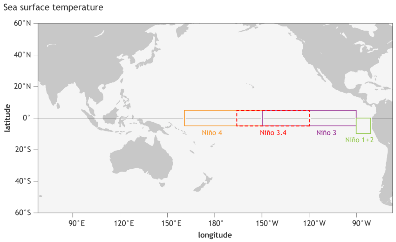
We are currently entering a warm phase called El Niño. Below, you can see the main areas of the ENSO in the Pacific Ocean. From these zones, we also calculate the ocean anomalies and the ENSO strength.
ENSO significantly influences tropical rainfall, pressure patterns, and the complex ocean and atmosphere exchange. These changes affect circulation over the rest of the world with some time delay.
The following image below from NOAA Climate shows the typical circulation during an El Niño event.
In El Niño, rising air in the eastern Pacific causes more storms and precipitation and lowers the pressure over that region. At the same time, the air is descending in the western Pacific, causing stable weather and high-pressure conditions.
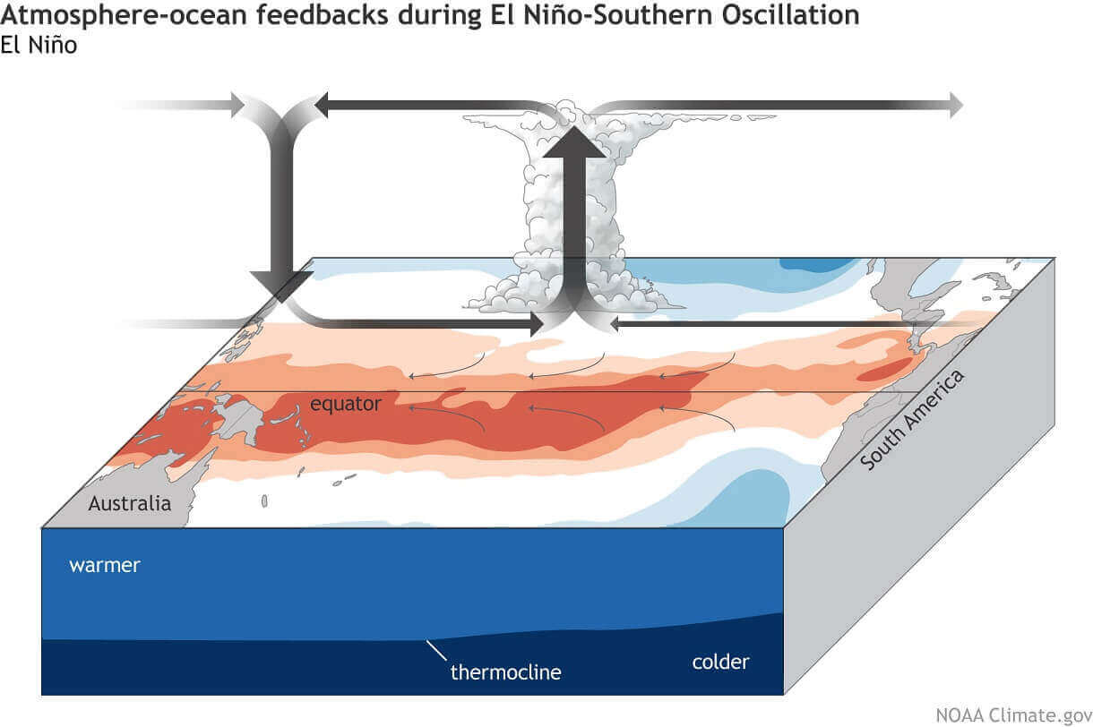
This way, El Niño significantly impacts the tropical rainfall and pressure patterns and thus impacts the ocean-atmosphere feedback system. Through this ocean-atmosphere system, the ENSO influence then spreads globally.
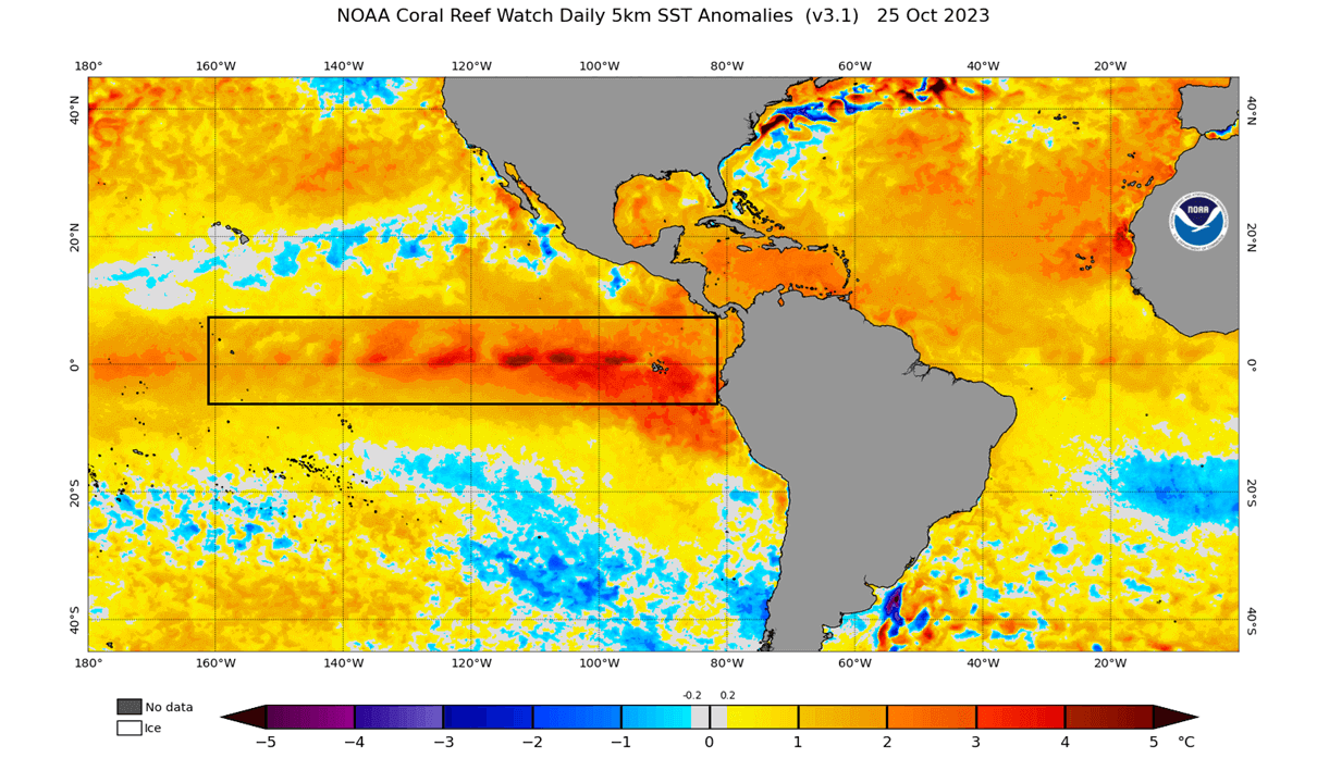
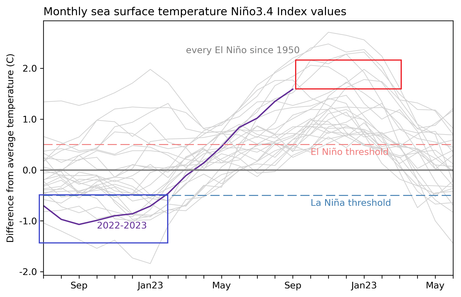
Below is the latest surface analysis of the tropical Pacific Ocean. We can see the marked warm anomalies of the El Niño event, reaching over 4 degrees Celsius above normal. In contrast, this time last year, the cold ENSO event had peak anomalies 3 to 4 degrees below normal. So quite a change compared to last year.
El Niño forms during weak trade winds, which can tell us much about global circulation. This way, we can use these ocean anomalies as an “indicator” to know the current state of the global climate system.
Below, you can see the last two years of ocean anomalies in the ENSO region. You can see the third La Niña event in 2022 and the fast rise in ocean temperatures that has led to an active El Niño event. The red box shows the projected peak values of the El Niño event over the Winter 2023/2024.
We produced a video showing the ocean anomalies from late Winter to Summer to better understand the ENSO development and ocean dynamics.
The cold La Niña anomalies quickly broke down over the Winter, with warm El Niño anomalies emerging in early Spring. Notice the motion of the anomalies on the ocean surface, driven by the trade winds.
The IRI multi-model predictions show the consensus that El Niño will peak around +2 degrees above normal. That is considered a strong event. But the forecasts also agree that the El Niño will start to dissolve somewhere towards Summer 2024.

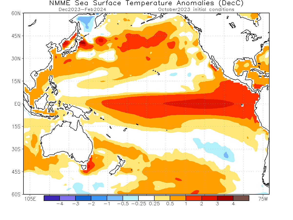
Looking at the Winter 2023/24 ocean forecast below from NMME, you can see a strong El Niño event expanding across the entire tropical Pacific. An event of this magnitude is strong enough to have a profound atmospheric response worldwide. A stronger impact is expected during the upcoming Winter of the Northern Hemisphere.
But we can now go away from the ocean and look into the atmosphere, for some of the weather changes from the El Niño.
WINTER AND THE JET STREAM
Typically, the first influence of these ocean anomalies can be seen in the changing jet stream. The jet stream is a large and powerful stream of air (wind) at around 8-11km (5-7mi) altitude.
It flows from west to east around the entire Northern Hemisphere, interacting with pressure systems and shaping our weather on the surface.
The jet stream is a very important piece of the Winter story. It is one of the main ways El Niño can change the weather patterns more directly, especially over North America.
During the El Niño winter season, there is typically a strong and persistent low-pressure area in the North Pacific. That pushes the polar jet stream further north, bringing warmer-than-normal temperatures to the northern United States and western Canada.
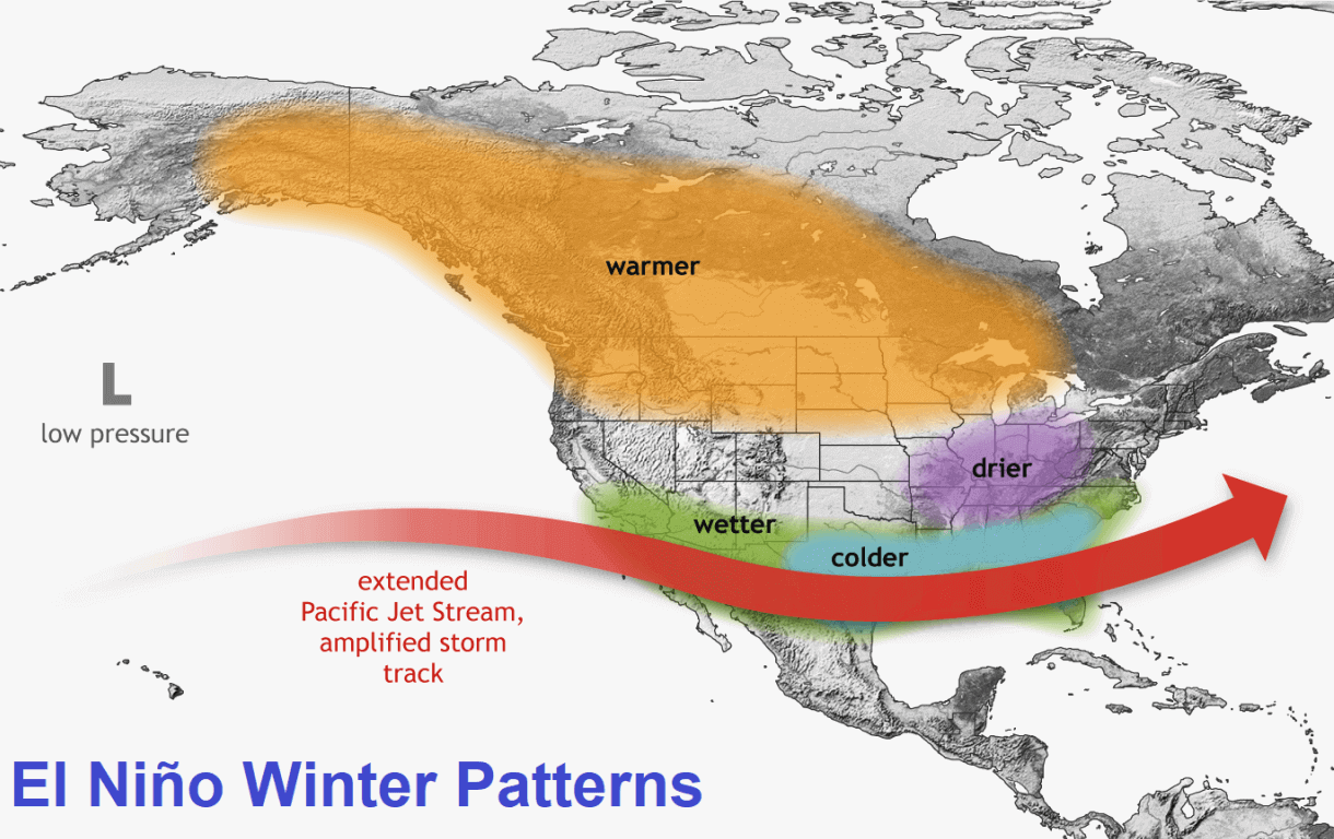
But the southerly Pacific jet stream is extended and amplified during an El Niño, bringing low pressure and storms with lots of precipitation and cooler weather to the southern United States.
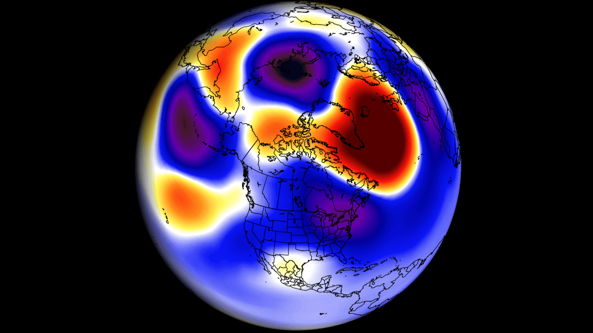
You can see exactly that in the jet stream anomaly forecast below for January 2024. It shows the typical strong subtropical jet stream over the southern United States (red). Image by meteorologist Ben Noll.
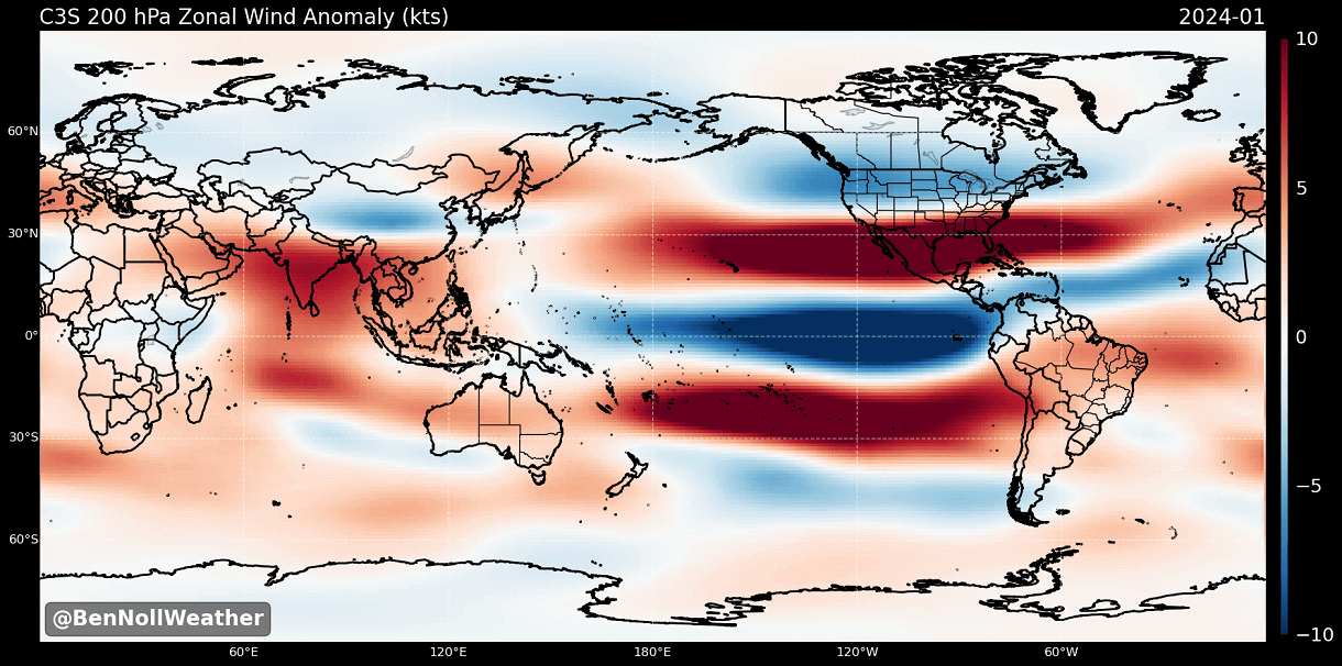
A stronger subtropical jet supports moisture transport into the southern United States, thus increasing the odds for snowfall in the southern states and across the Mid-Atlantic. That is if there is enough cold air available.
A pattern like this would bring colder temperatures and more snowfall across the central and parts of the southern United States, especially across the Mid-Atlantic and the northeastern United States.
The image below shows the average winter pressure pattern for past El Niño winters during the satellite era. You can see the strong low-pressure area in the North Pacific, typical for an El Niño. A high-pressure zone is focused over Canada, with a low-pressure storm track and precipitation spanning the southern United States.
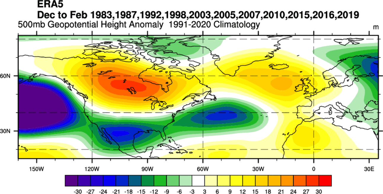
Another high-pressure area is over southern Greenland and northwestern Europe. This helps to produce a more northerly flow over central and northern Europe but varies greatly as other influences come into play there.
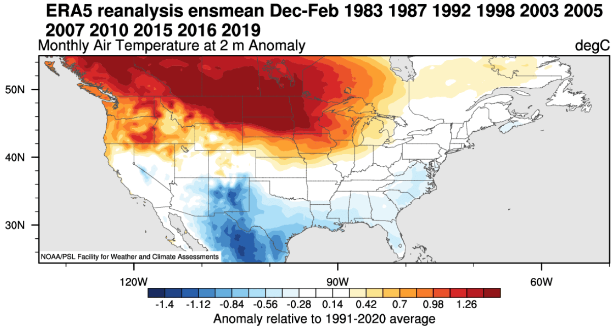
Looking at the temperature anomalies in an average El Niño winter, you can see colder temperatures in the southern half of the United States and parts of the eastern United States. The country is (relatively) warmer in the northern, spreading warmth into southern Canada.
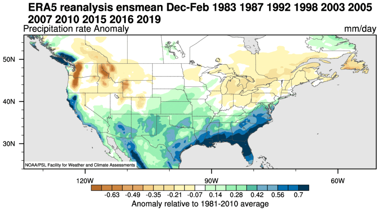
Precipitation-wise, an average El Niño winter brings more precipitation to the southern half of the United States, especially in the Southeast. However, drier winter conditions prevail in the northwestern United States and around the Great Lakes.
El Niño also changes the Winter snowfall patterns, as seen in the image below. Some of the areas with more snowfall during an El Niño include New England, parts of the mid-Atlantic, parts of the mid-south, the southeastern United States, as well as the plains, four corners, and southwest. Image by meteorologist Ben Noll.
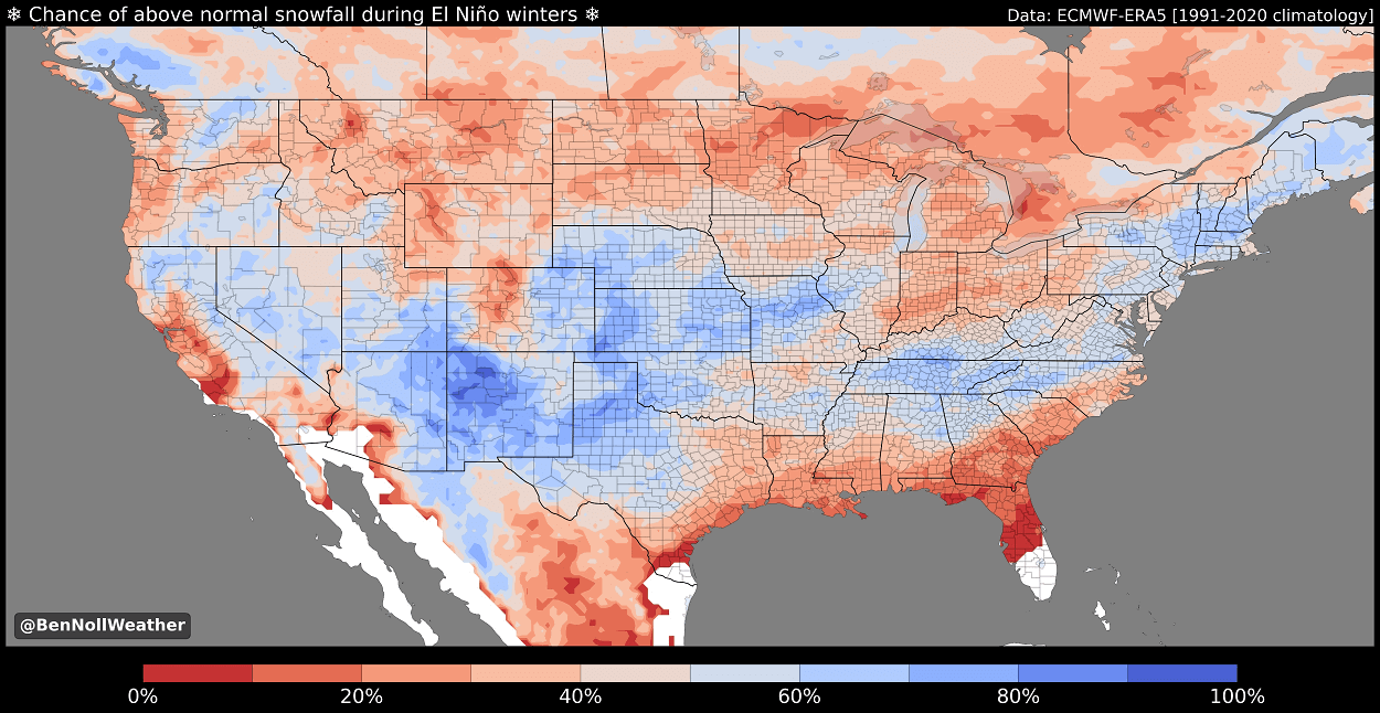
That is mainly due to low-pressure systems trailing across the southern United States. More moisture increases the chances of snowfall in the southern half if cooler air is available. But a lot depends on the availability of the cold air to the north.
Less snowfall is usually seen across the deep southern United States, Ohio Valley, Midwest, northern Plains, northern Rockies, and Pacific Northwest.
After passing Canada and the United States, the jet stream moves into the North Atlantic, where it can take different paths toward Europe.
ENSO EUROPE DEVELOPMENT
The ENSO effects are much less direct in Europe than in North America because other factors are also involved, like the existing North Atlantic pressure pattern. We focus more on North America to track direct (and more predictable) weather pattern changes.
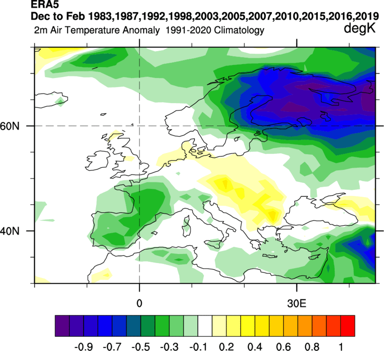
But we still tried to find any historical connections of ENSO to Europe. For this reason, we produced two graphics below for temperature and precipitation based on combined data from past El Niño Winters.
Looking at temperature first, we can see an interesting cold signal over northern Europe. There is also a cooler signal over western Europe, while the temperatures are higher than normal around central parts.
The El Niño Winter precipitation composite shows more precipitation in northwestern Scandinavia and parts of central and southeastern Europe. Western Europe is usually drier in an El Niño winter.
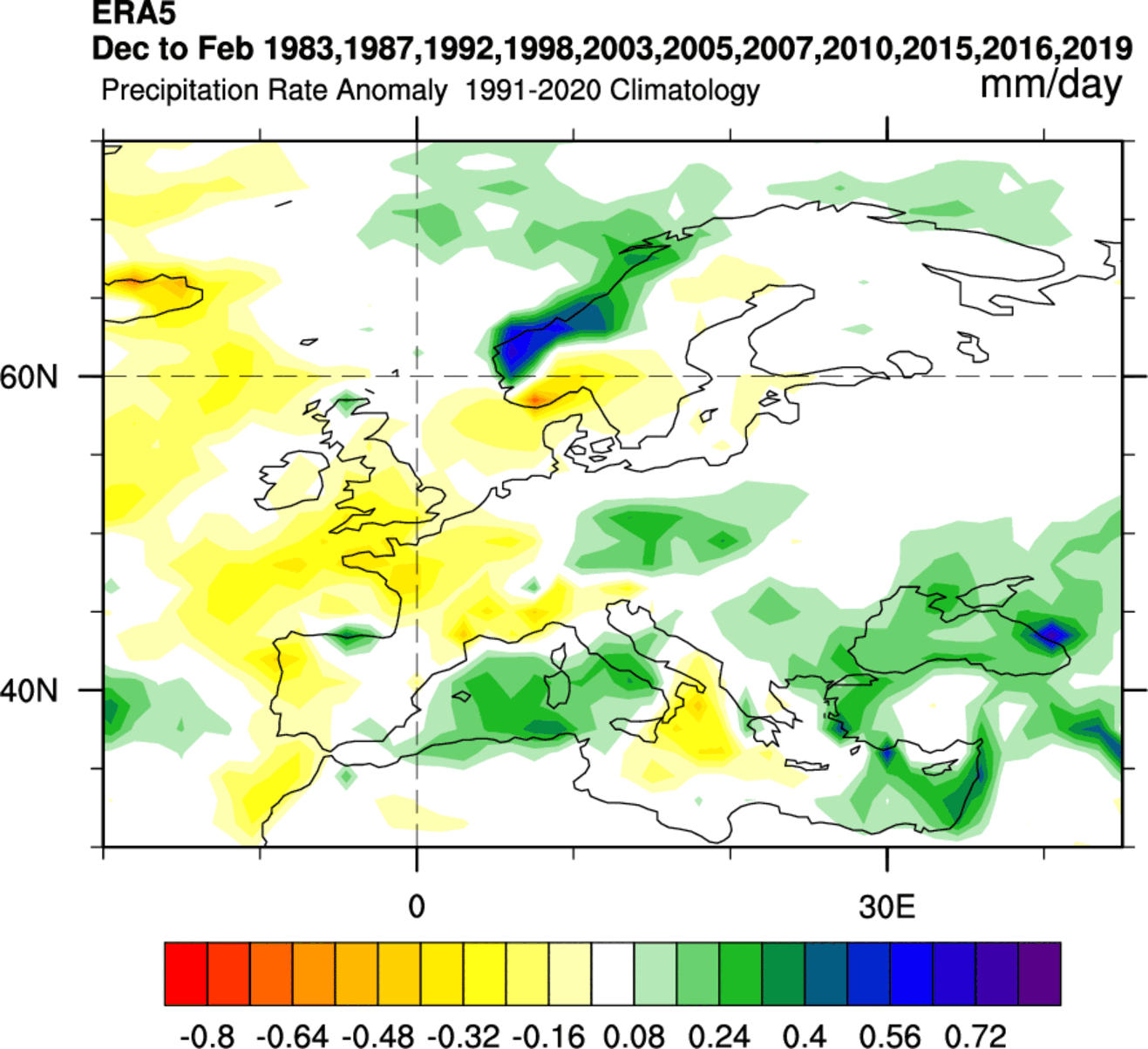
The highest snowfall potential looks to be over and around the Alpine region and towards the higher elevations of southeastern Europe. And, of course, over northwestern parts of Scandinavia.
Knowing what the main driver will be this Winter over the Northern Hemisphere, we can finally look at how the latest models calculate all the oceanic and atmospheric factors.
WINTER 2023/2024 LATEST FORECAST
We will look at the global long-range models and their early hints for Winter 2023/2024 from the latest available data.
We focused on the three seasonal models. The ECMWF from Europe, the CanSIPS from Canada, and the NMME from a joint project by the United States and Canada. Graphics are from the Copernicus Climate project, CPC/NCEP, and Tropical Tidbits.
All these forecasts are an average picture over three meteorological winter months (December-January-February) and show the general prevailing weather patterns.
Even if the models were 100% accurate, it does not mean such weather conditions would last for three months straight. It only suggests how the weather patterns might look most of the time.
ECMWF WINTER FORECAST
The ECMWF model is often referred to as the most reliable model. But no long-range/seasonal forecast can ever be called “reliable“. That is because we are only looking at trends and how the weather patterns might evolve on a large scale over a longer period of time.
The winter pressure pattern forecast from ECMWF below shows an underlying El Niño weather pattern. We have a high-pressure zone over Canada and Greenland and a belt of low-pressure anomalies across the southern United States and the North Atlantic.
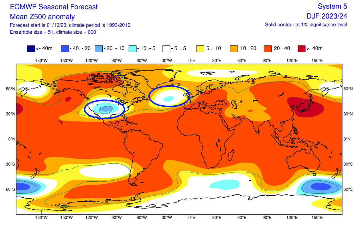
The interesting anomaly is the low-pressure zone over the United States. It is not of a typical El Niño Winter scale, but it does fit into the overall idea of the Northern Hemisphere El Niño pattern.
Looking at the surface temperature forecast over Europe, notice the surface temperatures are warmer than normal across the entire continent. This indicates a strong westerly to southerly flow over the Winter. But, even in the warmest winters, there are still individual pattern breaks that can create an occasional cold air drop from the north.
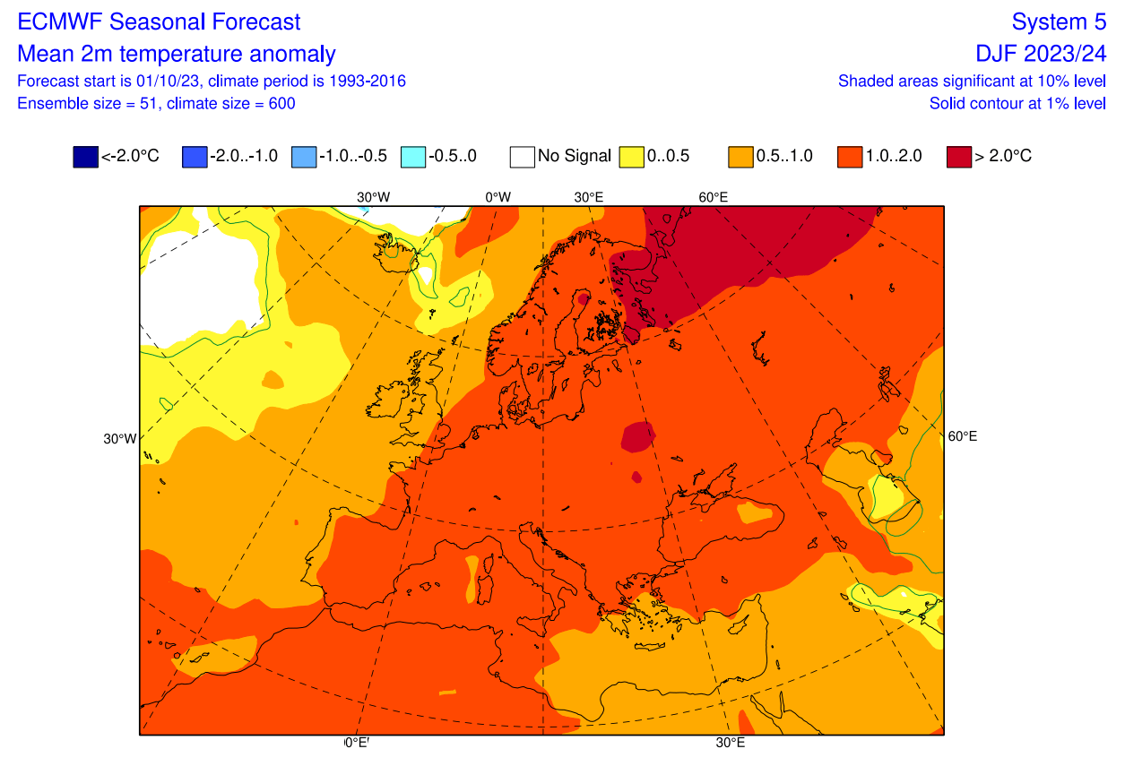
Over North America, the ECMWF forecast shows much above-average temperatures over most of Canada. Warmer than normal temperatures are forecast over the northwestern and northern United States. But notice a cold air anomaly developing over the United States.
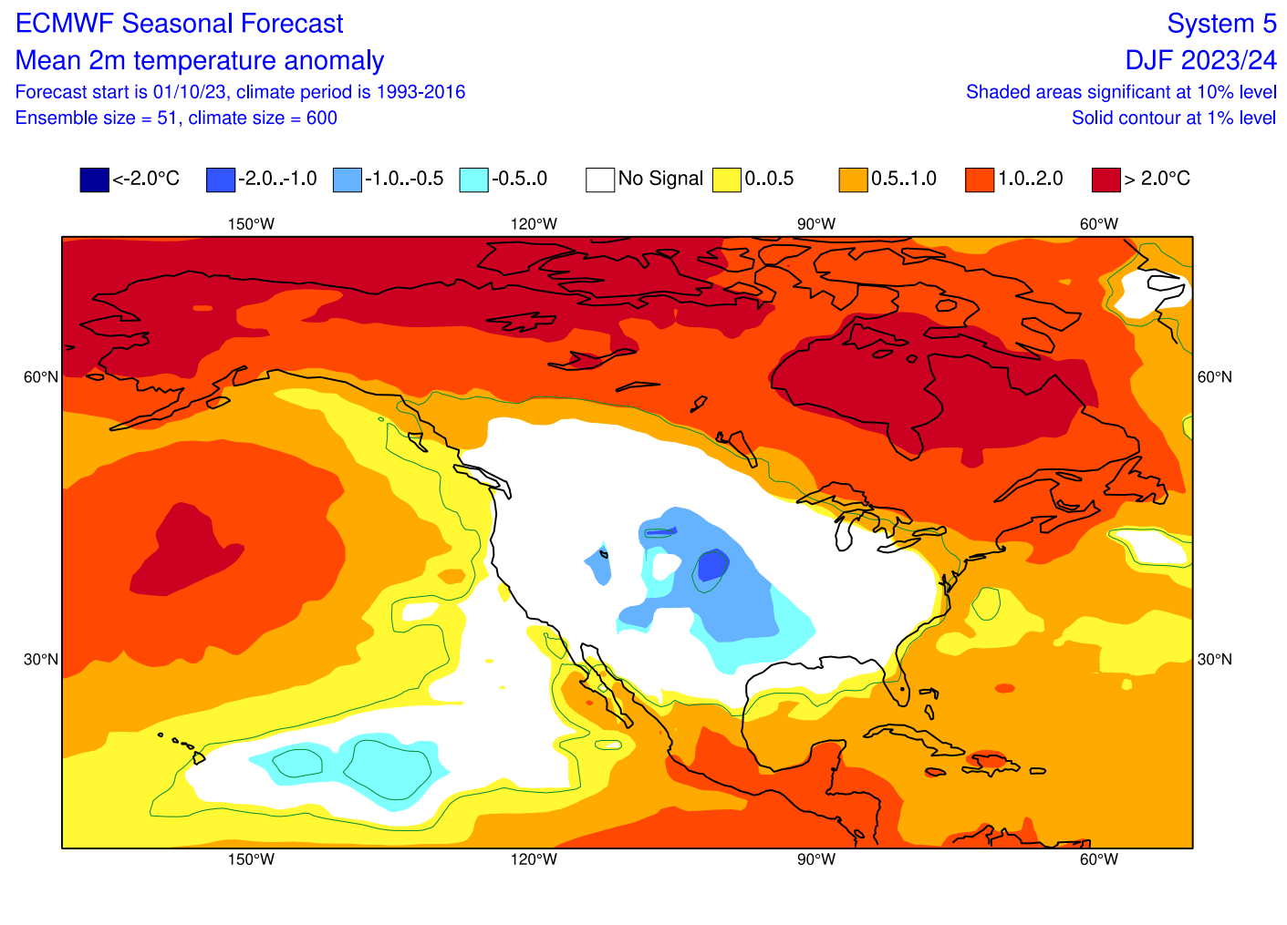
This cold anomaly is expected for an El Niño winter in the southern United States due to the amplified subtropical jet stream and more low-pressure systems passing the region. But this anomaly does seem more than just some typical El Niño response and reflects a broader circulation pattern.
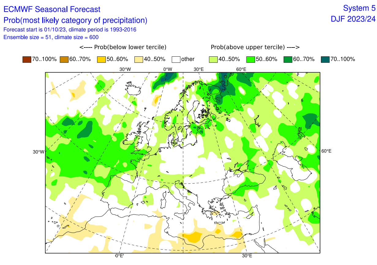
Looking at the precipitation forecast, we can see above-average precipitation forecast for most of Europe. This increases the snowfall potential mostly over the Alpine region and Scandinavia.
The precipitation anomaly forecast for North America shows an expected El Niño-type pattern over Canada and the United States. You can see drier conditions over the Pacific Northwest and wet in the Southeast.
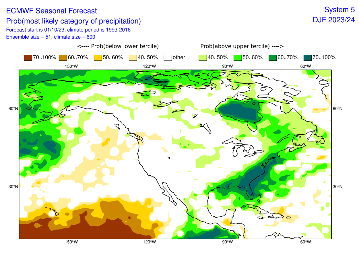
The strong subtropical jet stream of El Niño brings increased moisture and precipitation across the southern and eastern parts of the United States and the plains. Increased precipitation is also forecast across eastern Canada.
WINTER 2023/2024 ECMWF SNOWFALL FORECAST
We produced a special snowfall forecast from the ECMWF data provided by the Copernicus-EU project. It shows the average snowfall anomaly over a 3-month period (December-February).
Over Europe, we see mostly below-average snowfall, except over parts of Scandinavia and the Alpine region. This reflects a dominant westerly pattern, bringing more moisture and less cold from the North Atlantic.
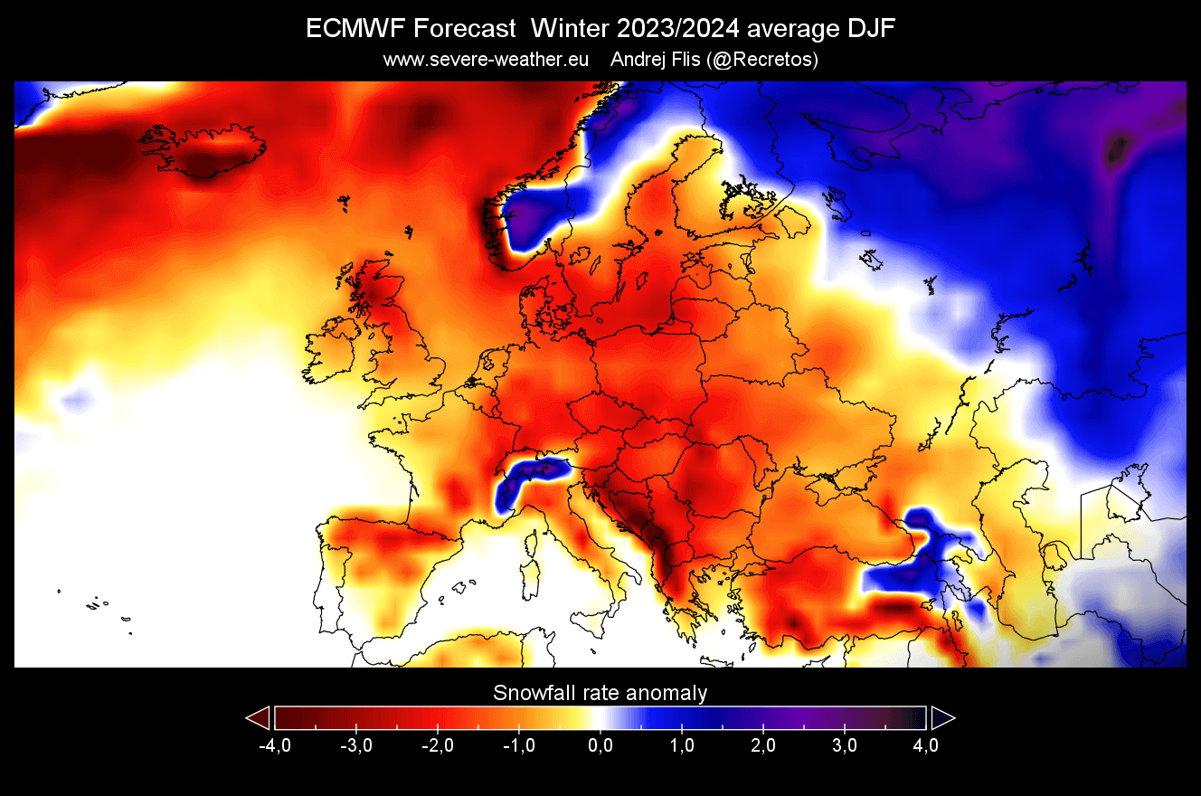
Over North America, we see a very interesting snowfall forecast. ECMWF suggests more snowfall than usual across much of the central Plains, northern Plains, the southern United States, and the upper Midwest. This is a strong snowfall forecast, which is, at the moment, more unique to the ECMWF model.
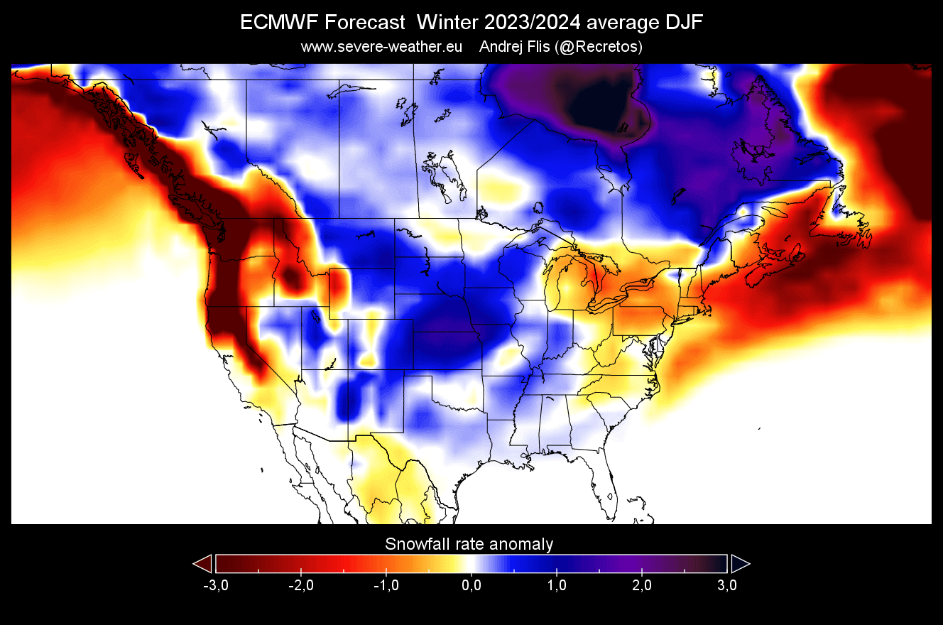
Looking at Canada, you can see increased snowfall across the southern and southeastern parts of the country, while less snowfall is forecast across the West North American coast.
Remember that this is a 3-month average, and the month-to-month snowfall potential can be very different. Especially going into the mid and late-winter season.
CANSIPS MODEL WINTER FORECAST
Our second model is the CanSIPS model from the Canadian met-office. The name stands for Canadian Seasonal and Interannual Prediction System (CanSIPS). It consists of two coupled atmosphere-ocean-land physical climate models.
This model shows an interesting El Niño pattern, which we have already seen in the historical analysis. A high-pressure zone sits over Canada and Greenland, with a low-pressure response over the United States, North Pacific, and Europe.
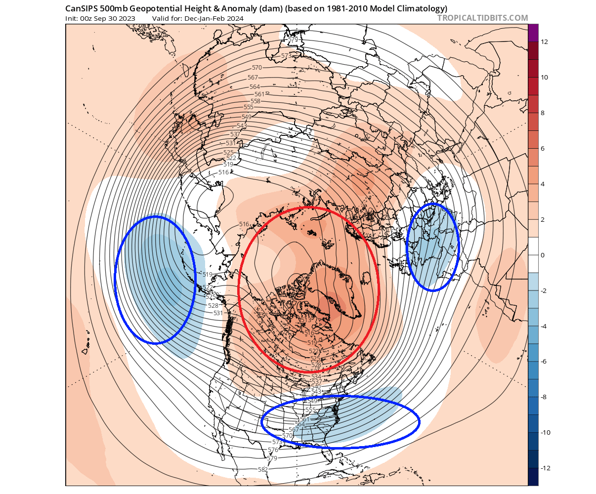
This is actually a strong blocking pattern, with a good mid to late-winter cold scenario potential across the central and eastern United States and parts of Europe.
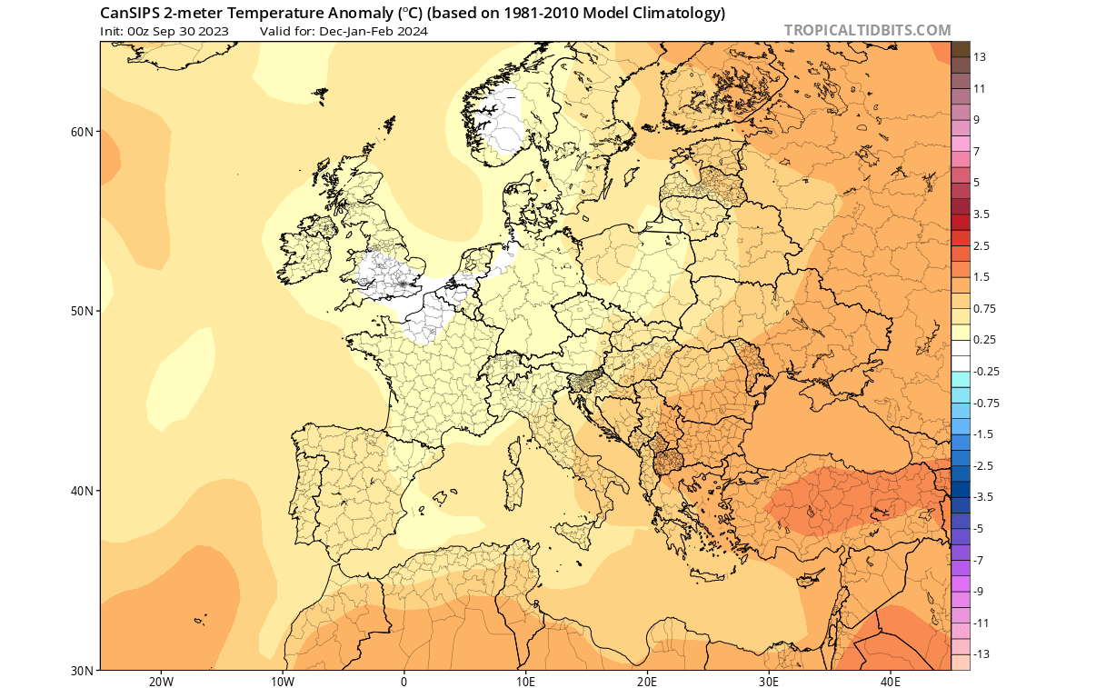
Looking closer at surface temperatures over Europe, we see the warm anomalies focused over much of the continent. A neutral anomaly zone is over the southern UK, and northern parts of Central Europe.
Over North America, the Cansips model has warmed up from the previous forecasts over the United States. Strong warm anomalies remain forecast over Canada. There is a neutral zone over the southeastern United States.
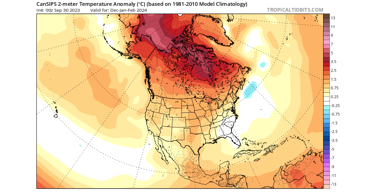
But the forecast above is a 3-month average for December to February. Below is the Cansips forecast for February 2024. You can see a much broader area of colder than normal temperatures, spanning much of the eastern United States. This would increase late Winter and early Spring snowfall potential across the eastern United States.
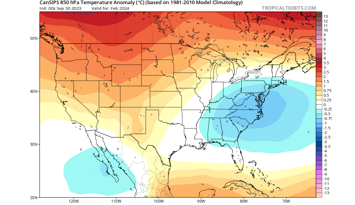
This shows that the Winter of 2023/2024 might be off to a slower start across the central and eastern United States, with a colder season in the second half. But, the models are still not in strong agreement about where and when exactly this colder part of the Winter will be in the United States.
Looking at precipitation, the Cansips forecast is similar to the ECMWF. The Canadian model shows more precipitation over much of central and southern Europe. Less precipitation is forecast for northern Europe.
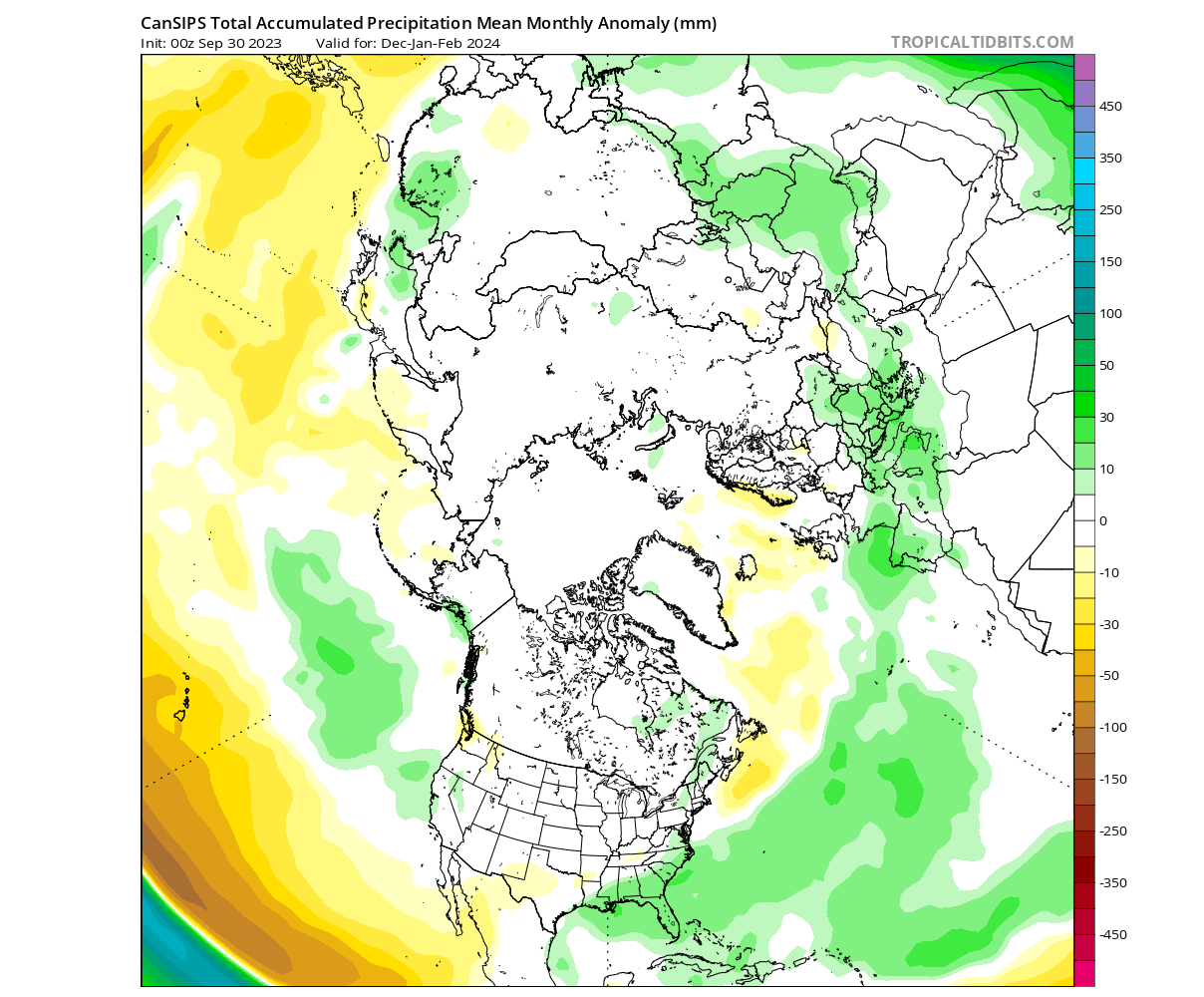
We can also see a very similar precipitation forecast over North America. Drier than normal conditions will prevail over the northwestern United States. At the same time, more precipitation is forecast for the southeastern and eastern United States.
This is close to the general idea of the ECMWF, with the subtropical jet stream bringing more moisture and precipitation to the southern and eastern parts of the United States.
NMME WINTER 2023/2024 FORECAST
In contrast to the more traditional models, we use the NMME model system. It stands for North American Multi-Model Ensemble (NMME). It combines several individual models to show an average picture from different solutions.
This system can have high confidence as it averages several different models. But, the drawback is that the forecast image can get heavily diluted at longer ranges. That is due to the strong variations in the forecast from very different models in the mix.
The North American surface forecast shows a similar pattern as other forecasts. Warmer anomalies over Canada and the northwestern United States and around the Great Lakes. At the same time, a neutral zone is over the central and eastern United States.
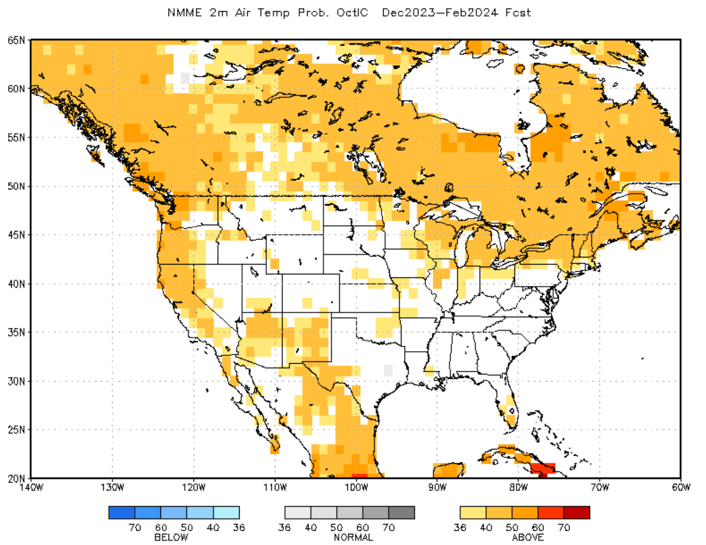
This “lack” of a strong warm winter signal over the Plains of the United States and the eastern United States can indicate some cold events in two ways: It can be seen as a more average Winter, or it can mean that strong cold events negate the strong warm periods.
The precipitation anomaly forecast for North America shows a typical El Niño pattern. More precipitation across the southern and eastern United States, while drier conditions prevail over the Pacific Northwest.
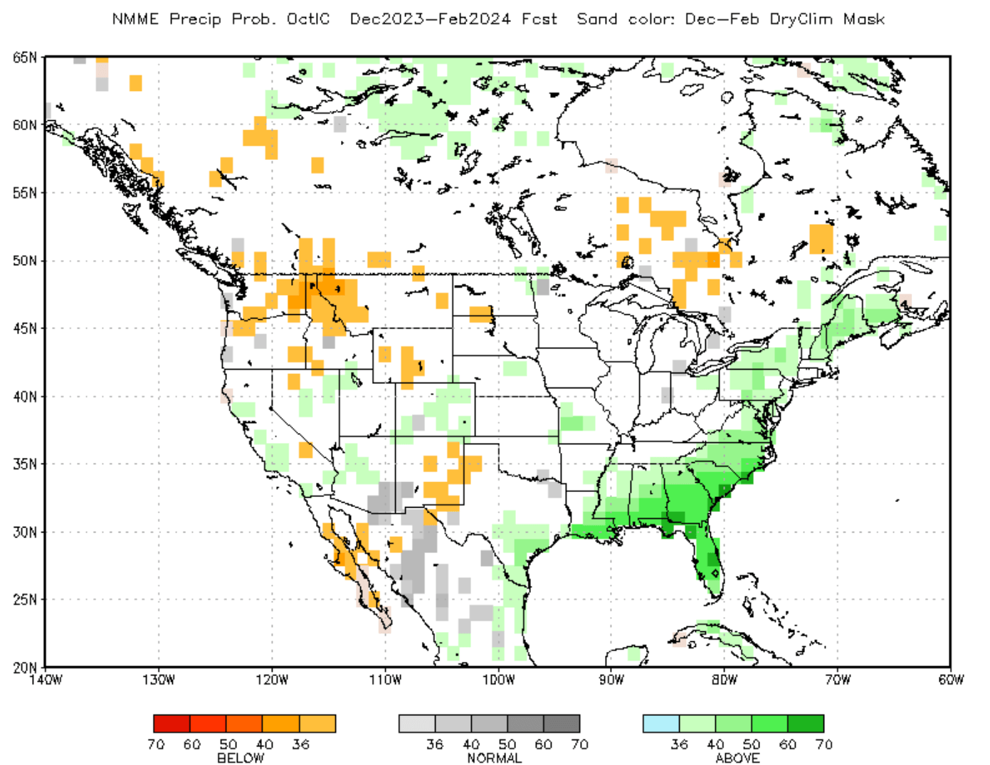
We must remember that most strong weather dynamics happen between the cold and warm anomalies, including snowfall. NMME has no snowfall graphics, so we usually look for increased snowfall potential where cold temperatures overlap with more precipitation.
In this case, that would be around the central and northern Plains and towards the northeastern United States.
WINTER 2023/2024 UPDATE FORECAST SUMMARY
Reading images and descriptions can be somewhat confusing. To simplify everything, here is what the latest Winter season 2023/2024 forecast has to offer in a short version:
Europe is expected to have warmer-than-average temperatures over most of the western and central parts of the continent. Colder temperatures will be more defined in the northern and northeastern parts of the continent.
This means that the main circulation mode over Europe will be westerly, meaning a warmer, moist flow from the North Atlantic into Europe. The potential snowfall scenarios are limited to higher elevations and individual cold events, which cannot be resolved in a 3-month average.
The models still don’t agree on the pressure patterns in the North Atlantic. The main key is the positioning and strength of a potential high-pressure zone over Iceland/Greenland relative to the North American pattern.
Precipitation-wise, normal to increased precipitation is expected over much of Europe. The snowfall forecast shows less snowfall over Europe, despite more precipitation, except for the higher elevations.
North American winter forecast looks increasingly likely to be a classical El Niño-type winter. Most of Canada and the northern United States will be warmer than normal under a weaker polar jet stream.
With the stronger subtropical jet stream from El Niño, normal to cooler temperatures are expected across the southern and eastern parts of the United States.
The subtropical jet stream also brings a lot of moisture, so more precipitation is forecast across much of the southeastern and eastern United States. Less precipitation is forecast for the Pacific Northwest.
Based on the latest round of Winter forecasts, the emerging trends point to a slow start to Winter, with cold air anomalies expanding across the central and eastern United States in the mid to late Winter season.
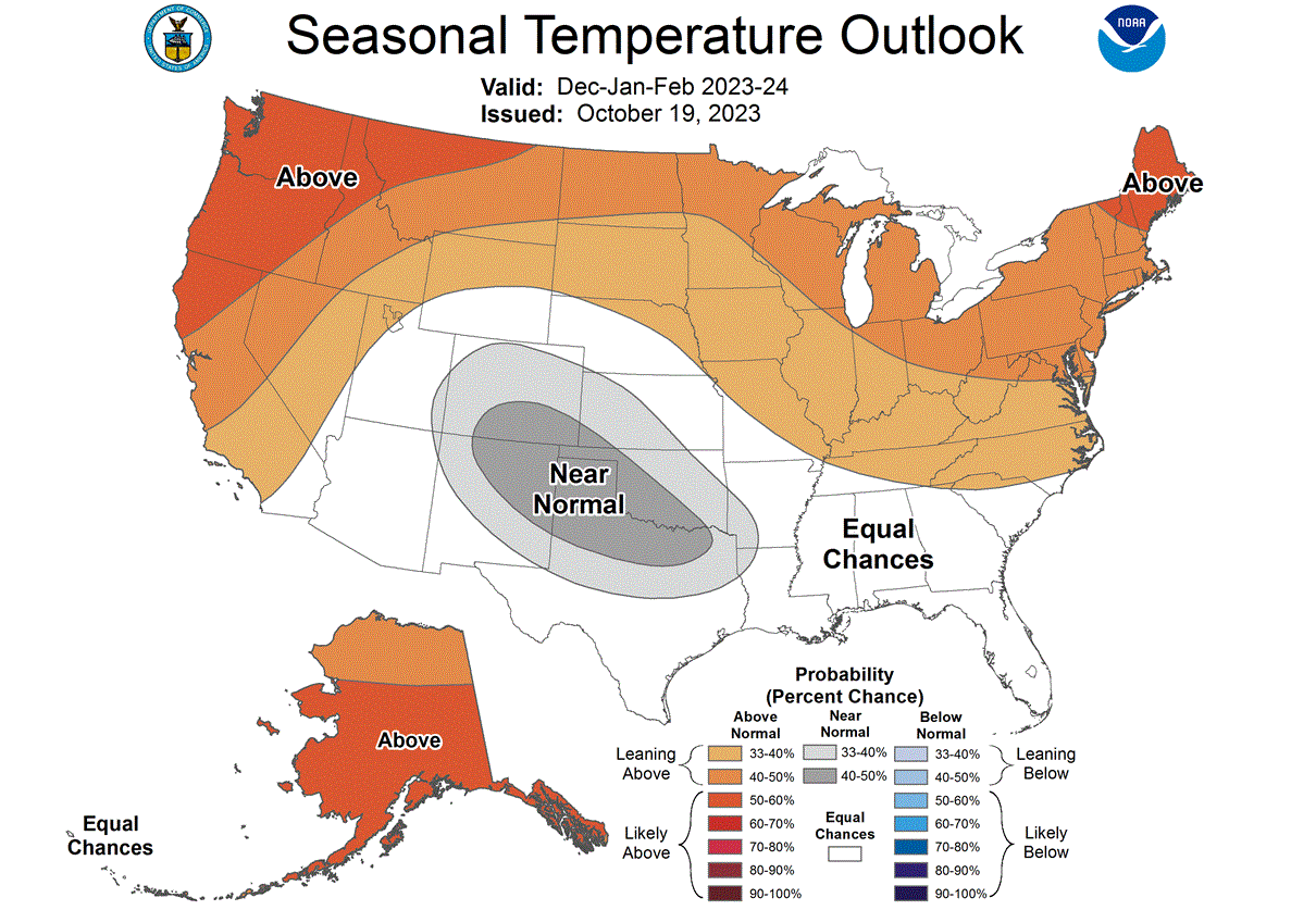
Below is NOAA’s latest Winter 2023/2024 temperature forecast for the United States. It shows the temperature probability, with warmer chances in the northern United States. The southern half of the country is in a neutral zone. That is also where the highest potential is to see lower-than-normal temperatures in the middle and later part of Winter.
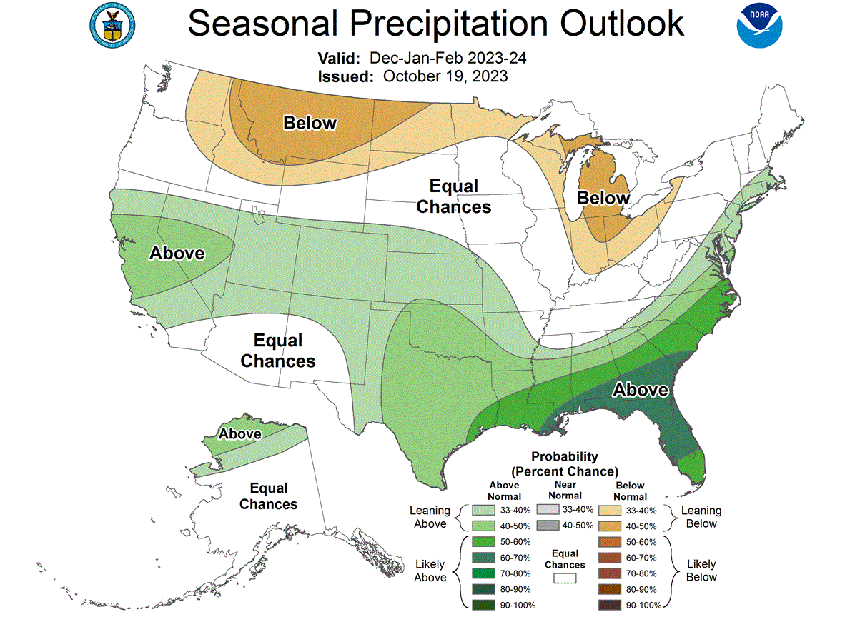
The official precipitation forecast is also quite similar to the models above. We see an equal-to-higher probability for more precipitation (and snowfall) over the southern and eastern parts of the United States. Less precipitation is expected across the northern United States.
We will keep you updated on the developing weather trends in the coming seasons, so make sure to bookmark our page. Also, if you have seen this article in the Google App (Discover) feed, click the like button (♥) there to see more of our forecasts and our latest articles on weather and nature in general.
Don’t miss: