The following two weeks will develop at least two powerful Atlantic cyclones impacting Western Europe. A powerful storm Ciaran will bring violent winds, huge amounts of rain, and increasing flooding. The UK, Ireland, France, and Benelux will be in the hot spot this week and the next weekend.
The unusual weather pattern established over the North Atlantic and Europe over the last few weeks will continue and worsen as we head into November. The historically warm North Atlantic ocean water temperatures will support violent extratropical storm development towards Europe.
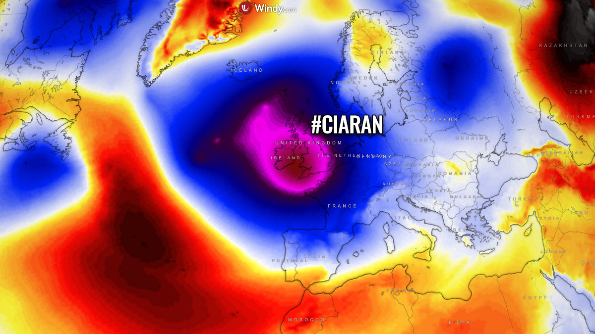
The first Atlantic storm Ciaran is coming up Thursday this week, with rapid cyclogenesis occurring before the major impact with violent, hurricane-force winds and heavy rain squalls blast into Ireland, the UK, the English Channel, northern France, and Benelux on Thursday.
The overall weather picture across the North Atlantic in recent weeks is influenced by the unseasonably warm weather, which was triggered by the El Nino global weather pattern effects. This has resulted in high moisture and persistent rainfall with flooding events across western, southwestern, and central parts of the European continent.
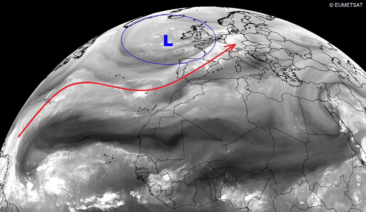
The following water vapor satellite image indicates this high moisture present over much of Europe, with a large cyclonic depression over the North Atlantic and Western Europe. The red arrow indicates the moisture transport feeding the frontal system heading into Europe all the way from the tropical western Atlantic.
Combined with strong cyclones, the combination resulted in multiple rounds of excessive rainfall with floods. Similar conditions are forecast to remain in place for at least another two, possibly three weeks, with much more rain coming up through mid-November 2023.
Our eyes are now turning to the potential very powerful storm Ciaran, which is forecast to rapidly develop along the frontal wave crossing the North Atlantic by mid-week. The general weather model consensus suggests a potential violent windstorm will blast Ireland, the UK, France, and Benelux on Thursday, November 2nd.
High-resolution models also appear to be supporting a high-risk signal for a Sting Jet wind maximum towards the English Channel, affecting both coasts of southern UK and northern France. A Sting Jet is known to bring the most intense windstorms in Europe in autumn and winter months, with peak wind gusts reaching 100 mph or more.
What is a Sting Jet, and Why Does it Bring Violent Winds?
A sting jet is a narrow core of violent winds that form within the rapidly intensifying North Atlantic extratropical cyclones. It leads to powerful windstorms towards the surface. Sting jets are associated with the strongest and most damaging windstorms, resulting in violent, hurricane-force winds with the most notable events.
Let’s see how they form and why it is important to understand their potential threats.
Sting jets can bring a swath of particularly intense winds, often leading to peak wind gusts well above 160 km/h (100 mph). Sometimes even surpassing 200 km/h (125 mph), causing extensive severe tree and structural damage. It is a relatively narrow zone of the powerful wind maximum, originating from inside the mid-tropospheric cloud head within the explosive cyclogenesis or a bomb cyclone in the Atlantic Ocean.
Once the sting jet is fully developed, the wind maximum is also very easily recognizable on satellite imagery as the shape of the cyclone’s comma cloud is hooked, just like a scorpion’s tail. This gives this dangerous wind region its famous name.
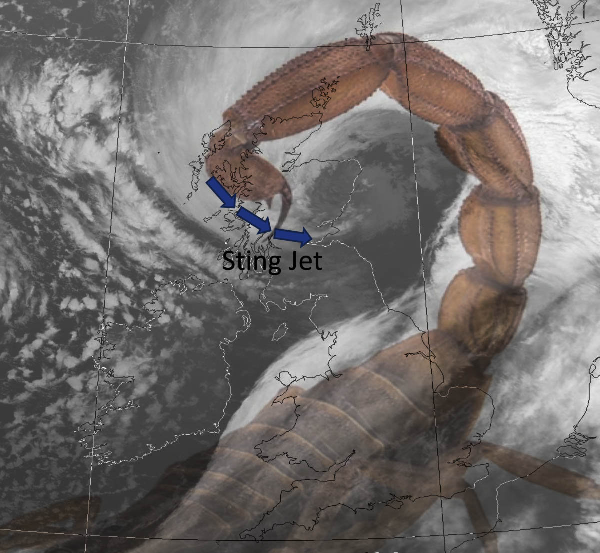
The composite satellite image above hints at the textbook example of the cyclone overlapped with a scorpion’s tail.
In the following chapter, we will discuss the formation of the Sting Jet. The extratropical cyclone has two frontal zones, the warm front and the cold front following it. A strong flow of cold air develops into the cyclone ahead of the warm front. This is known as the cold conveyor belt.
Behind the main cold front, a colder and much drier air mass. It is usually originating from the Arctic region, and it flows towards the cyclone’s core. It forms a dry intrusion towards the center of a deepening low. The dry intrusion typically rounding the low is emerging from the southwest direction.
The cold conveyor belt brings cold and moist air towards the center of the rapidly developing extratropical storm, and it happens together with precipitation such as rain and snow. At the same time, the dry intrusion brings cooler and very dry air into the cyclone.
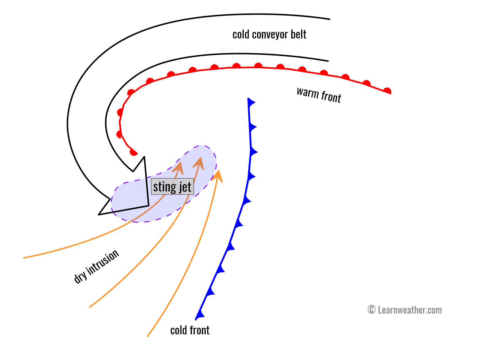
Above: Schematic view of a Sting Jet Formation
As the precipitation from the cold conveyor belt falls into the layers of air within the dry intrusion streak, droplets quickly evaporate, further cooling the air mass. This is a process known as evaporative cooling.
At the final stage of the sting jet process, strong winds descend towards the surface and intensify further as the air parcels dry out. These winds are grazing through the layers with the evaporation of the air on the nose of this descending jet. Thus creating a clear path through the precipitation with the evaporative cooling process, leading to the air becoming much denser within the jet.
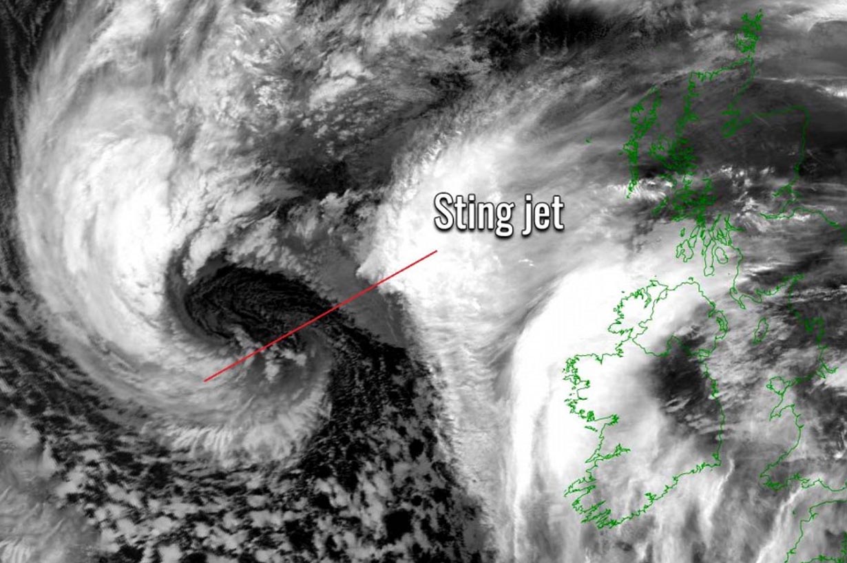
Above: Banded cloud head on the nose of a Sting jet
The result is the acceleration of the downward momentum or, in other words, violent winds that are pushed down with higher force towards the tip of the cloud head when it wraps around the center of the cyclone.
All these processes with the sting jet occur at altitudes up to about 3-4 km above sea level surface. The cooled air, being much denser than the surrounding air, descends rapidly to the surface, producing even stronger winds within the already intense wind field of the cyclone.
The entire region of this cooled, accelerated airflow is narrow, forming what is known as a sting jet.

Above: Textook example of a Sting jet
Read more about Sting Jet formation on our educational site LearnWeather.com
The extratropical storms’ rapid formation and intensification are also strongly influenced by the warmth of the fuel for the storm beneath, that’s the ocean water temperature. It remains record-breaking throughout this autumn season.
Historically Warm North Atlantic Waters Continue
The Global seawater surface temperatures have been impressively anomalous this year, and this continues lately, month by month. It is the same for the North Atlantic Ocean; sea water temperatures remain much above the normal for the end of October than any year before.
The following chart represents the sea surface temperature for the whole North Atlantic over the last 30 years. We can see there were new records set starting in early March 2023, and they remain above any of the previous years. The average sea surface temperature of the North Atlantic right now is +23.7 °C, about 1 °C above the midline of all years and also +0.3 °C above the previous record for this period, set last year.

Basically, this means the North Atlantic Ocean remains really warm compared to previous years and the long-term average. The chart below indicates the sea surface temperature anomaly this week; mainly, all areas are above normal. A few spots around Greenland and the Gulf Stream can be seen in blue colors. Waters are about 1-3 °C above normal along the western coasts.
Notice also how significantly warm the Mediterranean Sea is, which is the main source of the moisture and heavy rainfall events that are recently ongoing in central Europe.

As discussed earlier, the deep Atlantic storm systems need two main ingredients for their development: strengthening and evolution. Thus, the Arctic cold air mass intrusion from the north spreads above the warm seas. In this case, we see the Atlantic is also much warmer than normal, which helps the storms to collect more energy.
Let’s now dig into the evolution of the upcoming cyclonic events.
Weather Pattern Significantly Strengthens Over the Atlantic and Europe This Week
What’s striking on the global weather models charts this week is a particularly significant evolution of the large-scale weather systems triggered by the sea temperature anomaly between North America and Europe. The first intense Arctic Blast has reached Canada and the U.S., and part of it is also emerging into the North Atlantic.
This particular wave will dig far south into the North Atlantic mid-week and develop a rapid cyclogenesis towards western Europe. The following chart indicates a very deep upper low is forecast to develop over the UK and Ireland on Thursday.

Notice the pressure gradient will be strong on its front end and southern edge, meaning the zonal jet stream flow will be very intense. Pumping the moisture and warm air from the southwest will produce much warmer weather across the continent.
Therefore, the unusually warm weather will continue across much of Europe, with the warmest air mass across central, southern, and eastern Europe. The low over Western Europe will be so large that its influence will dominate much of the European continent this week.

This large Atlantic storm will form after a strong westerly jet stream brings a deep wave off Nova Scotia, Canada, early this week. It intensifies rapidly while tracking across the ocean.
It will strengthen the jet stream between this low and the blocking High over the Azores. This helps the associated surface frontal to develop and move into Western Europe rapidly. Average wind speeds in the core of the jet stream will be above 150 knots or 170 mph (280 km/h).
Air travelers coming from North America will have their trips quite shorter than usual. At the same time, those going westbound will have their flights a bit longer. Both, however, will likely experience some serious turbulence within this violent jet.

The exact position of the surface cyclone’s and Ciaran storm’s core is not yet well-defined, as the system is still developing off North America on Monday. However, the surface pressure is forecast to drop significantly once the rapid cyclogenesis occurs on Wednesday.
Various models suggest that central pressure will fall between 25 and 30 mbar within the period of 24 hours of the more rapid intensification. Pushing the core’s pressure near 950 mbar as it hits southern UK and northern France on Thursday early morning.
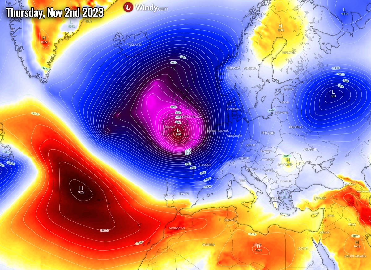
Once this occurs, the system will also be characterized as a bomb cyclone. This is an official classification of the extratropical storm with a pressure change of more than 24 mbar within a 24-hour period. The process leading to this is known as bombogenesis, as an explosive development of the surface cyclone takes place.
The First Violent Atlantic storm Ciaran will impact the UK, Ireland, and France on Thursday
Looking closer over the impact of storm Ciaran over Ireland, the UK, and France on the following charts. Among the mentioned countries, Ireland will likely be the least affected as the core of the low will travel more south. But still, strong to severe winds and waves will graze southern Ireland.
The central pressure of storm Ciaran will reach around 950 mbar, centered somehow between southwestern England and northwestern France. Nonetheless, the impact will significantly impact both countries, especially coastal areas.

Depending on where exactly the low will travel, the impact will be the most intense. The further north the core travels, the more winds blast southwestern England. If it turns to take a more southerly track, the impact will be the strongest in Brittany, northwest France. Intense winds will blast the English Channel in any case.
The following chart is based on the more northerly trajectory of the Ciaran, thus bringing the most violent hurricane-force winds to southwestern England and the Channel.
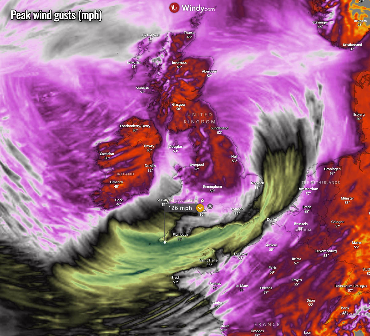
Peak wind gusts will likely exceed 100 mph, possibly even 120 mph or 190 km/h on the most exposed elevated spots near the coastal areas of South West England and Brittany, France. Significant impact is expected on road traffic and vessels in the English Channel and could cause structural damage to buildings and numerous uprooted trees.
The large size of storm Ciaran will develop significant wave height as well, likely reaching 12-14 meters before blasting into the coasts.

Storm Ciaran is also forecast to bring quite a high rainfall amount for all affected countries. Between 60 and 120 mm is likely until Friday, possibly even more locally. Causing local flooding.
The most intense rain squalls with gale-force to hurricane-force winds are expected along the main cold front, which will cross along the leading edge of the core in early Thursday morning. Moving rapidly from west to east.

The highest amounts of rain are expected with the orographic lifting into higher terrain in southern England and Wales.
Another Potentially Violent Storm Likely To Follow Next Weekend
While conditions will gradually improve late Thursday as Ciaran ejects off England and weakens over the North Sea, the general weather model consensus hints at another large Atlantic storm to follow over the weekend.
Another intrusion of very cold Arctic air mass is expected to dig into the North Atlantic, thus creating yet another explosive cyclogenesis towards Western Europe. It would be similar or even larger in size compared to the Ciaran storm.

The pressure chart for next weekend is even more impressive, with an enormous low-pressure system dominating Europe. Centered over the UK with pressure near 950 mbar again.
Its effects would be significant for the continent, as high moisture and warm air mass would continue advecting into central and eastern parts. Likely triggering more heavy rainfall and flooding events.

Attached below is the Meteogram for Brest, France, over the next 14 days, based on the ECMWF weather model. The left chart represents the temperature and precipitation, and the right chart indicates the average wind speed.
We can clearly see the impact of Ciaran will be significant with both heavy and excessive rainfall and severe winds. Notice the winds chart represents an average 10 m wind speed so that the actual wind gusts will be much higher.

Stay alert for potential dangerous driving conditions and windstorm threats to areas affected.
Wxcharts, Pivotalweather, and Windy, provided images used in this article.
See also: