The visual appearance of the updraft can tell a lot about its strength and potential to produce a strong thunderstorm. As the updraft rises through various phases of Cumulus and potentially Cumulonimbus, it cools and eventually loses buoyancy.
An updraft is a rising column of warm, moist air that rises within a thunderstorm due to buoyancy. The updraft fuels the storm by lifting moisture to colder altitudes, where it condenses into clouds and precipitation.
In addition to the speed at which the updraft increases, the appearance of its edge indicates its strength.

Sharp, crisp updraft on a severe thunderstorm over northern Italy. This is a strong updraft. Photo: Marko Korošec.
A sharp, crisp edge that may resemble an explosion indicates a strong updraft. It may, sometimes, form a pileus cloud cap on top of it. On the other hand, a soft, fuzzy edge indicates a weak updraft that has lost its strength and upward speed and is likely not rising anymore.
Key characteristics of the updraft
Multiple key characteristics of the updraft will define how powerful thunderstorms form. A combination of these ingredients leads to violent thunderstorms.
- Speed and intensity: The more substantial the updrafts are, the more powerful storms can develop. Vertical wind speeds can range from 10-50 m/s (36-180 km/h) or even higher in severe storms.
- Moisture Content: Higher humidity in the updraft leads to more cloud formation and vigorous storm development.
- Buoyancy: Determined by instability (CAPE – Convective Available Potential Energy). Higher CAPE values (more than 2500 J/kg) result in more vigorous updrafts.
- Tilting and rotation: Wind shear can cause updrafts to tilt or rotate, influencing storm longevity and potential tornado formation.
The upward speed of the updraft vs. the thunderstorm strength
Fairweather Cumulus humilis and Cumulus mediocris clouds typically have gentle updrafts with 2-3 m/s vertical speeds.
Weak thunderstorms may have vertical updraft speeds of 6-10 m/s. At such a speed, a thunderstorm will vertically develop by 10 km in about 15 minutes.
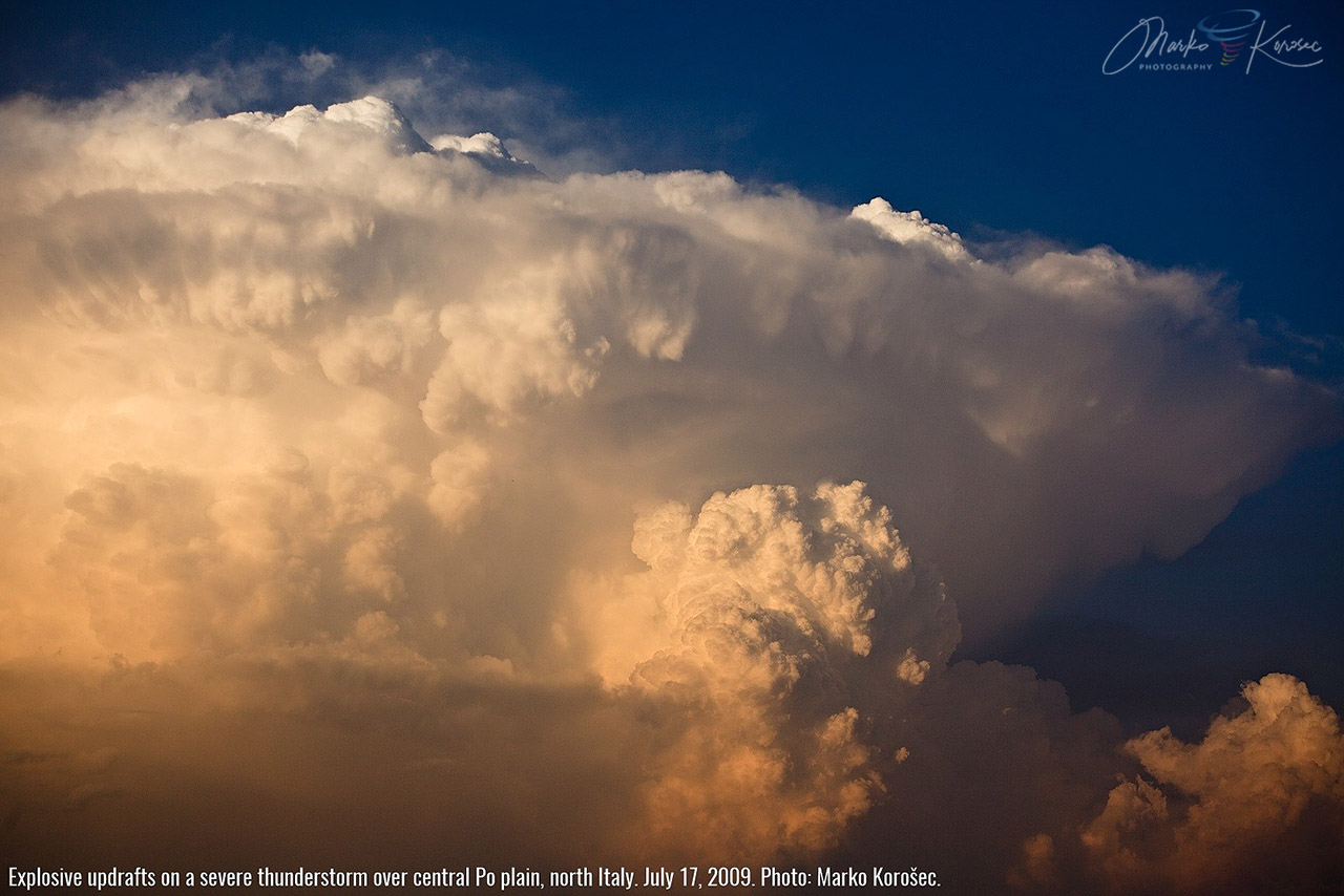
Explosive updrafts on a severe thunderstorm over the central Po plain, north Italy. July 17, 2009. This storm had an updraft strong enough to hold aloft tennis ball-sized hail. Photo: Marko Korošec.
Next are the moderate updrafts, whose speeds reach 10 to 30 m/s. These vertical wind speeds support strong thunderstorms associated with heavy rainfall, lightning, and generally small to marginal hail.
On the other side of the spectrum are severe thunderstorms. A severe thunderstorm may have a vertical updraft at 30-50 m/s. In extreme cases, severe thunderstorm updrafts grow to 75-80 m/s!
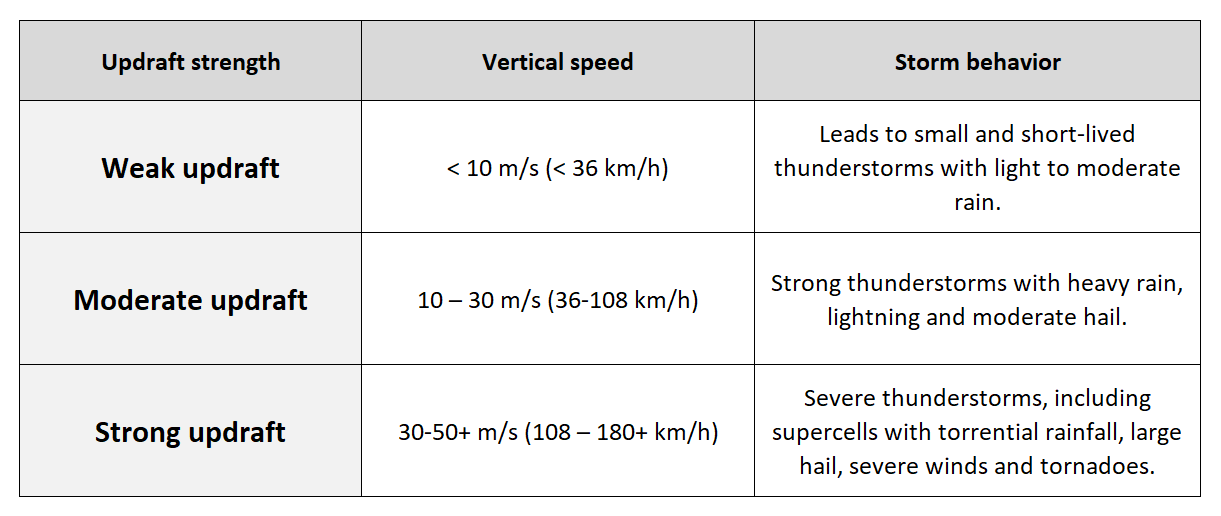
The most vigorous updrafts often develop intense supercell storms that bring large or giant hail, torrential rainfall, severe damaging winds, and tornadoes.
That means the updraft rises by a full kilometer in less than 15 seconds and can reach 10 km in 2-3 minutes – this is called explosive thunderstorm development.
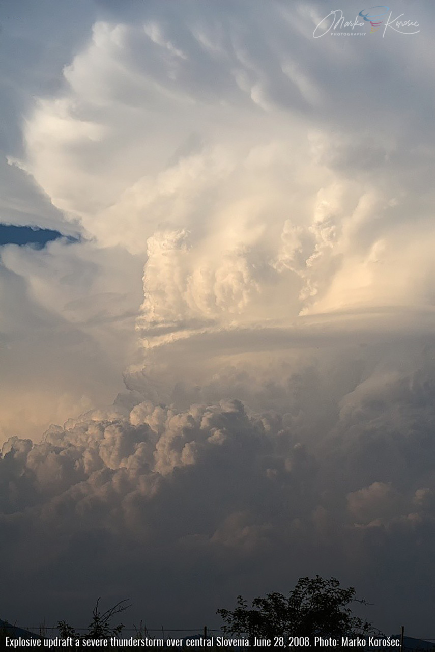
Explosive updraft on a severe thunderstorm over central Slovenia. Note the crisp edges of the updraft, indicating its strength. June 28, 2008. Photo: Marko Korošec.
What role does the updraft strength play in severe thunderstorms?
The storm’s updraft is the core driver of (severe) thunderstorms. It defines their intensity, longevity, and the potential for weather hazards and phenomena. A powerful, sustained updraft often leads to destructive weather phenomena like large to giant hail, severe damaging winds, and tornadoes.
We divide the updraft’s strength and speed in the severity of the thunderstorms into several key roles. Severe storms are the most violent and dangerous type of thunderstorms.
- Hail formation and growth—When thunderstorms contain stronger updrafts, they suspend hailstones for longer, allowing them to grow large before they become too heavy and fall to the ground.
- Lightning — The more substantial the updraft, the more likely lightning production will follow. Stronger updrafts create more substantial charge separation, leading to increased lightning activity.
- Supercell formation — In combination with wind shear, rotating updrafts take place and form supercell thunderstorms. These rotating updrafts are known as mesocyclones.
Related topics:
Types of convective clouds – from fair-weather clouds to thunderstorms
Thunderstorm basics: Understanding the power of nature
Back-sheared anvil: The role of wind shear in shaping cumulonimbus anvil
Read an in-depth scientific article about The High-Speed Updraft—The Key to the Severe Thunderstorm