Europe ending its first month of the meteorological spring season of 2023 soon, while the weather forecast is hinting at a powerful cold blast into west-central portions of the continent this final week of April. This increases potential morning frosts in parts of the west, central and eastern Europe, including the Balkan peninsula. Later this week, a significant heatwave will expand into Spain.
The winter season of 2022/2023 was rather mild once again across many parts of Europe, lacking snow and any particularly strong cold outbreaks. One of the reasons behind this was the intense Polar Vortex aloft and the decaying La Nina global circulation. After the vortex weakened, March was quite cold, followed by a few weeks of warmth in April at least, but the cold weather didn’t say the last word yet.
The general weather pattern over the North Atlantic and Europe this final week of April will flip to a progressive northerly circulation. A strong upper High is building up over the Arctic region, allowing a deep trough to form into north-central Europe. It is forecast to release a lot of cold air towards the south, which is not welcome in the spring, especially not this late in April.
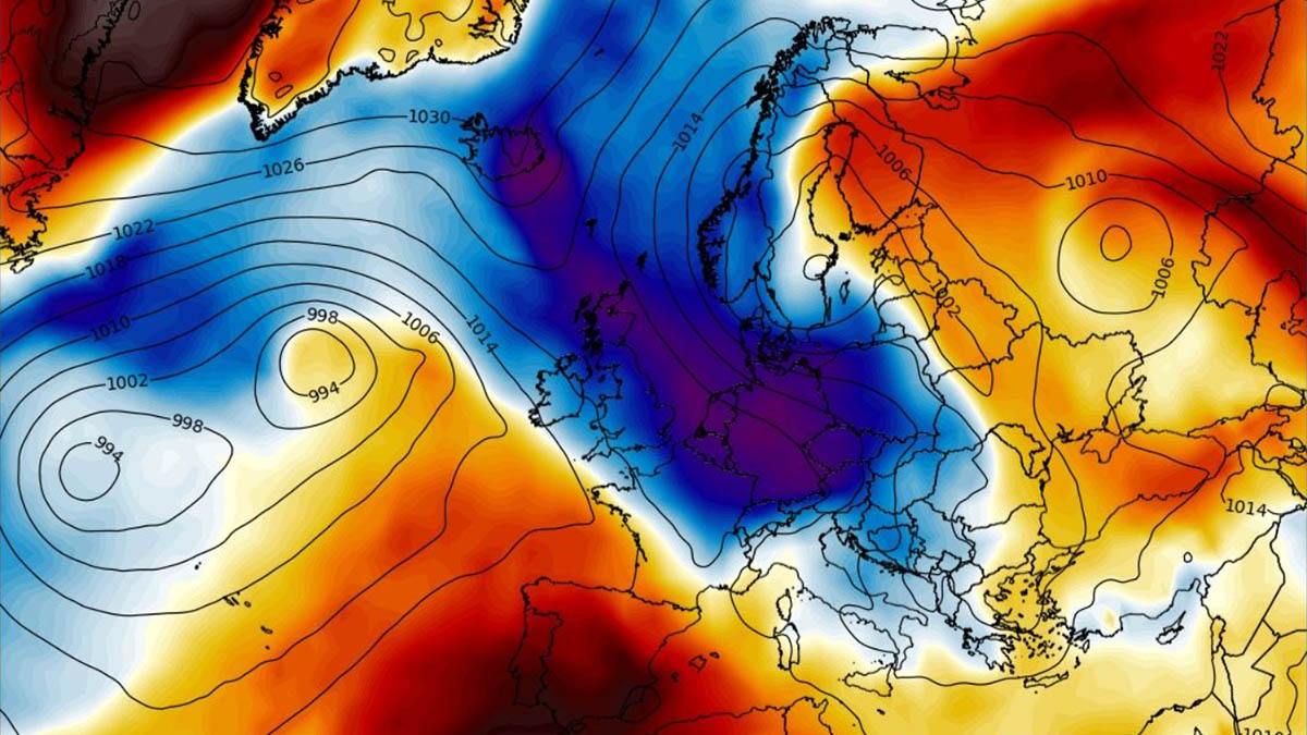
The blocking pattern will remain over the Arctic for a week. At the same time, another blocking High will establish in southwestern Europe, with the trough in between locked in over the central and northern parts of the European continent. Normally this brings unsettled weather conditions as surface depression forms over Scandinavia.
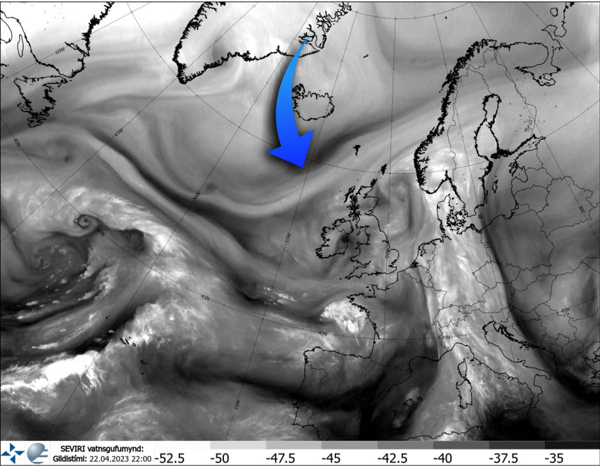
The changing weather pattern is already seen on the satellite imagery, where we can notice an intrusion of colder air mass from the Arctic region towards the south while the frontal system is moving from western into central Europe.
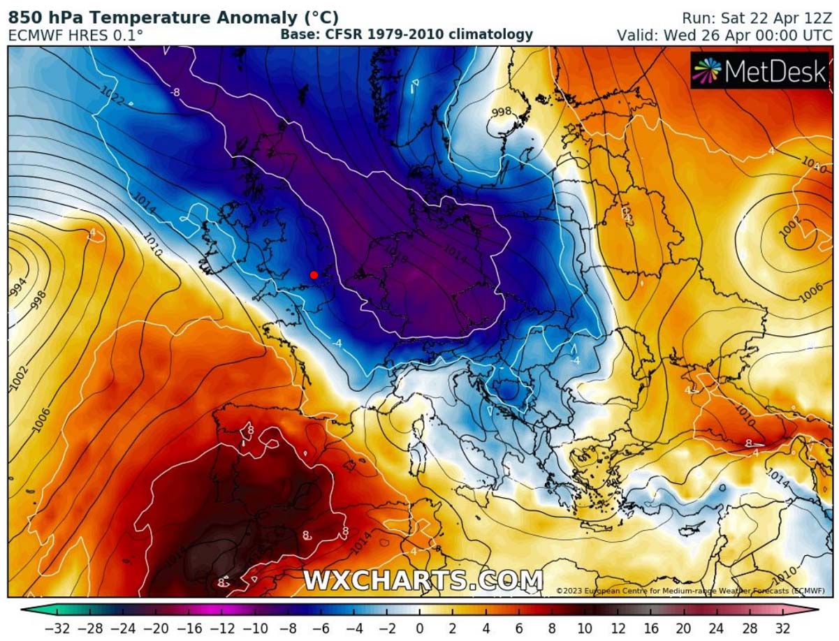
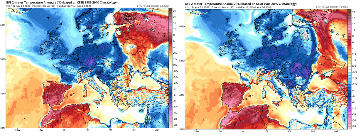
However, the further strengthening of the trough while moving into Scandinavia will also intensify the cold weather in its wake so that temperatures will be much lower in the coming days this week. Close to around 12 to 15 °C below normal in the lowest levels from Tuesday through Thursday.
The intense surface low will also trigger heavy and abundant snowfall in parts of western Scandinavia, especially central Norway and Sweden. Some new snow will also develop over the Alps, resulting from the moisture advection with the northwesterly flow towards the Alpine region.
Days will be much colder than the average from Monday through Thursday, particularly across western and central Europe. Where skies will be clear overnight, very cold mornings with potential frosts could follow. This could be vulnerable to blossoming fruit trees and early agriculture in many areas.
A BLOCKING HIGH OVER THE ARCTIC AND DEEP TROUGH WITH A COLD FORECAST OVER EUROPE AS THE SPRING SEASON ENDS ITS FIRST MONTH
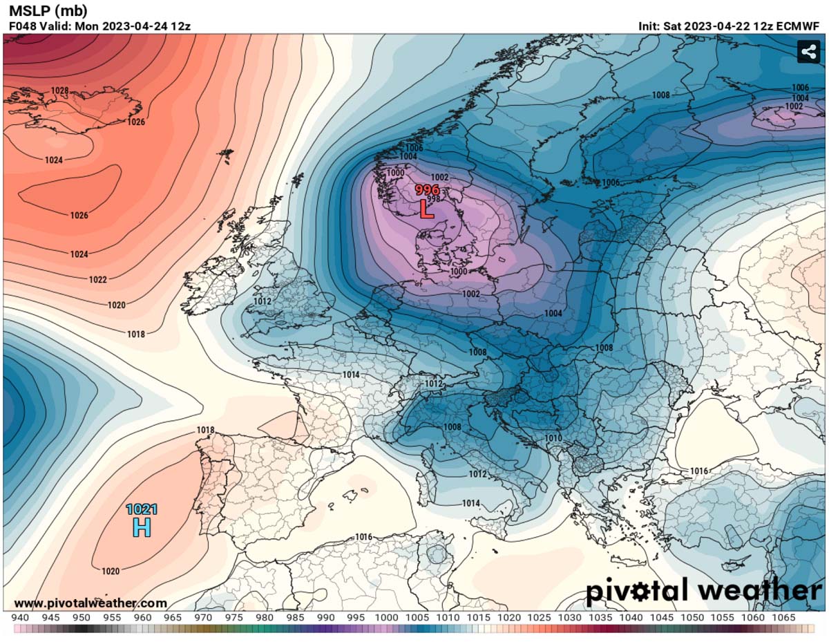
Starting Monday, the establishing weather pattern over Europe and North Atlantic leads to a rather textbook intrusion of the cold northerlies towards the European continent. The upper High has been gradually building over Greenland in the last few days.
This allows the cold air mass to turn south on its eastern side, leading to a development of a surface depression over western and central Europe.

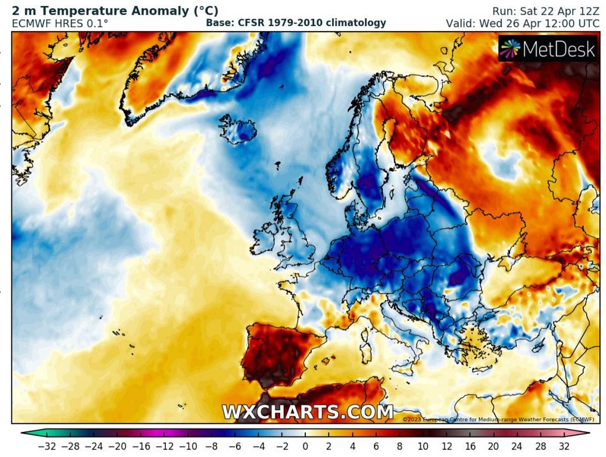
As we can see from the next temperature anomaly chart below, the tight pressure gradient between the High and the Low drags the significantly colder air into western Europe first, then into central Europe by mid-week days. It is forecast to spread further south and east into Eastern Europe and the Balkan peninsula on Thursday.
The surface cyclone forming over northern Europe will be large and persist for several days. Allowing the cold advection on its wake to maintain throughout early and mid-week, gradually spreading towards central Europe and farther east as well.
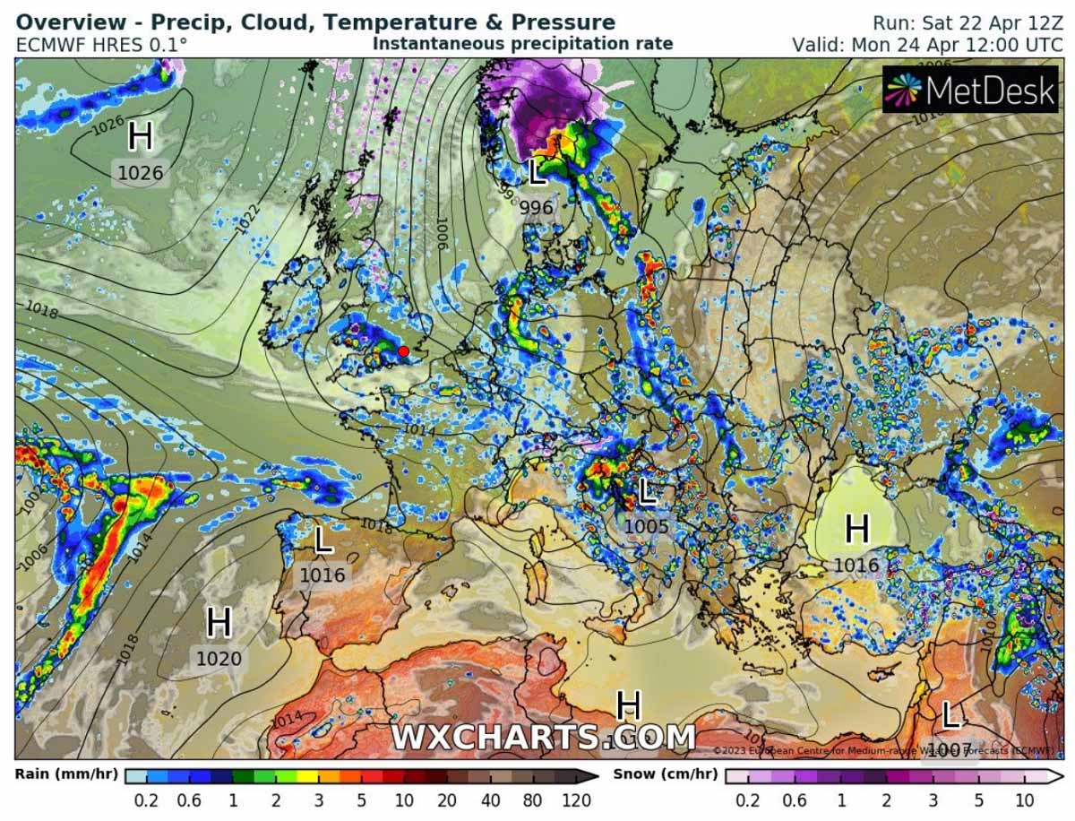
Precipitation will develop around the surface low, as rainfall along the main cold front, with the highest amounts around the northern Balkans and eastern Alpine region on Monday. Rain will turn to snow on the northern side of the Alps as cold advances south.
Heavy precipitation, including snowfall, should develop across western and central Norway, also central Sweden, where the combination of the deep surface low and advection of high moisture establishes on Monday and Tuesday.
As the North Atlantic surface high-pressure system persists into mid-week, the deep cyclone in Scandinavia strengthens the cold over Europe. Spreading across central Europe and also into the Balkan peninsula after Wednesday.
Temperatures in the lowest levels of the atmosphere will be very cold for the spring season, even more than 10 °C below normal in some areas, particularly over Benelux, Germany, Czechia, Slovakia, Poland, and northern Balkan countries.
The cold over the central parts of the continent should remain until Thursday, as a new strong High starts to build up over southwestern Europe and gradually push the large trough to the east for the next weekend.
A LOT OF SNOW FOR SWEDEN AND NORWAY, MORE RAIN FOR CENTRAL EUROPE AND THE WESTERN BALKANS
As mentioned earlier, the position of the surface high-pressure system over the Atlantic and the low over Scandinavia allows the north-northeasterly winds to drag unseasonably cold air mass far south into western and central Europe. This also helps the large surface cyclone to maintain through mid-week.
The main low sits over northern Europe, while secondary low forms along the moving front on Monday in the Lee side of the Alps. The frontal system will bring another good amount of rain to parts of northern Italy, Slovenia, Croatia, and southern Austria.
Precipitation will be quite heavy and excessive due to moist west-southwesterly winds. When this occurs, the western side along the Dynaric mountain range in the western Balkans receives typical orographic precipitation. Locally 40-70 mm of rain seems quite reasonable by Tuesday evening in some places.

On the northern side of the front, the cold in the lowest levels will already reach the ground so that rain will turn to snow also in the over the Alps.
But significant snow accumulations are forecast for parts of Sweden and Norway where the great overlap of strong warm and moisture advection aloft with cold beneath occurs. There, 40-80 cm of fresh snow could accumulate over the higher elevations again.

After mid-week, when the low begins a gradual weakening phase and moves east, snowfall is also forecast to develop across central Finland and areas further east. But it will be less abundant than over central Sweden.
MAJOR COLD WITH FROSTS FORECAST FOR CENTRAL EUROPE ON TUESDAY AND WEDNESDAY MORNING
One of the greatest concerns with a cold weather pattern arriving this late in the spring season is usually the potential morning frosts. The warmth in the recent two weeks has accelerated the vegetation in many areas, so the fruit trees have started to bloom in the valleys. And the valleys are more threatened when we get a significant cold outbreak in spring.
The cold accumulates near the ground because it is much denser than the warmer air. So large valleys accumulate this cold air easier, resulting in the temperatures even lower than the surrounding higher elevations.
Morning near-surface temperatures on Tuesday and Wednesday will be much colder than this week’s in many areas, even below freezing in some areas.
With 2m temperatures being locally more than 8-12 °C below normal, this should bring potential freezing late April mornings across western and central Europe this week. How low temperatures could fall strongly depends on the overnight cloud coverage and the winds on Tuesday and Wednesday.
Normally, a calm, clear sky night allows temperatures to drop significantly more than during a cloudy or windy night. This happens due to the radiation spreading from the ground into the sky, resulting in the cooling of the ground levels. The anomaly forecast for Leipzig, Germany, reveals the cold will be quite strong on Wednesday.

The morning temperature forecast for Wednesday across Western and Central Europe is attached below. Even down to around -3 °C is forecast across parts of Benelux and Germany.
Below-freezing is also forecast in northern England, France, Czechia, and Austria.

Thursday will also be another day with cold temperatures in the morning, especially for the Balkan peninsula countries, as low wind conditions are forecast overnight.
Temperatures could drop below freezing a degree or two in parts of Bosnia, Serbia, Bulgaria, and Romania.

How much threat this cold season-like low temperatures could bring to the starting vegetation and early stages of blossoming fruit trees depends on their phases. A strong frost with several degrees °C below zero could form, especially in the valleys.
A SIGNIFICANT HEATWAVE SPREADS INTO SOUTHWESTERN EUROPE
Once the low over Scandinavia finally weakens late in the week, a strong blocking High establishes into southwestern Europe with a powerful advection of warm air mass from the south. It appears likely that the warmth will create a heat dome, a locked-in pattern that will extend into early May as well.
The 850 mbar temperature anomaly chart below hints at a significantly warm air mass forecast to spread into the Iberian peninsula after Friday, extending into the next holiday weekend.
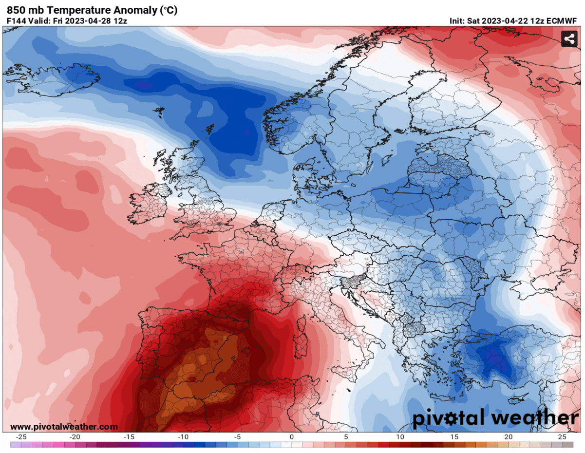
Temperatures in the lowest levels of the atmosphere are forecast to be around 12-16 °C above normal, meaning they would result in quite an intense heatwave for Spain. Further north, the cold will gradually vanish in the second half of the week.
The warm advection should push daytime temperatures into the upper 20s to low 30s across the whole Iberian peninsula, including southern France, with the hottest air mass for southern Spain and Portugal.

Peak afternoon temperatures across far southern Spain should exceed 35 °C from Friday into the next weekend, potentially even into the upper 30s °C will be possible in some areas.
This would become Europe’s first and most significant heatwave of 2023.
Windy, Pivotalweather, and Wxcharts provided images for this article.
See also: