A “cold train” weather pattern is coming for the United States in the second half of January, as a strong high-pressure zone rises over western Canada and Alaska. It will establish a cross-polar flow, bringing down colder air, boosted by the strong Polar Vortex core region over eastern Canada.
The Polar Vortex is without a doubt one of the key short-to-medium term weather factors during the cold season. It is strongly connected all the way from the ground up into the higher levels of the atmosphere. Every strong change or especially disruption of the Polar Vortex can have a profound effect on the weather development.
This is why we take great notice of the activity (or lack thereof) high above in the stratosphere and monitor it regularly. In the next days/weeks, the Polar Vortex will play an interesting role, helping to bring colder weather into the United States.
First, we will quickly and simply learn what the Polar Vortex really is and how is it so influential. We try to explain this in most of our winter articles, as this is an important part of every winter season. Such knowledge can really help to understand the bigger picture of how the weather operates globally.
THE POLAR VORTEX
In simple terms, the Polar Vortex is basically like a very large cyclonic circulation, covering the whole north pole, down to the mid-latitudes. It is strongly present at all levels, from the ground up into the middle atmosphere, but can have different shapes at different altitudes.
The Polar Vortex is so large that it can be divided into two parts. One is the lower (tropospheric) part and the upper (stratospheric) part. The stratospheric polar vortex plays an important role in weather development, while the lower tropospheric polar vortex actually “is” the weather and drives it around.
But what is the stratosphere? Well, all of our weather occurs in the lowest layer of the atmosphere called the troposphere. It reaches up to around 8 km (5 miles) altitude over the polar regions and up to around 14-16 km (9-10 miles) over the equator.
Above it, we have a much deeper layer called the stratosphere. This layer is around 30 km/18.5mi deep and is very dry. This is where the Ozone layer can be found. You can see the layers of the atmosphere on the image below, with the troposphere and the weather on the bottom and the stratosphere with the ozone layer above it.

The image below shows a typical example of the upper Polar Vortex at around 30km/18.5miles altitude in the middle stratosphere during the winter season. It has a very nice circular shape, as there is little in the way that can disturb its circulation under normal conditions.

In the next image below, we have the polar vortex at a much lower altitude, around 5km/3miles. It reveals the true shape and size of the polar vortex closer to the ground (cold colors). The closer to the ground we go, the more deformed the polar vortex gets because it has to interact with the mountains and overall terrain and also the dynamics from many weather systems.
Be aware of its cold arms or “lobes” extending into the lower latitudes, bringing colder air and snowfall into the mid-latitudes. These arms also pack a lot of energy and can create strong winter storms, like for example Nor’easters in the United States or very strong wind storms across the North Atlantic.
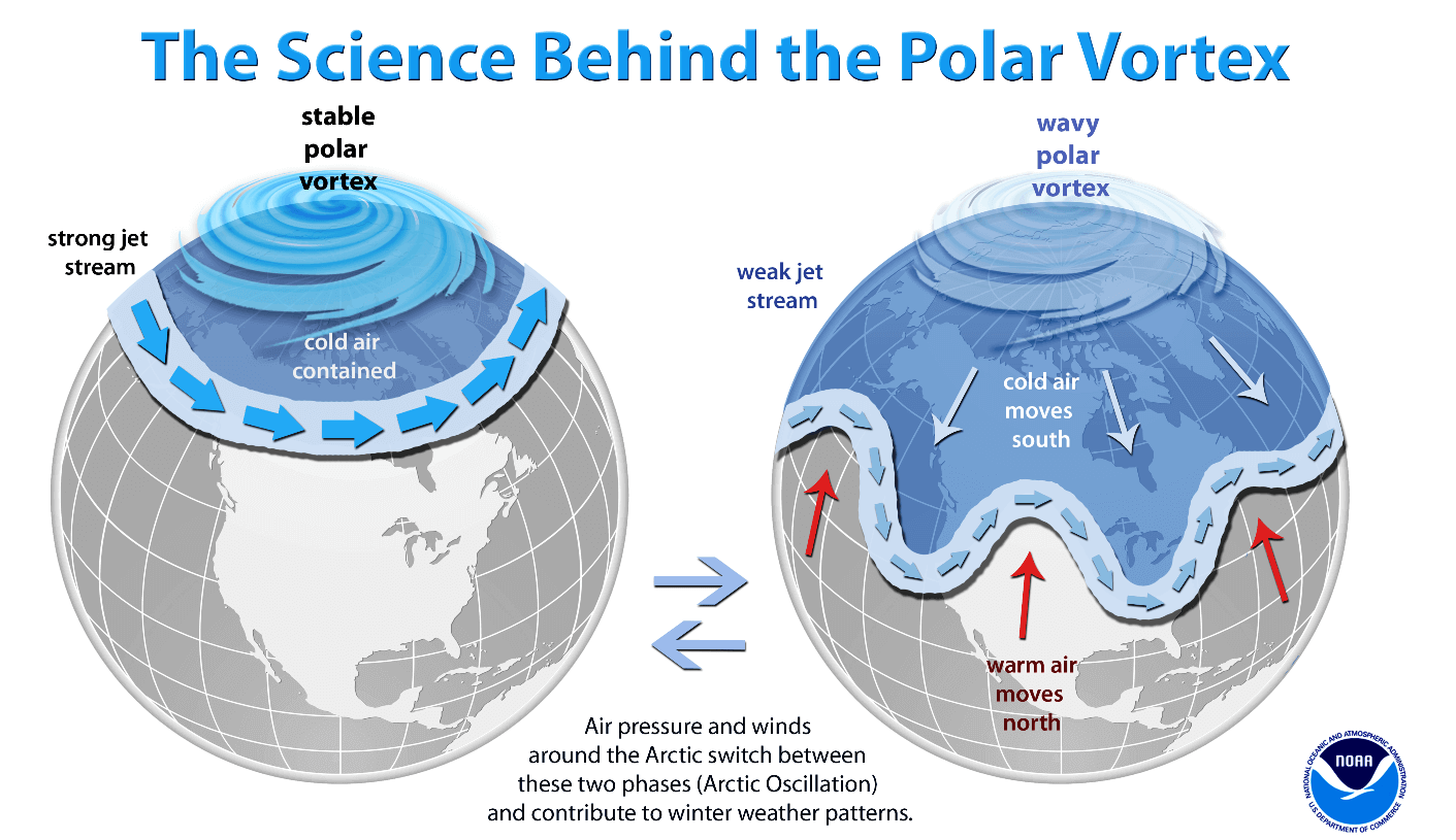
A strong Polar Vortex usually means strong polar circulation. This can usually lock the cold air into the Polar regions, creating milder winters for most of the United States and Europe.
On the other hand, a weak (wavy) Polar Vortex is just as dynamic as it sounds. It has a much harder time containing the cold air, which can now be released out of the polar regions, into the United States and/or Europe. Image by NOAA.
For an even better idea, we produced a high-resolution video for you below, which very nicely shows the Polar Vortex spinning over the Northern Hemisphere at around 23km/14miles altitude.
Video shows the NASA GEOS-5 forecast for the rest of the month. Notice how the polar vortex covers a large part of the Northern Hemisphere. You can nicely see how it spins over the Northern Hemisphere, connecting down to the weather circulation in the lower levels.
But how and why does the polar vortex even form?
Every year as we head into autumn, the polar regions start to receive much less sunlight. This means that cooling begins over the north pole. But as the polar regions cool, the atmosphere further south is still relatively warm as it continues to receive energy from the Sun. You can see the winter solstice on the image below when the polar regions receive little to zero solar energy, compared to regions further south.

So, as the temperature drops over the polar regions, so does the pressure. So as the temperature difference towards the south increases, a large low-pressure (cyclonic) circulation starts to develop across the Northern Hemisphere from the surface layers, far up into the stratosphere. This is known as the Polar Vortex.
While the stratospheric polar vortex is spinning high above our weather, it is still directly connected to the lower levels and can shape our daily weather in one way or another, as one large circulation over the entire hemisphere.
As you will learn below, we currently have a strong Polar Vortex in the stratosphere, but a weaker one in the lower levels. That will create a very interesting weather pattern across the Northern Hemisphere.
POLAR VORTEX AND THE WEATHER FORECAST
Usually, when looking at the polar vortex in the stratosphere, we use the 10mb level. That is around 28-32km (17-20 miles) in altitude. This altitude is considered to be in the middle of the stratosphere and provides a very good representation of the general dynamics of the stratospheric polar vortex and its downward connection.
The strength of the polar vortex is most often measured by the power of the winds inside it. Usually, this is done is by measuring the zonal (west to east) wind speeds around the polar circle (60°N latitude). Below we have an ensemble forecast for the 10mb winds.

Notice how the polar vortex at the 10mb level is actually stronger than normal for this time of the year. It is forecast to remain at a strong level, with slight oscillations in-between. It is not record-strong, but it does spin faster than normal for this time of the year.
Looking at the pressure anomalies over the polar regions in the past three months, we can notice an interesting progression. The next image below shows pressure anomalies from the surface into the upper stratosphere.
You can observe the strong low-pressure buildup in late November in the stratosphere. That was a strong polar vortex, connecting easily down to the surface levels in early December. But lately, strong high-pressure anomalies have emerged around and over the polar circle, which fight back against the stratosphere, “disconnecting” the upper and the lower polar vortex.

Looking at the latest polar vortex map, we can see that the stratospheric polar vortex is in a good shape. It doesn’t have the classical circular appearance and appears more oval in shape. But it has a strong stable wind field. There is a semi-persistent high-pressure area in the North Pacific, and one in the North Atlantic, that pressing against it, creating its oval shape.

Taking a look at the temperature profile at this level, reveals a broad cold-core over the Arctic, extending also into North America and Scandinavia. We can see the high pressure in the North Pacific, with some weak temperature anomalies around the cold core. Regardless, this is still a fairly stable Polar Vortex.

But, despite appearing disconnected, the upper and lower polar vortex is still basically one large area of circulation. So while the exact core energy is perhaps not strongly connected, its shape can reflect on both levels.
We can nicely see that if we look at the latest 5-day forecast of the pressure anomalies across the Northern Hemisphere. Notice the elongated profile of the lower polar circulation, also being compressed from the Pacific and the North Atlantic. This lower pattern is actually what is reflecting up into the stratosphere.
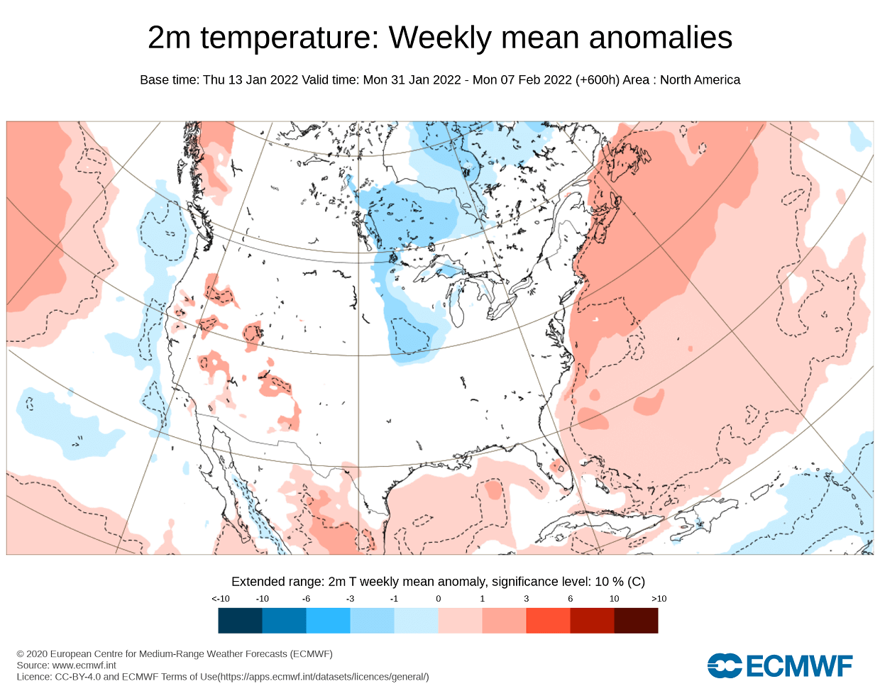
This is pretty much a disruption of the lower level polar circulation. The temperature forecast below for the same period shows the cold air anomalies in eastern Canada and the eastern United States. This is due to the northerly flow on the backside of the low-pressure area over the east, while a high-pressure system brings warmer air into the western United States.

Taking a closer look at North America, the coldest air can be found at the end of the week, moving over the country by early next week. Colder weather is expected across the central and the northeastern United States.
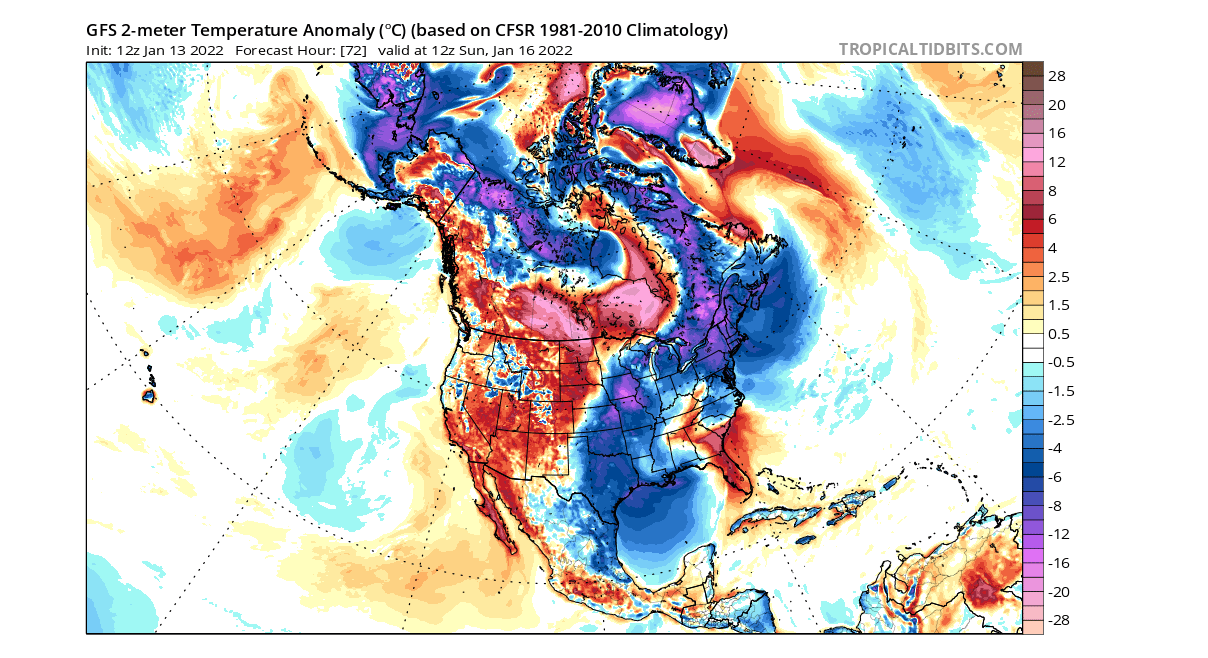
There is also a decent amount of snowfall expected with this cold air passage. A swath of snowfall is expected with the cold air entering over the Midwest, across the Ohio Valley, and extending over parts of eastern and much of the northeastern United States with decent snowfall amounts.

PRESSURE RISES OVER THE WEST
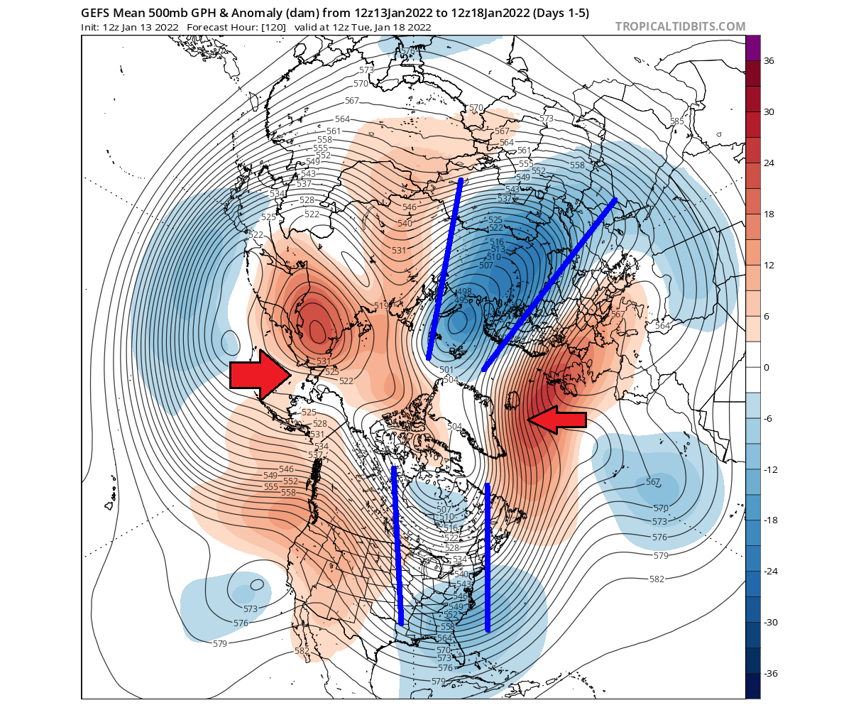
Going one week ahead, the pressure patterns will change a bit, with an important change over western North America. What we can see below is a rising and expanding high-pressure area over western Canada and Alaska. The ridge is pushing up towards the polar circle.

At the same time, that promotes a northerly flow from the polar regions and deepens the low pressure over eastern Canada. Looking at the jet stream forecast below, we can see this wind flow from the polar regions in the upper levels. This is a special pattern, also known as the cross-polar flow, which tends to bring colder weather into North America deeper from the northern regions.

The temperature forecast for this period shows the accumulation of colder weather over Canada, before being transported directly down into the central and eastern United States. Warmer than normal air is entering the polar regions from the Siberian sector, replacing the colder air moving out.
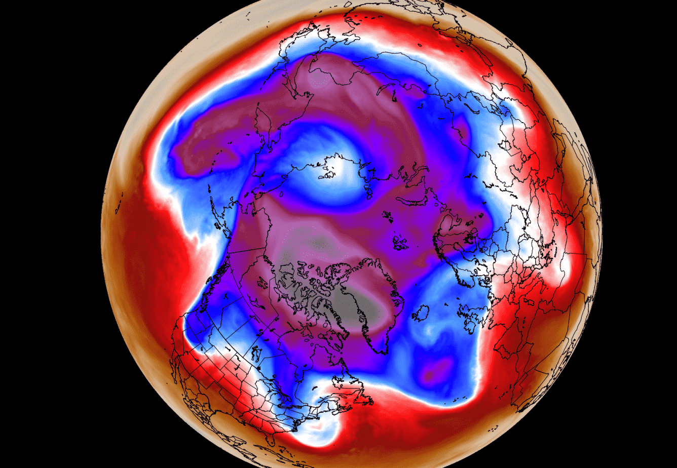
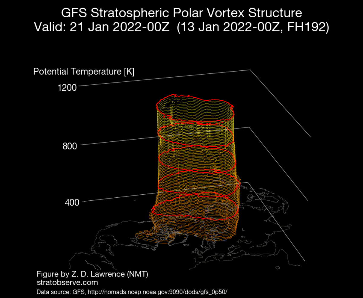
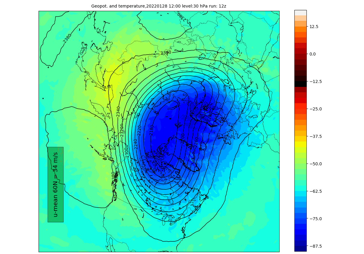
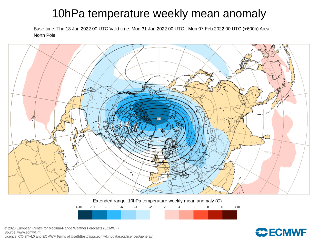
So where does the polar vortex fit into this? Well, during this time, the high-level (stratospheric) polar vortex regains some of its circular forms. But it keeps its elongated connection down into North America, seen on the image below. The level on the image is at 30mb, which is around 23km/14miles altitude. Image by weatheriscool.

We can see that especially well on the 3D structure. Notice the elongated shape of the polar vortex through all the atmospheric levels, with a unique extension down into eastern Canada. That does show how the low-pressure area in that region is connected to the core structure of the Polar Vortex.
The vertical pressure anomaly profile also reveals this connection We can observe the stratospheric low-pressure anomalies extending down from the stratosphere to the lower levels, with a direct connection in the -60 to -90 Longitude. That is exactly where the system over eastern Canada can be found.

Looking at the pressure anomaly map over North America, we can nicely see this low-pressure system. We now know that despite the overall lack of connection and influence from the Polar Vortex, this region is connected upwards and considered one of the core parts of the lower polar vortex. Together with high pressure in the west, it sustains a cold northerly flow into the continent and down into the United States.

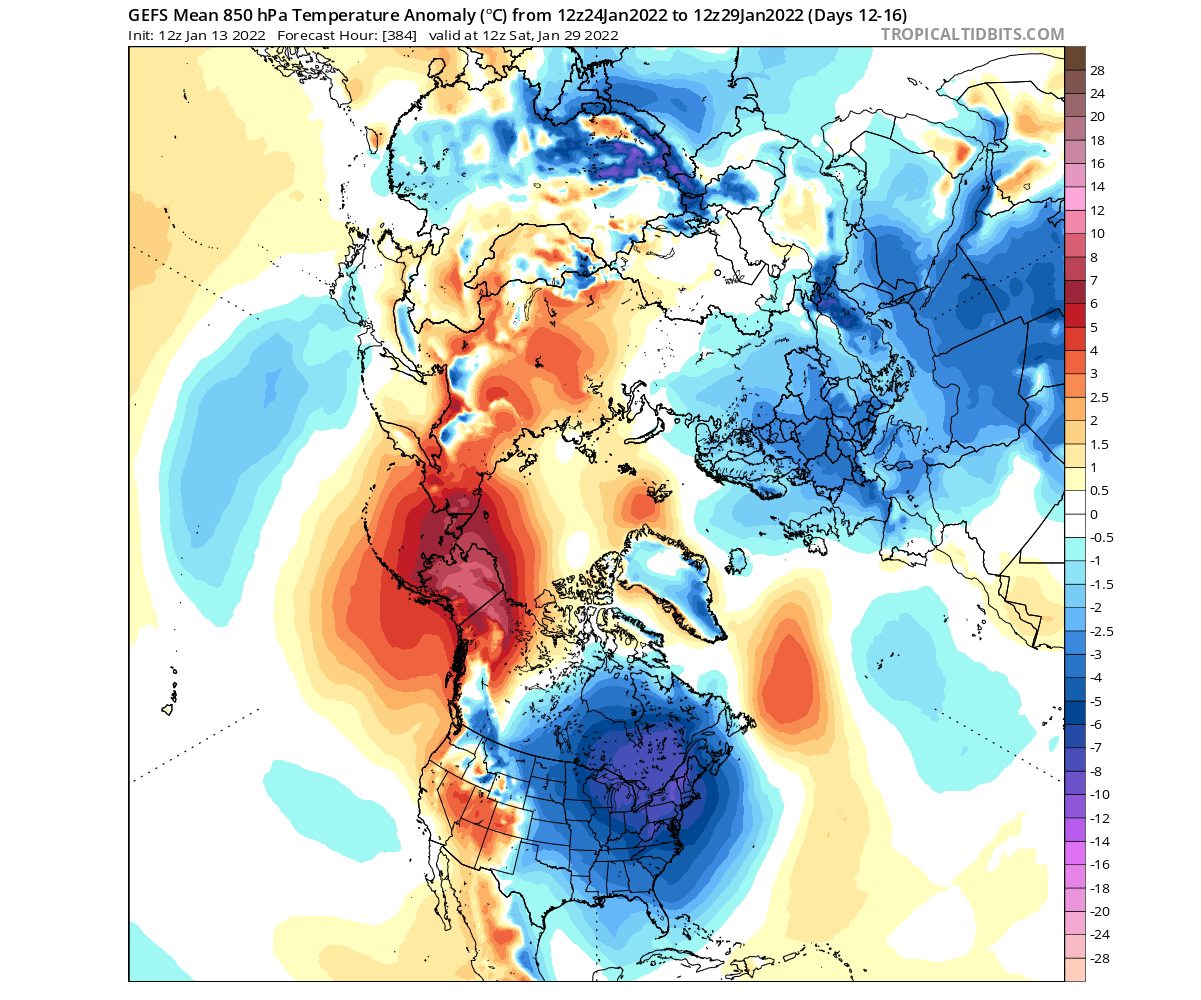
The colder airmass will spread from down from Canada over the Midwest and into much of the central and eastern United States. Below is a temperature anomaly forecast for later next week, showing one of the likely weather scenarios. The cold air is forecast to move towards the east, keeping the western United States under fairly normal to warmer than normal conditions.

Looking at the snowfall for this period, there is not much, or at least not as much as in the first period this weekend. The reason for this is the lack of moisture, as this cold air will be very dry. Below is a snow depth change forecast for this 5-day period.

We can see the melting of the snow cover across the Ohio Valley, dropped this weekend. But there will be some snowfall and snow depth increase over the Midwest, the Great Lakes region, and the northeastern United States. The numbers are low, as this is an ensemble forecast, and is showing an average picture of many scenarios.
CROSS POLAR FLOW CONTINUES
Going into the late month, the pressure patterns will persist. The strong ridge over Alaska will rise deeper towards the north, stabilizing the cross-polar flow into North America. Due to the low-pressure system over eastern Canada, the high-pressure zone in the North Atlantic will also be a stable feature, helping to bring some colder air also into Europe.

Warmer anomalies over Alaska can be found on the temperature forecast, as the ridge there pushes further north. That pushes out the colder air out of the polar regions and down into Canada and the United States. Due to the higher pressure also over the western United States, the southwestern states are expected to have warmer than normal conditions.
At this time, the stratospheric part of the polar vortex remains elongated, extending into eastern Canada, reflecting the lower structure. The level on the image is at 30mb, which is around 23km/14miles altitude.
The vertical pressure anomaly profile shows that the connection between the stratosphere and the lower pressure area over eastern Canada is sustained. The marked region shows the low-pressure anomaly connecting down from the stratosphere, in the -60 to -90 latitude region, in eastern Canada.

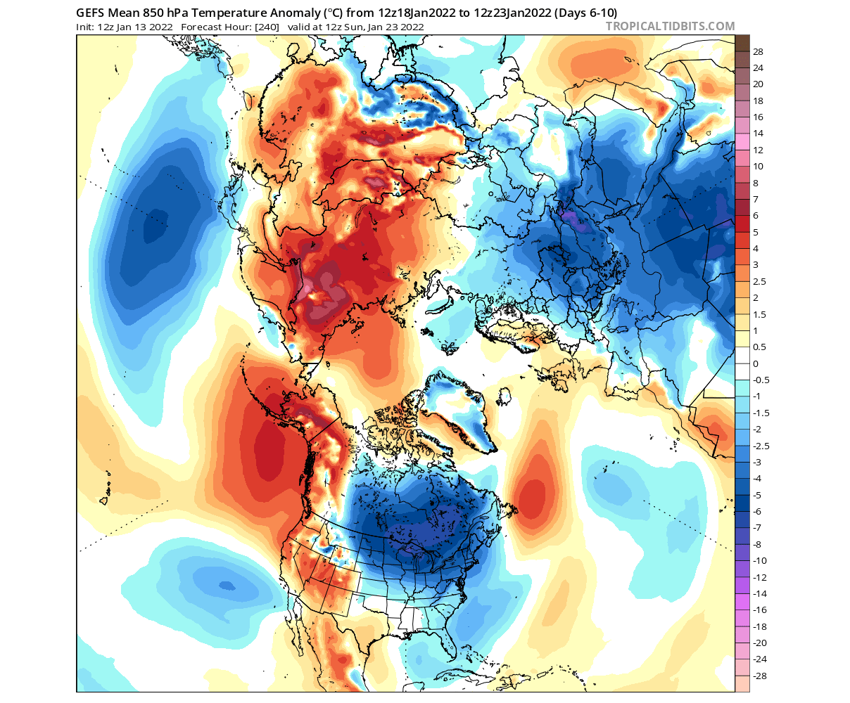
The weather progression in this period is looking similar to the previous one, with another round of colder air coming down from the north. Spreading from the Midwest into the central and southern United States and moving towards the east. This “cold train” is the nature of the cross-polar flow, being sustained by the pressure pattern, bringing down waves of colder weather.

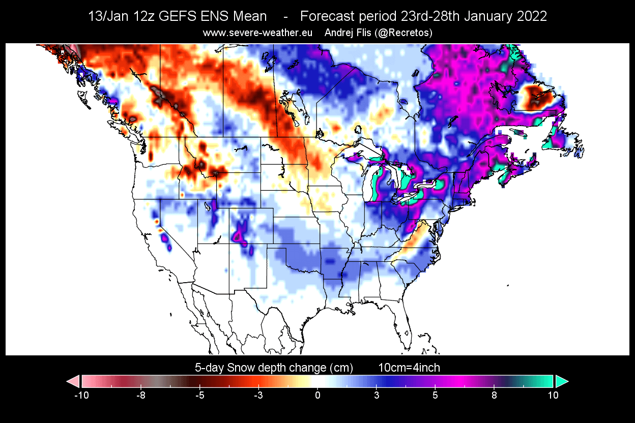
Below we have the snowfall forecast for this late month 5-day period. It shows snowfall and snow depth increase over much of the eastern United States, especially in the northeast. Notice the elevated snowfall in the Great Lakes region, having a strong signal for lake-effect snow. Parts of the southern United States also show hints of potential snow on the ground.
It is quite remarkable, how despite a strong stratospheric polar vortex, the lower level weather patterns are able to withstand it and actually take advantage of that power to boost the colder air transport.
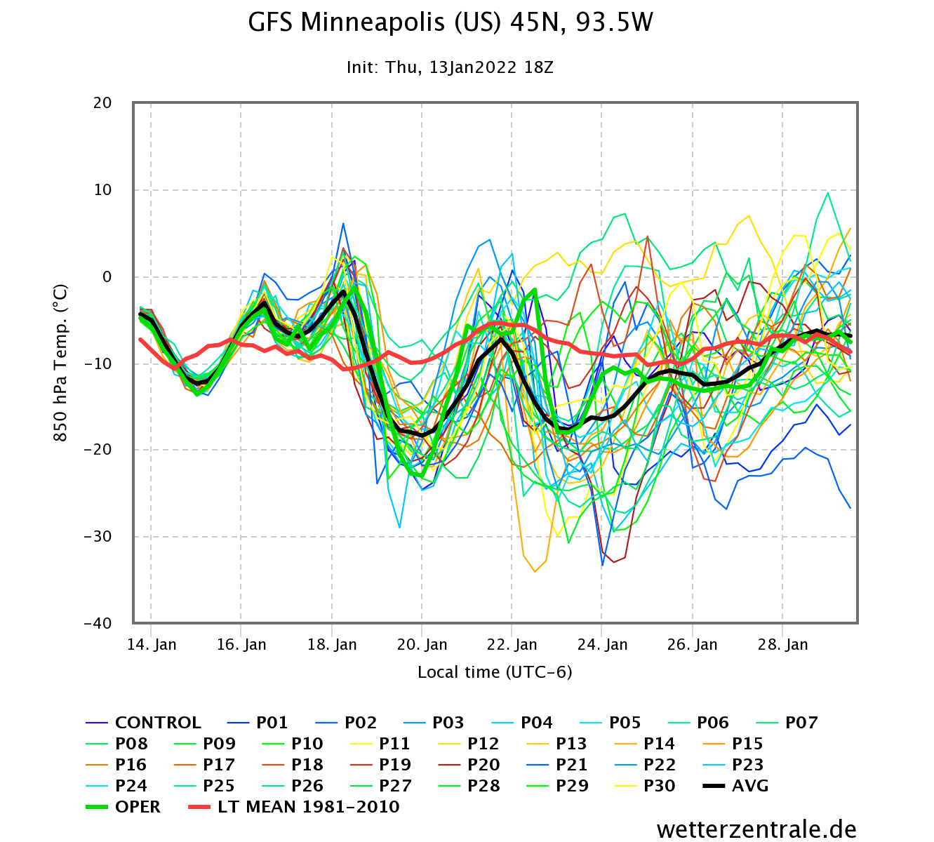
We can nicely see this cold train in the 16-day ensemble forecast below for Boston in the northeastern United States and Minneapolis in the Midwest as an example. The graph shows the temperature at the lower levels, where we can see individual cold outbreaks following, creating a “cold train”, due to the cross-polar flow weather pattern.

This is nicely captured below on the official NOAA/CPC 8-14 day forecast for the United States. Colder temperatures will prevail over much of the eastern half of the country, with western states having warmer than normal temperatures under the influence of the high-pressure zone.

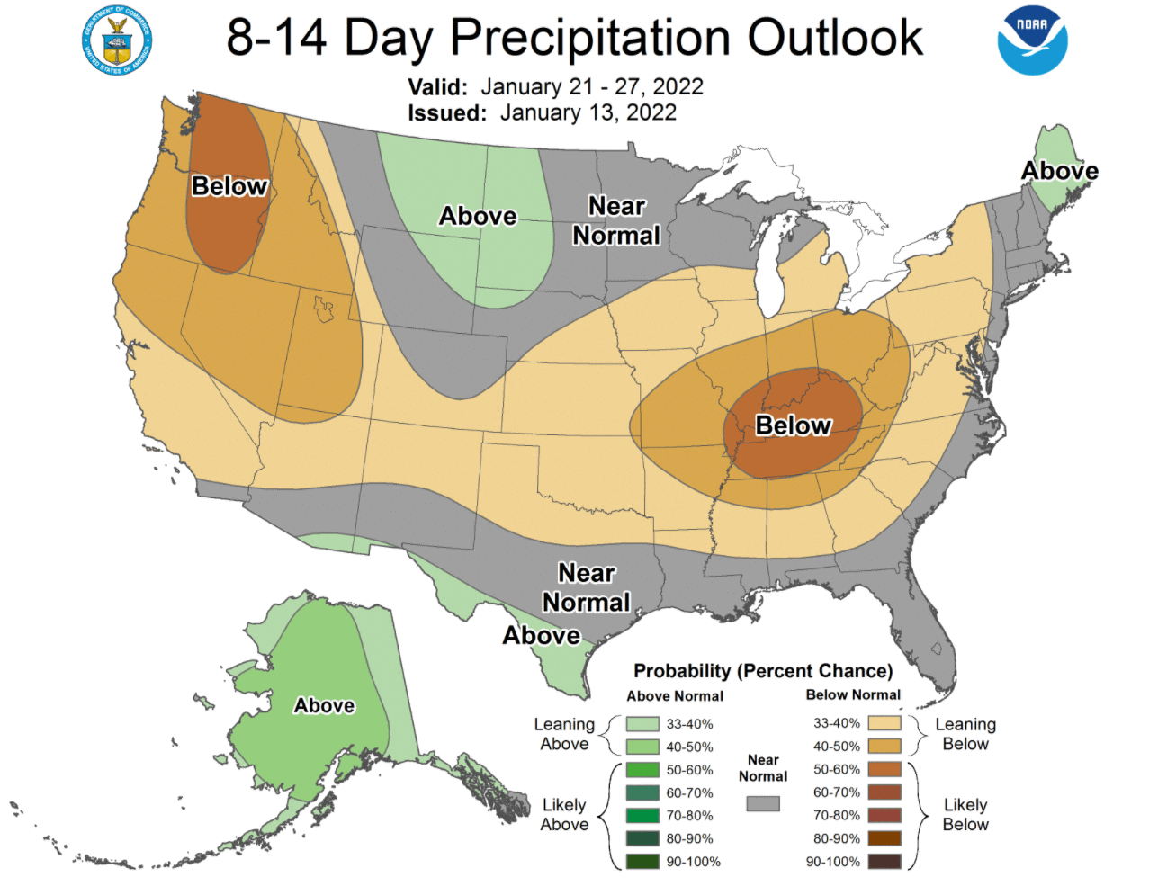
Looking at the official NOAA precipitation forecast, we have mostly drier than normal weather. In the west that is due to the higher pressure. Over the eastern United States, the drier conditions are due to the colder air being quite dry, also limiting any high amount of precipitation. We see some more precipitation over the north-central regions and the far northeast corner of the United States.
FEBRUARY POLAR VORTEX AND WEATHER
The latest extended-range forecast from ECMWF was just released, so we can use that to also look at some February trends. First, we need to look at the state of the Polar Vortex. Below is the forecast for the stratospheric part, which shows a strong character with a stable form and colder than normal temperatures.
The corresponding lower pressure pattern for early February shows the higher pressure remaining over the North Pacific and Alaska, reaching into the polar regions. A broad low-pressure zone remains over eastern Canada, with a gap down into the central United States. Lower pressure and colder weather are signaled over Europe.

The temperature forecast for North America shows this, with hints of colder temperatures continuing over the Midwest. This is a similar pattern as we are seeing now, with the “cold-train” from the north. But at this forecast range, we are just looking at trends, which means that most of the anomalies are hidden in the average.
Towards the mid-month, we are starting to see that the low-pressure area is closing out over eastern Canada and Greenland. This would mean the definitive end of the cross-polar flow and return of higher pressure into southern and eastern United States. A pattern like this can result when a strong polar vortex in the stratosphere takes over the entire polar circulation.

Temperature trends for this period show the return of warmer anomalies over much of the United States, and colder air pulling back north. This pattern however still permits occasional drop of cold air from the north, but not to a degree that it would be seen in the forecast average at this range.

But a much more interesting scenario is developing in the stratosphere towards the end of February. The ECMWF extended forecast is showing hints of a warming event occurring. This can lead to a polar vortex collapse, as the polar vortex is already weakening due to the sunlight slowly returning to the high altitudes over the polar regions.

This is worth monitoring as it can have a profound effect on the weather development into the Spring season. Speaking of which, we will now finish off by quickly looking at the latest seasonal forecast trends for the winter-spring transition period.
WINTER TO SPRING SEASONAL FORECAST
We have to note, that this EMCWF data was released earlier this month, and likely does not cover any potential stratospheric warming/collapse events. The long-range forecast covers the February-March-April (FMA) period.
That is evident in the long-range stratospheric wind forecast from the same data, which shows the above normal strength of the upper polar vortex. You can see the seasonal weakening of the polar vortex, but not many signs of a premature breakdown event. This image might look a bit different in the next update in early February.

Still, looking at the latest data, the strong high-pressure system in the North Pacific is still present in the forecast. That is likely to stay present well into the early Spring season, as it is driven by global large-scale processes. Notice the much lower pressure over Canada and Greenland, curving the jet stream into the northwestern United States and into the North Atlantic.
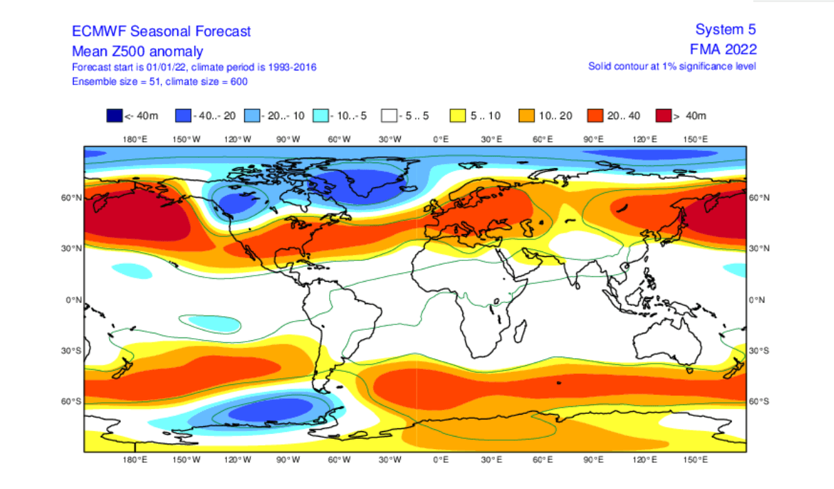
Lower pressure over Greenland helps to keep the jet stream more to the north, allowing an expansion to the high-pressure area to over much of Europe.
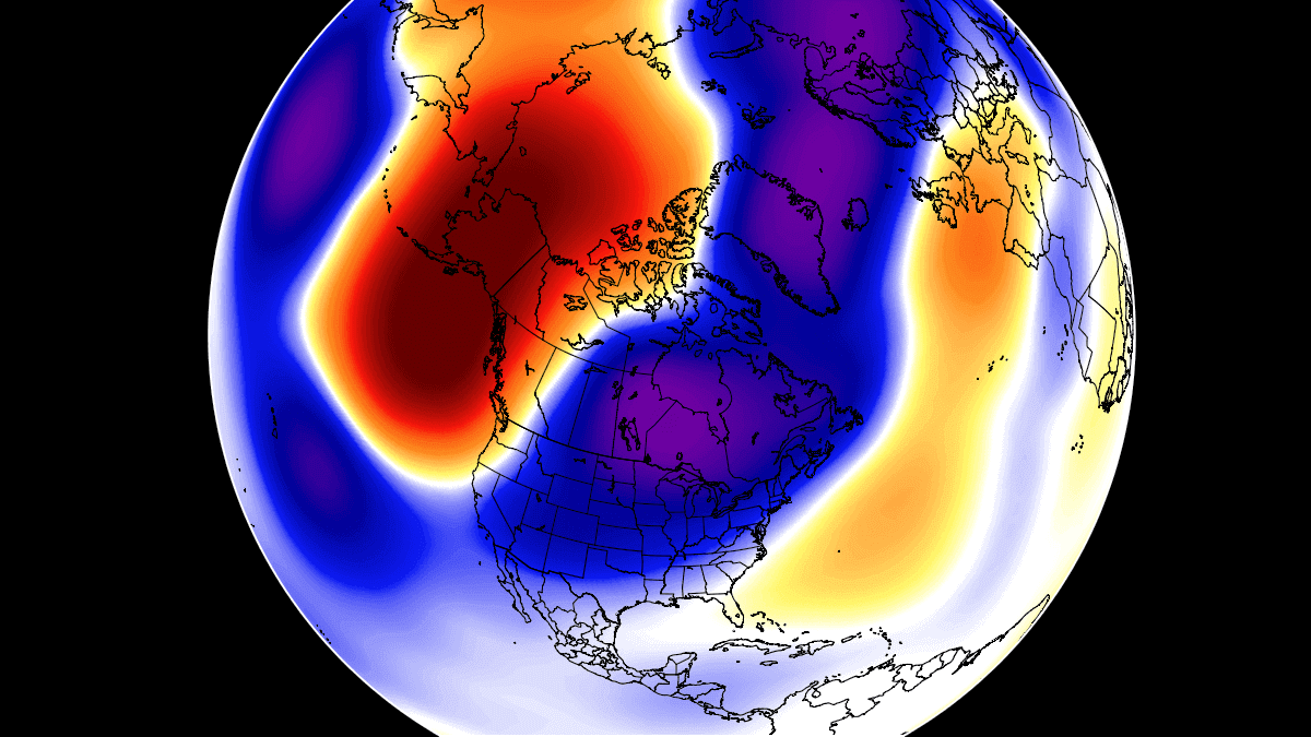
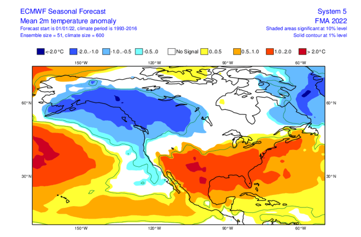
That is reflected in the global airmass temperatures, as we see a strong cold pool in western Canada. That has formed last month and is set to stay into the early Spring season. You can notice the warmer temperatures over much of Europe, which would suggest a pattern change to a more westerly flow into February 2022.
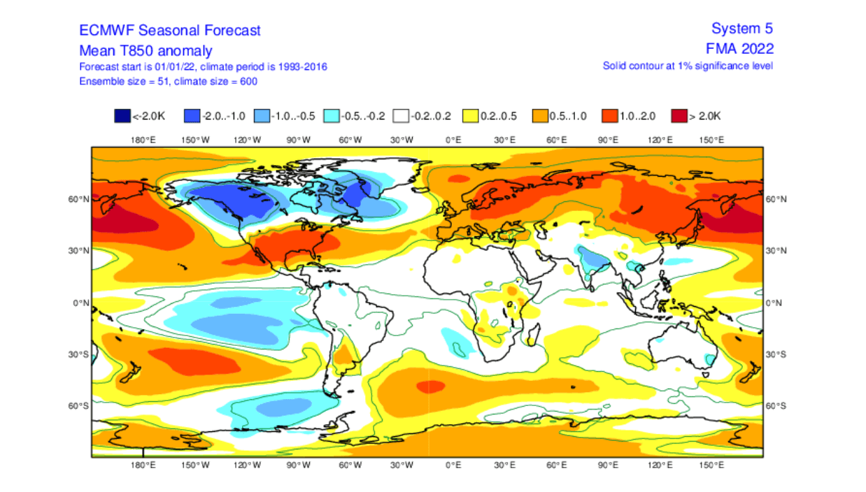
Taking a closer look at Europe, the surface temperatures are mostly above normal over the north and northeast. There is however a weaker warm anomaly over western Europe, suggesting that colder air intrusions can continue into western and parts of central Europe.
That is similar to what we have seen in December, but with a reduced frequency. These forecasts only show the prevailing or average picture over the course of 3 months, which typically contains a lot of sub-seasonal variabilities.

Over North America, we see the large cold pool in western Canada and Alaska. That comes from the north flow around the strong high-pressure zone in the North Pacific. In such a pattern, cold air can quickly spread into the midwest and the central/eastern United States, as was seen this month, with more to come, despite warmer than normal conditions being forecast in the seasonal average.
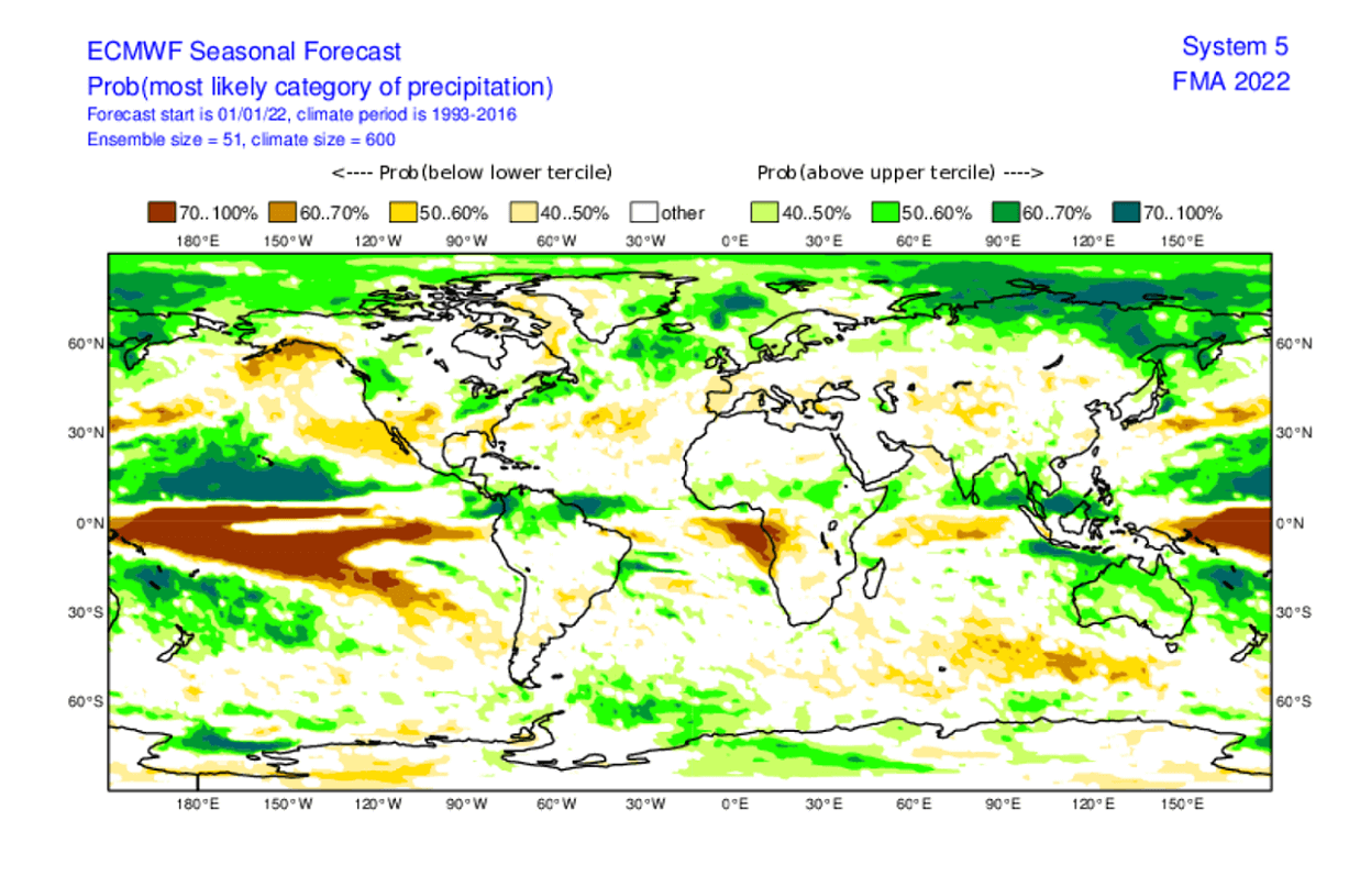
Looking quickly at the global precipitation forecast, we see mostly drier to normal conditions over Europe, under a high-pressure system, and wetter conditions in the north.
Over North America, more precipitation is forecast over western Canada, which is still mainly snowfall in this season. More precipitation is also forecast over the northwestern and northeastern parts of the United States. The southern United States is forecast to have normal to drier conditions.
As a contrast to the ECMWF model forecast, we are also adding the forecast from the CFSv2 model, run by the NOAA/NCEP in the United States. It shows a very similar pattern, with the large cold pool in western Canada, reaching down into the northwestern United States. The southern part of the country is also forecast to remain warmer than normal.
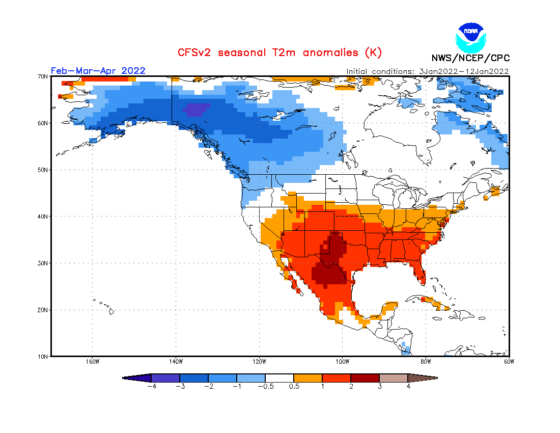
Precipitation forecast shows wetter conditions over much of the northern and parts of the eastern United States. In the northern parts of the country, most of the precipitation can still be snow form, due to the nearby cold pool in western Canada. That option slowly reduces as we go deeper into the Spring season.

We will release regular weekly and monthly updates on weather development, as fresh forecasts and data are available. So make sure to bookmark our page, and also, if you have seen this article in the Google App (Discover) feed, click the like button (♥) there to see more of our forecasts and latest articles on weather and nature in general.
SEE ALSO: