The June weather forecast shows a dance of pressure systems over the United States and Canada. We will start off with normal early June weather dynamics and warmer overall. But the second week will bring a strong pattern flip, with a low-pressure anomaly over the eastern United States.
A high-pressure area is forecast to build over the United States in the second half of the month, bringing warmer and drier weather to a large part of the country and also showing important heatwave potential.
As the meteorological spring has come to an end, we will first take a quick look at the atmospheric patterns for the past season. Then we will do a weekly forecast breakdown of the weather patterns over the United States and southern Canada.
SPRING COMES TO AN END
With June, the meteorological summer begins. Meteorological seasons are 3-month periods that separate the year into four seasons based on the temperature and weather patterns.
In the Northern Hemisphere, June-August is the warmest period of the year, while December-February is the coldest period, covering summer and winter, respectively. The two transition periods in between are spring and autumn.
So, as the meteorological spring comes to an end, we can first quickly look back at the weather patterns using the analysis data from the NOAA Physical Science Laboratory.
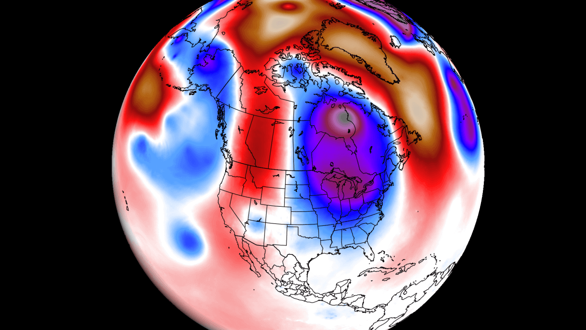
The image below shows the spring 500mb pressure anomaly. You can see a broad low-pressure area over the western United States and southwestern Canada. A high-pressure anomaly was present over the northeastern Pacific, and another high anomaly was over the eastern half of the United States and Canada.

A low-pressure area spins counterclockwise, which means it produces a southerly flow on its front (east) side and a northerly flow on its back (west) side. This usually means warmer air transport ahead of the low area and cooler air behind the low. This produces very different weather patterns across the western and eastern parts of the United States and Canada.
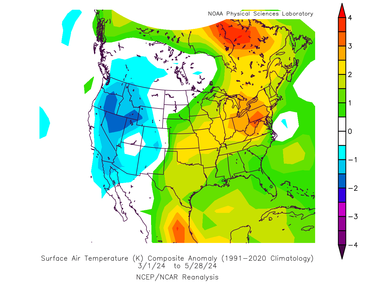
Below is a temperature anomaly analysis, which shows the effect of the low-pressure area over the west, bringing cooler air down from the north. Warmer-than-normal temperatures were present over much of the central and eastern United States and eastern Canada under a southerly flow.
Pressure patterns also drive precipitation. The analysis below shows that there was more precipitation across the eastern half of the United States, especially over the south and southeast. As mentioned, a low-pressure area spins counterclockwise. That means a low out in the western United States brings a lot of warmth and moisture into the south-central and eastern United States, depending on its exact location.

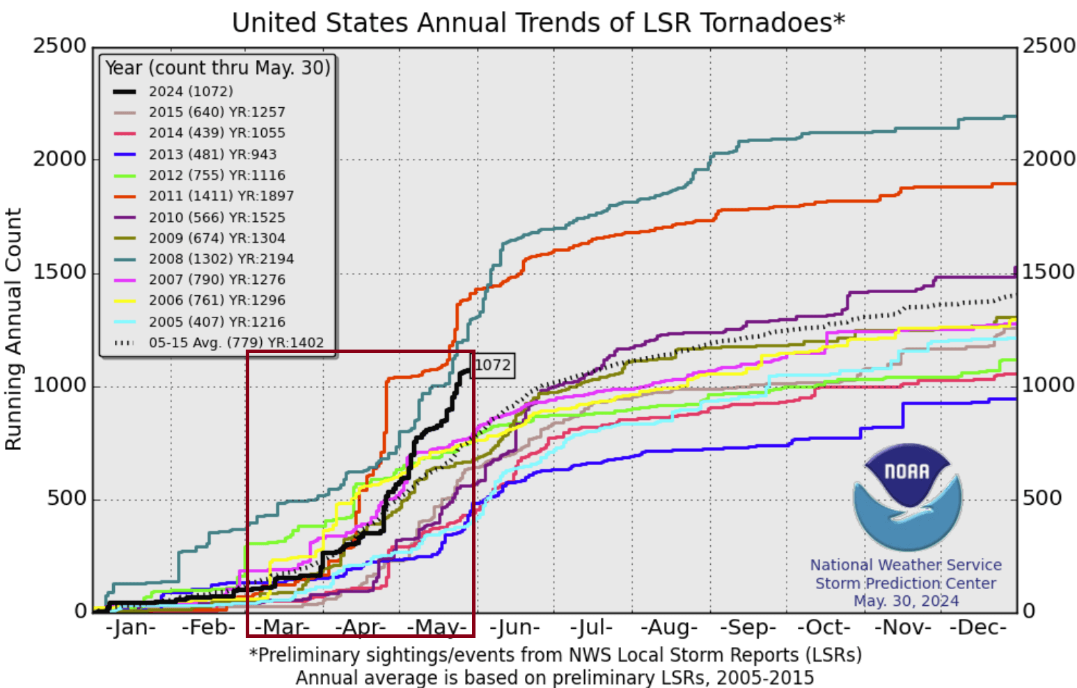
Warm and moist air is unstable and acts like fuel for thunderstorms. The graph below shows the preliminary tornado events over the United States so far in 2024. Marked is the spring season, with over 900 reported events, which is above average for this period. It was largely driven by the low-pressure area in the west, bringing unstable airmass into the south-central and eastern United States.
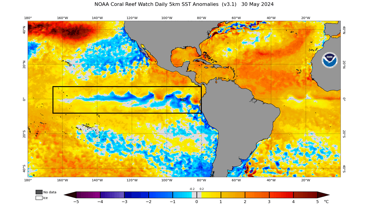
One of the drivers behind the spring weather patterns was the weakening El Niño anomaly in the Pacific Ocean. El Niño is the warm ocean phase in the tropical Pacific. But in the latest analysis below, you can see this region starting to shift into a cold phase called La Niña.
In the video below, you can see the spring shift from the warm ocean anomalies into more cold areas starting to appear. This was the rapid breakdown of the warm ENSO phase.
This is a new cold ocean ENSO phase that is currently developing. It will become more important for weather patterns as we move into summer and especially later towards winter. We will cover this in more detail in our upcoming ENSO update article, but we wanted to mention this important factor as its a big weather driver in 2024 so far.
WEATHER IN THE NEW MONTH
We will look at the June weather trends using the latest ensemble guidance from the ECMWF forecasting system. Graphics are provided by weathermodels.com using a commercial forecasting license and from TropicalTidbits.
Looking at the pressure anomaly forecast for the first week of June, you can see a low-pressure system over southwestern Canada, extending into the northern United States. This is a 5-day average, so we do see indications of the low pressure starting to extend further down into the central United States.
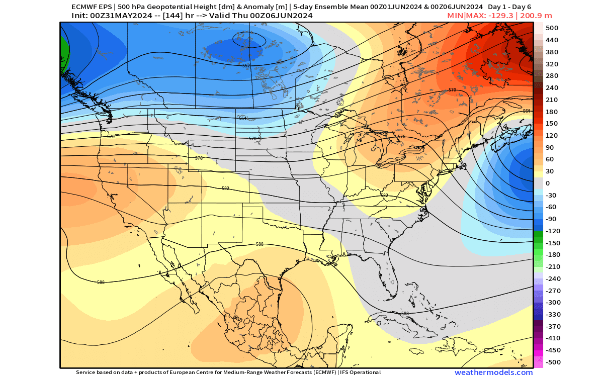
As pressure systems usually work in pairs, we have a high-pressure anomaly over the southwestern United States and another ridge over the upper Midwest and the northeastern United States.
Looking at the temperature forecast for the same period, you can see the cold anomaly over southwestern Canada and the Pacific Northwest, associated with the low-pressure area. Warmer weather is forecast under the high-pressure anomalies over the southwestern and northeastern United States, upper Midwest, and eastern Canada.

A normal to cool temperature anomaly is shown over the southeast as a weather disturbance moves out over the region and towards the Atlantic.
Early next week, daytime temperatures will reach over 90 degrees across the deep South and the southeastern United States. The central plains, California, and the Midwest will see temperatures over 80 and into the 70s over New England and southeastern Canada.
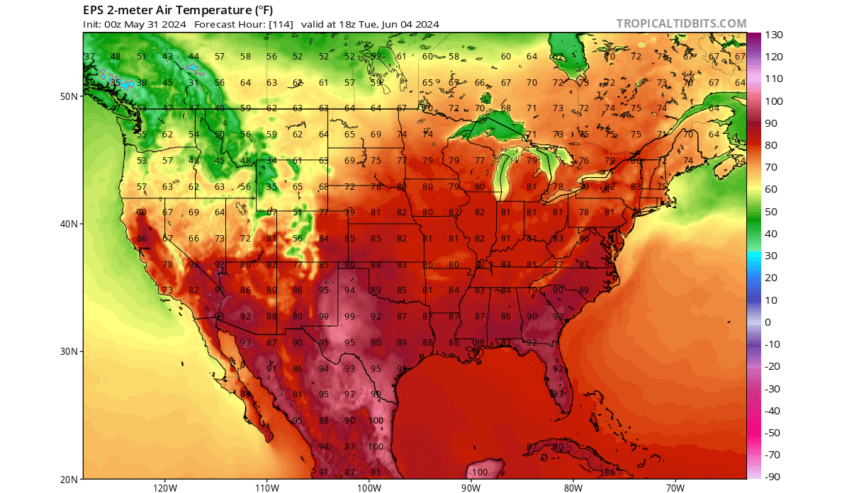
Another story is over the northwestern United States, with temperatures dropping into the 50s and low 60s, under the influence of the low-pressure over southwestern Canada.
Looking at the precipitation, you can see a rainfall anomaly over parts of the south/southeast and across the Midwest. This is associated with the passage of a surface low-pressure disturbance over the south and with the growing influence of the low-pressure over Canada.
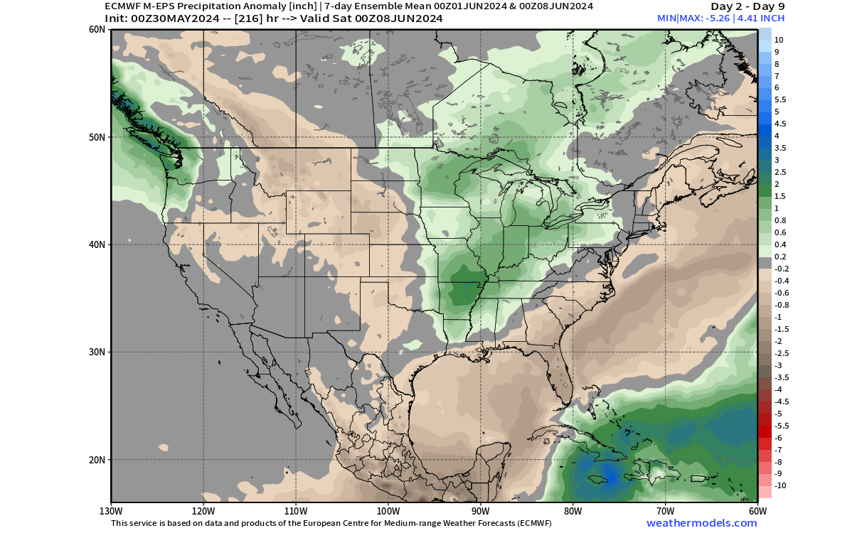
Less rainfall than normal is expected over the far southeastern United States and the western half of the country, with the exception of the Pacific Northwest.
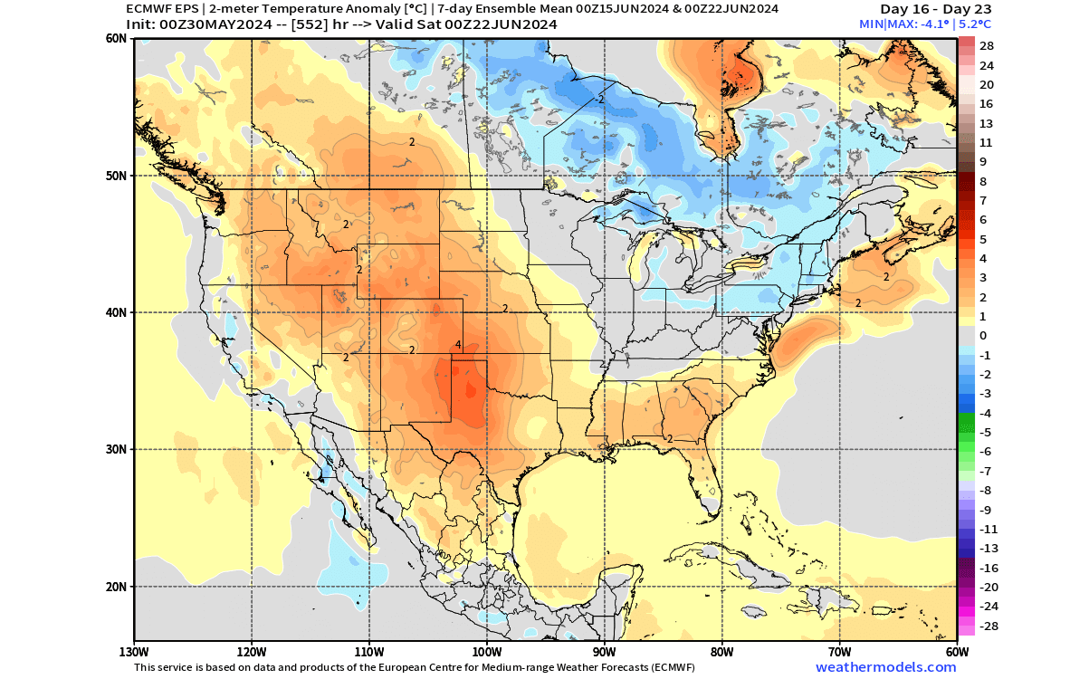
THE SECOND WEEK OF JUNE
The weather pattern is expected to drastically change during the second week of June. The pressure anomalies below show a big change in the pattern. A broad low-pressure area is starting to take over the eastern United States and southeastern Canada, with a strong ridge rising in the west.

This is a more winter-type pattern, which usually brings snowfall across the Midwest and the northeastern United States and cold across much of the eastern half of the country.
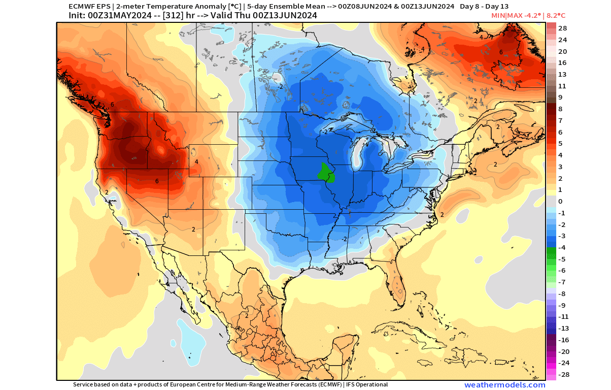
Looking at the temperature forecast for this period, below-normal temperatures cover the entire Midwest and extend into the southern United States. Much warmer than normal temperatures are forecast over the northwest, New England, and eastern Canada.
But as we are not in winter, the cold anomaly does not mean freezing temperature, but it just means lower than normal for this time of year. Below is an example of daytime temperatures on June 9th, the start of the second week.
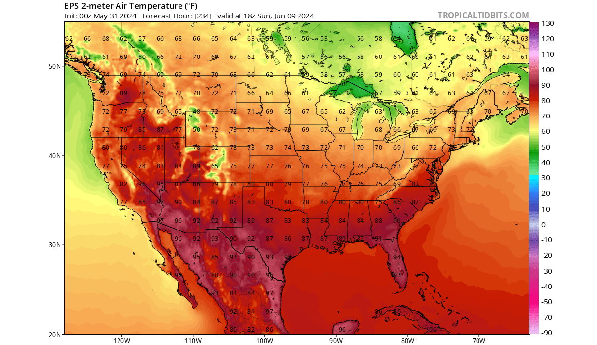
You can see the temperatures in the 60s over the upper Midwest. This is not “cold” by any means, but it is lower than normal for this time of year. Above-normal warmth is forecast to spread into the northwest, with temperatures into the upper 80s.
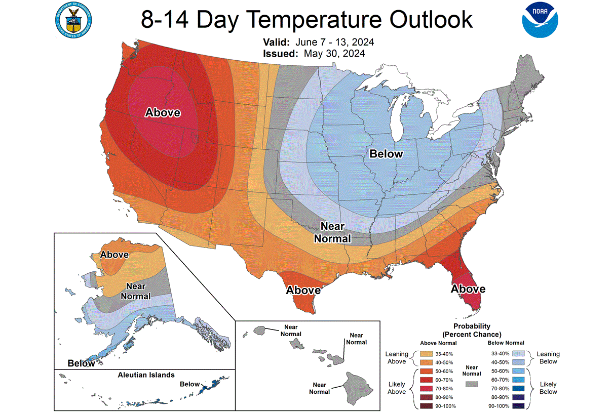
The official 8-14 day temperature outlook also shows below-normal temperatures forecast for the Midwest, while warmer-than-normal weather spreads under the high-pressure system in the western United States.
Finishing off with precipitation, the rainfall anomaly forecast shows that a cooler airmass also brings drier air. Less rainfall is forecast over the northern United States, the upper Midwest, and the south. More rain is forecast over the northeastern United States and eastern Canada on the front edge of the low-pressure system.
EXTENDED RANGE WEATHER
Going into the second half of June, we are entering the extended-range forecast. This means that we are just looking at the latest trends. Despite the success these forecasts had in previous months, these are not fixed weather scenarios.
The latest extended forecast for the third week of June shows the low-pressure anomaly over the eastern United States moving out into eastern Canada. The high-pressure ridge from the west will progress further east into the central United States.
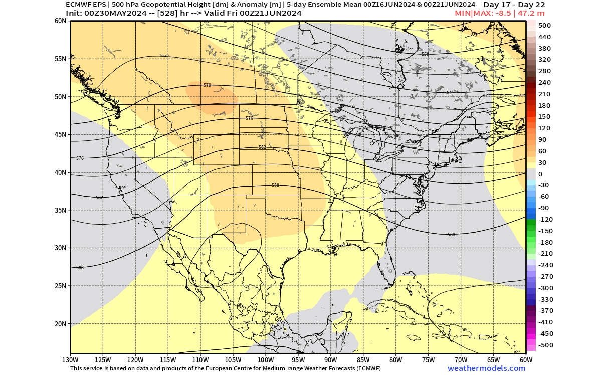
In the temperature forecast, the cool air anomaly is seen moving out into southern and eastern Canada and also passes over the northeastern United States. The warmer air, along with high pressure, is forecast to spread from the west towards the central and southern United States.
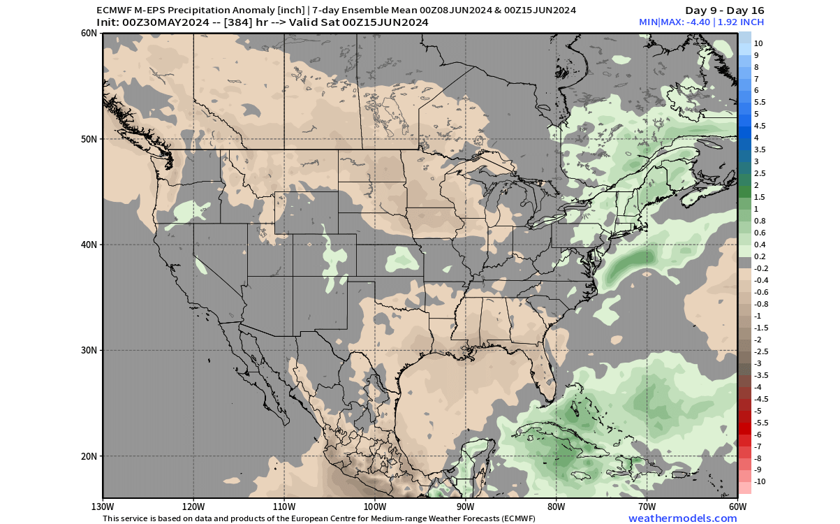
The precipitation forecast shows more rainfall following the movement of the low-pressure area around the Great Lakes, the northeastern United States, and eastern Canada. The central and southern United States show a trend of less rainfall, due to the high-pressure anomaly bringing a more stable weather pattern.

Precipitation is also dependent on moisture and clouds, which are much harder to forecast than temperature patterns. So, for that reason, the precipitation forecast shows a decreasing signal as we go further out into the forecast range.
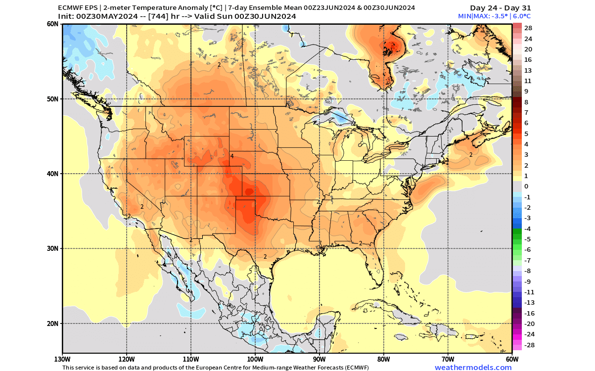
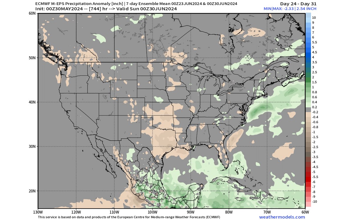
WEATHER IN THE LAST WEEK OF JUNE
Weather forecasts show that a large high-pressure anomaly over the United States will expand further east in the last days of June, centering over the Midwest. This brings a more stable, warmer, and drier airmass into the United States and southern Canada.

In the temperature forecast, we can see a broad warm anomaly, indicating above-normal warmth over much of the United States, apart from the northeast. The southern United States and the south-central Plains currently show the biggest heatwave potential in this period.
The precipitation forecast shows less rainfall over the southern and central United States, and southern Canada. This is because a high-pressure anomaly also brings along a more stable and drier airmass.
We will keep you updated on the weather pattern development in the coming weeks and months, so don’t forget to bookmark our page. Also, if you have seen this article in the Google App (Discover) feed, click the like button (♥) there to see more of our forecasts and our latest articles on weather and nature in general.
Learn more: