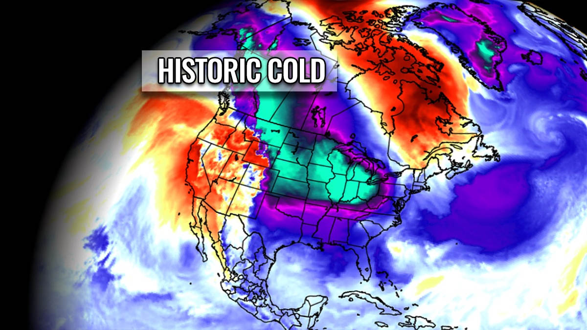
An Arctic cold outbreak is forecast to plunge from Canada into the United States just a few days before the Christmas holidays. A potentially historic cold with frigid air mass will send millions across the Plains and Midwest into deep freeze, reaching deep South and Southeast U.S. The Arctic blast will lead to a major winter storm that could become a bombogenesis cyclone and blanket Great Lakes and Northeast with deep snow and blizzards around Christmas.
IMPORTANT UPDATE: Millions across North America will face Deep Freeze and the Coldest Christmas in Years as Powerful Storm Elliot develops this week
So far, the winter season across North America has been pretty cold, thanks to much colder than normal weather in Canada since mid-November. The upcoming event will lead to near-record or even historic cold temperatures by mid-week into the holiday weekend. The cold air is forecast to spread far south, reaching the Gulf Coast and Southeast.
This will lead to the coldest temperatures so far this winter season 2022/23, for many.
A significant weather change will happen just days after the major winter storm Diaz brought blizzards and a huge amount of snow to Dakotas. The satellite image below reveals an impressive winter storm centered over Nebraska on Tuesday, with northern Plains under a comma cloud shield where the most intense winter weather normally develops.
Strong pressure and temperature differences lead to strong winds that combine with heavy snow, leading to intense blizzard conditions, low visibility, and difficult driving conditions.

The Black Hills town of Deadwood received more than 4 feet of snow. A typical occurrence when high moisture is being advected into higher terrain is known as orographic snowfall.
The snow blizzard was intense across both Dakotas, with South Dakota being the worst hit. Tens of roads, including part of Interstate I-90, were closed by massive snow drifts and blowing snow.

This weekend, a strong jet stream (high-level winds aloft) racing across the central parts of the Contiguous US will shift from westerly to more northwesterly. This will allow a large pool of extremely cold air mass in west-central Canada to plunge toward the southeast.
Temperatures are already very cold across Canada, with many under frigid cold mornings around -20 to -30 degrees F. Those will gradually begin spreading south on Monday while plunging into low -40s F across southern Canada before the Arctic outbreaks turn for the United States.

With the more meridional, north-northwesterly flow establishing aloft, much colder weather and low windchills will also reach Texas and parts of Florida late next week. Expect Christmas holidays to be bitterly cold this year, forecast to persist towards the New Year.
This video animation forecast below hints at the impressive spread of the frigid Arctic cold temperatures from central Canada deep south into the United States in the final days before the Christmas holidays. The temperature anomaly is particularly intense even for December, with airmass nearly 30 degrees colder than usual across the nation.
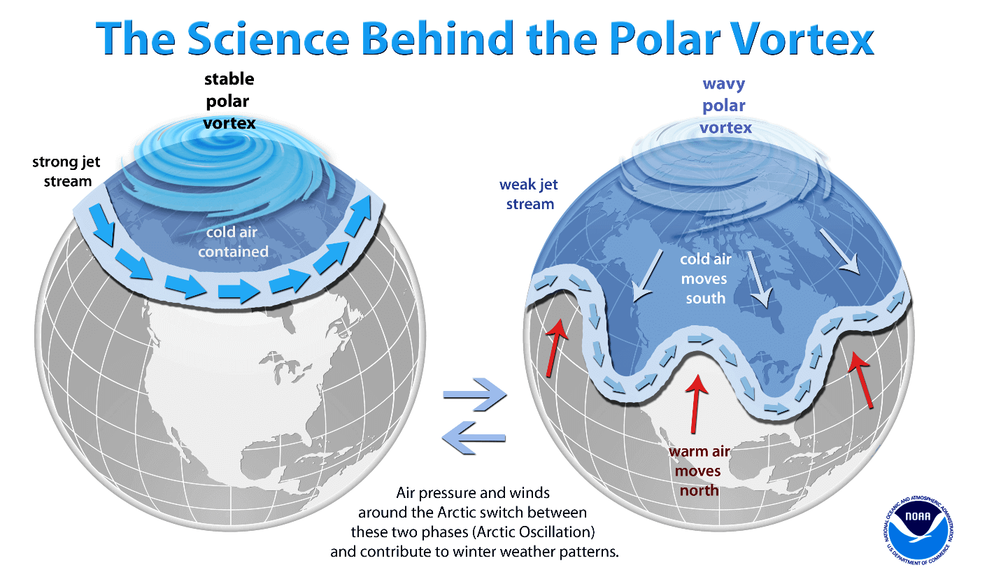
Meanwhile, the Polar Vortex circulation aloft remains quite powerful this winter. As will be discussed below, its coldest part sits over Arctic Canada this December. This feature plays a major role in winter, sending cold outbreaks and snowstorms across the northern hemisphere.
THE POLAR VORTEX ABOVE US
As we know, our atmosphere has several layers around the Earth. Most of the weather dynamics for all life on our planet occur in the lowest two, the troposphere and the stratosphere above.

The troposphere layer, where we live, is the lowest. All the weather changes take place here. The troposphere layer extends from the Earth’s surface (known as the sea level) up to 12 km high. Its depth varies from 8 km to nearly 20 km. It is the deepest above the equator but gets thicker above both poles.
Above this layer is a much deeper one known as the stratosphere. A stratosphere layer is about 12-50 km thick and very dry there. The Ozone layer, vital in protecting our planet, is also found in the stratosphere.

Our weather has one very important feature in the stratosphere for all the dynamics. It is the Polar Vortex. The polar Vortex is an enormous, three-dimensional ring of potent winds. Located about 20-50 km above the Earth’s surface. It surrounds the North and South poles and is the strongest during winter.
The troposphere and the stratosphere layers are particularly crucial for Earth’s climate because the vortex covers most of the bottom half of the atmosphere, from the Earth’s troposphere up into the stratosphere. Thus having an important role in the winter weather across the high and mid-latitudes.

As the vortex spins high above our troposphere, it is still directly connected to the lower part where we live. The Polar Vortex shapes our daily weather in many ways. It works as one sizeable hemispheric circulation.
But how it forms?
The Polar Vortex has seasonal differences and is the strongest during the winter, as we learned. When we head into the autumn months, the polar regions receive much less sunlight over time due to the inclination of the Earth’s axis. Leading to the north pole into a position where it starts cooling down faster.
Although the poles are getting cooler with time, the atmosphere further south is still warm. Those receive much more sunlight and energy from the Sun than polar regions.
As the temperature falls over the polar regions, it also lowers the pressure. A similar process occurs in the stratosphere layer above. As a result, the temperature difference between the North pole and the equatorial region increases. A large low-pressure (cyclonic) circulation develops across the polar stratosphere.

We can put all these details together. Therefore, the Polar Vortex is a very large cyclone, covering the whole north pole. The same occurs in the southern hemisphere, extending south to the regions in mid-latitudes.
This chart above hints at a typical example of the Polar Vortex set at around 30 km (18 miles) altitude during the winter. It represents the powerful jet stream rounding the vortex inside.
When we discuss its behavior, we generally look at 10 mbar level charts.
MAJOR WINTER STORM LEADS TO THE COLDEST AIR OF THE WINTER SEASON 2022/23
Next week, the developing weather situation across North America will form a dipole weather pattern. With High over the northern Pacific and western North America, releasing a significantly deep upper trough on it east. Plunging from Canada south into the United States with Arctic cold airmass following in its wake through days before the Christmas holidays.
The chart below shows the 500 mbar upper-level low across the States. It will drag the air far south as it progresses toward the East Coast next weekend.

Typically, a high surface pressure system develops beneath such intense blocking High aloft. It will spread across much of western Canada and the United States for the rest of this month, persisting for nearly two weeks. The deep low (surface cyclone) seen beneath the core of the Polar trough to its east then leads to a strong pressure gradient.
Ahead of the Arctic blast, a new Winter Storm, its name could be Elliot, will develop. Giving a large pressure difference between the northern Plains and western Canada (1060 mbar) against the developing surface cyclone over the Great Lakes (980 mbar). A more than 70 mbar difference. Just by looking at the isobars (lines connection equal pressure) on the chart, one can judge gradient will support severe winds from the north.
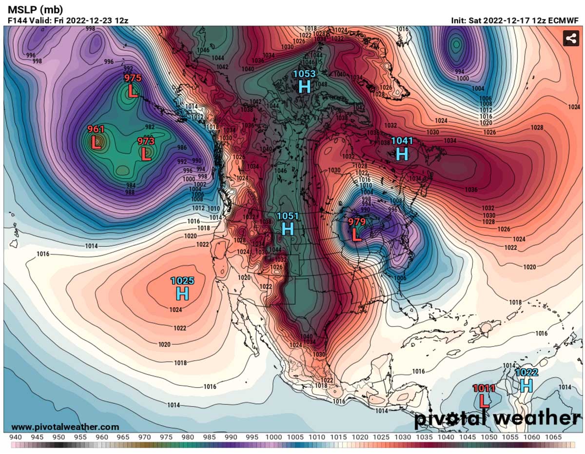
The surface pressure might also challenge some historic values across the northern Rockies and Northern Plains, as well as in southern Alberta, Canada, early to mid-week. Montana’s high-pressure record is 1064 mbar, while some models hint at even higher pressure that could be measured during the peak of the High across on Thursday or Friday.
These enhanced winds will lead to a massive transport of a very cold Arctic air mass from west-central Canada into the central part of North America. Southern Canada and most of the CONUS will be at the core of this blast. The flow is forecast to be pure meridional so that the general winds will follow a pressure pattern, blowing from High toward Low.
The colder-than-normal Arctic air mass will gradually spread east-southeastward from southern Canada prairies from Monday to mid-week. Putting regions from the northern Plains Midwest into a deep freeze. Air mass will continue south before Christmas, reaching Texas, Gulf Coast, and Florida.

This huge cold pool associated with the new winter storm Elliot will be the coldest of the winter season 2022/23 so far for Alberta and Saskatchewan, Canada, as well as for the Dakotas, part of the Midwest, Mississippi Valley, and the Gulf coast late next week.
EXTREMELY COLD TEMPERATURES WILL SEND MILLIONS INTO DEEP FREEZE AFTER WEDNESDAY
Daytime temperatures are forecast to stay below 0 °F in Montana and North Dakota on Monday and below -10 on Tuesday. While afternoon temperatures across South Dakota, Minnesota will stay a few degrees below 0 on Tuesday. Below-freezing all day across Midwest to Great Lakes.
With strengthening pressure across the north, the Arctic front will begin its plunge down the Front Range of the Rockies in Colorado and Wyoming on Wednesday, spreading through the central Plains. The bitterly cold air mass will nosedive temperatures across the south-central Plains on Thursday, spreading to the rest of the Southeast and Florida into Friday.
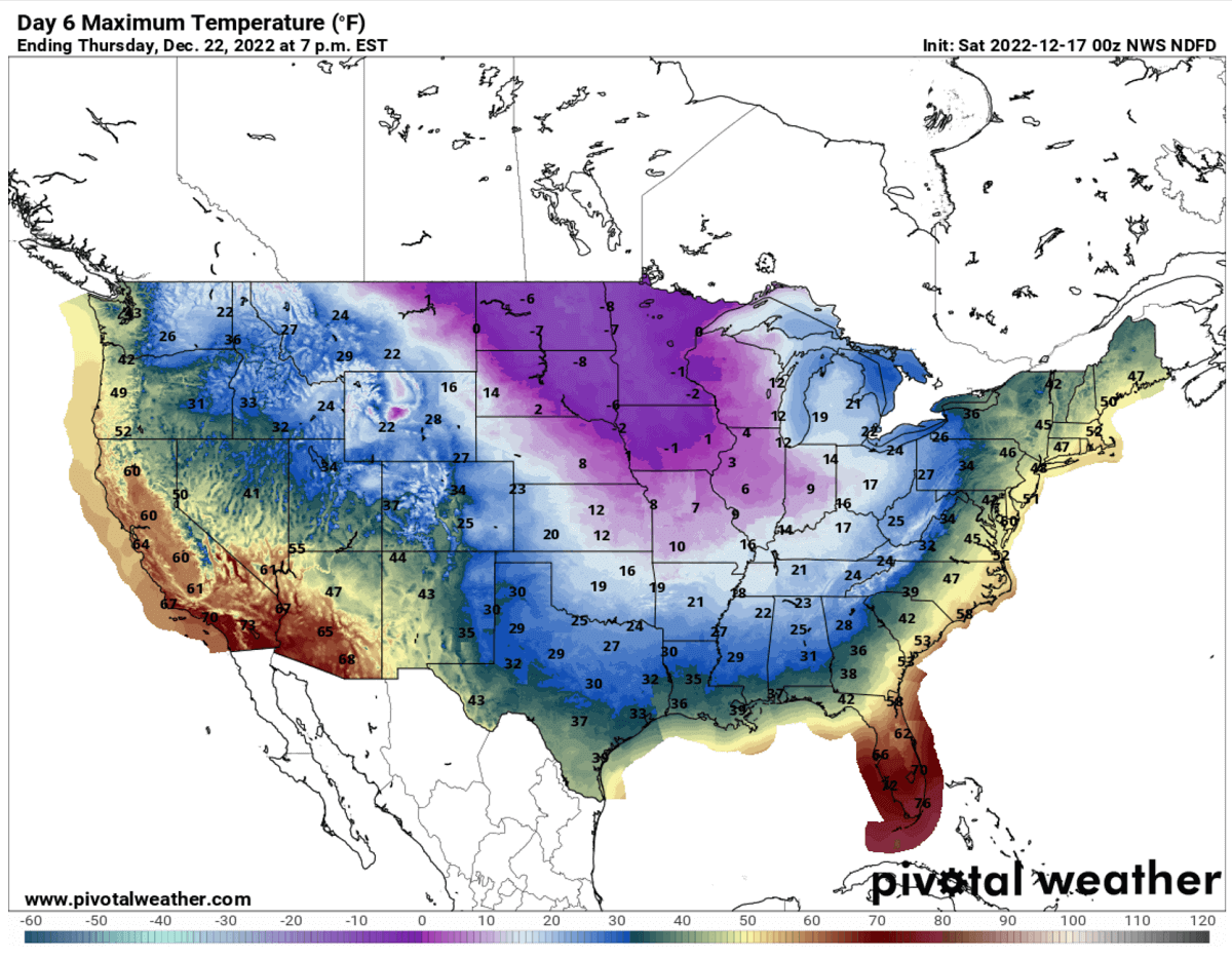
Much colder days will be Wednesday and Thursday, with nearly two-thirds of the country staying below freezing all day. The worst cold with daytime Highs in the -10s F across Upper Midwest. Thursday afternoon temperatures will rise only slightly above freezing across central Texas, the lower Mississippi Valley, and the Southeast United States.
Strong northerly winds beginning early Wednesday will bring extremely low wind chills across the Plains. Real feel temperatures will be below -30 °F, much lower, around -50 °F across the north (Montana, Dakotas), with the threat of frostbites for those exposed outside.

Thursday and Friday mornings will bring frigid cold for most Lower 48, with below-freezing also in deep south Texas and central Florida. Before, central Florida will experience the mid-70s on Wednesday and the upper-60s on Thursday afternoon.
Friday will not warm up more than to the low 50s as the core of the Arctic blast turns towards the East and develops a new winter storm Elliot.

WITH A WINTER STORM DEVELOPING OVER THE LAKES, ARCTIC BLAST SENDS EAST COAST INTO EXTREME COLD FOR CHRISTMAS
Progress of the pattern over the Contiguous US late next week will result in the deepening core of the Arctic blast. Beginning Thursday, a significant dipole weather pattern develops, strengthening High on the west and a deepening Low on the east. The core will be very deep.

The bitterly cold weather will persist into the Christmas holiday weekend and spread farther east. With 30 to nearly 40 degrees lower than average temperatures for the eastern two-thirds of the country.

Even Florida will see around 25-30 degrees Fahrenheit colder than average temperatures. At the same time, the cold father north across Upper Midwest, Ohio Valley, and the Great Lakes will remain frigid for several consecutive days, more than 40 degrees below normal.
We often use the mid-term Meteogram charts to understand how anomalous are the temperature forecasts when a significant Arctic outbreak occurs. Attached below is a 4-chart image for Dickinson (ND), Dallas (TX), St. Louis (MO), and Washington, D.C.
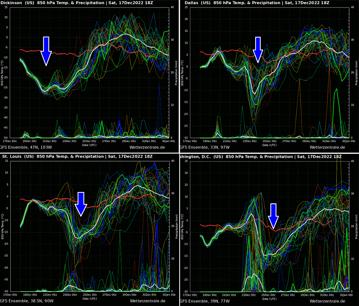
The chart for North Dakota reveals that the new Arctic blast will be very strong, around 20 degrees C below average, which is particularly extreme for the northern Plains that are used for extremely low temperatures during winter. The other three charts represent the arrival of the Arctic cold core late Thursday into Friday and Washington D.C. on Saturday.
As we see, temperatures will push many states into deep freeze, much lower than were experienced over the last two weeks. Thanks to the winter storm rapidly developing over the Lakes, this cold will bring the coldest weather of the winter season of 2022/23. Based on the Meteogram forecasts above, the cold pool will be the most persistent in the north.
WINTER STORM LEADS TO A NEW LAKE-EFFECT SNOW EVENT FOR THE LAKES ONTARIO AND ERIE
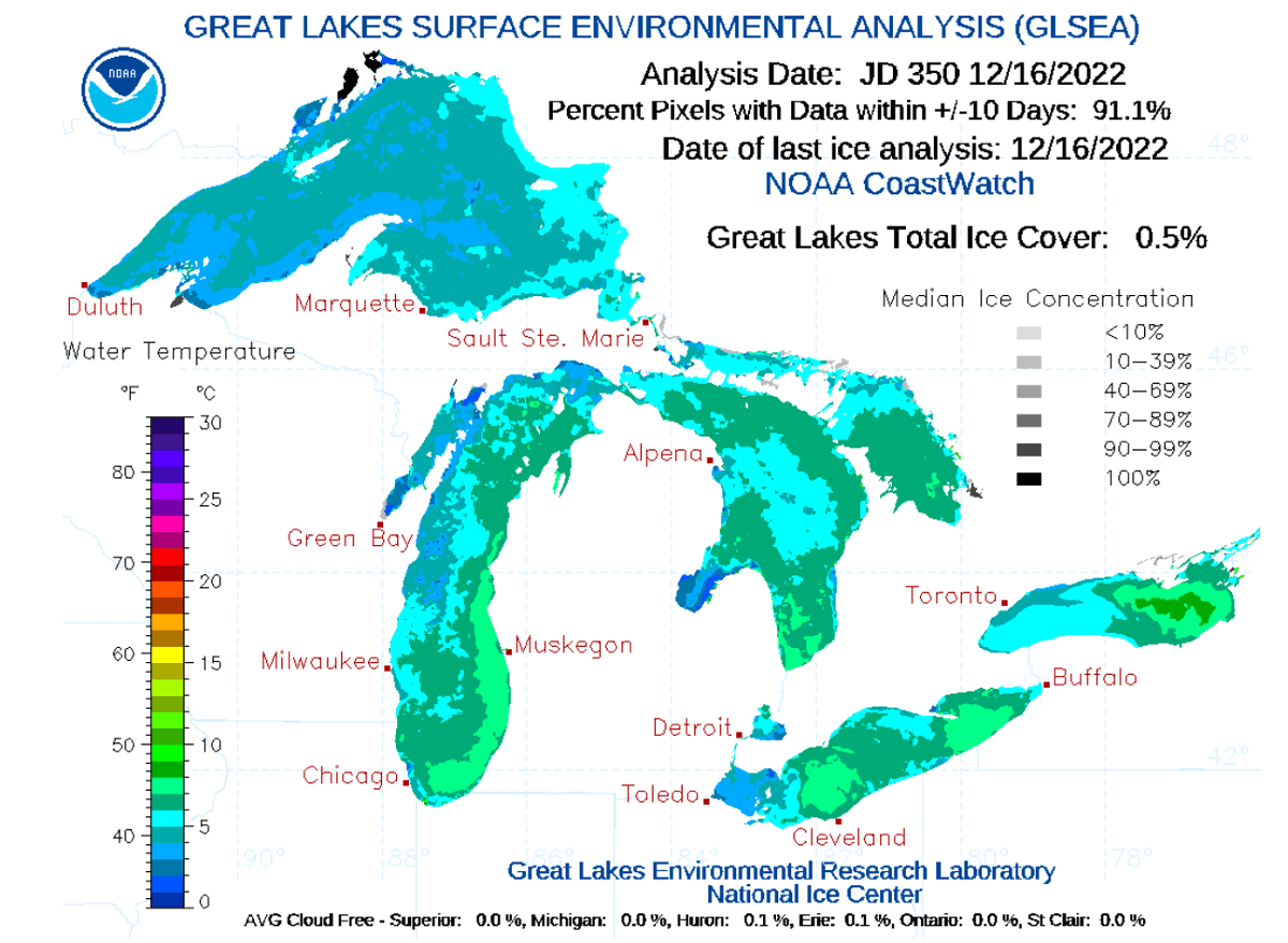
During the winter, very cold air mass travels from Arctic Canada towards the southeast. And it spreads across the Great Lakes quite frequently. This effect cools down the lake’s water and leads to freezing. So far this winter, the lake’s surface has yet to freeze, as NOAA reported, as it is still relatively early in the winter.
The lakes measure only about 0.5 % of the total ice cover as of this weekend, December 16th.
So, until the ice coverage doesn’t increase significantly, the Arctic cold blasts are forecast to develop lake-effect snow across the Great Lakes. The more ice-free the Lakes waters have, the higher potential is for the lake-effect snowfall. Including its intensity as thundersnow could also occur, as we could remember from the most recent historic Buffalo snow event two weeks ago.
The lake-effect snow is common across the Lakes region during the late fall and early winter months. It occurs when very cold air, often originating from Canadian Arctic, moves across the waters of the Great Lakes. And the snow deposits strongly depend on the general wind direction.
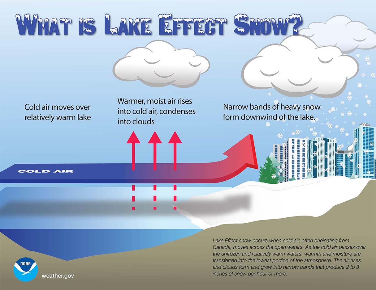
As the winds are blowing cold air mass over the unfrozen and always warmer waters of the Great Lakes, the combination of coming air, warmth, and moisture are transferred into the lowest portion of the atmosphere. Thus causing the air to rise and form clouds. Those begin to grow into a narrow band that produces heavy snow bands with 3-5 inches of snowfall rates.
The key component in the lake-effect snowfall process is the wind direction determining which areas will receive the heaviest snow. The highest intensity typically occurs in very narrow bands and snow squalls. So, it may fall in one location while the sun may be shining just a mile away in either direction of the snow band.

This weekend, the lake-effect snowfall was already underway, associated with cold in the wake of the departing winter storm Diaz. But the forecast intensity of the Arctic cold and wind direction associated with the upcoming new winter storm will trigger another significant round of lake-effect snow lake next weekend.
The chart above shows that the new blast of cold air and west-northwesterly winds over the Lakes will develop significant amounts of snow for all the lakes. Again, areas south of Buffalo and Watertown, New York, are forecast to dump a lot of snow. After this weekend’s 10-20″ snow, more snow will likely follow with a storm next week.
Stay tuned for further updates on the developing winter storm Elliot which will more likely become a rapidly developing surface low around Christmas weekend. The general weather model consensus agrees with the significantly deepening pressure once the core of the Arctic blast arrives. Still, the exact location is yet to be determined in the upcoming days.
Windy, Pivotalweather, and Wxcharts provided images used in this article.
SEE ALSO: