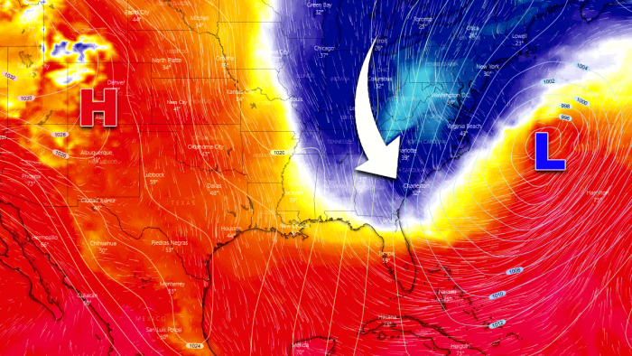
Ustable pattern has been dominating a large part of North America lately, but resulting in cold outbreaks towards the East Coast. Now, another cold blast is forecast early this week, with frosty mornings for the Southeast. Just a day after the first bomb cyclone of the season hit New England, this new system will develop another bombogenesis aftern ejecting the eastern United States. An intense snowstorm is forecast to blast across Nova Scotia and Newfoundland on Wednesday.
It has been quite an intense cold outbreak across the eastern United States last week, and now, another system will emerge over the southeast and rapidly intensify into the bomb cyclone while moving off the Atlantic coast this week. An intense winter storm is forecast to hit Nova Scotia and Newfoundland on Wednesday.
In the wake of this strengthening storm, another cold blast is expected to push into the East Coast and the Southeast United States. Much colder weather than normal will spread deep south again, reaching Florida as well.
Frosty mornings will result across the region, and frost will again be possible in northern Florida on both Tuesday and Wednesday. As the blocking high strengthens from the western CONUS through mid-week days, conditions will improve and warm up again after Wednesday.
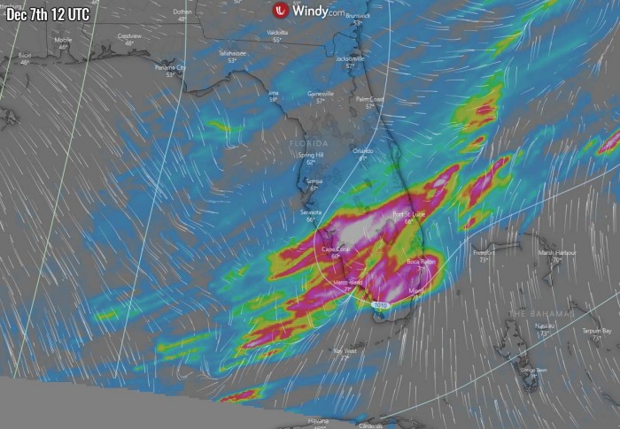
The frontal passage on Monday will spread across Florida, and some severe weather will be possible across the southern portions of the peninsula. The animation below is showing the storms moving the the Florida peninsula:
Let’s get into some more details on the pattern evolution in the coming days…
WARM TO THE WEST, COLD BLAST INTO THE EAST COAST
Despite the overall weather pattern across the North American continent is dominated by a strong ridge across the western and central parts, eastern Canada and the United States experience cold outbreaks from the north.
This is quite typical for such a pattern, as blocking to the west favors outbreaks of Arctic cold air mass towards east-southeast on its eastern flank.
Monday, Dec 7th
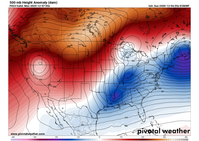
The pattern on Monday hints at how strong the upper-level ridge actually is over Canada and the western CONUS. We can notice there is a short-wave trough emerging into the Southeast United States.
Actually, one trough is moving across the Deep South while another wave is emerging from the north. Both will collide over the Southeast and begin strengthening as one system, moving east.
Notice the is still the first Northeaster’ (bomb cyclone) visible over Nova Scotia.
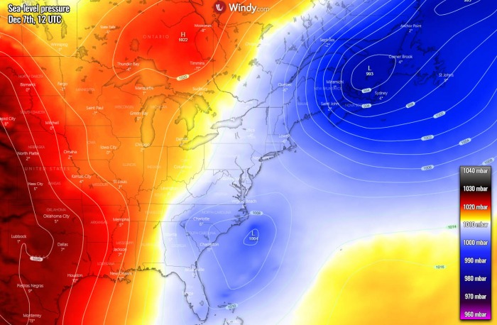
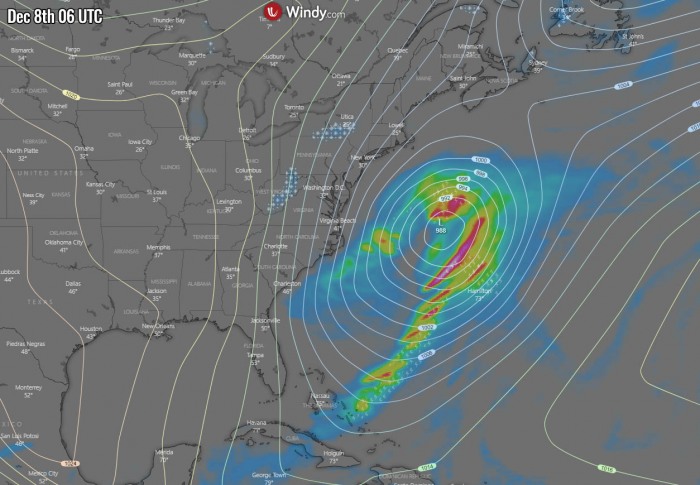
As both troughs emerge into the Southeast United States, surface pressure begins lowering over the mid-Atlantic coast and Florida. Its core will be to the east of the coast and organizing.
Meanwhile the low over Nova Scotia and Newfoundland are pretty well visible, finally ejecting east into the northwest Atlantic through Monday.
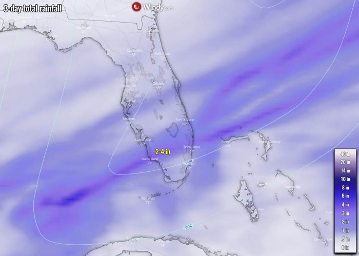
A cold front associated with the surface low will move across southern Florida, some storms are expected but with only marginal severe weather threat due to a lack of instability in the area.
But it will bring some rain for the southern half of Florida and the Florida Keys, also across the northern Bahamas. Heavy rain and storms will continue further into the Atlantic Ocean, following the progress of the low.
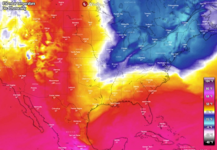
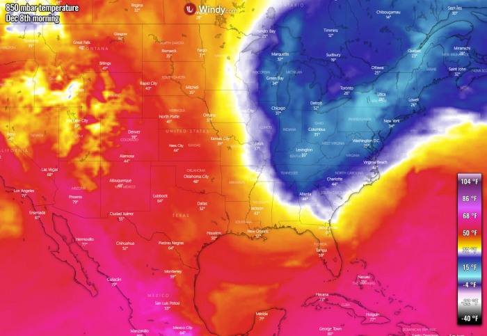
The pool of cold air mass will remain across the northeast United States, but will soon begin spreading south as the surface low develops along the Southeast Coast. It will be quite cold Monday over the Great Lakes and the East Coast. Notice, warm weather is well spread across the western CONUS.
While the warmth to the west will persist, a cold air mass will push far south across the Eastern United States.
Tuesday, Dec 8th
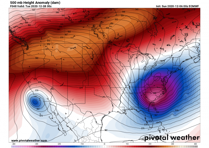
Now this 500 mbar heights chart on Tuesday reveals, that the merging troughs over the Southeast United States have strengthened into a pretty deep trough/low. Its core will be pretty low and cold weather will push into the low-levels.
The locked-in pattern is well-visible, with strong ridging fully developed over northwestern CONUS and southern Canada.
The deep trough results in a strongly organized associated surface low, and the system actually enters a bombogenesis* phase. This means that the pressure will begin rapidly deepening while the system moves further northeast.
The trough will move over the Gulf Stream, a strong ocean current that brings warm water from the Gulf of Mexico into the Atlantic Ocean.
Therefore, their strong temperature contrast will boost the cyclone’s intensity.
*Bombogenesis – is a popular term that describes a mid-latitude cyclone that rapidly intensifies, dropping its central pressure for at least 24 mbar over 24 hours. This can happen when a cold air mass collides with a warm air mass, such as air over warm ocean waters. The formation of this rapidly strengthening weather system is a process called bombogenesis, which creates what is known as a bomb cyclone.
A strengthening of the low will also result in a much more organized frontal system. Storms are expected along the front and the rains will be quite heavy but the activity will be away from the land, over the open waters of the Atlantic.
With the deepening of the trough and the bombogenesis taking place on Tuesday, a quite significant cold advection pushes the cold towards the Southeast. Very cold weather moves into the Great Lakes.
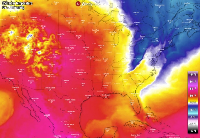
Warmth remains on the West, with well-above normal temperatures across many states for early December.
Wednesday, Dec 9th
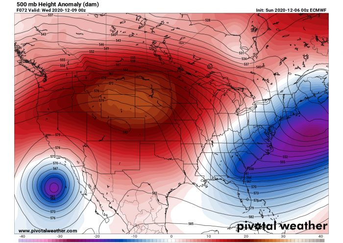
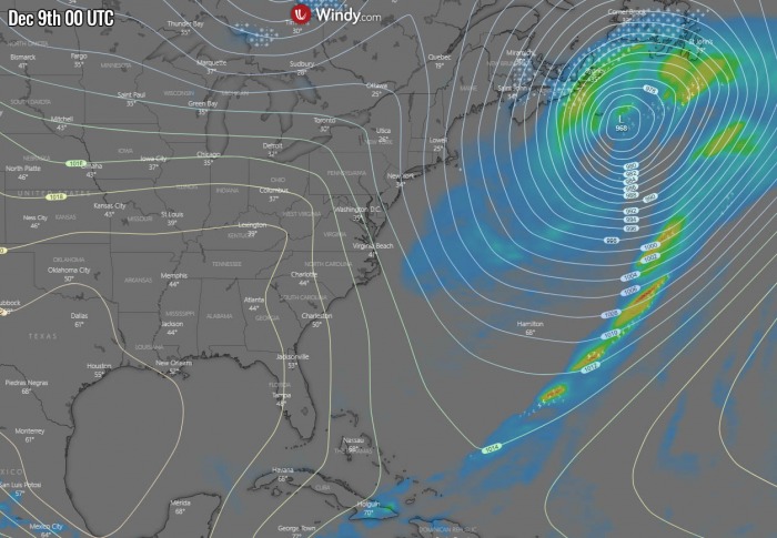
The extensive blocking over the western United States and Canada expands further east and south, so the deep trough begins accelerating towards the northeast on Wednesday. It is ejecting off the East Coast towards Nova Scotia and Newfoundland.
Notice there is also a small but intense cold-core to the west of the Baja California peninsula. So the pattern actually transforms into an Omega blocking pattern through late this week.
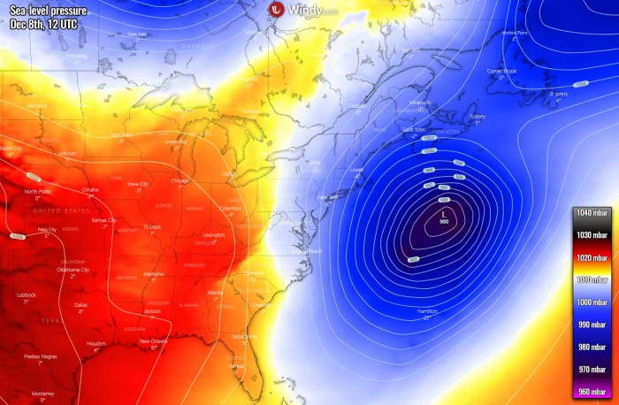
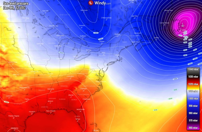
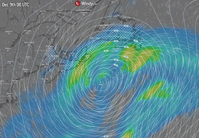
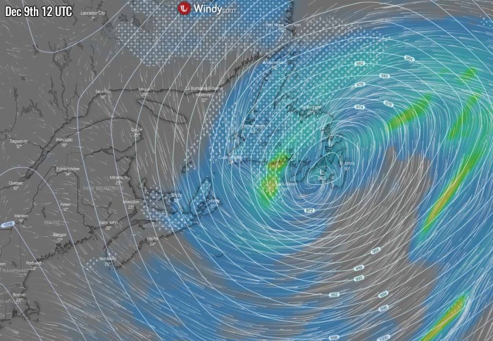
The surface low, now acting as a bomb cyclone, will continue moving northeast towards Nova Scotia and Newfoundland on Wednesday. It will be very deep at this time, likely close to around 960 mbar in the morning hours. The pattern will then change in its wake, as higher pressure will expand into the Southeast United States.
The frontal system will be approaching Nova Scotia through Tuesday night and heavy snow with blizzard conditions will develop. The southern portions of Newfoundland will get rain first, but winter weather is forecast further inland.
We can see that the temperatures on Wednesday will be recovering and warming up, the warmth to the West is quite impressive. The cold pool, associated with the outbreak into the East Coast and the Southeast United States, will gradually weaken and eject towards the northeast as the bomb cyclone is moving away.
The pattern will establish much warmer temperatures through the mid-week and towards the weekend again.
FROST ACROSS THE SOUTHEAST UNITED STATES
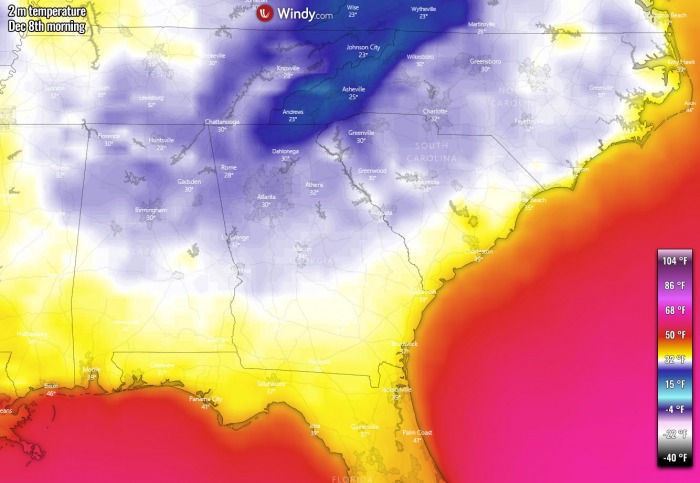
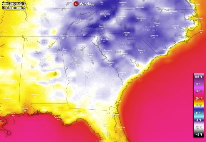
The cold air mass spreading south behind the deepening trough/low will also increase chances for morning frosts across the Southeast United States. It seems like that winds could limit some significant cooling on Tuesday, but Wednesday could bring even lower morning temperatures and front also down to northern Florida.
It will be below freezing on Wednesday morning, 25-30 °F across Georgia and South Carolina. The high-pressure system will expand and winds will be very low.
INTENSE SNOWSTORM FOR NOVA SCOTIA AND NEWFOUNDLAND
As discussed earlier, the deep low will be acting as a bomb cyclone on Tuesday and Wednesday, when it spreads towards Nova Scotia and Newfoundland.
By Tuesday evening, the low will have the closest pass by Nova Scotia, so heavy snowfall and blizzard conditions are likely. As well as further northeast where winter weather conditions will be worsening along the warm front as well.
The frontal system will be accelerating when moving across Newfoundland through Wednesday morning. Heavy snow will be ongoing. The low will likely be near 960 mbar, so the pressure gradient will be quite strong around its center. Blizzard conditions with low visibility are expected.
Depending on where exactly the low will pass, some rain will also occur to the southern, warmer side of the system.
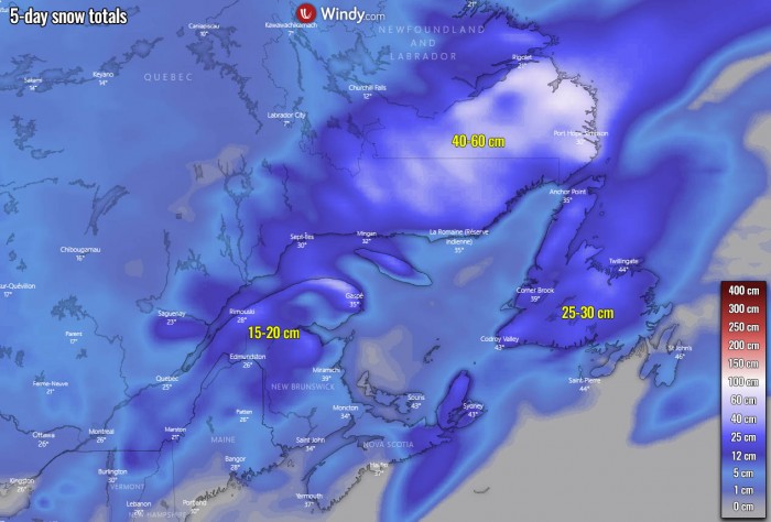
Heavy snowfall will result in quite high accumulations of fresh snow across far eastern Canada, also across part of Nova Scotia and Newfoundland. 20-30 cm seems likely to accumulate with the snowstorm on Wednesday. Pushed in drifts due to potentially severe winds coming up with the deep bomb cyclone.
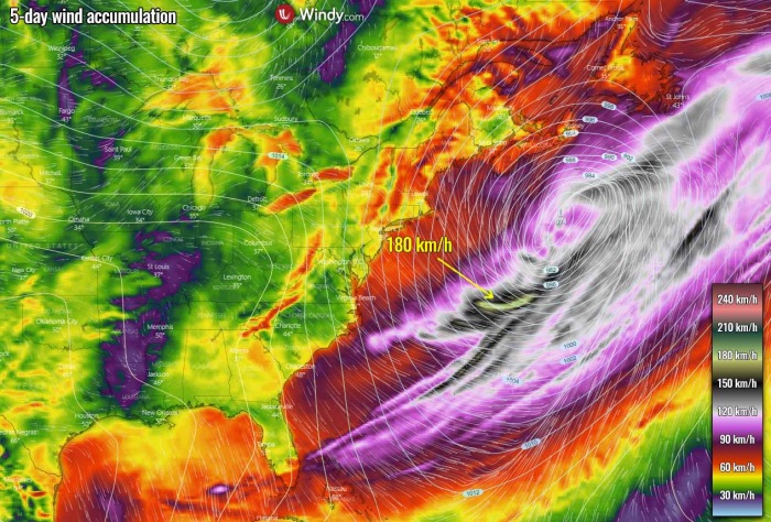
During the rapid intensification of the low, violent hurricane-force winds will develop over the Atlantic.
Weather models hint that close to 180 km/h (110 mph) gusts will result during the peak of the bombogenesis process on Tuesday. Those will gradually decay while spreading across a broad area on Wednesday, reaching Newfoundland as well. But will mostly remain to the south of the peninsula with their maximum height.
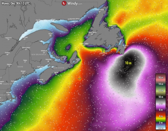
Strong winds will also generate significant wave heights, potentially up to 10 meters near and south of the cyclone’s core. Some of those waves will also affect the southern portions of Newfoundland.
Don’t miss a chance for a nice gift for your friends, family or someone special… Weather calendar could be the perfect gift for them – see below:
