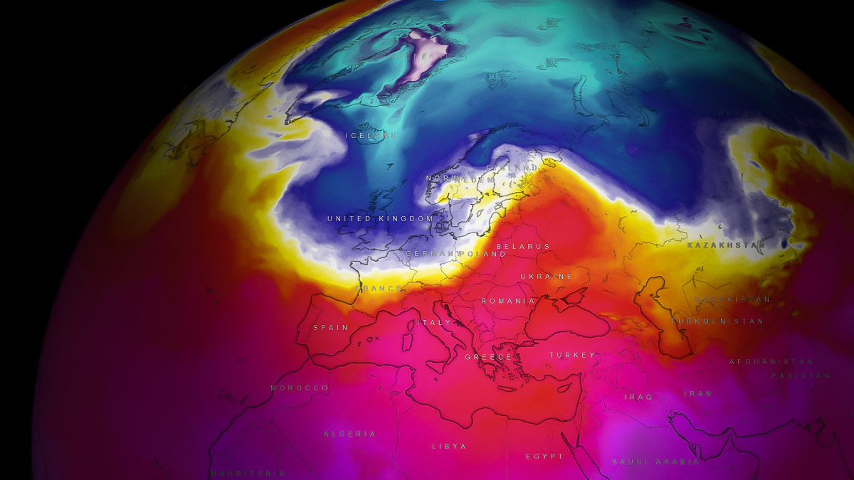
A significant change is finally shaping up in Europe in the following days. The weather pattern forecast over the continent indicates a deep low will form in the north, releasing the first Arctic cold blast into the western and central parts of the continent over the weekend into early next week.
After a historic heatwave and unprecedented warmth from September into mid-October, the weather pattern is about to flip this weekend. A temperature change is forecast to be quite sharp along the moving cold front, spread across a large part of the continent by early next week. Lowlands across western and central Europe can expect the season’s first frosts.
A frontal system starting the mid-autumn cold outbreak in Europe will also dump quite some fresh snow over parts of Scandinavia. Wintry showers are also forecast for the northern UK and possibly northern Denmark.
Many parts of Europe again shattered some high-temperature records this Wednesday, with 29-32 °C across south-central France, and 25-29 °C was reported from Germany. Southeast England also peaked into the low 20s again, after multiple days around 25 °C.

Temperatures will be a few degrees lower until the weekend when an Arctic blast enters from the northwest.
Attached below is the Meteogram chart for London, England. It represents the 850 mbar (approximately 1250m above sea level) temperature and the precipitation over the following 14 days.
We notice some precipitation is forecast from Thursday through Saturday, with temperatures around 5-7 °C above normal.

Then, a sharp temperature decline is forecast for Friday night as the Arctic front crosses. On Sunday morning, temperatures at this level will be around -5 °C, which is about 10 °C colder than normal for mid-October. Therefore, the temperature drops by around 16-18 °C in about two days.
Let’s dig into details on the pattern development as we head towards the weekend.
A Dramatic Weather Pattern Flip over Europe, Arctic Cold Blast Enters Western Europe over the Weekend
We can agree warm weather is nice in the autumn season, but some refreshment was really missing in these past few weeks. Week after week, strong heat domes developed into the European continent and released record-breaking heatwaves. Finally, this is about to change.
An extensive blocking High dominating Europe through the first two weeks of October will soon be replaced by a powerful Arctic intrusion of cold air mass from the north. As the High collapses on Friday, a deep Low will dig south over the weekend.

In its wake, a widespread cold blast will be transported from the Arctic region, bringing temperatures around 10 °C below normal for Western Europe. If we remember how much warmer than normal it was in the recent weeks, this will be a pretty significant change.
The cold front will cross Ireland and the UK on Friday afternoon, emerging into continental Europe early Saturday and extending from the Baltic region to central France. Then, continue east-southeast progress into Sunday, reaching the Balkan peninsula Sunday night.
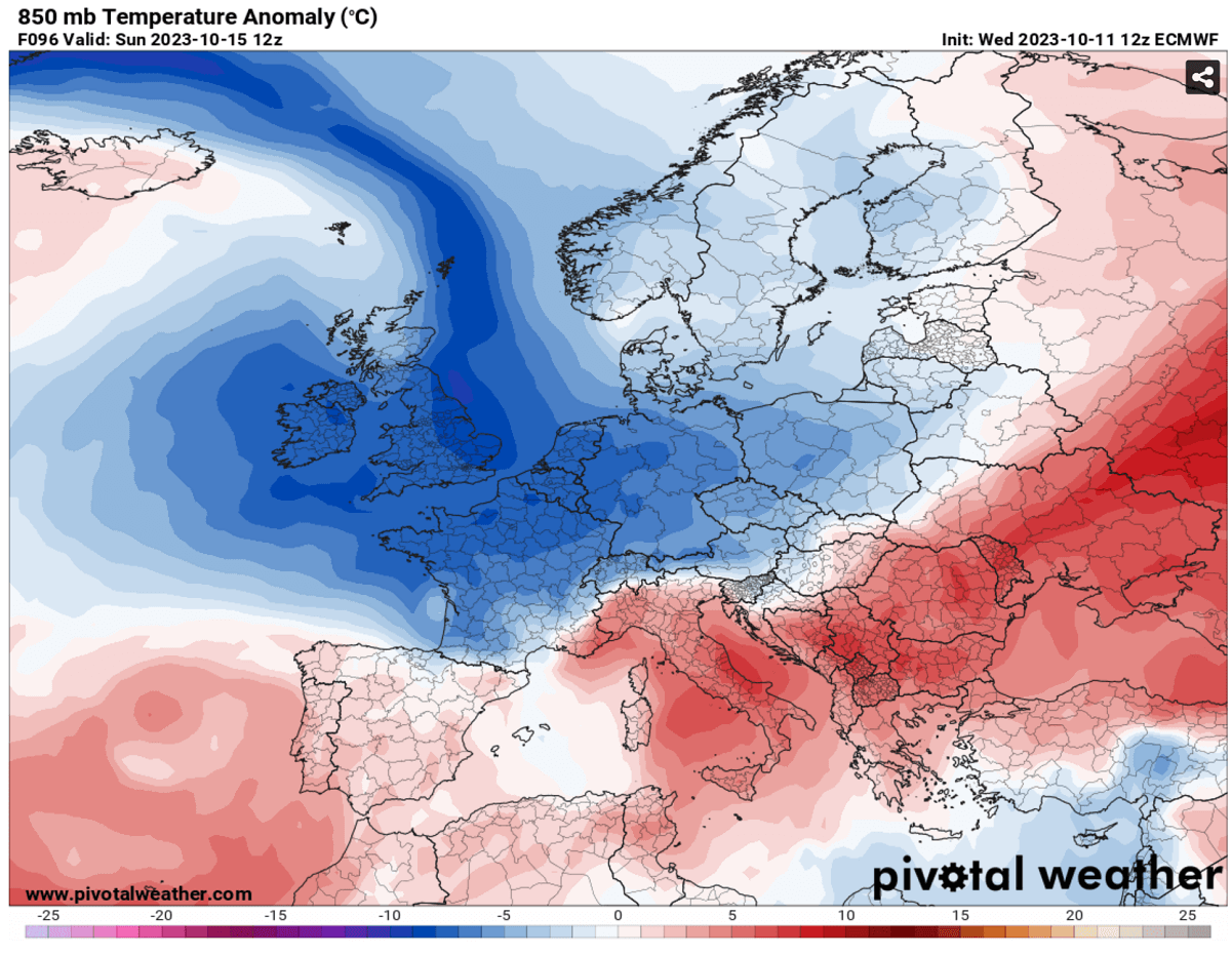
Thursday, Friday, and Saturday will remain unusually warm for Italy and the Balkans before the front emerges from the north. On Monday, the cold front and an intrusion of significantly colder air mass will continue towards southeastern Europe. Also reaching the northern Mediterranean.
The video animation below indicates how sharp temperature change will develop along the cold front. It starts Saturday in the west and quite rapidly spreads into central Europe.
Then, the cold pool continues towards the northern Mediterranean and across the Balkan peninsula on Sunday.
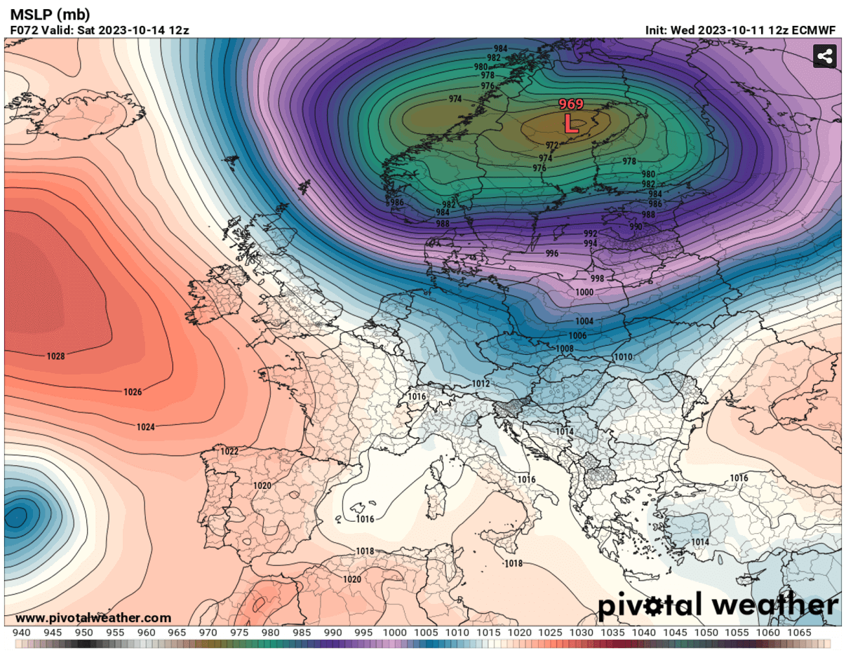
A Deep Low Develops over Northern Europe, bringing a Lot of Snow to Scandinavia. Wintry Weather for Northern UK
As discussed, the upper-level low will be pretty deep, resulting in a significant pressure drop into northern Europe. A deep surface low, possibly below 970 mbar, is forecast to develop over Scandinavia. It will also enhance the frontal system and release a much colder air mass towards the continent.
A frontal system will bring heavy snowfall across western-southwestern Norway, northern Sweden, and Finland. With fresh snow accumulations up to 30-50 cm across large areas.
The highest snow is forecast for the mountains of southwestern Norway, with local snowfall accumulation approaching 100 cm until Tuesday next week.
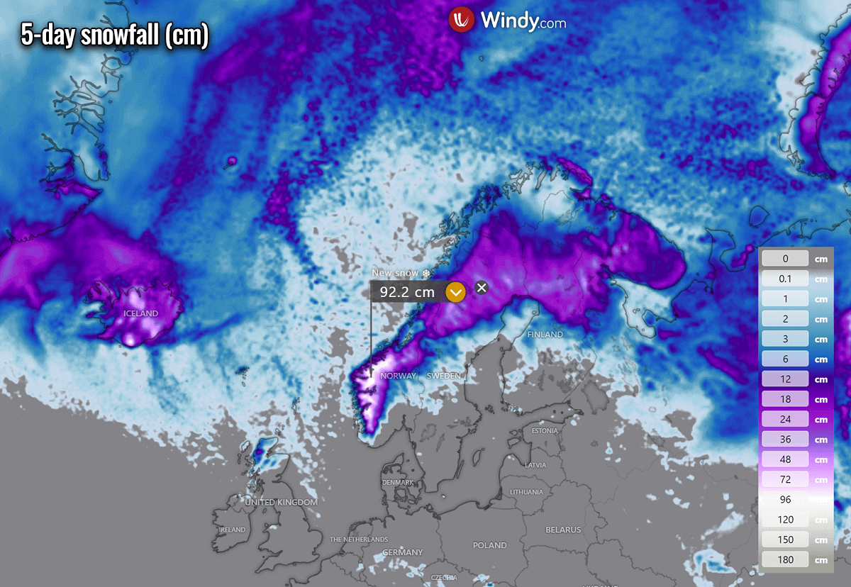
Wintry showers with snow are also possible over the northern UK and Northern Ireland on Saturday and Sunday. Northern Scotland’s higher elevations should get some accumulated snow.
Around 10-15 cm of fresh snow is forecast for the Scottish Highlands by Sunday evening. Elsewhere, accumulating snow is unlikely due to warm soil from the recent warm waves, despite snow showers forecast to occur.

Some high-resolution models also hint at some chances of snow showers over Denmark and north-central Germany on Sunday, but snow on the ground is not expected.
Arctic Blast brings the First Frost of the Autumn Season 2023
A significantly colder air mass than we were experiencing recently will spread behind the sharp cold front on Saturday and Sunday. With about 4-7 °C below normal across Ireland and the UK, sharpening overnight to Sunday and the next days.
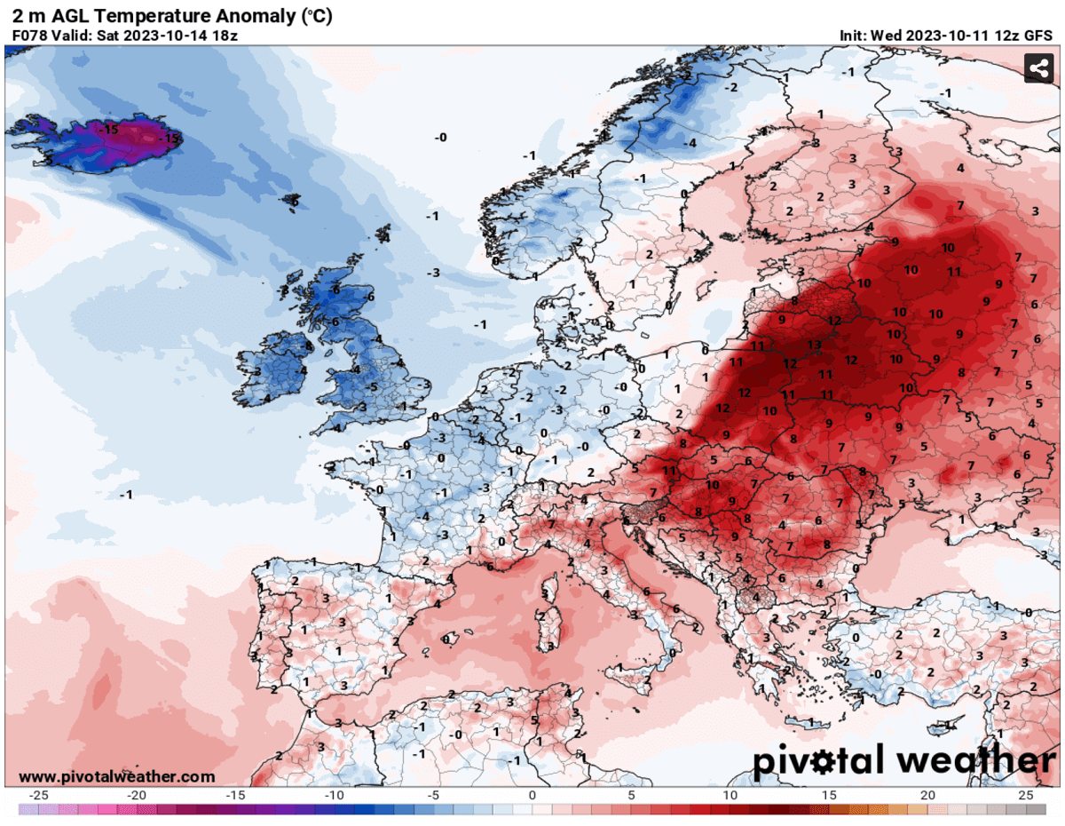
Ahead of the cold front, a sharp temperature contrast can be seen on the chart above. Significantly anomalous temperatures will remain across central Europe on Saturday, especially across eastern Europe, with daytime high temperatures above 25 °C locally again.
The first affected will be western Europe on Saturday, as the cold front crosses Ireland and the UK on Friday night. The temperatures will likely be the lowest on Sunday morning with clearer weather.
Near or below-freezing temperatures are forecast for Ireland, Northern Ireland, northern England, and Wales, and a few degrees below 0 °C over Scotland.

Chilly northwesterly winds will keep temperatures pretty cool on Saturday and Sunday afternoons. Peak daytime temperatures should remain below 10 °C, around freezing over the Scottish Highlands.
The sharp surface cold front enters Benelux and Germany from the northwest on Saturday early morning, so the day before, Friday afternoon, will be another warm day with peak temperatures into the mid-20s. Even higher temperatures over southern France will remain.

Much colder weather is forecast on Saturday and Sunday, with daytime temperatures remaining in the low 10s. Once the winds calm down late Sunday, Monday morning is forecast to be frosty from eastern France and southern Belgium across central and southern Germany to the western Czech Republic (right chart above).
A few degrees below freezing is forecast. Even lower temperatures are forecast for the Alpine valleys in northern Austria.
Wetterzentrale, Wxcharts, Windy, Meteociel, PivotalWeather provided images used in this article.
See also: