UPDATE August 20th, 2026: Fall 2026 Forecast Update: Super El Niño Builds a Split-Flow Pattern Ahead of Winter 2026/2027
A powerful Super El Niño is now emerging as the main global weather driver for the Fall and Winter seasons ahead. Also, the latest ocean analysis confirms that warm anomalies are building at a remarkable pace, setting the stage for a highly active weather pattern as we head into the upcoming cold season.
This is important because Fall is usually a transition season, with weaker and less organized seasonal patterns. But the newest forecast trends suggest a more connected evolution, where the Super El Niño influence just keeps amplifying.
In this article, we will quickly look at the latest ocean data, then the first Fall 2026 long-range forecast, and the North American pressure pattern that will get amplified towards mid-Winter. The main signal is not just that Super El Niño is growing, but that its atmospheric impact may already be building early, with important consequences for the 2026/2027 Winter season.
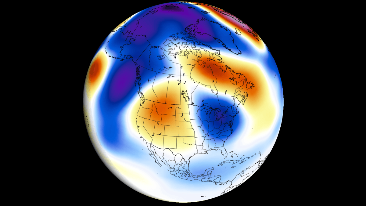
Planetary Dynamics: The Oceanic Impact on the Atmosphere
All latest forecasts show that ENSO will be a major global weather driver in 2026/2027. This is short for “El Niño Southern Oscillation” and refers to a region of the equatorial Pacific Ocean that alternates between warm and cold phases every few years on average.
In this cycle, we are entering a strong El Niño warm phase. Below, you can see the usual changes it makes to the upward and downward atmospheric motion in the tropical regions, called a Walker Cell, which is especially sensitive to strong ENSO events. It also shows the change in atmospheric motion during a moderate versus a strong El Niño event, impacting the global weather system.
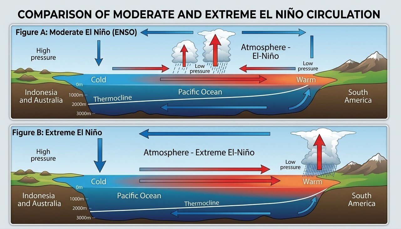
Usually, a strong El Niño causes a pressure drop in the central and eastern tropical Pacific and a high-pressure zone over the western Pacific. This has a major influence on the tropical rainfall and pressure patterns, filtering into the mid latitudes and the global weather system.
We are currently observing a very strong El Niño event developing, forecast to peak as one of the strongest such events in decades.
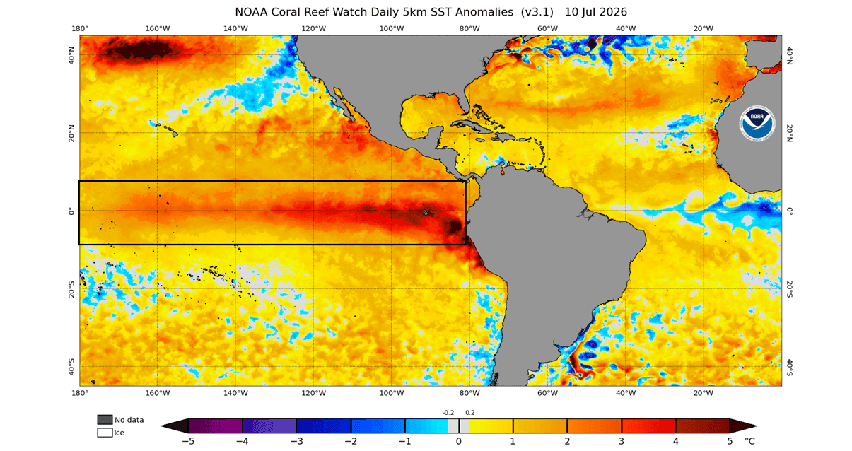
The latest ocean analysis below shows the main ENSO region already covered in emerging strong warm anomalies. You can see the peak anomalies in the eastern parts reaching already 3-4 degrees above normal, which is a very rapid onset of strong anomalies at this time of the year.
Below is the latest 90-day ocean temperature anomaly across the main ENSO region. You can see a significant warming trend across the region, showing strong growth of the El Niño event. Also note that this is the new relative ENSO index, which is usually lower, so the raw anomaly is already over +2 degrees.
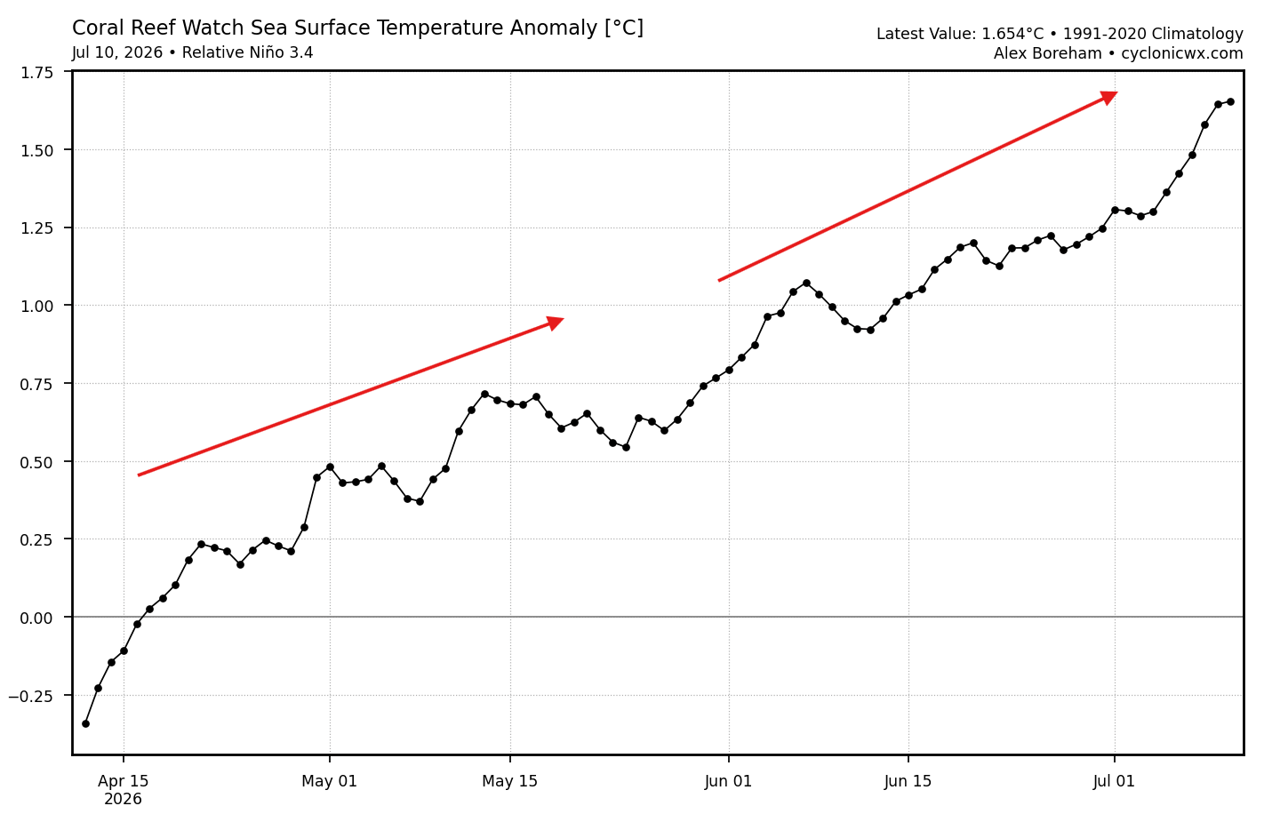
This confirms a very strong event emerging, with immediate impact on weather development first in North America and the tropics, spreading rapidly worldwide. To be classified as a Super El Niño event, the sustained seasonal values must be above +2 degrees, which will be easy achievable by this event.
We have also produced a video from the latest ocean data, which you can see below. The video shows changing ocean anomalies over the past weeks. You can see the strong emergence of the El Niño, with peak values now in the eastern regions exceeding +3-4 degrees above normal.
And as you will see, the latest forecasts show that this El Niño does not plan to stop growing any time soon, aiming to become a Super El Niño event.
2026/2027 Super El Niño for the History Books
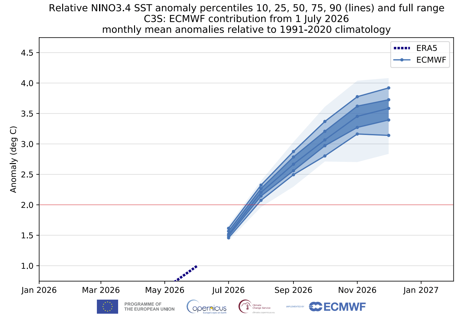
Looking ahead, you can see the ensemble forecasts below for the main ENSO region. The average forecast from all the calculations is strongly above the +2 threshold for a Super El Niño. It shows a seasonal peak above +3 degrees, making this the strongest known El Niño event on record, if verified.
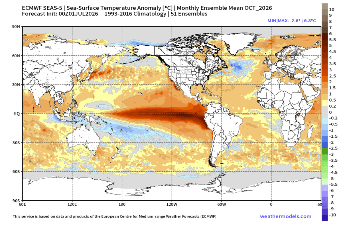
El Niño events tend to reach peak anomaly later in the year, during late Fall or early Winter. The latest forecasts reveal a significant ocean temperature anomaly through October 2026 already. You can see this in the forecast below, with anomalies peaking over +6 degrees. Anomalies of this magnitude could merit this as a historically strong El Niño event.
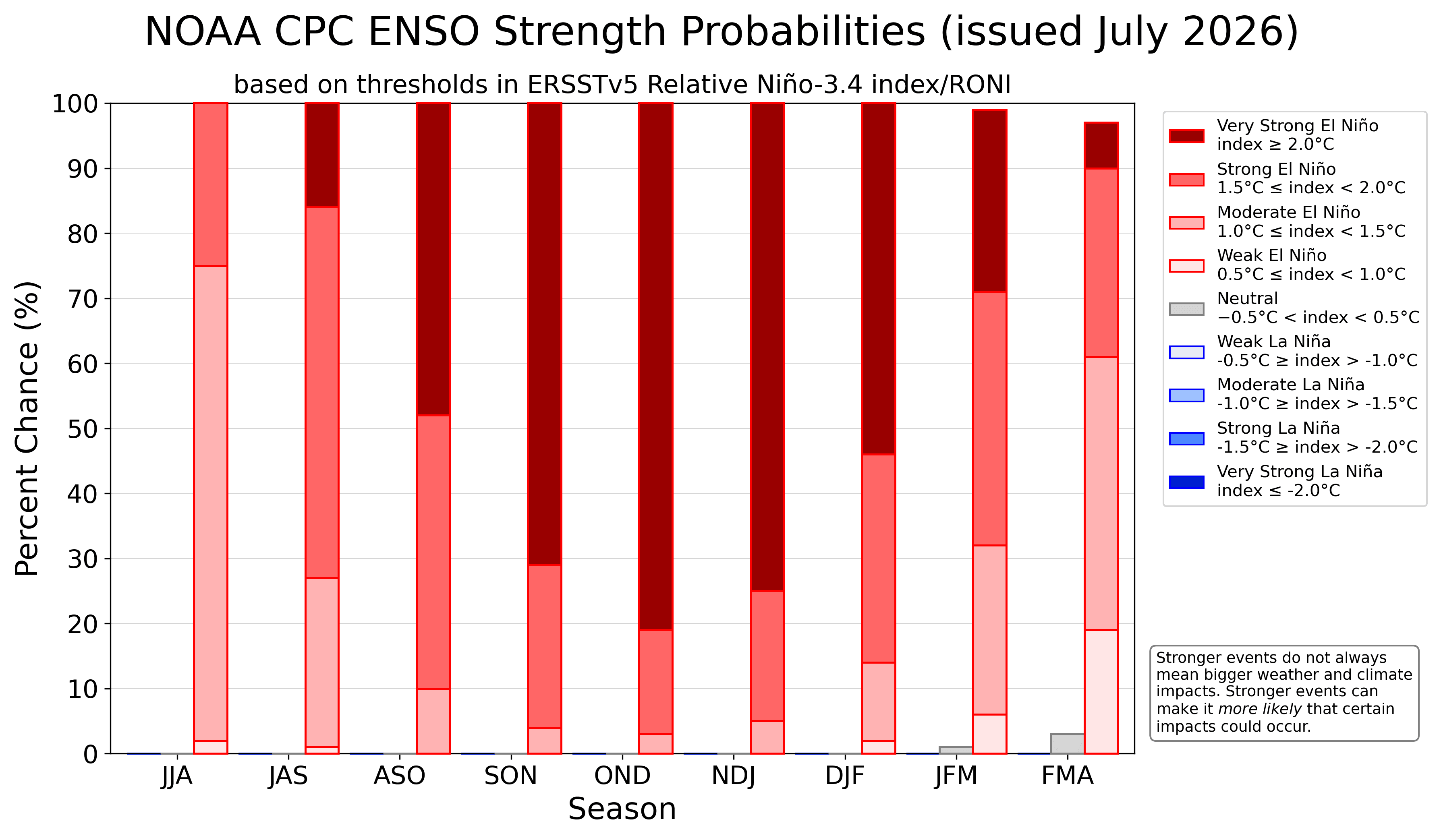
Below is the NOAA CPC strength probability, which also shows the likelihood of a very strong El Niño event, peaking in late Fall and early Winter. You can see an overwhelming support for this event to end in the extreme El Niño category, based on the latest evolution and predictions.
It is not easy to find anything close in the past data, to search for potential atmospheric impact on the Fall season. But we can at least look at the last two super El Niño events to see what we can expect in Fall.
Past Super El Niños reveal the Fall signal to watch
We produced two special graphics that show temperature and precipitation patterns for the Fall season in the last two Super El Niño events. We only chose the last 2 events as they are still in a more “recent” climate, while events over 4 decades ago were in a different global state.
The temperature analysis shows above-normal temperatures over the northern and central parts of the United States, south-central and western Canada, and western parts of Europe. This comes from the El Niño high-pressure system, which usually develops in Fall over Canada.
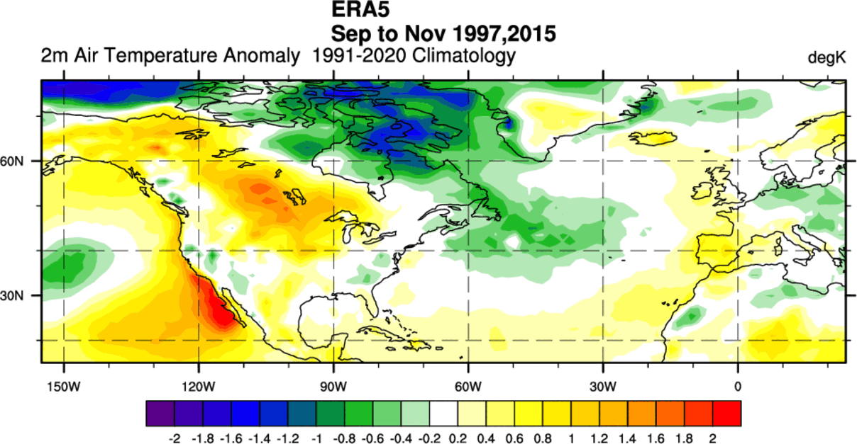
Normal to below-normal temperatures were detected across the U.S. West Coast, the Southeast, and over northern Canada and central Europe. This comes from the subtropical jet stream, starting to get amplified in an El Niño.
Precipitation patterns in a Super El Niño follow the amplified subtropical jet stream, which usually starts in Fall. That means more rainfall over the central and southern United States, extending into the Atlantic and bringing more rain also to southern Europe. More rainfall is also over the West Coast of the United States.
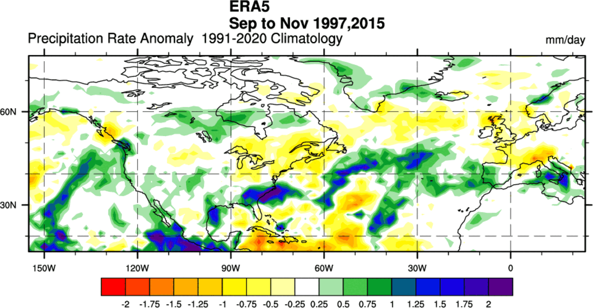
Below normal rainfall can be expected over the northern and northeastern United States, and over west-central and northwestern Europe.
But these are the weather patterns from only two actual seasons. It’s time we look at what the actual fresh long-range forecast shows for the upcoming Fall of 2026.
The First Fall Forecast Already Looks Unusually Evolved
For the first Fall 2026 forecast, we decided to focus on the two main (or most used) seasonal models: The ECMWF model and the North America NMME, which is a combined forecast from several different seasonal models from the United States and Canada.
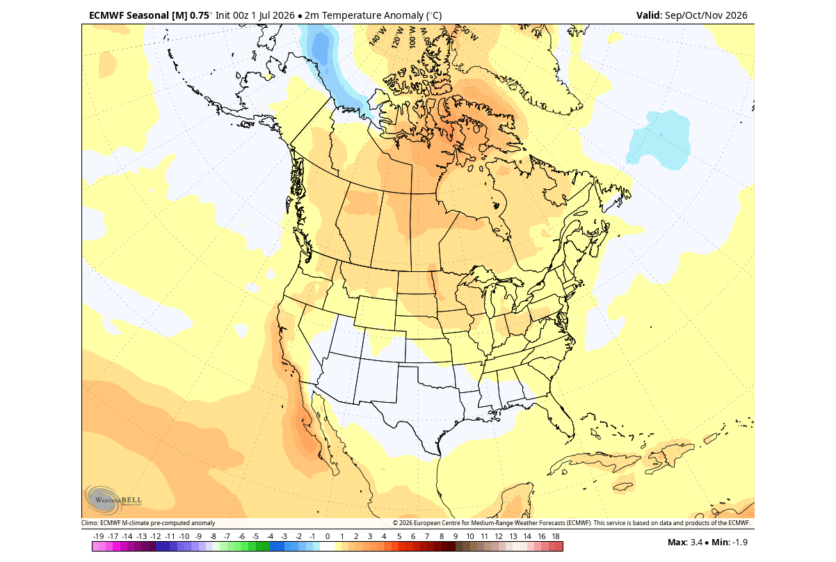
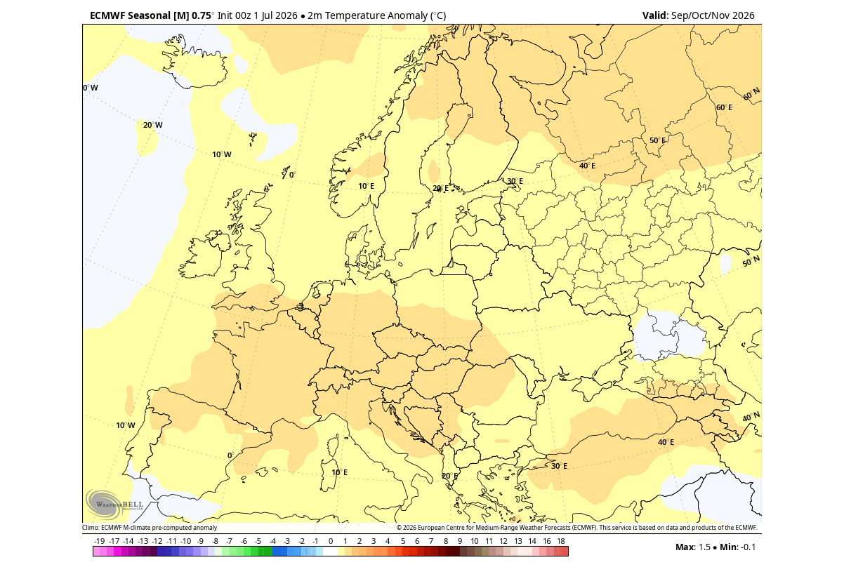
All these forecasts are an average picture over 3 months (September-October-November) and show the general prevailing weather pattern forecast for the meteorological Fall.
The pressure pattern forecast shows an unusually evolved pattern, more similar to the typical El Niño Winter response. It is likely ahead of time in Fall already, due to the strength of this El Niño event. We have a high-pressure anomaly over Canada, with the El Niño Pacific low, and a chain of low-pressure systems (storms) over the southern United States.
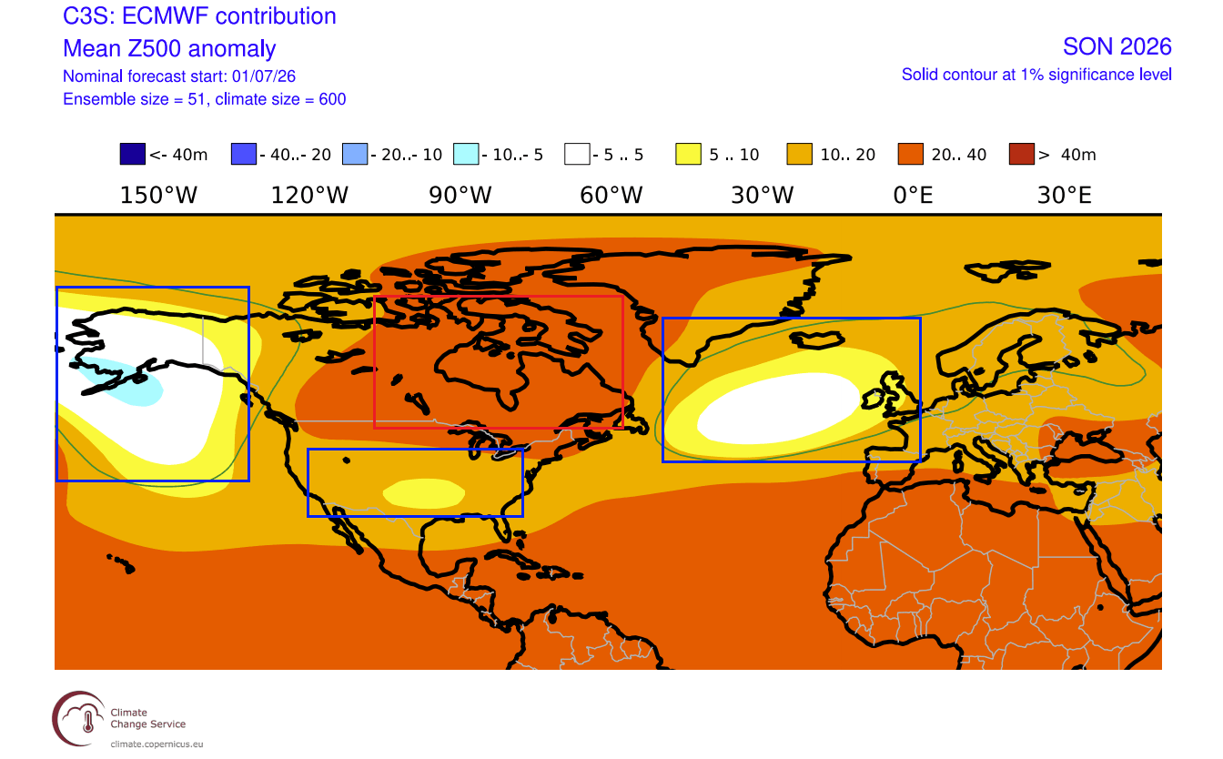
Further east, a low-pressure area is indicated over the Atlantic, reaching into the UK and Ireland. This promotes a westerly flow over the continent and a warmer southerly airmass rising towards the north.
As mentioned, this is actually a really impressive pattern, because it more resembles the typical El Niño Winter pressure anomaly, as seen in the image below. You can see a low-pressure area in the North Pacific, a high-pressure zone over Canada, and a low-pressure storm track across the southern United States, just as the Fall forecast above.
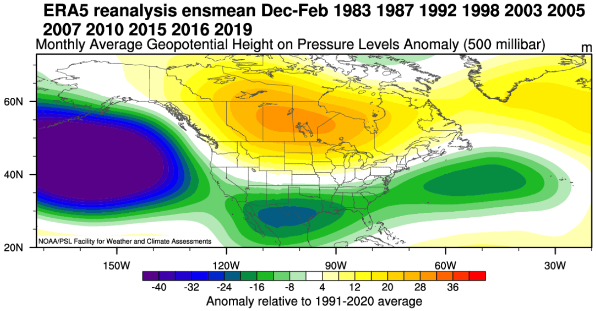
This is an interesting development, and really shows how strong the global forcing is from the potentially historical El Niño event.
The surface pressure anomaly also shows an interesting pattern over the tropics. A broad low-pressure zone is forecast to cover the eastern tropical Pacific, indicating a full atmospheric El Niño presence, with high-pressure in the rest of the belt. This is a clear confirmation of the El Niño influence on the tropical and global circulation in the forecast data.
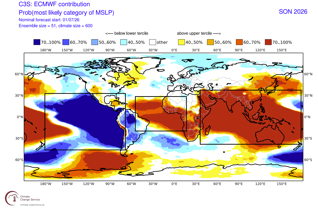
Such a pattern is also a great demonstration of the Walker cell, with lower pressure on one side of the globe indicating rising air, and sinking air causing higher pressure on the other side of the Planet.
This is the most clear “hello world” signal of the Super El Niño, now starting to embed its influence into the seasonal temperature and precipitation patterns.
Temperature and Rainfall Begin to Follow the Larger Pattern
Starting with North America, we see the core of warmer temperatures under the high-pressure area over the northern half of the United States and over Canada. Due to a more persistent low-pressure storm track starting to establish in the southern half of the United States, we expect the temperatures to remain around normal.
Over Europe, we can see warmer-than-normal surface temperatures over much of the continent. Warmer anomalies are focused on the central, western, and southeastern regions, driven by the westerly and southwesterly flow, with a warmer airmass.
Looking at precipitation, you can see a very evolved El Niño signature, with increased rainfall over most of the United States, especially in the south, due to the amplified Pacific jet stream. An amplified Pacific jet brings more moisture and low-pressure systems, creating more precipitation and unsettled weather.
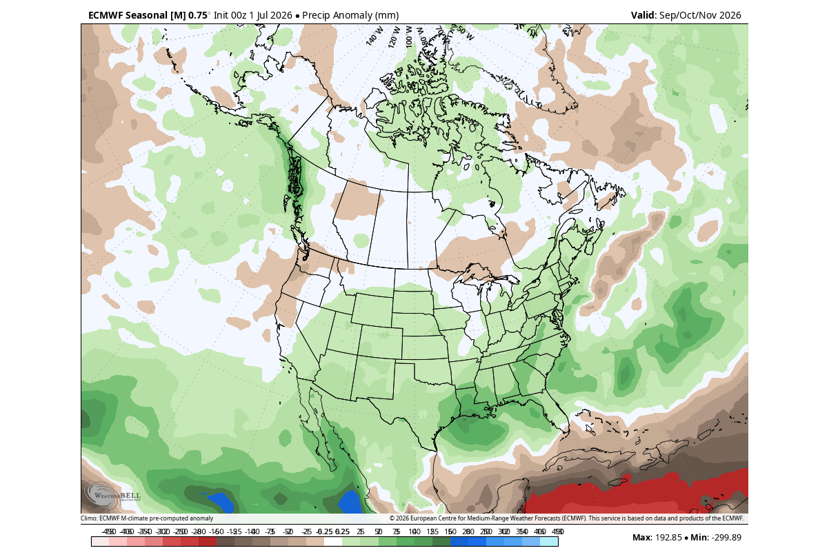
We can see areas with below-normal rainfall in the northwestern United States, the upper Midwest, and over southern, western, and northeastern Canada.
For Europe, the forecast shows above-normal Autumn rainfall across much of the continent. This is the result of a more westerly flow from the Atlantic low-pressure area, bringing in a lot of moisture and increasing precipitation potential.
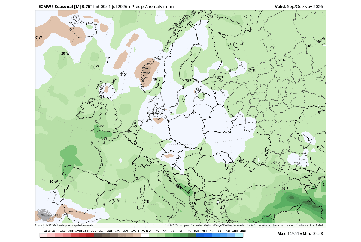
Overall, this shows a rather surprising pattern, because it indicates a very evolved state of the atmospheric El Niño impact, more typical to see for early-mid Winter.
A North American Model Shows the Same Pattern Dominating
Besides ECMWF, we often use the NMME forecasting system. It stands for North American Multi-Model Ensemble (NMME). It combines several individual models from the United States and Canada to show an average forecast picture, merged from different solutions.
Looking at the NMME ENSO forecast, you can see it also shows a very strong El Niño developing and peaking in the late Fall-early Winter period. This configuration can explain why we are seeing winter-like pressure and weather patterns already developing in the Fall.
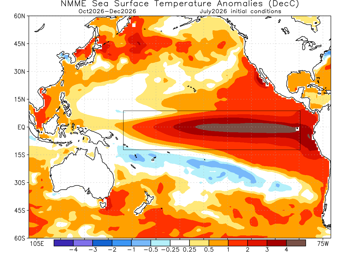
For this reason, we decided to also quickly look at the NMME model, to verify if it also shows the rapid evolution of the atmospheric El Niño impact. This is especially visible over North America, which is under the direct ENSO impacts.
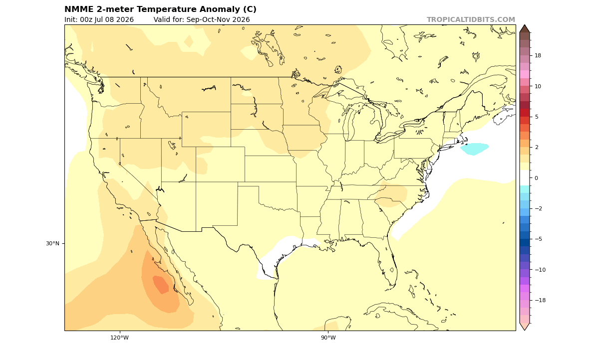
Looking at North America, it shows a similar forecast to ECMWF, with the main warm anomaly focused over the northern United States and in the western half of Canada. We can see the warm anomaly reducing towards the southern U.S., indicating the expected low-pressure system track and a stronger Pacific jet stream.
The precipitation forecast for North America also confirms the presence of a stronger southern jet stream, bringing moisture and rainfall. As in the ECMWF forecast, the bulk of the above-normal rainfall is over the southern and southeastern U.S. in this model too, with more rainfall also across the central and eastern United States.
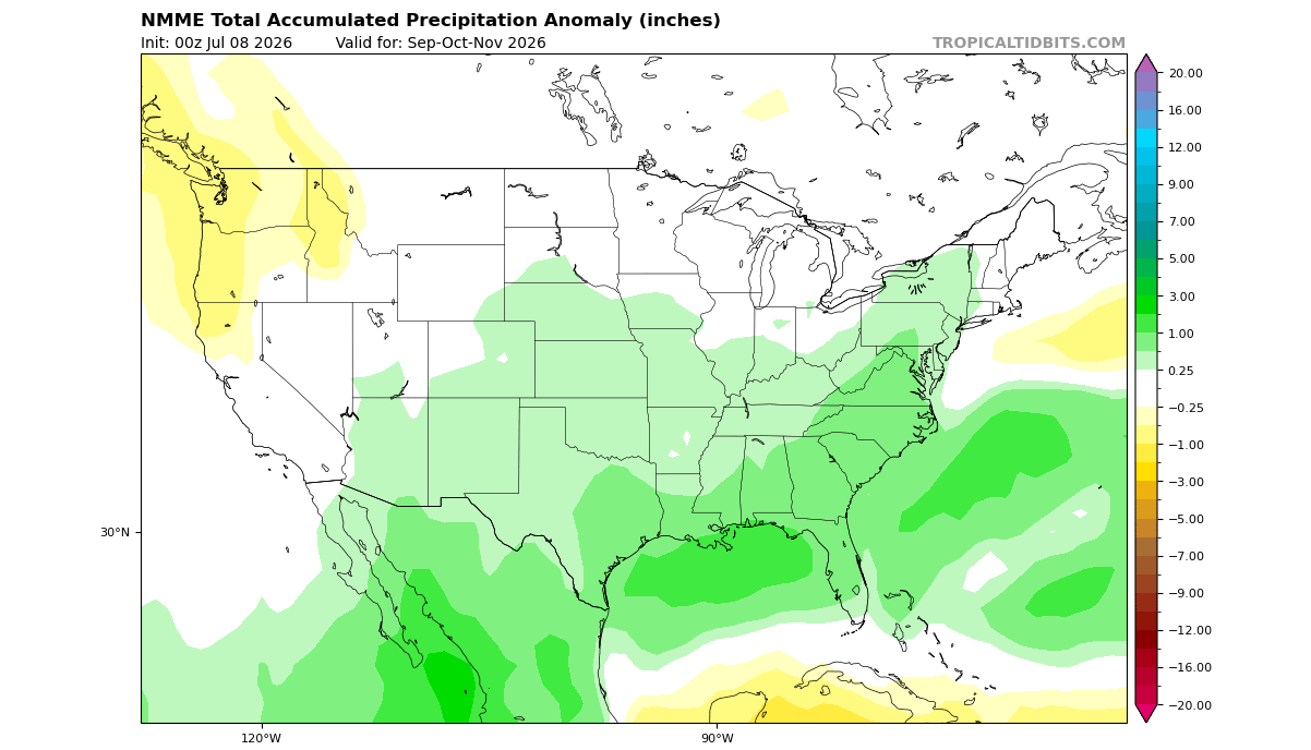
Less rainfall than normal is seen over the Pacific Northwest and parts of southern Canada, due to the high-pressure area building over Canada in this pattern
The surface temperature forecast for Europe shows a slight temperature contrast, with the warm anomaly increasing from west to east. This indicates a more westerly flow, the same as in the previous model above.
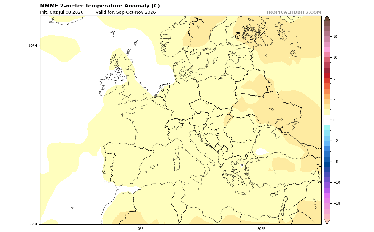
This can be confirmed by looking at the precipitation forecast for Fall, as we see wetter conditions across the northwestern, central, and southeastern parts. This suggests a likely low-pressure system in the North Atlantic bringing in mild and moist oceanic air, very similar to the ECMWF forecast.
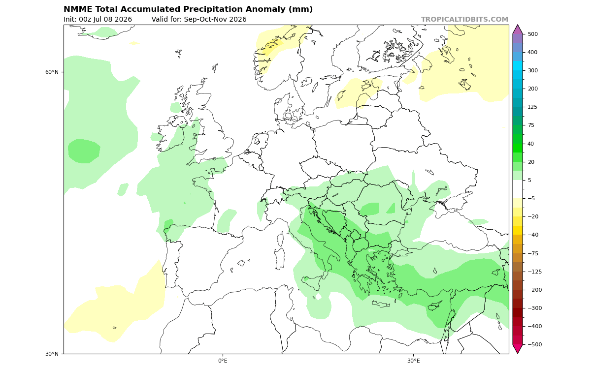
This further confirms (along with ECMWF), that we can expect an amplified pattern evolution from this powerful El Niño event. And the latest forecast data shows just this, creating a full Fall-Winter amplification of the weather patterns.
El Niño Forcing: A Winter-like Pressure Pattern Coming in Fall
For this reason, we decided to also look at the pressure pattern for November, which is the last month of the meteorological Fall, and compare it with mid-Winter (January). This directly reveals just how much stronger the Winter pattern gets under proper conditions.
The image below shows the direct comparison between the November, December, and January forecasts (from left to right). You can see a significant change in the strength of the anomalies in the otherwise static pressure pattern. We can see a signature strong El Niño winter signal, but surprisingly, it is already developed in mid-late Fall.
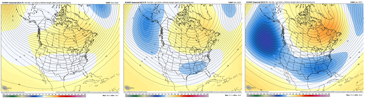
While it is normal for pressure systems getting stronger into Winter, creating deeper anomalies, we are looking at a single static pattern amplifying over time. This gives a strong signal of just how locked in the super El Niño impact really is.
Looking closer at the January forecast trend, we see a high-amplitude Winter pattern dominated by a high-pressure blocking anomaly over Canada in the mid-levels. This strong atmospheric ridge acts like a large boulder in a river, deflecting the polar jet stream and creating a milder, warmer-than-average Winter across most of Canada and the far northern United States.
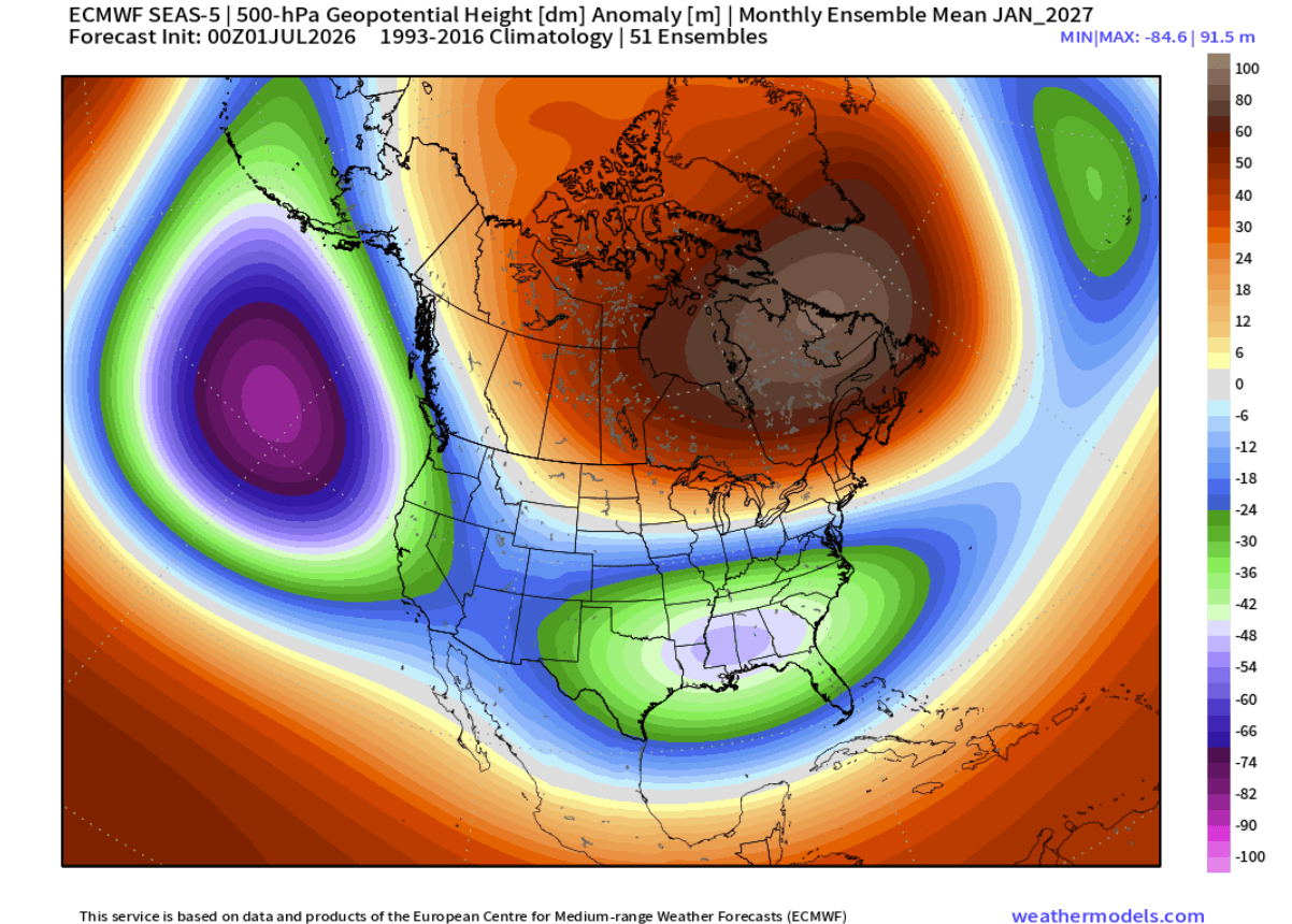
In contrast, a highly active low-pressure zone is forecast to stretch straight across the southern and eastern United States. This represents a supercharged subtropical jet stream, which brings frequent, moisture-rich systems to the Southern, Central, and Eastern United States.
The ECM ensemble mean also shows a highly amplified sea-level pressure pattern over North America, with strong positive anomalies centered over Canada and Greenland, and broad lower pressure anomalies extending from the North Pacific into the western, southern, and eastern United States. This is a classic high-amplitude setup, with blocking/ridging to the north and an active low-pressure corridor underneath it.
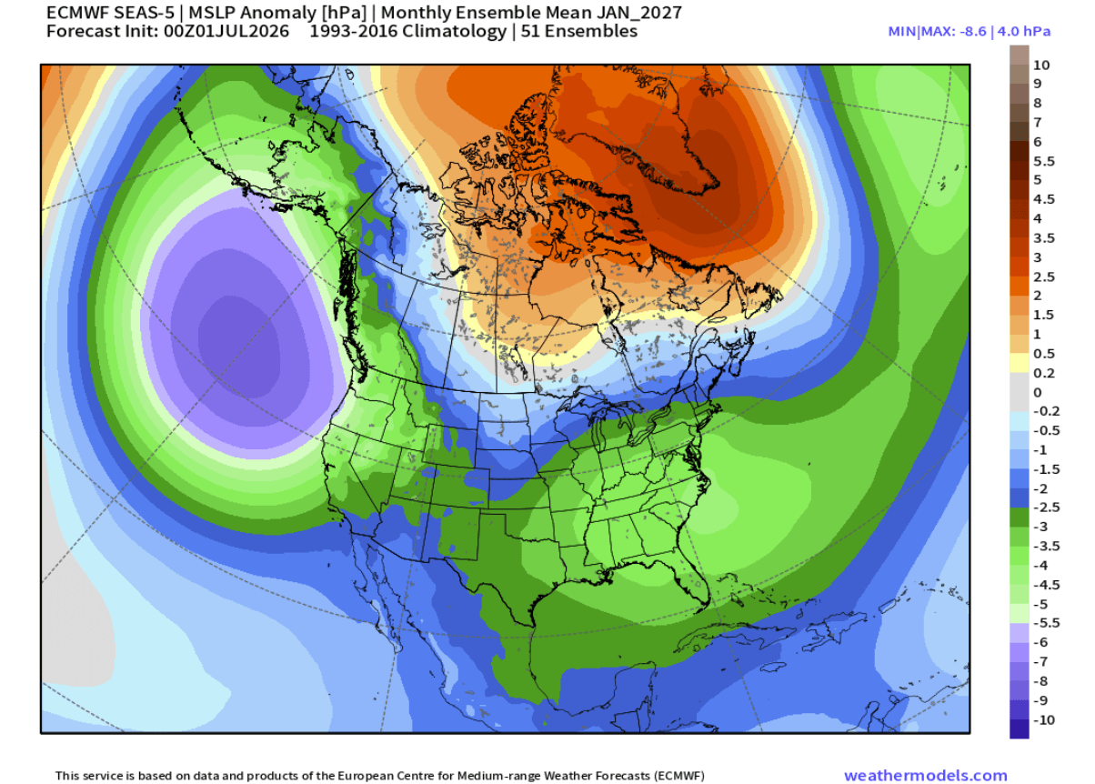
Such a pattern supports a stronger southern storm track across the United States, while the Canadian high-pressure anomaly can help deflect colder air southward into parts of the central and eastern United States. It does not guarantee individual snowstorms or cold outbreaks, but it signals a winter pattern with increased potential for stronger storm systems and sharper temperature contrasts into January.
Below is the November-January temperature forecast comparison, which shows the usual El Niño signature in late Fall (left): warm Canada and northern U.S., and normal to cooler temperatures towards the central and southern parts of the United States. But in January (right), the intense blocking forces a clear corridor of normal to below-normal temperatures into the U.S.
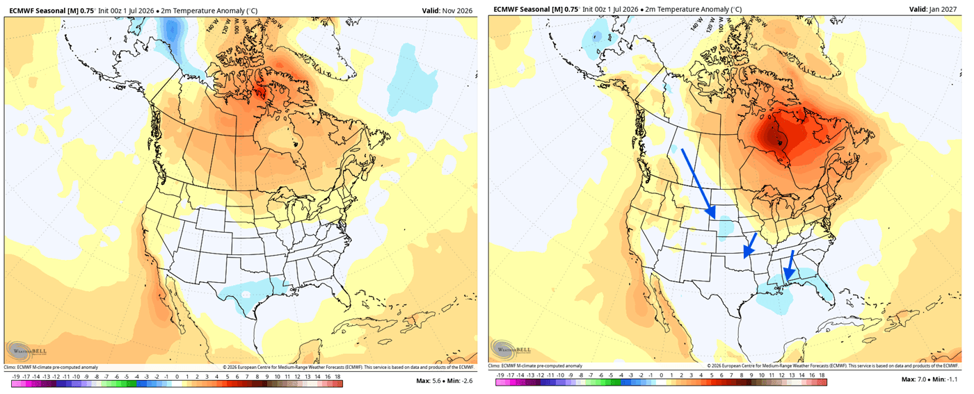
As the cold air pathway locks into the central and eastern United States by January, it can provide the missing temperature ingredient to mix with an active southern storm track. Together, they can significantly raise the potential for strong winter storms and severe cold outbreaks as the season reaches its peak.
We can also see a stable pattern evolution over Europe, from Late fall to mid-Winter. Since Europe is not under a direct El Niño impact like North America, we do not see such amplified anomalies as above in the mid-levels. But we can see a very stable pattern, with a low-pressure zone over the northwest, driving a persistent westerly and southwesterly mild flow.
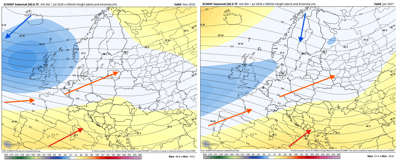
This still tells us a lot about the impact of the El Niño, and how it is creating a very stable grip on the atmosphere during late Summer and into Fall. This only intensifies as we go into the Winter season.
The sea-level pressure anomaly forecast shows a broad low-pressure signal across much of Europe, strongest from western/northwestern Europe into central and northern parts of the continent. At the same time, higher pressure is indicated toward Greenland and the far North Atlantic.
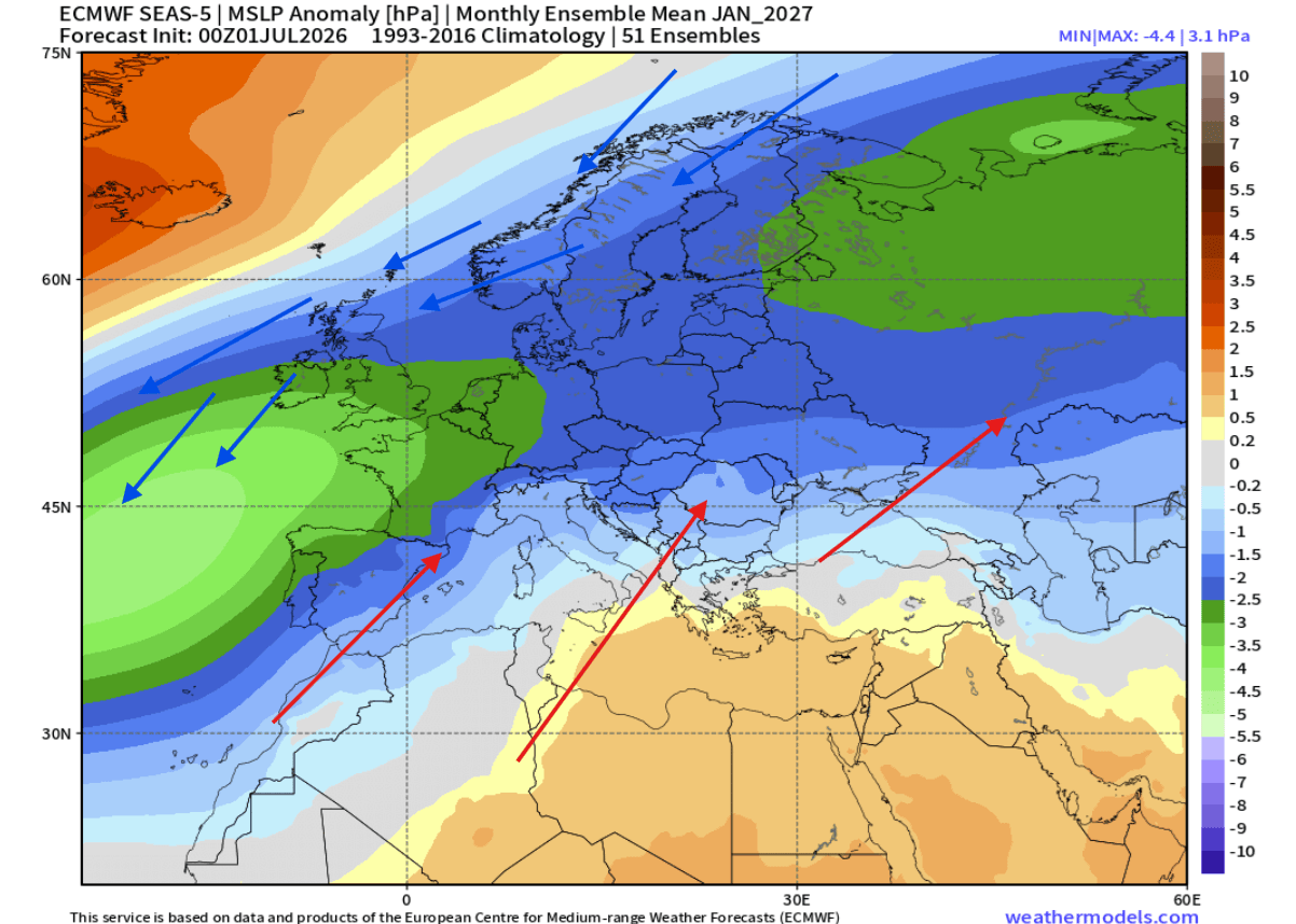
This setup supports a more active west-east storm track, with frequent low-pressure systems, more wind, mild air, and above-normal precipitation potential across mainland Europe. The main cold air corridor is over the northern parts, potentially also favoring the northwestern region for some cold spills.
Below is the seasonal Nov/Dec/Jan temperature anomaly forecast for Europe. We decided to use the seasonal average, since the pattern is very stable. You can see the normal temperatures over the northwestern parts, under the low-pressure zone.
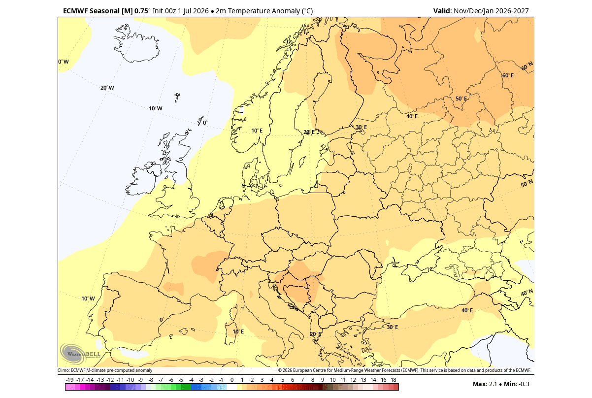
But that low-pressure zone acts as a “pump” that drives mild or warm westerly flow into the continent and further to the east and northeast. This pattern can be really limiting for any proper winter potential, but we are just looking at early trends, so there is plenty of room to improve.
There is one large-scale factor that has a very important role in winter weather and emerges every Fall, impacting the entire cold weather season.
The Polar Vortex Becomes the Next Winter Factor to Watch
The Polar Vortex re-emerges every Fall and plays a key role in seasonal weather development from November to March. So, for this reason, we have to take a quick look at its importance together with a super El Niño.
The Polar Vortex is a large cyclonic area that is spinning over the entire Northern Hemisphere, from the ground up to the top of the stratosphere, reaching over 50km/31miles in altitude.
Below is an image that shows a 3-dimensional model of the Polar Vortex, undergoing a disruption event in January 2026. A high-pressure anomaly in the stratosphere has disrupted its structure. This caused the Polar Vortex to push its lower core into North America, allowing a strong northerly flow with cold air to spill into the eastern United States, Canada, and parts of Europe.
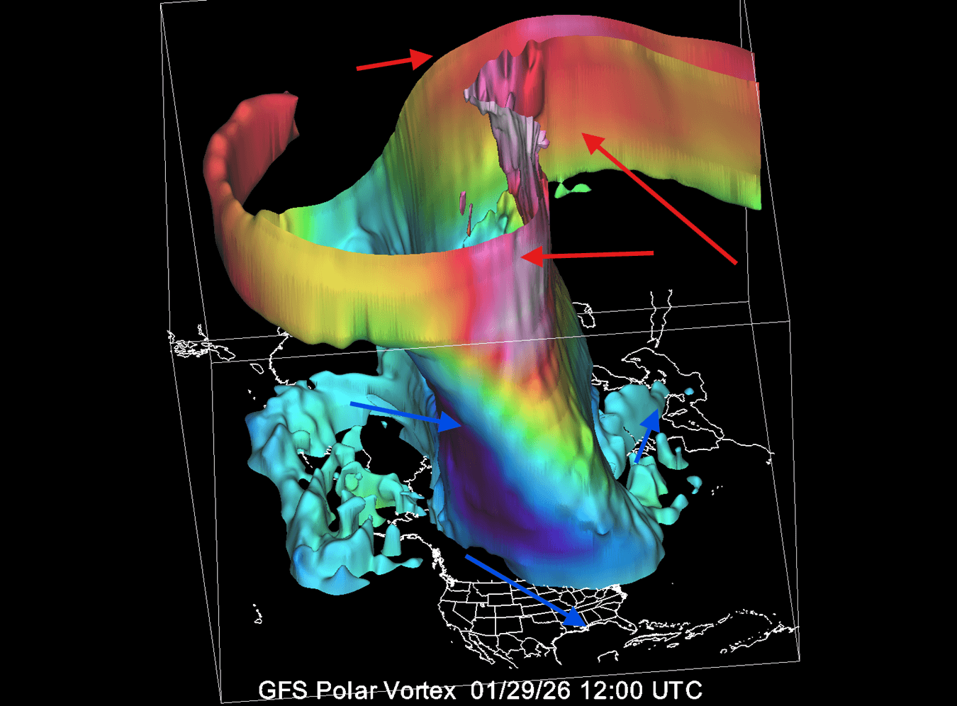
In the example above, the Polar Vortex was undergoing a temporary stratospheric warming event. These events can disrupt the Polar Vortex, weakening its circulation and changing the weather patterns below.
Historically, an El Niño winter has a high chance of producing a Stratospheric Warming Event (SSW). It has produced them in the past and also in the more recent winters. The image below shows the typical SSW event frequency by month and by the ENSO event.
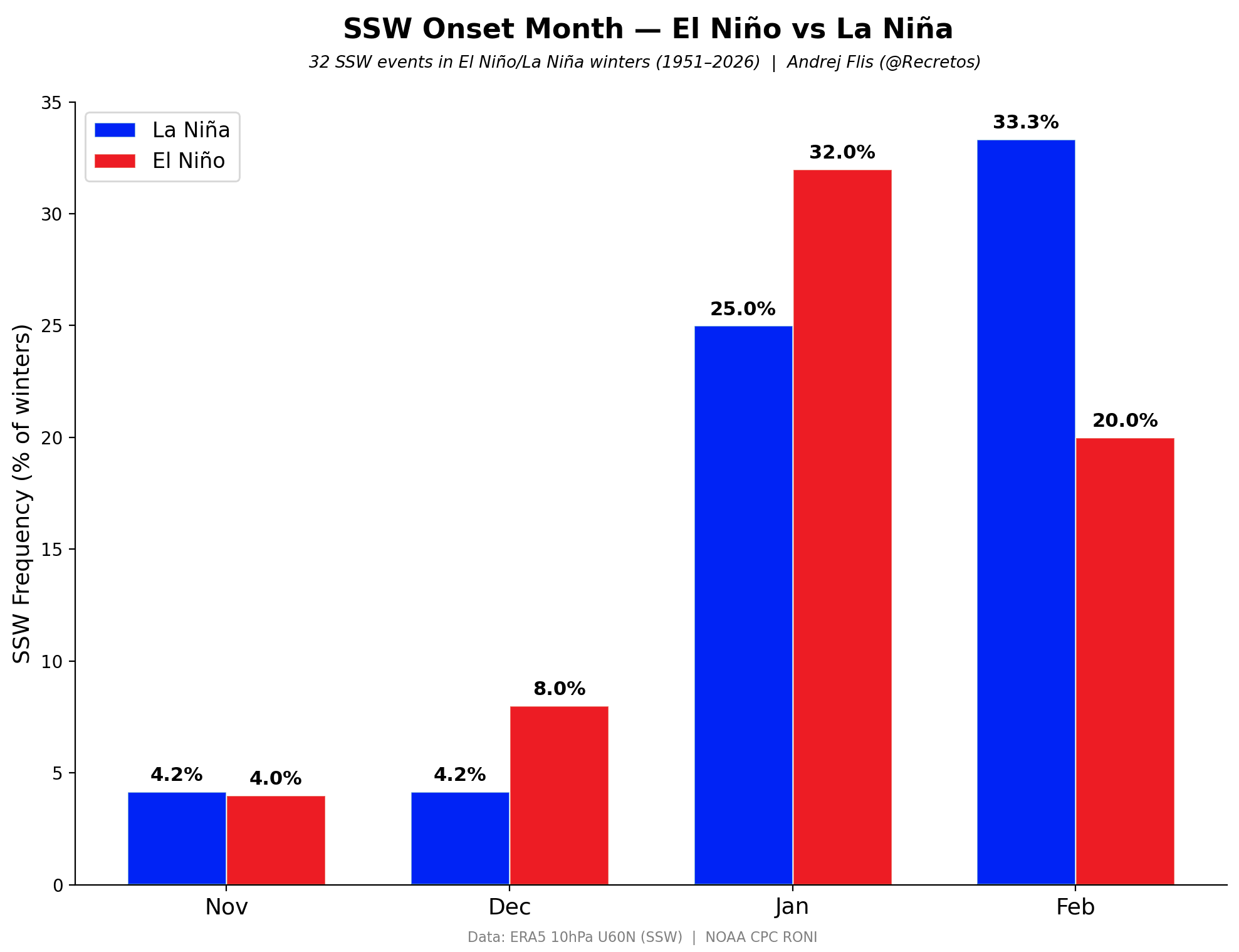
As you can see, an El Niño phase has a higher chance of producing a Polar Vortex collapse event in mid-winter. It also shows a better chance for a Polar Vortex disruption in December and January, compared to a La Niña event, with an especially high impact in January.
A weak Polar Vortex creates a disrupted jet stream pattern, leading to a strong weather response. As a result, it has a harder time containing the cold polar air, which then has an easier path from the polar regions into the United States or other mid-latitude areas.
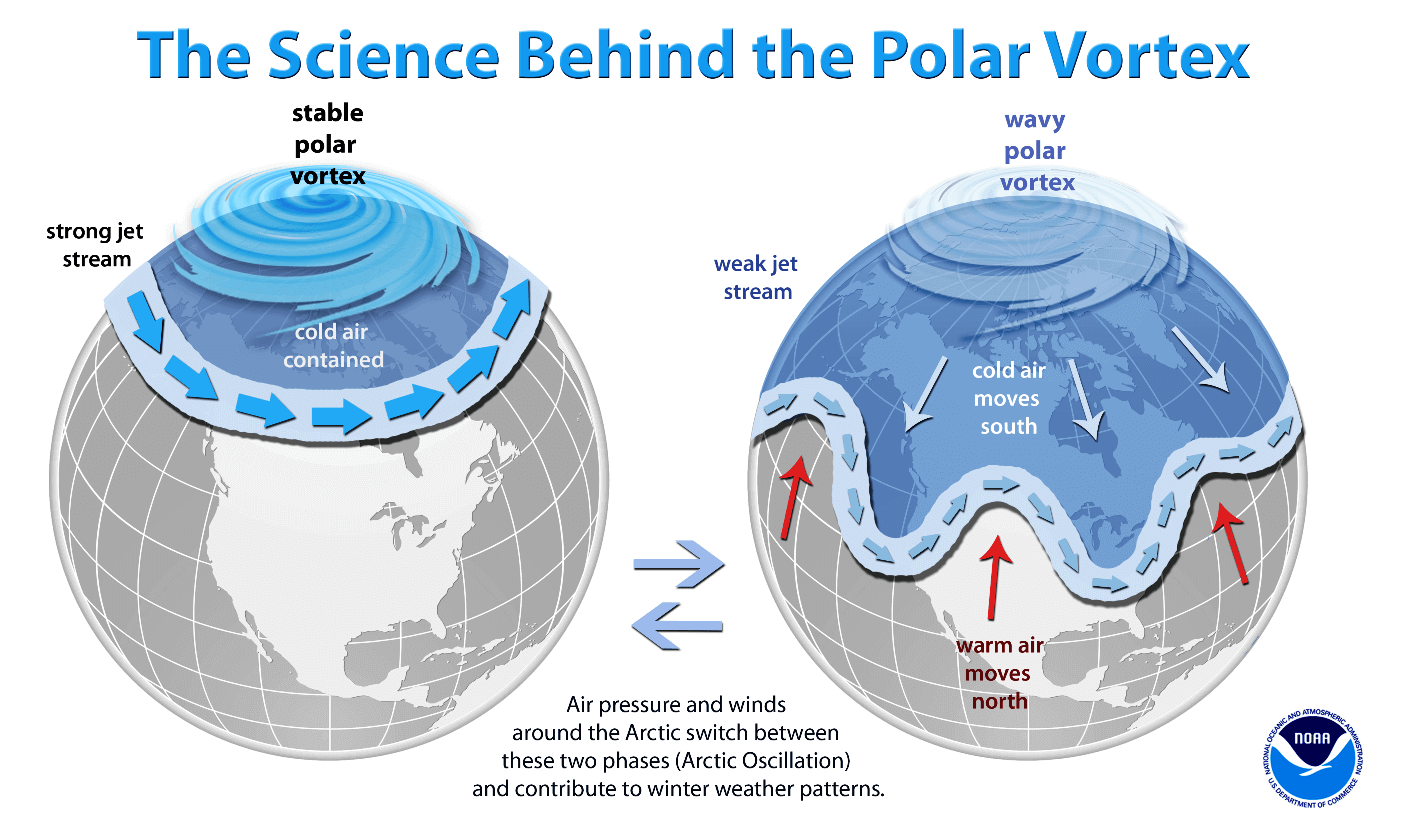
So, if you want a colder and snowier Winter, your best bet is a weak Polar Vortex. In nature, a weak Polar Vortex indicates a full collapse or a major disruption of its structure, resulting in the spill-out of cold air from the polar regions.
While the Polar Vortex plays a much bigger role during the Winter season, it gives us a signal to watch during Fall. These dynamics have a large-scale and long-lasting impact on weather patterns, as a core atmospheric “engine” in the stratosphere.
This is just one of the factors that currently suggests a high potential for weaker winter circulation due to the La Niña. For a more in-depth analysis on the Polar Vortex role in the January 2027 patterns, you can read our latest article: Polar Vortex Warning Signs Emerge for Winter 2026/2027 as Super El Niño Builds
Forecast and analysis images in this article are from ECMWF, TropicalTidbits, weathermodels.com, and WeatherBell (using a commercial license).
We will keep you updated on the global weather pattern development, so bookmark our page. Also, if you have seen this article in the Google App (Discover) feed, click the like (♥) or the star button there to see more of our forecasts and our latest articles on weather and nature in general.