Outlook day 1 (valid: 30/03/2018)
VALID FOR 30-03-2018 SYNOPSIS Europe is dominated by a large upper trough spreading into central Europe with a surface frontal zone moving east through Friday. …
VALID FOR 30-03-2018 SYNOPSIS Europe is dominated by a large upper trough spreading into central Europe with a surface frontal zone moving east through Friday. …
VALID FOR 29-03-2018 SYNOPSIS A large trough over W Europe is advancing towards SE through Thursday with a surface front pushed towards CNTRL Europe. A …
VALID FOR 28-03-2018 A large trough with a deep cyclone moves across W Europe with a secondary low crossing N France and Benelux, while an …
The weather pattern for Europe this week will be dominated by a large trough / cutoff low forming over the Atlantic today and tomorrow and …
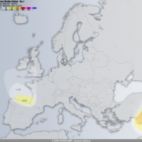
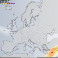
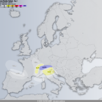
Dust activity that engulfed parts of Greece on Thursday and again today continues tomorrow. We take a look at where Sahran dust will be concentrated …
Large amounts of Saharan dust are suspended in the air all over the eastern and central Mediterranean and Aegean region today. We take a closer …
The coming week looks like it will be a dynamic one. Spring is here. A very dynamic pattern is ahead for the southern half of …
Cyclone Hugo, now in the western Mediterranean is kicking up a major dust storm for the central and eastern Mediterranean and southeastern Europe today and …