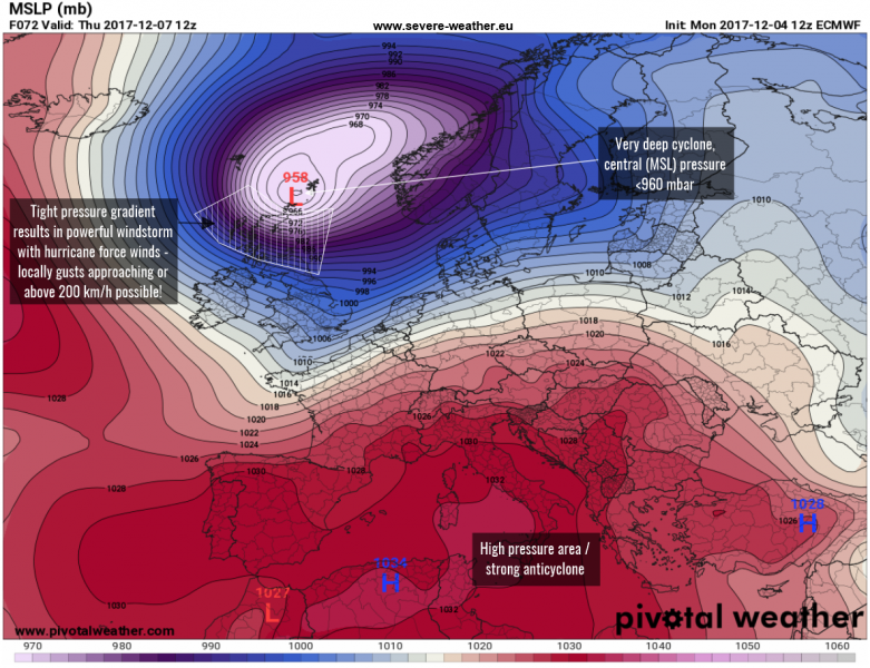
A potentially dangerous setup is forecast for the northern British Isles (mostly Scotland and the surrounding islands) on Thursday. Explosive cyclogenesis (a so-called bombogenesis) is expected to take place north of the Isles in response to a very sharp drop in temperature aloft. As a result, a rapidly deepening cyclone will form from early Thursday morning where central pressure will likely drop from near 985 mb to below 960 mb in less than 12 hours.
Various high-resolutions models (ARPEGE, ICON-EU) are simulating a very dangerous windstorm, where wind gusts could locally reach above 180 km/h or even exceed 200 km/h. Especially severe winds are expected across the higher terrain in the Scottish Highlands. Such intense wind is potentially destructive for property, so be aware of dangerous weather through the whole day.
As the center of the cyclone will be moving north of Scotland, the region will be exposed to dangerous winds for many hours, meaning the hurricane force winds could possibly do widespread damage. Current model guidance indicates the hurricane force winds starting in the early morning hours across NW Scotland and spreading further ESE through the day, gradually weakening in the evening hours. Colder weather should spread behind the system and some fresh snow will also be possible over higher terrain as well.
To repeat: models are currently in generally good agreement for a potentially very dangerous windstorm for Scotland on Thursday – stay alert for life threatening gusts and sea waves along the N-NW coastal areas!
Stay tuned for forther follow-up updates on the evolution of this dangerous windstorm!


