The El Niño effect has long fascinated meteorologists and climate scientists due to its profound influence on global weather patterns. Over the last three decades, this climatic phenomenon has been subject to intense study, revealing its intricate connection to atmospheric conditions. In this article, we delve into the mesmerizing world of El Niño, tracing its impact on climate over the past 30 years. Additionally, we explore how meteorology measures this effect in the atmosphere, shedding light on the methods employed to understand and predict this remarkable weather phenomenon.
Understanding El Niño
El Niño, which translates to “the little boy” or “Christ child” in Spanish, refers to a periodic warming of the equatorial Pacific Ocean, predominantly along the coast of Peru and Ecuador. This warming disrupts the natural oceanic and atmospheric patterns, giving rise to a cascade of effects felt across the globe. El Niño events typically occur every two to seven years, lasting 9 to 12 months.
El Niño profoundly influences climate, triggering a wide array of weather anomalies worldwide. Its effects can be felt on nearly every continent, from severe droughts and scorching heatwaves to devastating floods and disruptive storms. For instance, during El Niño, the Pacific jet stream is often diverted, leading to decreased rainfall in western South America, droughts in Australia, and increased precipitation in parts of the United States.
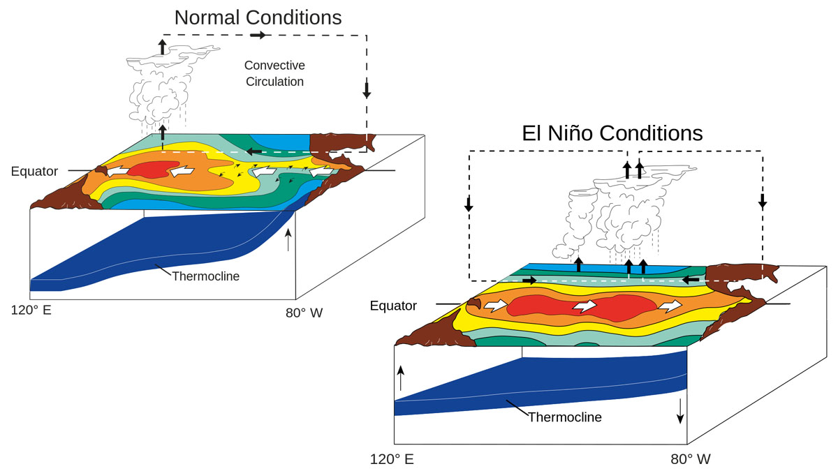
The difference between normal and El Niño conditions showcases the contrasting impacts on global weather patterns and oceanic dynamics.
Measuring El Niño Effect in the Atmosphere
Meteorologists employ various tools and techniques to measure and monitor El Niño in the atmosphere. Satellite-based sensors are also deployed to monitor ocean temperatures and surface winds, aiding in identifying and tracking El Niño events.
The NOAA Jason-3 satellite is a key component of the National Oceanic and Atmospheric Administration’s (NOAA) satellite fleet, designed to monitor and measure ocean surface conditions with exceptional precision. Orbiting the Earth, the satellite collects essential data to enhance our understanding of global oceanography, climate variability, and weather forecasting.
Equipped with advanced instruments and sensors, the NOAA Jason-3 satellite primarily focuses on measuring sea surface height, a critical parameter for monitoring ocean currents, sea level rise, and the El Niño/La Niña phenomena. Using a radar altimeter, the satellite accurately measures the distance between the satellite and the ocean surface, allowing for precise sea surface height measurements.
The data collected by the NOAA Jason-3 satellite plays a pivotal role in various applications. It helps scientists track and study ocean circulation patterns, such as major currents like the Gulf Stream, which impact weather systems and climate dynamics. Furthermore, the satellite’s measurements contribute to assessing sea level rise, providing valuable information for coastal management, climate change research, and developing climate adaptation strategies.
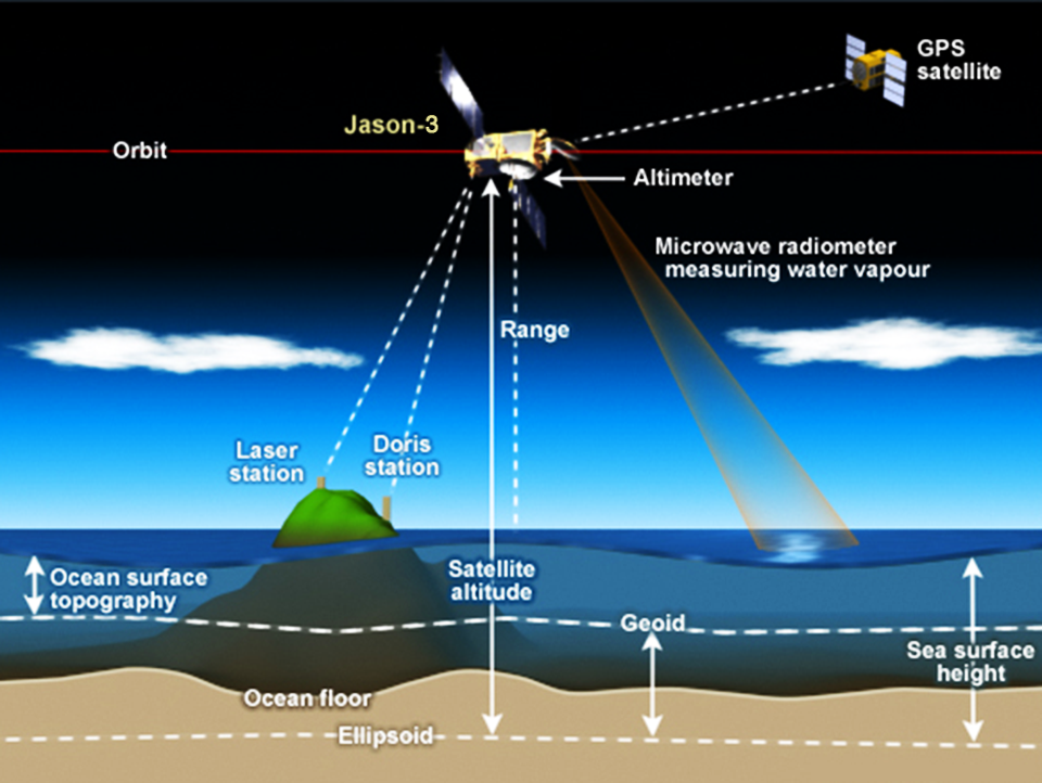
The NOAA Jason-3 satellite, orbiting the Earth, captures critical data to unlock the oceans’ mysteries and provide valuable insights into global oceanography and climate variability.
Measuring El Niño Effect at the Sea
The National Oceanic and Atmospheric Administration (NOAA) buoy mooring system is vital in monitoring and understanding the El Niño effect, a powerful climate phenomenon with far-reaching consequences. These buoy systems are strategically deployed in the ocean to collect critical data, including sea surface temperatures, wave heights, wind speeds, and atmospheric pressure. By measuring these parameters, scientists can gain insights into the complex dynamics of El Niño and its impact on global weather patterns.
Buoy Mooring System Overview
The NOAA buoy mooring system combines buoys, sensors, and mooring lines that are carefully designed to withstand the challenging marine environment. The buoys are constructed with durable materials, providing stability and flotation to support the attached instrumentation. These buoys have sensors and instruments that continuously gather data on various oceanic and atmospheric parameters.
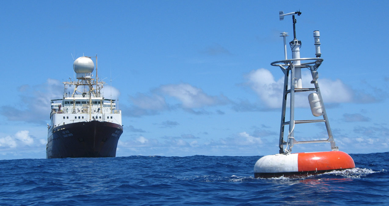
A NOAA Oceanic Buoy and ship in the background, working in harmony to gather valuable data for understanding of the marine environment.
Sea Surface Temperature Measurements
NOAA buoys have sensors that measure sea surface temperatures (SST). Above-average sea surface temperatures in the central and eastern Pacific characterize El Niño events. By monitoring SST, scientists can detect and track the development of El Niño conditions, helping to anticipate its impacts on weather patterns, marine ecosystems, and fisheries.
Wave Height and Wind Speed Measurements
Another crucial aspect of the NOAA buoy mooring system is the measurement of wave heights and wind speeds. El Niño events often influence wave patterns and wind regimes, which can have significant implications for coastal areas, maritime activities, and the intensity of storms. By monitoring wave heights and wind speeds, scientists can assess the changes associated with El Niño and provide valuable data for weather forecasting and storm preparedness.
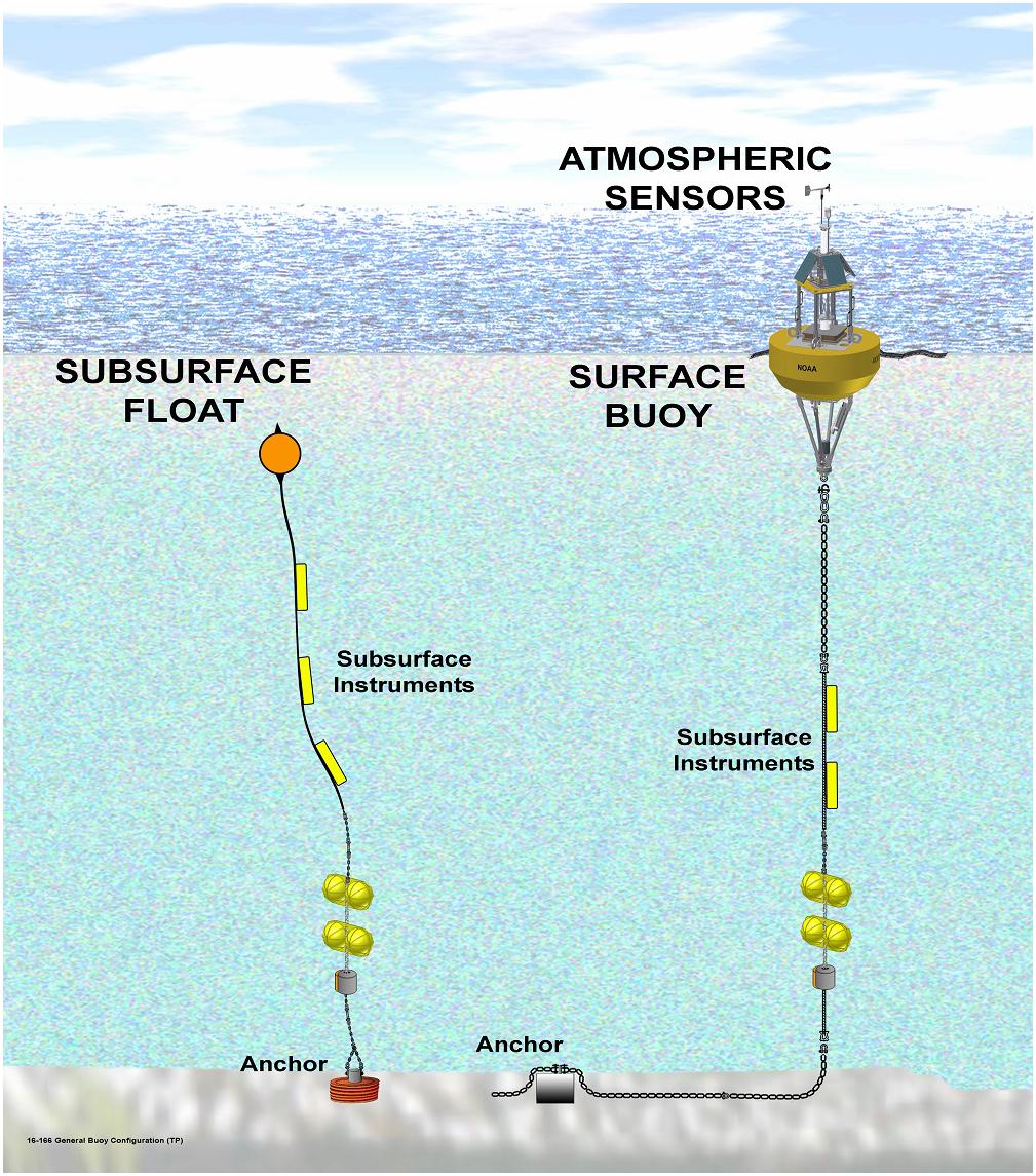
The essential components of a buoy system, including sensors, and mooring lines, work together to collect crucial oceanic data.
Atmospheric Pressure Monitoring
Changes in atmospheric pressure are also closely monitored by the NOAA buoy mooring system. El Niño events can cause shifts in atmospheric pressure patterns, influencing global circulation and weather systems. The buoys are equipped with instruments that measure atmospheric pressure, helping scientists understand the atmospheric dynamics associated with El Niño and its effects on regional and global climate patterns.
Data Transmission and Analysis
The data collected by the NOAA buoy mooring system is transmitted in real-time to research centers and weather agencies for analysis. Sophisticated data processing techniques and models are applied to interpret the information gathered by the buoys. Scientists analyze the data to identify El Niño patterns, track its evolution, and assess its potential impacts on weather, climate, and ecosystems. In addition to direct measurements, meteorologists rely on sophisticated computer models to simulate and predict El Niño.
Weather forecasting models simulate El Niño by incorporating various factors contributing to this climatic phenomenon’s development and progression. These models utilize complex mathematical equations to represent the physical processes that govern the atmosphere and oceans.
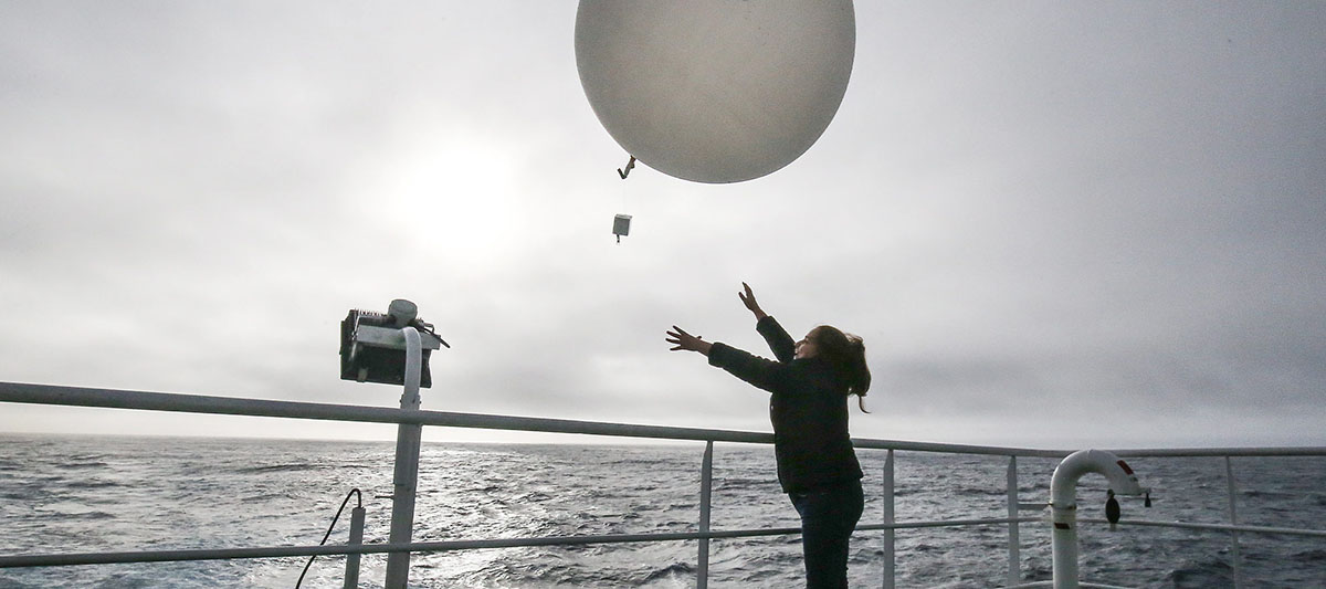
Launching a Weather Balloon into the Atmosphere for Scientific Exploration
When simulating El Niño, meteorologists input initial conditions based on current atmospheric and oceanic states, such as sea surface temperatures, wind patterns, and air pressure readings. These initial conditions serve as the starting point for the model simulations.
As the models run, they solve the equations iteratively, projecting the evolution of atmospheric and oceanic conditions over time. The models consider the interactions between the atmosphere and the ocean, including heat exchange, moisture, and momentum. They also incorporate feedback mechanisms, such as the positive feedback between warm sea surface temperatures and reduced trade winds, characteristic of El Niño events.
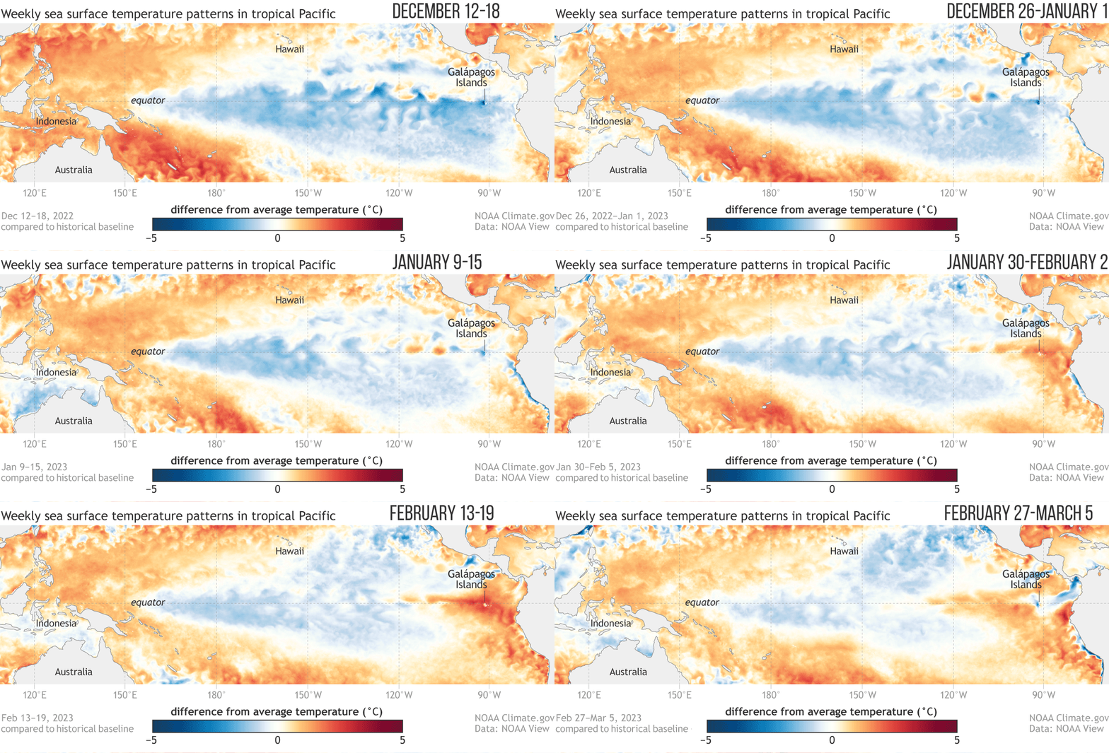
Animation of SST over the Pacific Area for the last few weeks.
Through the simulation process, the models generate forecasts of future states of the atmosphere and oceans, including the duration, intensity, and spatial extent of El Niño events. These forecasts provide valuable information for understanding the potential impacts of El Niño on regional and global weather patterns.
Weather forecasting models for El Niño are typically based on numerical techniques known as coupled general circulation models (CGCMs) or coupled ocean-atmosphere models. CGCMs simulate the interactions between the atmosphere and the ocean, capturing the complex dynamics involved in El Niño. These models utilize grids that divide the Earth’s surface into discrete points, allowing for the representation of spatial variations in atmospheric and oceanic conditions.
Weather forecasting models undergo constant refinement and calibration based on observations and historical data to ensure accuracy. Scientists compare model outputs with real-world observations to assess their performance and make necessary adjustments to improve their reliability.
It’s important to note that while weather forecasting models have significantly improved our understanding and prediction of El Niño, there are still inherent uncertainties associated with these simulations. El Niño is a complex and dynamic phenomenon influenced by multiple factors, and accurately capturing all its intricacies in a model can be challenging. Therefore, ongoing research and advancements in modeling techniques are essential to enhance further our ability to forecast and mitigate the impacts of El Niño.
Now, let’s explore how global climate change affects El Niño both currently and in the future.
Intensification and Frequency
Studies suggest that global climate change may intensify El Niño events in terms of their strength and frequency. Warmer ocean temperatures associated with climate change can provide favorable conditions for the development and persistence of El Niño. This intensification could lead to more frequent and potentially stronger El Niño events, further impacting worldwide weather patterns and climate variability.
Altered Spatial Patterns
Climate change may also influence the spatial patterns of El Niño impacts. While El Niño traditionally affects specific regions, such as the Pacific Rim, changes in atmospheric circulation due to global warming could cause El Niño-related weather anomalies to shift and extend to other regions. This could result in modified rainfall patterns, temperature extremes, and ecosystem disruptions in previously unaffected areas.
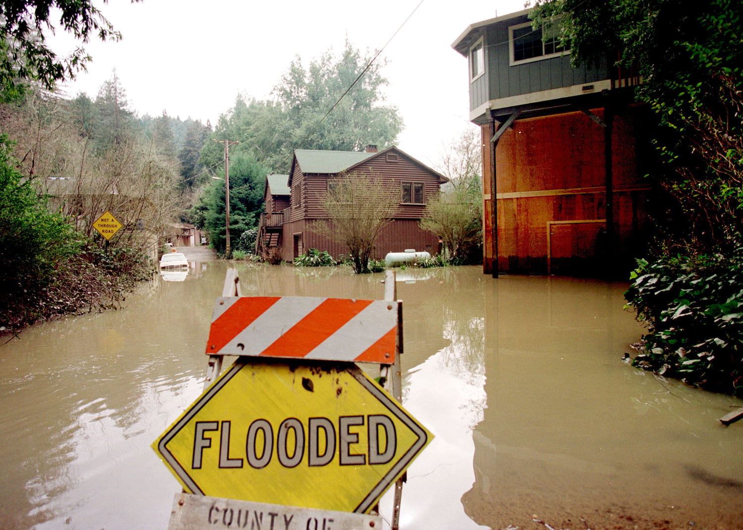
Heavy rainfall and overflowing rivers have caused widespread flooding, submerging roads, homes, and fields in water.
Feedback Mechanisms
El Niño and global climate change can interact through feedback mechanisms. El Niño events affect atmospheric and oceanic conditions, and these changes can, in turn, influence global climate patterns. For instance, El Niño can affect the distribution of heat and moisture in the atmosphere, potentially impacting regional and global temperatures. Understanding these feedback mechanisms is crucial for accurately assessing the long-term effects of El Niño and climate change.
It’s important to note that the precise impacts of global climate change on El Niño are still subjects of ongoing research and scientific investigation. While evidence points towards potential changes, the exact nature and magnitude require further study and modeling efforts. Continued research will help refine our understanding of the complex relationship between El Niño and climate change, aiding in more accurate predictions of future climate conditions.
Conclusion
Over the past 30 years, the study of El Niño has witnessed remarkable advancements in our understanding of this complex weather phenomenon. Through the diligent efforts of meteorologists and climate scientists, we have unraveled the intricate connections between oceanic and atmospheric conditions during El Niño events.
Armed with this knowledge, we are better equipped to predict and prepare for the far-reaching consequences of El Niño, ranging from altered rainfall patterns to the increased likelihood of extreme weather events. As we continue to unlock the secrets of El Niño, we enhance our ability to mitigate its impacts and safeguard communities worldwide.
spaceflight101.com, Frontiersin.org, climate.gov, NOAA.gov, and mongabay.com provided images used in this article.