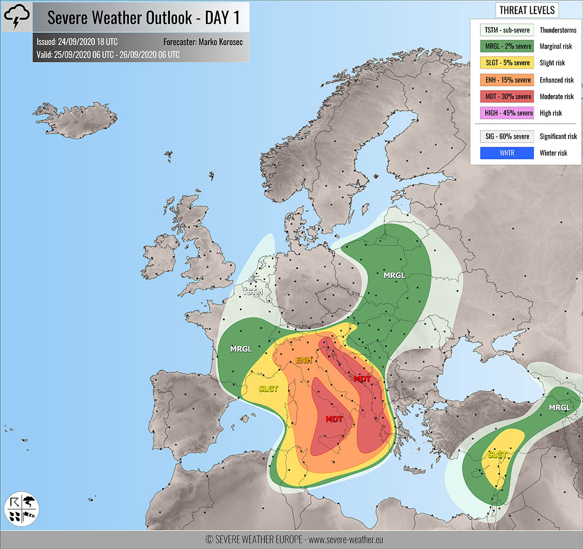
Severe weather outlook – forecast across Europe. This forecast features areas of organized severe weather with risk levels and severe weather threats across the European continent.
SEVERE WEATHER OUTLOOK – DAY 1
Valid: 25/09/2020 06 UTC – 26/09/2020 06 UTC
Issued by: Severe Weather Europe
Forecaster: Marko Korošec
SUMMARY
Widespread severe storms including supercells with torrential/excessive rainfall, severe winds, tornadoes, and large hail are expected across the Mediterranean, Italy, and western Balkan peninsula on Friday. High rainfall sums are likely along with the Dynaric mountain range and the southern Apennines and lead to flash floods.
Overview of the risk areas across Europe
SYNOPTIC OVERVIEW
A very deep long-wave upper trough is moving across central Europe and the northern Mediterranean, gradually transforming into an intense and large upper low. Strong upper ridges are maintained over the North Atlantic and northwestern Russia. Short-wave pushes into the Middle East.
FORECAST DISCUSSION
+++ Italy, Austria, Slovenia, Croatia, Bosnia, Montenegro, Albania and Greece +++
MDT risk has been issued for northeast Italy, western Slovenia, western Croatia, western Bosnia, Montenegro, Albania, and western Greece with a threat for widespread severe storms. Those will be capable of producing torrential/excessive rainfall with flash floods, severe winds, large hail, and tornadoes.
MDT risk has been issued for the Tyrrhenian Sea and south-central Italy with a threat for severe storms with large hail, severe winds, tornadoes, and torrential/excessive rainfall.
Large scale upper-level forcing will result in widespread organized severe storms, including intense supercells.
Storms are expected to partly continue from the previous night (Friday morning) onwards over the western Balkan and north-central Italy and re-intensify/develop during the day.
Strong shear coupled with strong instability (MLCAPE 1000-2000 J/kg) will support widespread organized storms, including severe supercells.
Enhanced low-level shear and helicity should also introduce the tornadic environment along the eastern Tyrrhenian Sea coast, the eastern Adriatic, and the Ionian Sea. Tornadoes (strong waterspouts) could form and come ashore.
Intense rainfall will develop with any organized storm as impressive moisture is present over the Mediterranean, combined with unstable air mass. Torrential rainfall will lead to flash floods.
Rainfall sums could reach 100-200 mm, potentially even close to 250 mm across the MDT risk areas. A combination of both persistent strong orographic and convective rainfall. Training storms could produce an extreme amount of rain in a short time and locally lead to dangerous flooding.
ENH/SLGT risks have been issued for the areas surrounding the MDT risks across the north-central Mediterranean and western Balkan peninsula with a more isolated threat but a still severe threat for organized storms.
Isolated to scattered supercells are likely, posing threat for large hail, severe winds, and torrential rainfall events.
SLGT risk has been extended over the northwestern Mediterranean with a threat for non-convective severe downslope winds, gusting up to around 120 km/h locally.
Those will be capable of producing severe winds, marginal hail, and torrential/excessive rainfall.
Storms are expected to cluster into large systems (MCS) in the evening hours, spreading east-southeast overnight to Saturday across both MDT risk areas.
+++ Turkey, Cyprus and Syria +++
SLGT risk has been issued for southern Turkey into eastern Cyprus and northwestern Syria with isolated threat for severe storms, capable of producing severe winds, large hail, and torrential rainfall.
+++ other areas +++
MRGL/TSTM risks have been issued for parts of eastern Europe, eastern Turkey, and Benelux with a threat for daytime driven storms. Limited shear is present, so the storms should be less organized and mostly remain sub-severe.
Follow & report severe weather events on our Facebook page:
Severe Weather Europe Facebook page
Understanding Severe Weather Outlook
Severe Weather Outlook features areas of organized severe weather with risk levels and severe weather threats. Risk levels are divided into seven categories:
TSTM – Thunderstorms
MRGL – Marginal risk
SLGT – Slight risk
ENH – Enhanced risk
MDT – Moderate risk
HIGH – High risk
SIG – Significant risk
WNTR – Winter risk
Risk categories stand for the coverage and intensity of organized severe weather. Those could include supercells, squall lines, mesoscale convective systems, wind storms, flooding, snowstorms, or ice storms.
Severe weather threats include:
- large hail (of at least 2 cm in diameter)
- Tornadoes (including waterspouts)
- Wind gusts (convective or non-convective) above 25 m/s (or above 90 km/h)
- Torrential convective precipitation / Flash floods
- Excessive rainfall (100 mm within 12 hours) / snowfall (50 cm within 12 hours)
Extremely severe weather threats include:
- Large hail (of at least 5 cm in diameter)
- Tornadoes of F2 intensity or stronger
- Wind gusts (convective or non-convective) above 33 m/s (or above 119 km/h) or 12 Bft
- Torrential convective precipitation / Flash floods
- Excessive rainfall (150 mm within 12 hours or above ) / snowfall (above 100 cm within 24 hours)
Categories in the forecast represent the chance of severe weather occurring within a 40 km radius from a location. The used level is based on the conversion table of probabilistic risk into the outlook categories. A threat level is upgraded into a higher category if probabilities meet the threshold criteria for the specific threat (e.g. tornado, wind, hail, or rainfall threat).
Each individual threat area includes a detailed forecast map and discussion on the potential of severe weather threats.
Read more: Explanations for abbreviations (TSTM, SLGT, ENH, etc.)


