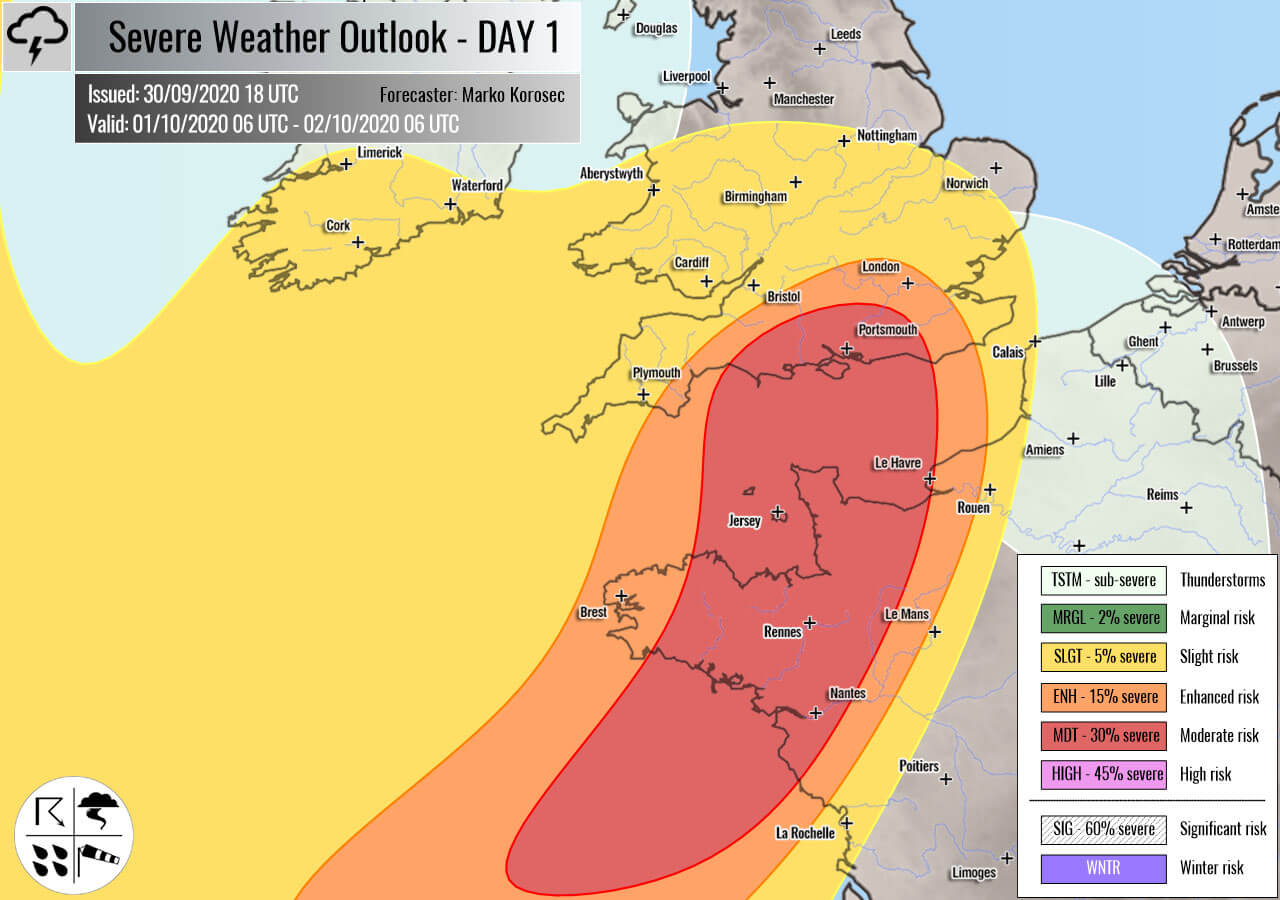
Severe weather outlook – forecast across Europe. This forecast features areas of organized severe weather with risk levels and severe weather threats across the European continent.
SEVERE WEATHER OUTLOOK – DAY 1
Valid: 01/10/2020 06 UTC – 02/10/2020 06 UTC
Issued by: Severe Weather Europe
Forecaster: Marko Korošec
SUMMARY
Severe damaging winds and torrential rainfall are expected along with the rapidly developing storm Alex from the Bay of Biscay into northwestern France and across the English Channel into southern England. Severe storms are possible across eastern Turkey and the southern Mediterranean.
Overview of the risk areas across Europe
SYNOPTIC OVERVIEW
An upper ridge is strengthening over northern Europe and northwestern Russia. Another strong ridge persists over the Azores and North Atlantic. In between, a rapidly developing deep upper low enters western Europe with an associated intense surface low forming over the Bay of Biscay. Cyclone travels into the English Channel while deepening and curves back south to northwestern France on Friday morning. Another upper low is decaying over the southern Balkan peninsula.
FORECAST DISCUSSION
+++ France, England and English Channel +++
MDT risk has been issued for northwestern France and across the English Channel into southern England with a threat for severe damaging winds, torrential rainfall, and some tornado threat.
ENH/SLGT risks have been issued for areas surrounding the MDT risk with a threat for severe winds and torrential rainfall.
A rapidly developing surface low – a storm Alex – will introduce very dangerous and intense winds threat. A narrow band of extremely severe winds is likely across the MDT risk area.
Peak gusts could exceed 130 km/h over northwestern France, while 100-120 km/h gusts seem possible further north across the English Channel and southern England.
Hurricane-force winds are possible over Brittany region, France.
With the arrival of the stronger jet, very strong shear and low-level helicity will develop along the leading cold front. Therefore, some tornado threats could result in northwestern France.
Torrential rainfall is expected along the leading cold front entering the MDT/ENH risk areas from the west-southwest through the evening hours. Threat continues overnight with the front progress towards the northeast.
Locally high rainfall amounts are expected, possibly reaching near 80-100 mm over the 24 hour period.
Mesocale discussion: An intense storm Alex is now forecast to strike Brittany and England with severe damaging winds this Friday
+++ Turkey and Georgia +++
SLGT risk has been issued for eastern Turkey into Georgia with a threat for severe storms, capable of producing severe winds, large hail, and torrential rainfall.
+++ other areas +++
MRGL risk has been issued for southern Italy and Malta with an isolated threat for severe storms, capable of producing severe winds, large hail, and torrential rainfall.
TSTM risks have been issued for southern Ukraine, northwestern Mediterranean, Ireland, Northern Ireland, and western Scotland with a threat for daytime driven storms. Limited shear is present, so the storms should remain sub-severe.
Follow & report severe weather events on our Facebook page:
Severe Weather Europe Facebook page
Understanding Severe Weather Outlook
Severe Weather Outlook features areas of organized severe weather with risk levels and severe weather threats. Risk levels are divided into seven categories:
TSTM – Thunderstorms
MRGL – Marginal risk
SLGT – Slight risk
ENH – Enhanced risk
MDT – Moderate risk
HIGH – High risk
SIG – Significant risk
WNTR – Winter risk
Risk categories stand for the coverage and intensity of organized severe weather. Those could include supercells, squall lines, mesoscale convective systems, wind storms, flooding, snowstorms, or ice storms.
Severe weather threats include:
- large hail (of at least 2 cm in diameter)
- Tornadoes (including waterspouts)
- Wind gusts (convective or non-convective) above 25 m/s (or above 90 km/h)
- Torrential convective precipitation / Flash floods
- Excessive rainfall (100 mm within 12 hours) / snowfall (50 cm within 12 hours)
Extremely severe weather threats include:
- Large hail (of at least 5 cm in diameter)
- Tornadoes of F2 intensity or stronger
- Wind gusts (convective or non-convective) above 33 m/s (or above 119 km/h) or 12 Bft
- Torrential convective precipitation / Flash floods
- Excessive rainfall (150 mm within 12 hours or above ) / snowfall (above 100 cm within 24 hours)
Categories in the forecast represent the chance of severe weather occurring within a 40 km radius from a location. The used level is based on the conversion table of probabilistic risk into the outlook categories. A threat level is upgraded into a higher category if probabilities meet the threshold criteria for the specific threat (e.g. tornado, wind, hail, or rainfall threat).
Each individual threat area includes a detailed forecast map and discussion on the potential of severe weather threats.
Read more: Explanations for abbreviations (TSTM, SLGT, ENH, etc.)


