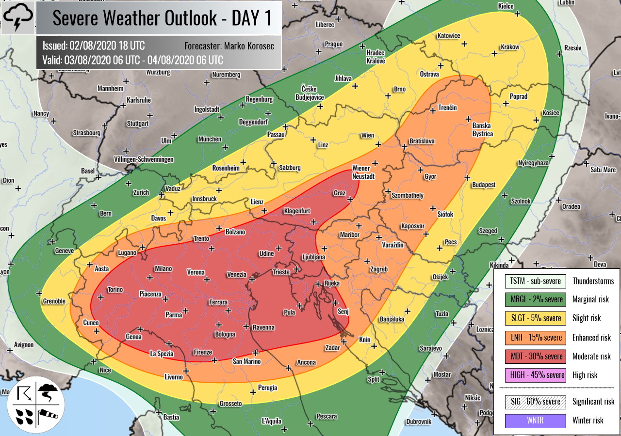
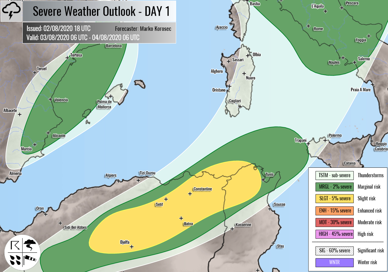
Severe weather outlook – forecast across Europe. This forecast features areas of organized severe weather with risk levels and severe weather threats across the European continent.
SEVERE WEATHER OUTLOOK – DAY 1
Valid: 03/08/2020 06 UTC – 04/08/2020 06 UTC
Issued by: Severe Weather Europe
Forecaster: Marko Korošec
SUMMARY
Severe thunderstorms including intense supercells with a threat for severe winds, tornadoes, large hail, and torrential rainfall with flash floods are likely across north Italy, western Slovenia, and northwest Croatia on Monday.
Overview of the risk areas across Europe
SYNOPTIC OVERVIEW
A progressive pattern has developed over Europe. A large long-wave trough is deepening while moving towards south-central Europe. An upper ridge strengthens across southeast Europe in western Russia. At the surface, a frontal boundary is extending from central Scandinavia towards the Alps. A surface depression forms over northern Italy.
FORECAST DISCUSSION
+++ SE Switzerland, N Italy, S Germany, E Czechia, S Poland, Slovakia, Hungary, Austria, Slovenia and Croatia +++
MDT risk has been issued for north Italy, west Slovenia, south Austria, and northwest Croatia with a threat for severe storms, capable of producing severe winds, tornadoes, large to very large hail, and torrential/excessive rainfall with flash floods.
ENH/SLGT risks have been issued for areas surrounding the MDT risk area including the Alpine and north Adriatic regions and northern Balkan peninsula. A threat for severe winds, large hail, and torrential rainfall will develop.
A scattered to widespread organized severe storms are expected to develop along with the moving frontal wave from west to east. The environmental conditions are supportive of the rapid development of the storms all day. The afternoon evolution is strongly dependant on the overnight activity as a large cluster of severe storms will already be possible in the morning hours.
A strongly to extremely unstable air mass and moderately sheared environment is present in the forecast MDT/ENH risk areas, especially over northern Italy and north Adriatic region into western Slovenia and northwest Croatia. 2500-3000 J/kg of CAPE is locally likely to build up, overlapped with 40-50 knots of deep-layer shear.
Conditions will be conducive for severe rotating storms to develop. A few intense supercells with large hail and severe winds are expected. Moderately strong southeasterly low-level flow should bring high moisture from the warm Adriatic into the north Italy plains.
Locally strongly enhanced helicity could support tornado threat. Especially across the eastern Po valley and Veneto region. This area is being monitored for a possible upgrade into higher categorical risk if conditions become more clear and robust in the late morning observations.
Another concern is the flooding threat, as very high dewpoints are present across northern Italy. Flash floods are locally quite likely given a huge amount of rainfall forecast. Also, for this reason, categorical risks have been extended into the Alps where high rainfall sums are expected.
Storms could merge into a large MCS into the Alps and north Adriatic region, racing towards the northern Balkans. This will support severe winds and excessive rainfall overnight to Tuesday.
+++ northern Algeria and Tunisia +++
SLGT risk has been issued for northern Algeria and northern Tunisia with a threat for a few isolated severe storms, capable of producing severe winds and large hail.
A moderate deep-layer shear and instability should support organized storms. Supercells will be possible.
MRGL risk has been issued around the SLGT risk area, with a marginal threat for severe storms. The coverage of storms is strongly limited.
MGRL risk has been issued for eastern Spain with a threat for some isolated storms. Moderate shear and weak instability could result in marginal hail and severe winds.
+++ other areas +++
TSTM risk areas have been placed across Benelux, parts of Scandinavia and western Russia, extreme southern Balkan, and southwestern Turkey. Convective storms are likely to occur but should remain sub-severe.
Follow & report severe weather events on our Facebook page:
Severe Weather Europe Facebook page
*******************
Understanding Severe Weather Outlook
Severe Weather Outlook features areas of organized severe weather with risk levels and severe weather threats. Risk levels are divided into seven categories:
TSTM – Thunderstorms
MRGL – Marginal risk
SLGT – Slight risk
ENH – Enhanced risk
MDT – Moderate risk
HIGH – High risk
SIG – Significant risk
WNTR – Winter risk
Risk categories stand for the coverage and intensity of organized severe weather. Those could include supercells, squall lines, mesoscale convective systems, wind storms, flooding, snowstorms, or ice storms.
Severe weather threats include:
- large hail (of at least 2 cm in diameter)
- Tornadoes (including waterspouts)
- Wind gusts (convective or non-convective) above 25 m/s (or above 90 km/h)
- Torrential convective precipitation / Flash floods
- Excessive rainfall (100 mm within 12 hours) / snowfall (50 cm within 12 hours)
Extremely severe weather threats include:
- Large hail (of at least 5 cm in diameter)
- Tornadoes of F2 intensity or stronger
- Wind gusts (convective or non-convective) above 33 m/s (or above 119 km/h) or 12 Bft
- Torrential convective precipitation / Flash floods
- Excessive rainfall (150 mm within 12 hours or above ) / snowfall (above 100 cm within 24 hours)
Categories in the forecast represent the chance of severe weather occurring within a 40 km radius from a location. The used level is based on the conversion table of probabilistic risk into the outlook categories. A threat level is upgraded into a higher category if probabilities meet the threshold criteria for the specific threat (e.g. tornado, wind, hail, or rainfall threat).
Each individual threat area includes a detailed forecast map and discussion on the potential of severe weather threats.
Read more: Explanations for abbreviations (TSTM, SLGT, ENH, etc.)


