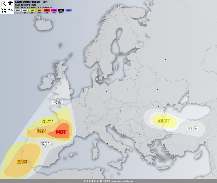
VALID FOR 06-03-2019
SYNOPSIS
A deep trough is moving across the Bay of Biscay and the Iberian peninsula while the upper ridge over south-central Europe weakens. Another deep trough moves across Fennoscandia into NW Russia. A surface cyclone is located across Ireland and the Bay of Biscay, bringing a cold front across France and the Iberian peninsula.
DISCUSSION
MDT risk has been issued for SW France and extreme N Spain into the Bay of Biscay where severe storms with threat for severe damaging winds, tornadoes, torrential rainfall with flash floods and marginally large hail are possible. A cold front pushes into several hundreds J/kg of MLCAPE within a strongly sheared environment. Supercell storms are likely to develop from the strongest cells and enhance threat for tornadoes, as strong low-level helicity will result from the very strong southerly near-surface flow from the NW Mediterranean into SW France.
ENH / SLGT risks have been issued for areas surrounding the MDT risk, including N-NW Spain, N Portugal, W France and the Bay of Biscay where some isolated threat for severe storms exist. Due to strong orographic rainfall in N Portugal and NW Spain, the excessive rainfall threat will continue.
ENH / SLGT risks have been issued for SW Iberia including south-central Portugal, SW Spain, Gibraltar and NW Morocco with threat for severe storms along the cold front. Strongly sheared environment overlapping with marginal instability should support severe winds and torrential rainfall as primary threats. However, favorable low-level shear and helicity should support tornado threat as well.
SLGT risk has been issued for eastern Romania, NE Bulgaria into the W Black Sea with threat for isolated severe storms, mainly supporting marginal hail and strong to severe winds.
TSTM risk areas have been placed where convective storms are most likely to occur. These areas include NE France, England and central Turkey as well, but lack of good instability / shear preclude better organized storms.
