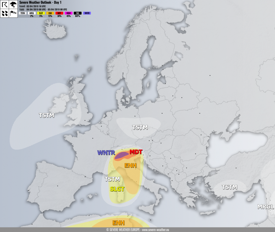
VALID FOR 04-04-2019
SYNOPSIS
A large deep upper low is located over west and southwest Europe with one vorticity maximum and an associated surface cold front pushed across the Alps and the N Mediterranean. An upper ridge dominates Arctic region. Low geopotentials persist over N Africa and thr E Mediterranean, supporting convective activity.
DISCUSSION
MDT risk has been issued for southern Alpine flank across N Italy and S Switzerland with threat for excessive rainfall, locally more than 200 mm is possible within 24 hours. A persisting southerly low-level flow will produce intense orographic rainfall, combined with convective storms due to strong frontal forcing and marginal instability within very strong shear. Local flooding threat exists.
WNTR risk has been issued for parts of NNW Italy into S Switzerland and SW Austria for an excessive snowfall above 1500 m ASL. Very intense snowfall is expected, resulting in locally more than 100-150 cm of fresh snow possible.
ENH / SLGT risks have been issued across southern Alps, N-CNTRL Mediterranean and Tyrrhenian sea with threat for severe storms along the eastwards moving cold front, capable of producing severe winds, large hail and torrential / excessive rainfall. Very strong low-level shear and helicity should also support supercells with some tornado potential where instability and shear will best overlap together. Very intense rainfall should also result in flash floods threat and locally a good hail accumulation. Widespread storm activity is expected.
ENH / SLGT risks have been issued for NE Algeria into N Tunisia and the S Mediterranean with threat for severe storms, capable of producing severe winds, large hail and torrential rainfall. Quite widespread activity is likely again.
MRGL risk has been issued for S Middle East with threat for isolated severe storms, capable of producing severe winds, heavy rainfall and marginal hail.
TSTM risk areas have been placed where convective storms are possible.
Mesoscale discussion:

