SYNOPSIS
A deep upper trough is centered over N Europe while the strong upper ridge persists over the Arctic region, expanding into the N Atlantic. A short-wave trough moves across the Alps, while another one moves across the E Mediterranean into the Middle East. One wave / low moves across Algeria towards the east.
DISCUSSION
SLGT risk has been issued for NE Italy into N Adriatic sea and WSW Slovenia with isolated threat for severe storms, capable of producing marginally large hail, severe winds and torrential rainfall. Despite limited shear, good instability could support some organized storms in the afternoon and evening hours.
SLGT risk has been issued across the E-CNTRL Balkan peninsula with the isolated threat of severe storms, capable of producing severe winds, large hail and torrential rainfall. Moderately strong instability in marginal to moderate shear should support some organized storms along the moving frontal boundary in the afternoon hours.
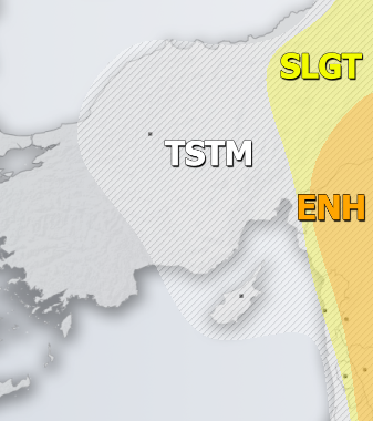
ENH risk has been issued for SE Turkey into the Middle East with threat for severe storms, capable of producing severe winds, large hail, torrential rainfall and tornadoes. Quite a good overlap of strong shear, instability and helicity should support organized severe storms, including supercells with large to very large hail and a tornado or two.
SLGT risk has been issued for the area surrounding the ENH risk including Georgia into E Turkey and the Middle East with isolated threat for severe storms, capable of producing severe winds, large hail and torrential rainfall.
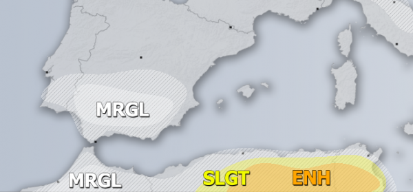
ENH / SLGT risks have been issued for NE Algeria into N Tunisia with threat for severe storms, capable of producing severe winds, large hail, torrential rainfall and tornadoes. Impressive LL helicity is strongly supportive of tornadic supercells across the risk area, together with very large hail and severe damaging winds.
MRGL risks have been issued for S Spain and N Morocco with threat for isolated severe storms, capable of producing torrential rainfall, marginal hail with accumulation and strong to severe winds.
TSTM risk areas have been placed where convective storms are likely to occur but should remain sub-severe.


