First long-range forecasts for Spring are now available, and they show a breakdown of the El Niño anomaly in the Pacific. But its influence will remain strong enough to impact the Spring over the United States and, to a lesser extent, over Europe.
The El Niño event in the equatorial Pacific has reached its peak. It is expected to start its decline towards the end of winter.
Despite the breakdown of these warm ocean anomalies, their influence can still echo across the global weather circulation. Long-range weather predictions see this exact scenario with a continued El Niño influence over North America.
A DISTURBANCE IN THE ATMOSPHERE
The late 2023 has been under the influence of the strong El Niño event in the Pacific Ocean. It is an area of above-normal ocean temperatures, which reflects the changes in the atmosphere. You could say it perhaps acts as a warning light on the dashboard, indicating a certain shift in the atmosphere.
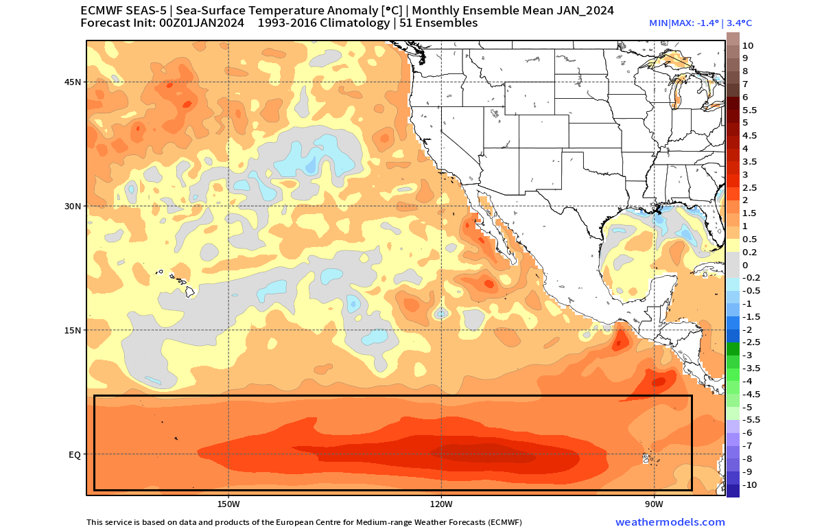
Below is also an ocean temperature forecast for January 2024. You can see the strong ocean temperature anomaly in the Pacific Ocean. The forecast shows a central/basin-wide event strong enough to have a very noticeable atmospheric impact on weather patterns.
The periodical appearance of these anomalies means that there have been several events in the past decades. This gives us an opportunity to look at past such events and how the atmosphere responded in those years.
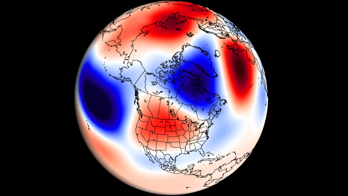
Below, you can see the average El Niño winter pressure anomalies. Notice the strong low-pressure anomaly in the North Pacific, expanding across the United States and onwards into the Atlantic.

Also, you can see the high-pressure area over Canada and the northern United States, also covering part of the poral regions.
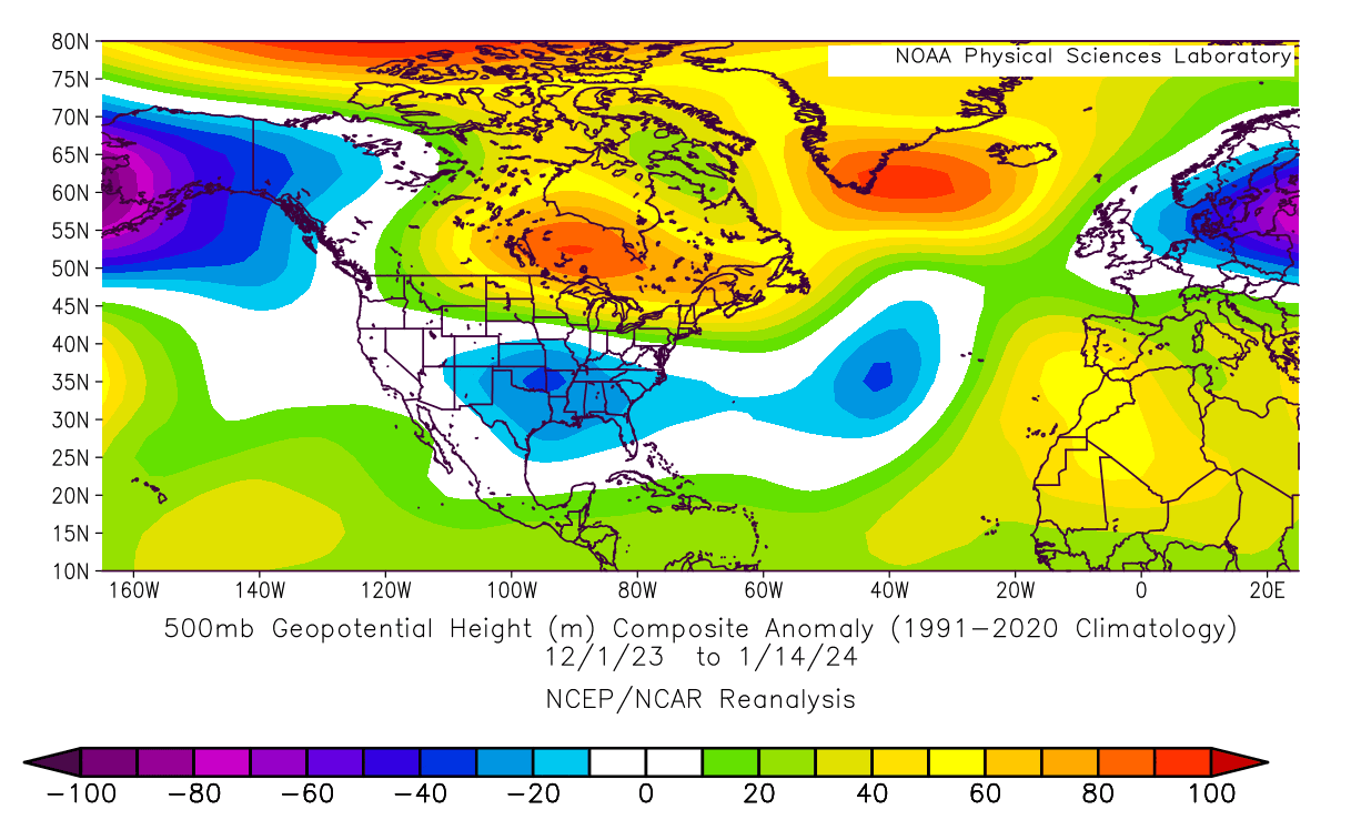
This exact pressure pattern can be seen below if we look at the analysis of winter so far, combining December and half of January pressure anomalies. Notice the strong low-pressure system over the North Pacific, typical of the El Niño, and low-pressure anomaly across the United States and northern Europe.
This way, the atmosphere speaks to us, revealing the strong impact of the El Niño event in late 2023 and early 2024, which is likely to transfer into Spring. But, a rapid shift is expected in the oceans as the El Niño begins to decline.
Below, you can see the ocean temperature forecast for the ENSO regions, which shows a rapid decrease in ocean temperatures, indicating a breakdown of the El Niño event.

You can also see this in the ocean anomaly forecast below, covering the April-June period. Notice the cold ocean anomalies starting to develop over the tropical Pacific Ocean as a new shift begins in the ENSO regions.

The last time we saw such rapid change in these regions was almost a year ago, as the cold ocean anomalies were replaced by the uprise of the warm ENSO phase. You can see that process in the video below:
Such broad and rapid changes in ocean anomalies are a clear sign of large-scale changes also coming into the atmosphere.
The latest forecast above shows that the El Niño influence will gradually start to decline at the end of winter. But as you will see in the long-range forecast below, its impact will continue to spread across the atmosphere, deep into the spring.
SPRING 2024 – FIRST SEASONAL FORECAST
For the first look at the Spring 2024 forecasts, we decided to use two main (or most used) seasonal models. The ECMWF from Europe, and the CFSv2 from the United States. Graphics are from ECMWF and the CPC/NCEP.
All these forecasts show an average picture over three meteorological spring months (March-April-May) and show the prevailing weather patterns.
Even if the models were completely accurate, it does not mean that such weather conditions would last for three months straight. It only suggests how the weather patterns might look 40-60% of the time.
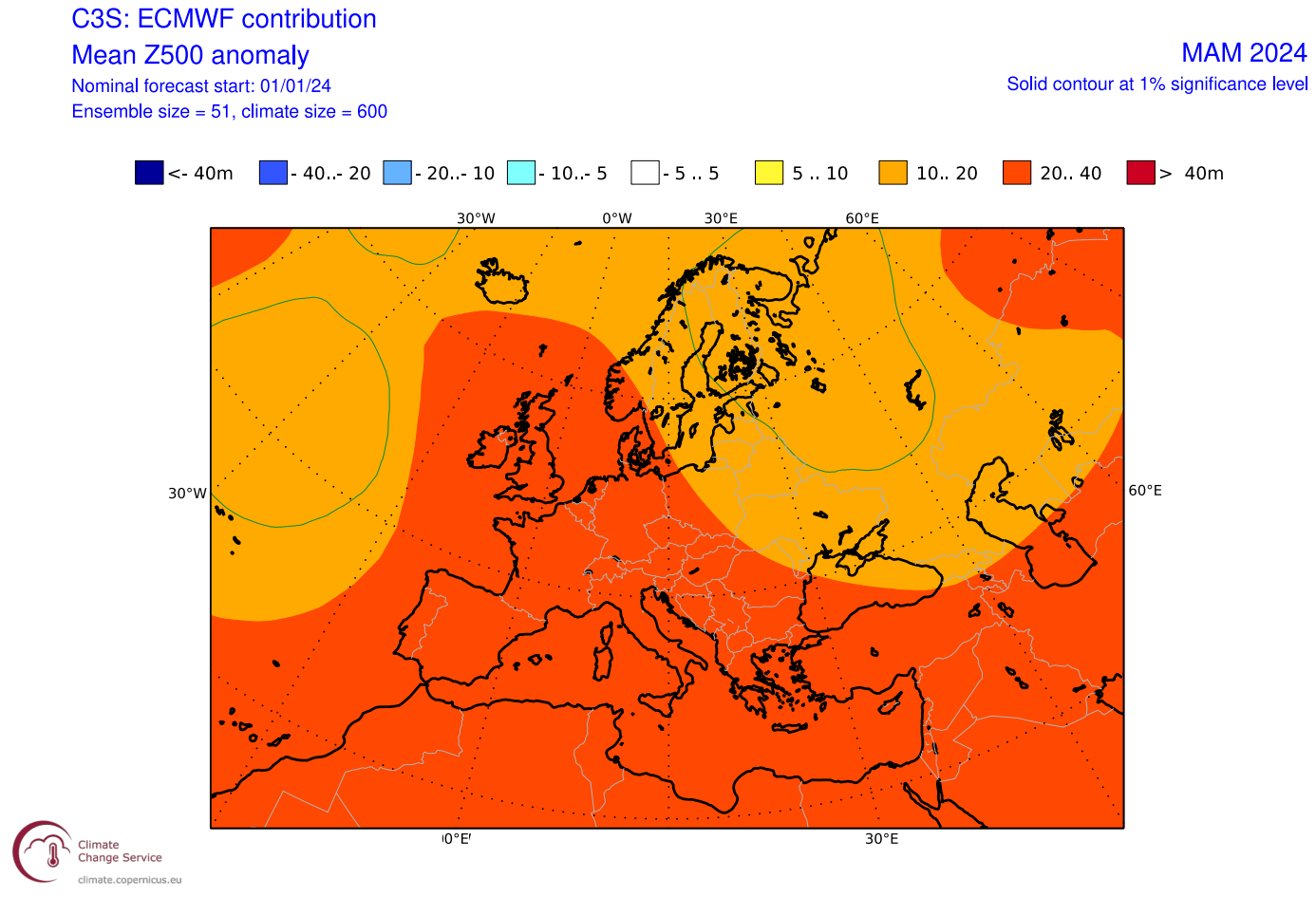
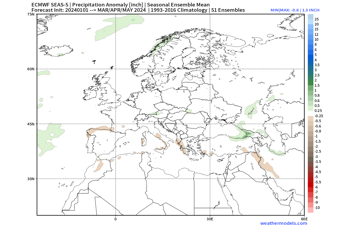
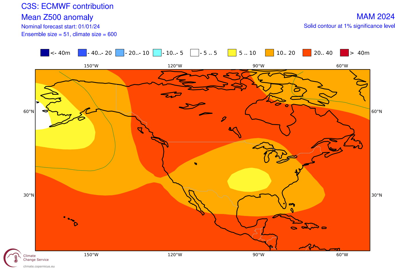
Looking at Europe first, you can see the 500mb pressure anomaly forecast for spring. The ECMWF shows a low-pressure tendency over the North Atlantic, and northern Europe, with a ridge over the west and northwest. This is similar to the weak historical signal from El Niño.
The surface temperature forecast reflects the pressure pattern and mostly above-normal temperatures. Normal to below-normal temperatures are mostly confined to the northern parts. But as we have seen every spring, cold air outbreaks tend to occur every season, especially with a low-pressure area over the north.

Precipitation-wise, there is not a strong signal seen in the forecast. There are some indications of more precipitation over the northern parts where the low-pressure area is and over the central parts. Less precipitation than normal is forecast over the southern parts.
But we can expect to see a stronger signal from the El Niño over the United States and Canada, which are under its more direct influence.
NORTH AMERICA SPRING 2024 FORECAST
The pressure pattern forecast from ECMWF below shows a very clear El Niño signature. High-pressure anomaly over Canada and the northwestern United States, and a low-pressure area over the North Pacific, extending the jet stream into the southern United States, where another low-pressure area is forecast.
The surface temperature forecast over the United States shows a warmer area for the west and northwest. You can see that the warm anomalies weaken towards the east and southeast due to the influence of the forecasted low-pressure area.

Despite being forecast warmer than normal, the central and northeastern parts of the United States tend to get occasional colder weather and snow in early Spring during El Niño seasons. That is because the cold air is still available in southern Canada, which is the main source for early spring cold air outbreaks.
The precipitation forecast below shows above-normal precipitation over much of the central and eastern United States. This is mainly due to the stronger subtropical jet stream and the presence of a low-pressure area over the eastern United States.
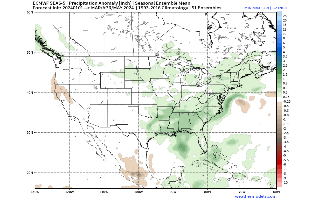
The best snowfall potential in such patterns is usually found across the northeastern and central United States and in the upper Midwest.
CFS SPRING FORECAST
In contrast to the European model, we tend to use the main North American long-range model, the CFS version 2, from the NOAA/NCEP center in the United States.
The CFS model is in agreement with the ECMWF over North America, showing the same El Niño-induced pressure pattern. High-pressure zone over Canada and the northwestern United States, and low-pressure zones over the northeast Pacific and the eastern United States.
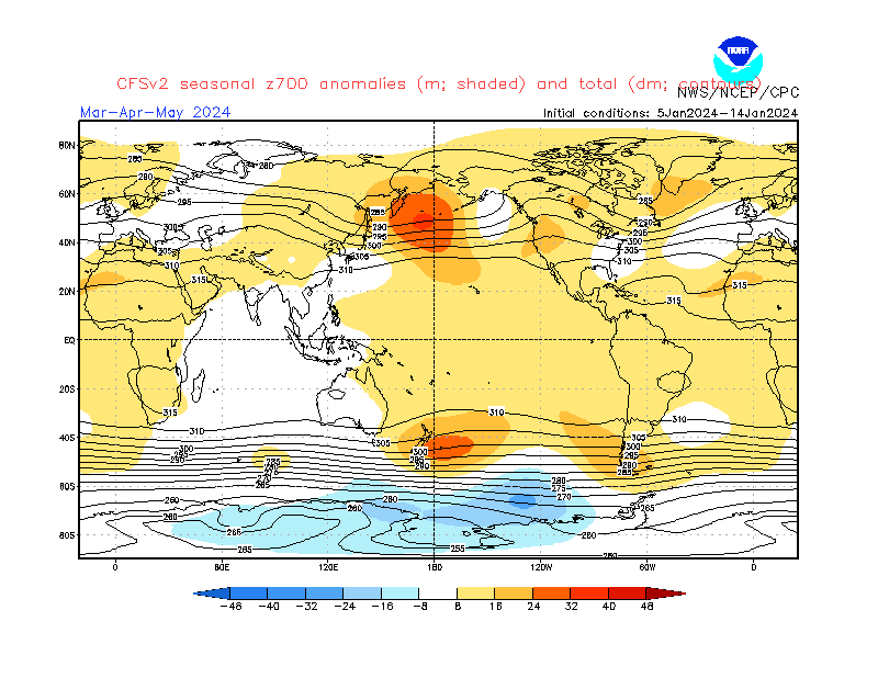
But it differs over Europe, having an opposite pattern with low-pressure over western and central Europe and high-pressure anomaly over northern parts.
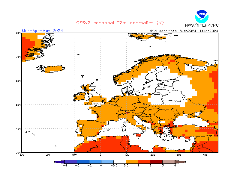
Looking first at Europe, the forecast shows above-normal temperatures over much of the region despite a tendency for lower pressure over the western and central parts.
The surface temperature forecast for North America shows a very similar pattern to the ECMWF, as is expected, given the similar pressure system position. What stands out is a region of weaker warm anomalies over the eastern United States and even a neutral zone over the southeast.
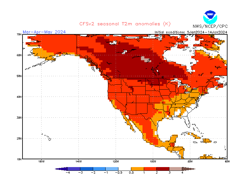
Despite looking unlikely in such an image, there are still cold air periods that occur in early spring under these patterns. Especially for the upper Midwest and the northeastern United States. This is very similar to the forecast from ECMWF.
The reason why both forecasts are similar is that both models pick up on the influence of El Niño. North America is generally under more direct impact, as it is also closer to the source region.
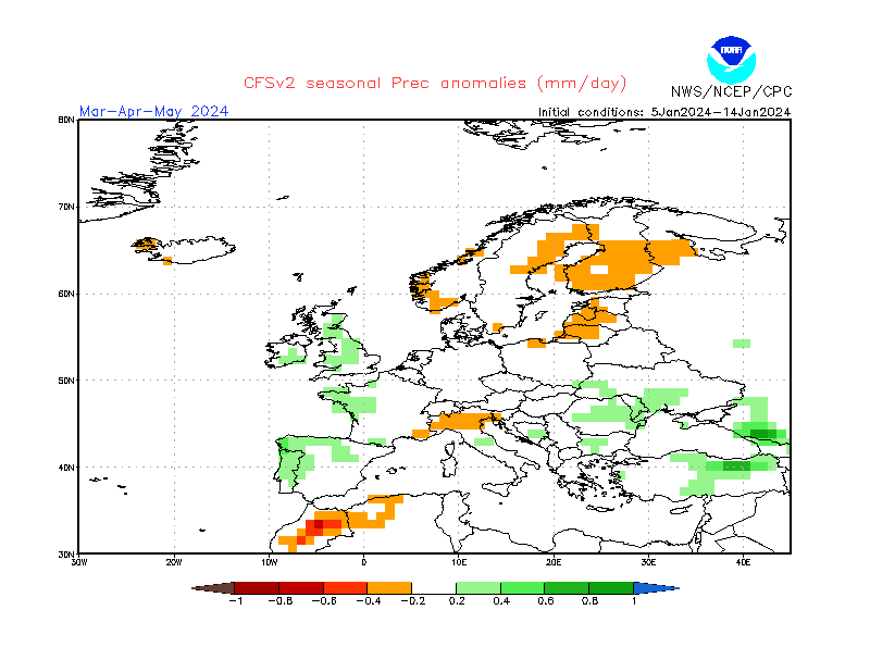
Looking at the precipitation forecast, we see less precipitation over northern and central Europe and more precipitation over the west.
Over North America, the precipitation forecast shows drier than normal conditions over the southern and western United States. This is a rather big contrast to the ECMWF, and somewhat unexpected, given the similarity in the pressure pattern forecast.
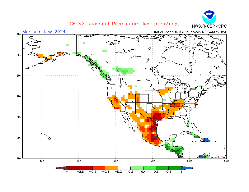
CFS is known to adjust its precipitation forecast quite a bit, and given the pressure pattern it forecasts, the ECMWF precipitation scenario seems more likely at this point.
NOAA OFFICIAL SPRING OUTLOOK
Below is the official Spring temperature forecast for the United States from NOAA. It shows the temperature probability, with colder to equal chances in the southern United States and warmer in the northern United States.
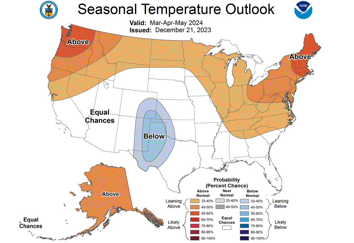
This can be interpreted by a low-pressure area over the southern to southeastern United States, driving lower temperatures to the south and warmer to the northeast.
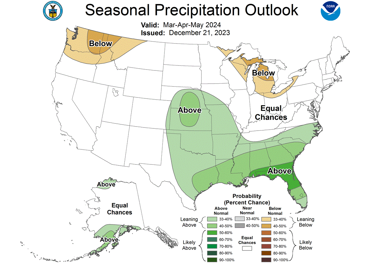
The official precipitation forecast is also quite similar to the model forecast from ECMWF. We see an equal-to-higher probability for more precipitation in the central and southeastern United States. On the other hand, the Pacific Northwest and the Great Lakes are expected to see less precipitation.
We will keep you updated on the developing weather trends in the coming seasons, so bookmark our page. Also, if you have seen this article in the Google App (Discover) feed, click the like button (♥) there to see more of our forecasts and our latest articles on weather and nature in general.
Don’t miss: