Latest forecasts show a surprising return of La Niña, expected to emerge during the Fall season as a weak to moderate event. Early predictions already show a possible impact on seasonal weather patterns, especially during Winter 2025/2026, across the United States, Canada, and Europe.
La Niña is known to disrupt the jet stream and global weather patterns, making its return significant for long-range forecasting.
In this article, we will look at the developing Pacific anomalies and their forecast, how La Niña impacts the Winter weather patterns, and show why we need to watch the Polar Vortex more closely in the 2025/2026 season, due to La Niña.
ENSO AND GLOBAL WEATHER
The La Niña is a cold phase of the ENSO phenomenon, which stands for “El Niño Southern Oscillation.” This is a region of the Pacific Ocean that periodically shifts between warm and cold phases. Typically, there is a phase change around every 1-3 years.
Each phase (cold/warm) usually develops between late summer and Fall and typically lasts until Spring. But some events can last up to two or three years, as we have seen in some of the past winters.
The cold ENSO phase is called La Niña, and the warm phase is El Niño. Besides the temperatures, one of the main differences between the phases is the pressure patterns they develop, seen below as high (H) and low (L) pressure zones in the Pacific.
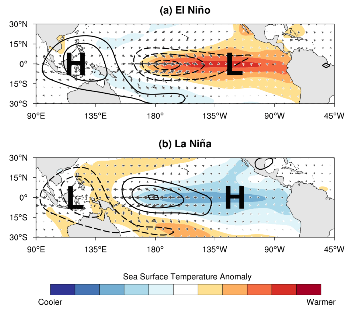
The pressure over the tropical Pacific is lower during an El Niño, with more rainfall and storms in this region.
But during a La Niña, the pressure is higher over the region, creating stable conditions and fewer storms over the equatorial Pacific. These pressure changes translate into global circulation over time, affecting seasonal weather over both Hemispheres.
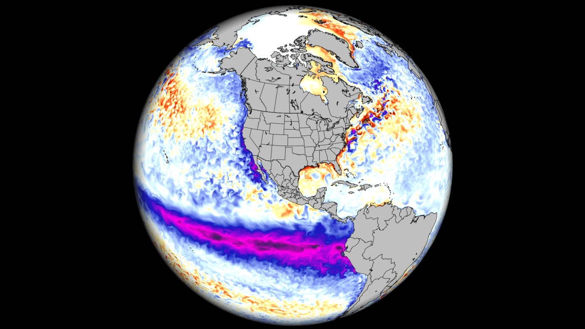
Both ENSO phases significantly influence tropical rainfall, pressure patterns, and the complex connections between the ocean and atmosphere. The image below shows the circulation pattern of a cold phase, which is forecast to influence the upcoming Winter season.
By impacting or changing this circulation, ENSO significantly changes tropical rainfall and pressure patterns. This impacts the atmosphere-ocean feedback system, which expands the ENSO influence globally, shaping the Winter temperature and snowfall patterns over North America and other regions.
We are currently in a neutral phase, coming out of a weak La Niña from the last Winter. But while the oceans are currently calm, the latest forecasts show something stirring for the Fall and Winter seasons.
THE NEUTRAL WEATHER PERIOD
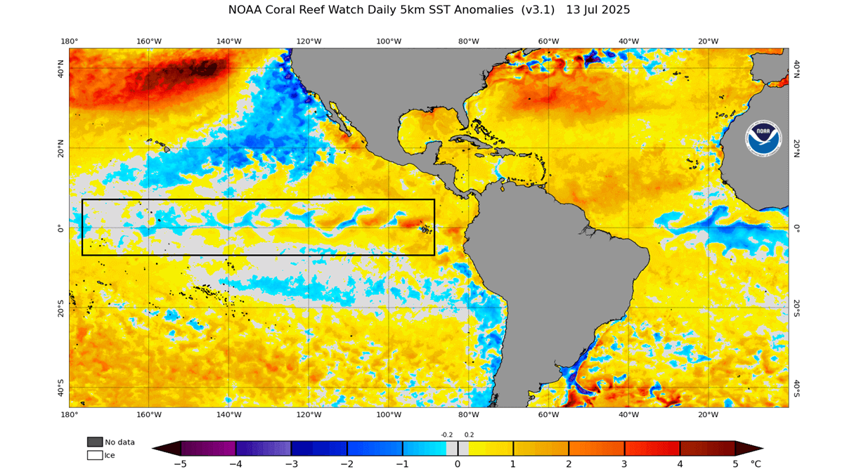
Below is the latest ocean temperature anomaly from NOAA CRW, and you can see mixed anomalies in the marked ENSO area. This is neither a proper cold nor a warm phase, and shows that a completely neutral phase is currently active. You can also see the rare cold “Atlantic Nina” in the tropical Atlantic area.
We also produced a video below, from the latest ocean data. The video shows changing ocean anomalies in the past 30 days, where you can see how the temperatures change across the ocean surface.
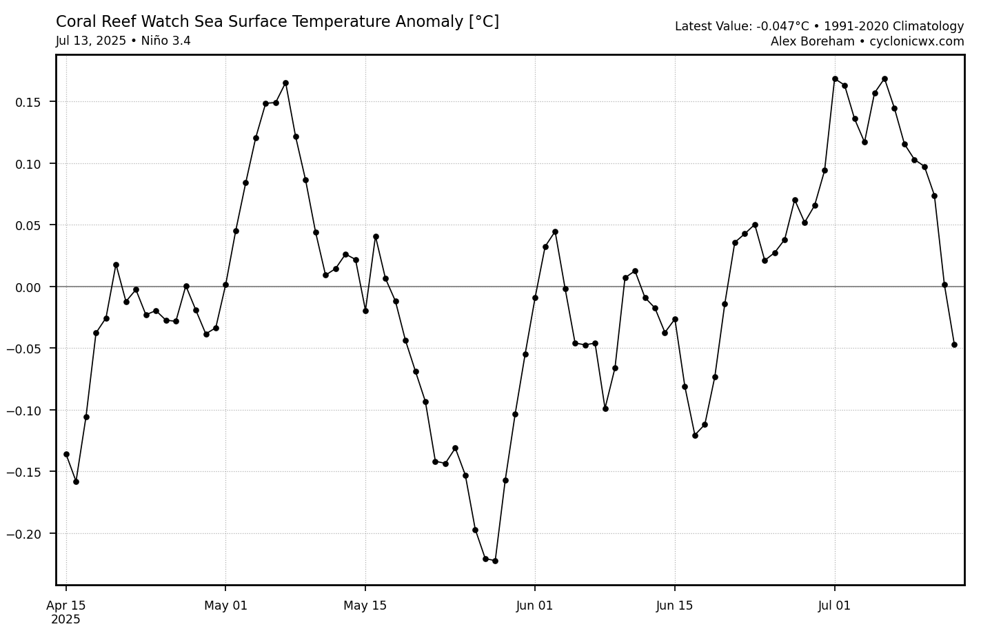
The graph below shows the ocean temperature anomaly for the main ENSO 3.4 region. It properly shows and confirms the neutral phase, as the values since April move only within 0.2 in both cold and warm directions. This is far from any true cold (warm) phase threshold of -0.5 (+0.5), which also has to be sustained seasonally beyond that threshold.
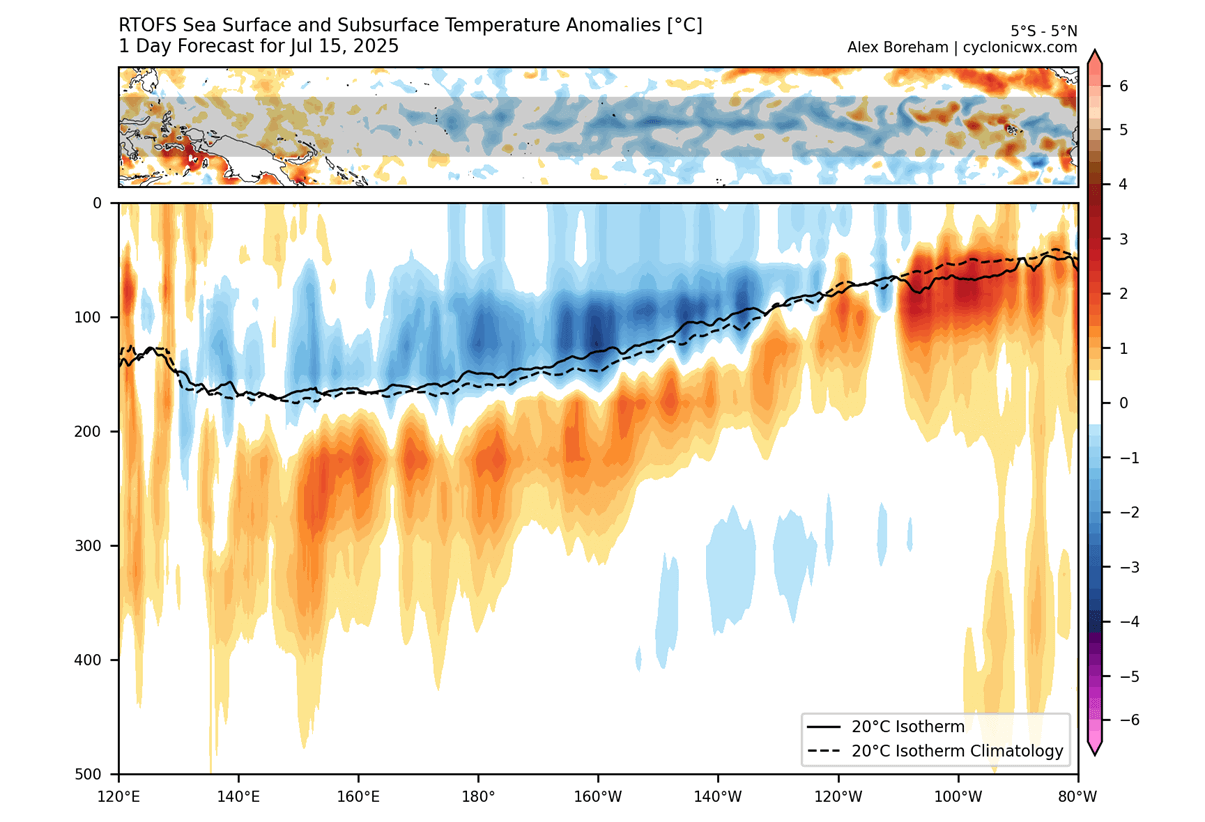
The activity below the ocean surface is also very important in this story. The image below shows the ocean temperature anomaly by depth. The cold pool of the La Niña is still visible in the central Pacific Basin, extending to depths of around 150m (500ft). But its surface features have been eroded, with warmer subsurface waters in the far eastern area.
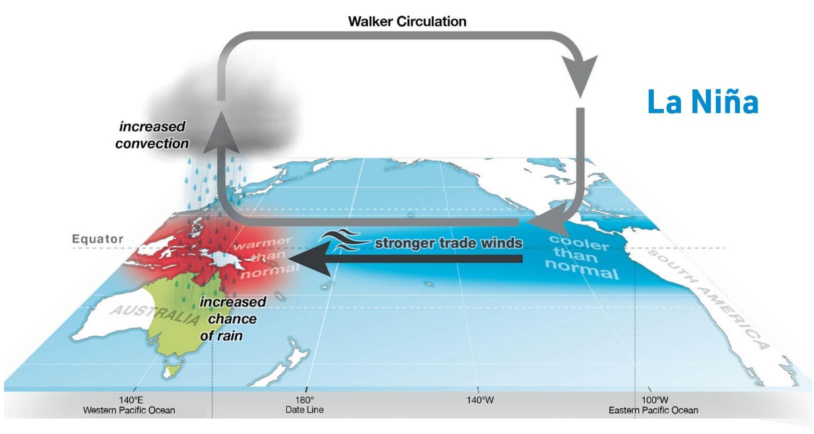
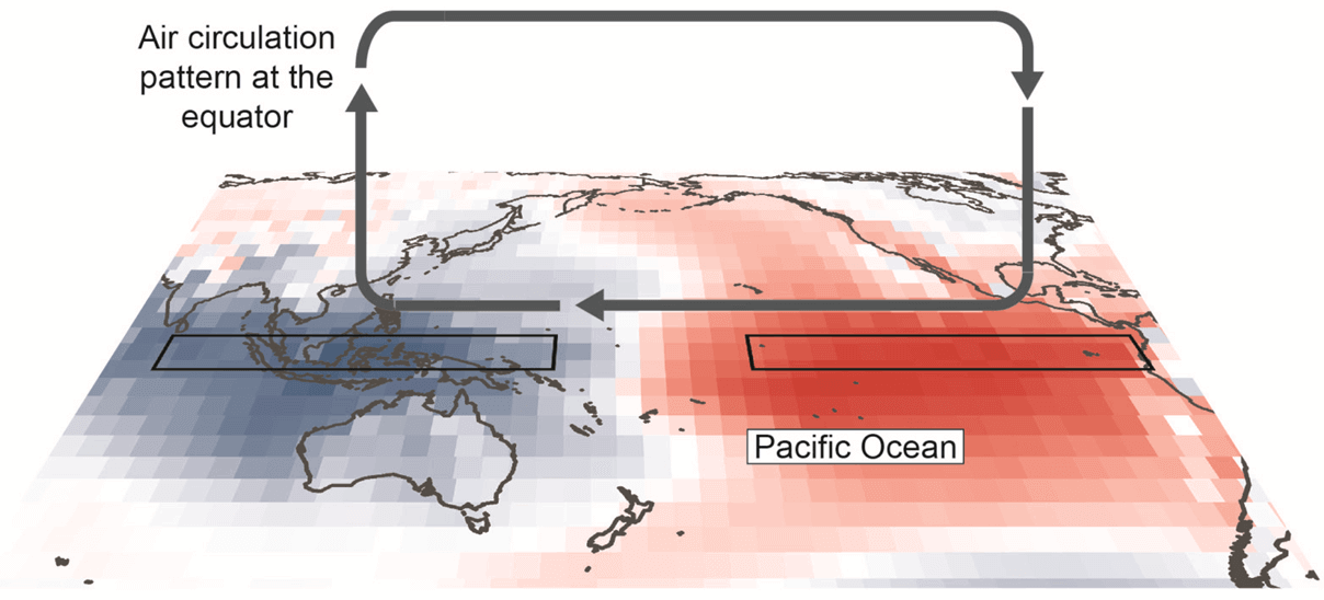
But the ENSO signature is also found in the atmosphere, not just the ocean. We can usually see the “fingerprint” of a certain phase in the so-called Walker Circulation. This is an “atmospheric loop”, with the air motion from east to west over the equator surface, and west to east in the upper levels.
Below is an example image of the Walker Circulation, which nicely shows this atmospheric air loop. This causes rising air over the Maritime Continent and sinking air over the eastern Pacific Ocean. This is overall similar to the La Niña circulation we showed higher in the article.
This means that a cold ENSO phase strengthens this circulation, while a warm phase can greatly weaken it or slow it down. Changes in the Walker circulation then affect the subtropical and polar jet stream, impacting the pressure systems in the mid-latitudes and our daily weather.
Below is the latest analysis of the Walker Circulation, and as you can see, these anomalies show enhanced sinking air in the eastern Pacific and enhanced rising air in the west. While other factors also influence this circulation, it is quite a textbook fingerprint of a cold-neutral ENSO pattern in the atmosphere.
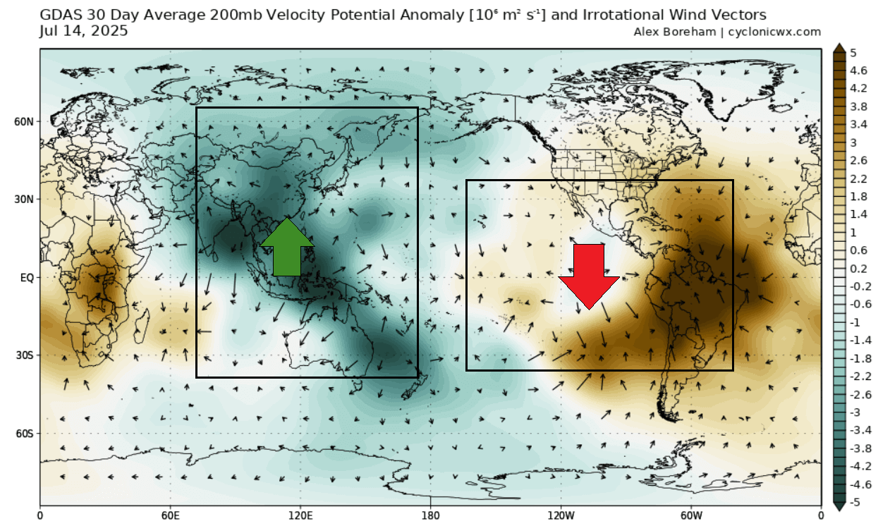
Based on this analysis, we can’t say that a cold ENSO signature is dominating the atmosphere, but at least the pattern shows more of a cold-neutral state. This has an impact on seasonal weather and also on weather in specific areas, such as the Atlantic Hurricane season.
But looking at the latest round of long-range predictions, a more proper La Niña is forecast to return.
A COLD ANOMALY RETURNS THIS WINTER
The latest long-range forecasts are starting to show an increasing cold Pacific anomaly for Winter 2025/2026 with each new calculation/run. This is a surprising shift, considering most forecasts earlier this year showed a neutral phase, with even some signs of an El Niño. But the atmosphere seems to play a different weather game.
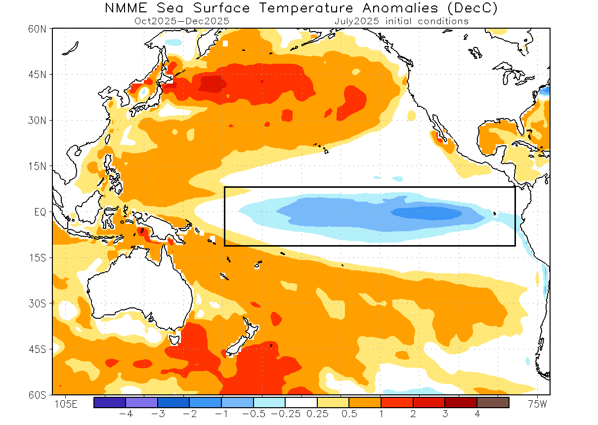
Below is the latest ocean temperature forecast for autumn and early winter from the North America NMME model. You can see an area of cold anomalies over the tropical Pacific, indicating a weak to moderate La Niña. Such an event can have a clear impact on the winter atmosphere.
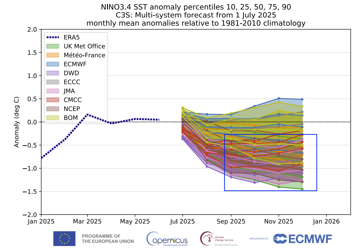
The long-range ensemble forecasts below show the forecast for the main ENSO region. The average forecast from all the calculations falls within the colder phase, with a high number of calculations well within the La Niña threshold. The weakest signal is from the ECMWF model, which has made a step towards La Niña since the previous run.
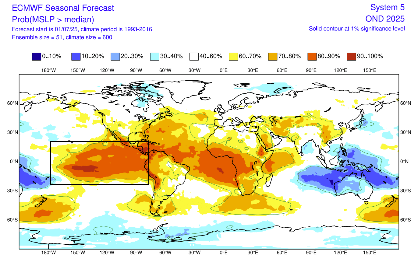
But if we look at the ECMWF pressure forecast for Fall and early Winter, you can actually see amplified high-pressure over the ENSO regions. There is a low-pressure anomaly over the Maritime Continent, which in total indicates a stronger Walker Circulation and a clear signature of an active La Niña.
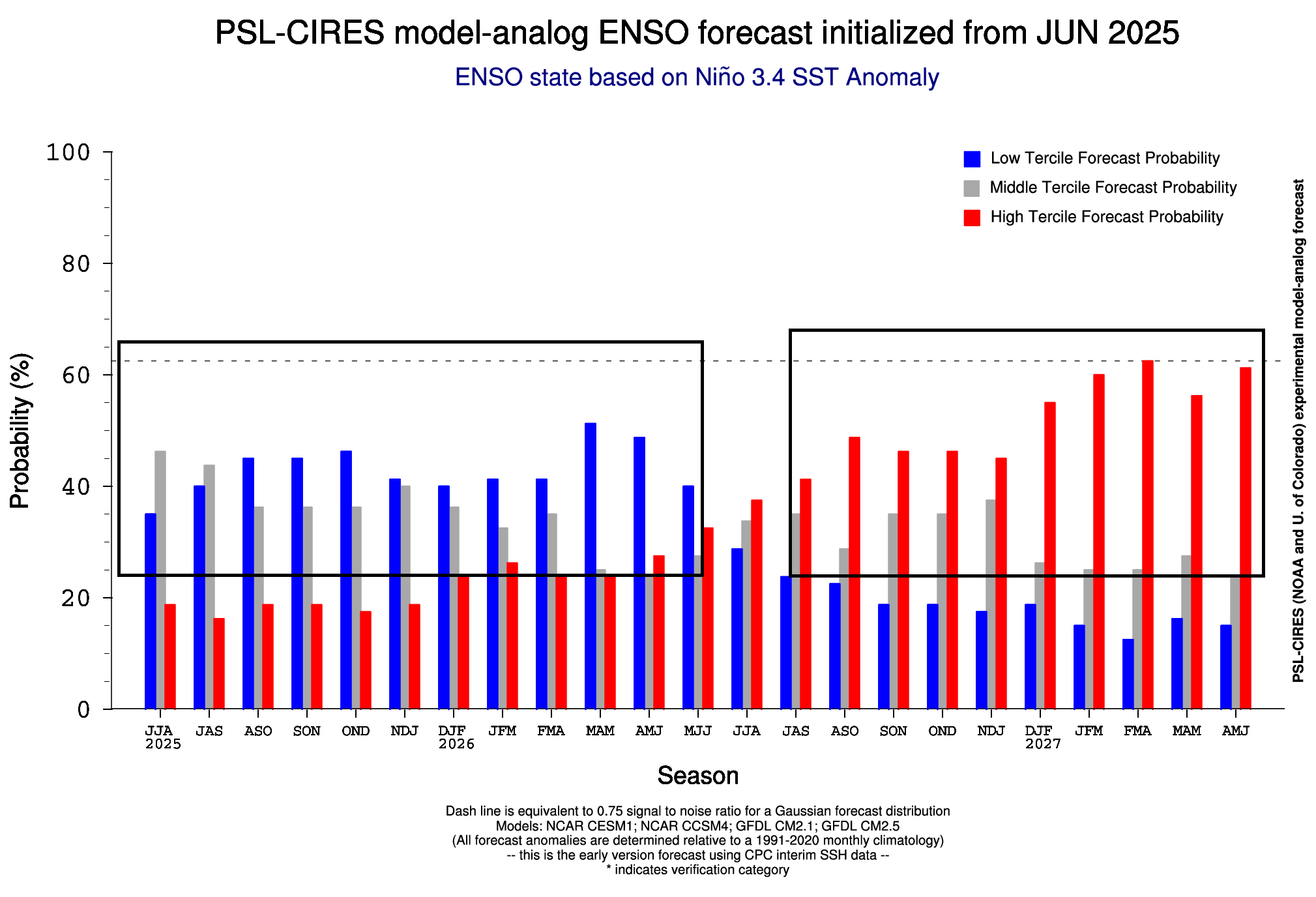
Shown here is an extended analog forecast from NOAA PSL for the main ENSO region. It shows a high probability for a La Niña return during the 2025/2026 cold weather season. There is also an increasing chance for a new El Niño event in 2026/2027, which we will monitor closely in the coming months.
So, what can a new La Niña phase bring for Winter 2025/2026? For that, we can look at some past winters and their resulting weather patterns.
LA NINA WINTER IMPACT OVER NORTH AMERICA
The most common effect of a cold ENSO phase (La Niña) is usually a strong blocking high-pressure system in the North Pacific. That redirects the polar jet stream down over the northern United States and southern Canada.
The circulation of the strong high-pressure system promotes the development of a low-pressure region over Alaska and western Canada. That pushes the jet stream downwards between the two strong pressure systems into the Northern United States.
The image below shows the jet stream redirection during a La Niña Winter, and the resulting weather patterns that develop over the United States and Canada.
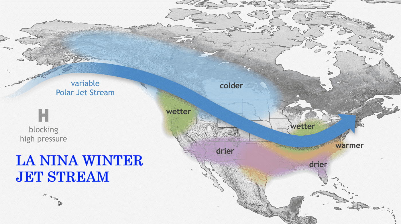
The displaced jet stream brings colder temperatures and winter storms from the polar regions down into the northern and northwestern United States. Warmer and drier winter weather prevails over the southern states.
Below is a Winter pressure anomaly during the weak La Niña events. You can see the expected high-pressure anomaly in the North Pacific. That shifts the jet stream and helps to create a low-pressure anomaly over Canada and the United States.
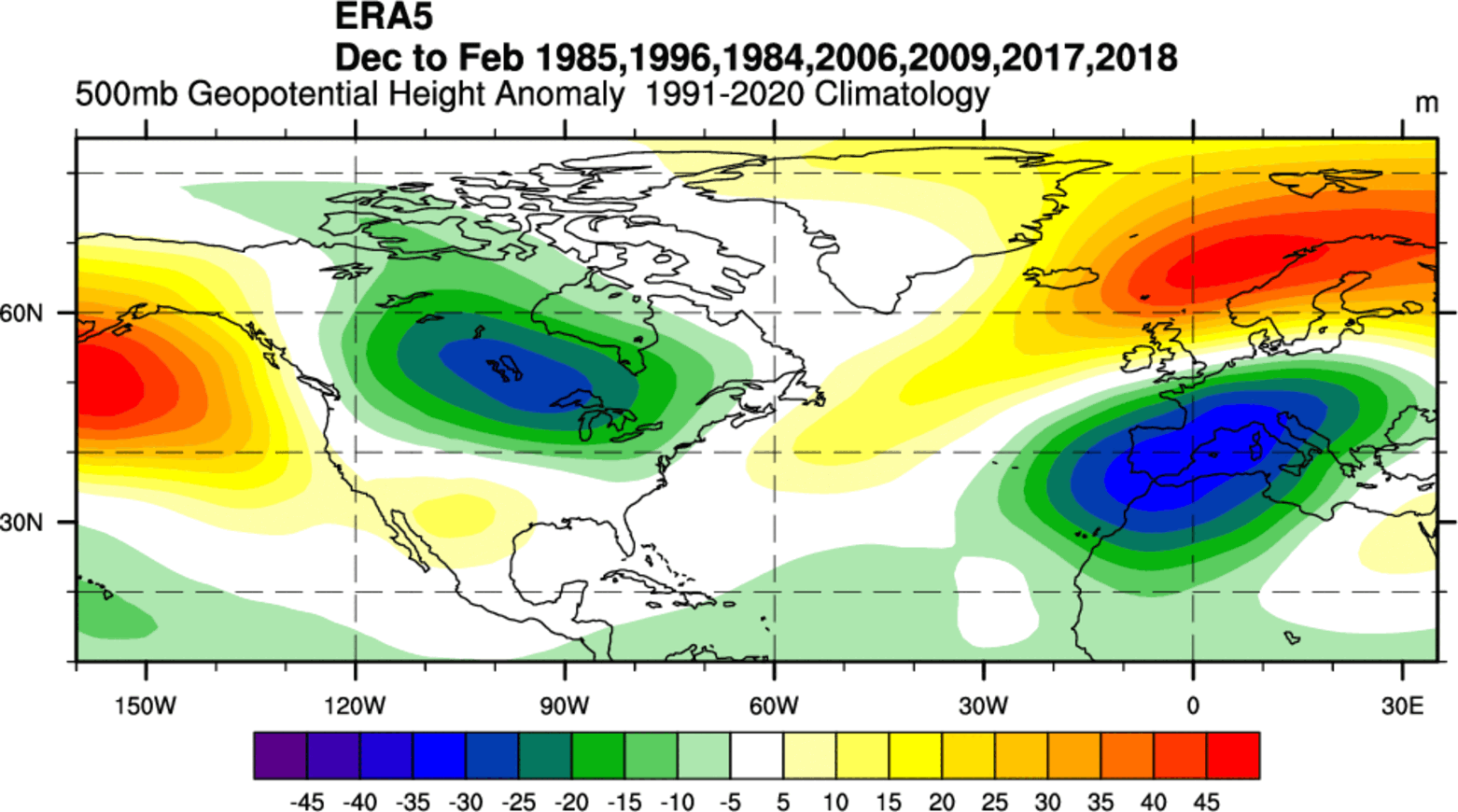
Over Europe, we see a low-pressure tendency over the southern parts, and higher pressure over the north. That creates a northerly flow over the continent.
Looking at the temperature analysis from the same data, you can see the cold anomaly area under the jet stream in western Canada, the northwestern United States. Negative anomalies extend over the Midwest and down into the central and eastern states.
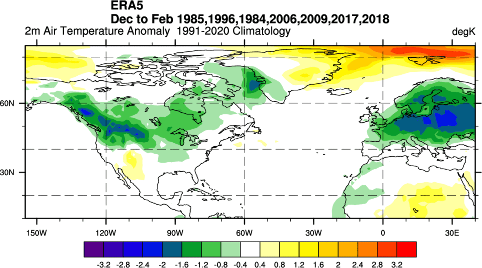
Warmer-than-normal weather and mild winter conditions develop in the southwestern United States and the far south. The main winter weather dynamics usually develop between these warm and cold anomalies in the Midwest and the east-central United States.
Europe shows a cold anomaly, resulting from a strong northerly and easterly flow. It’s unrealistic to expect this every La Niña, as this region is not under its direct influence like North America. This is likely due to a particularly cold winter or two in the mix of years.
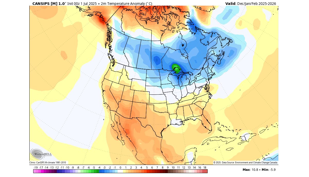
The only forecast that currently covers the whole Winter 2025/2026 season is from the Canadian CanSIPS. It also shows a weak La Niña developing, and as you can see below, it shows a cold pool over Canada and the northern United States, very similar to past analyses.
With the change in the jet stream, La Niña also significantly affects snowfall potential over North America, as pressure systems take a different path.
As the colder air is more accessible to the northern United States and southern Canada during a La Niña winter, that increases the snowfall potential if moisture is available. In the image below, you can see the average snowfall pattern for all La Niña years.
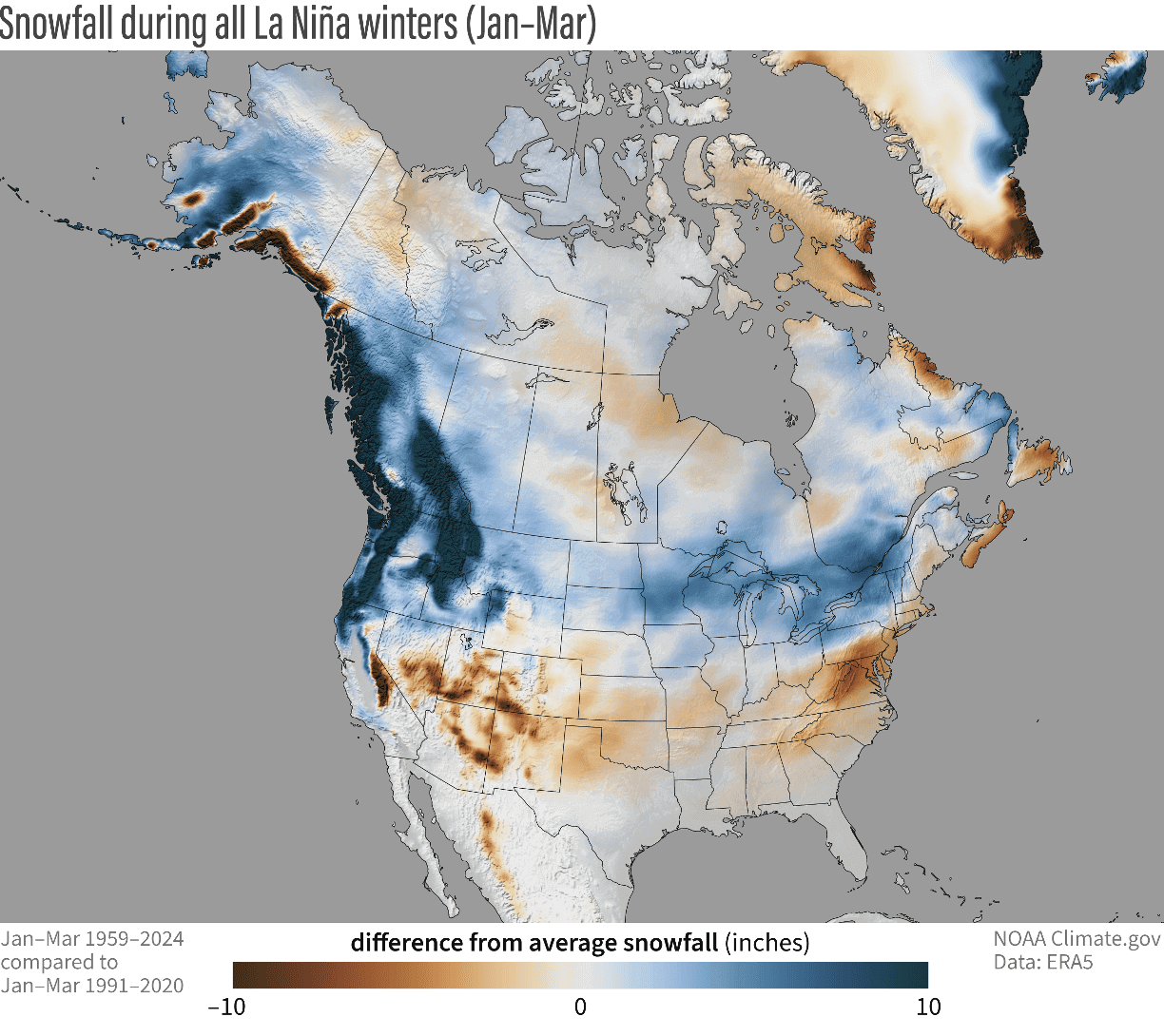
You can see above-average snowfall across much of the northern United States and southern Canada. Peak snowfall is usually across the higher elevations of the Pacific Northwest. But in other areas, states like Minnesota, Wisconsin, Michigan, New York, Vermont, and northern Pennsylvania stand out with more snowfall in such winters.
The southern United States usually experiences less snowfall in such winters because the jet stream is more confined to the northern states. But with the cold pool so close in western Canada, strong cold events and snowfall can extend far south and cover the whole eastern United States.
La Niña also has a Winter impact that exceeds the lower levels, and can reach high up into the Stratosphere.
A POLAR VORTEX CONNECTION
One of the important winter factors is the Polar Vortex. This is a term that describes the Winter circulation over the Northern (Southern) Hemisphere, spanning from the surface levels all the way up into the top of the Stratosphere.
Historically, a La Niña winter has around a 60-75% chance of producing a Stratospheric Warming Event (SSW), which is a Polar Vortex collapse. It has produced them in the past and also in more recent winters. The image below shows the typical SSW event frequency by month and by the ENSO event.
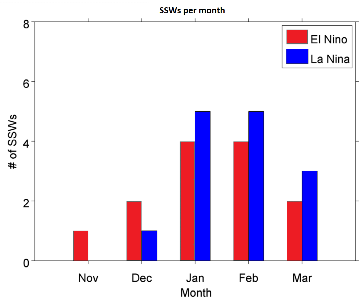
As you can see, a La Niña phase has a higher chance of producing a Polar Vortex collapse event. It also produces one a bit later in the season, which is what we saw this winter. Overall, this means that a La Niña event is favorable for a weaker Polar Vortex.
A weak Polar Vortex creates a disrupted jet stream pattern and a strong weather response. As a result, it has a harder time containing the cold air, which can now more freely escape from the polar regions into the United States or other mid-latitude regions.
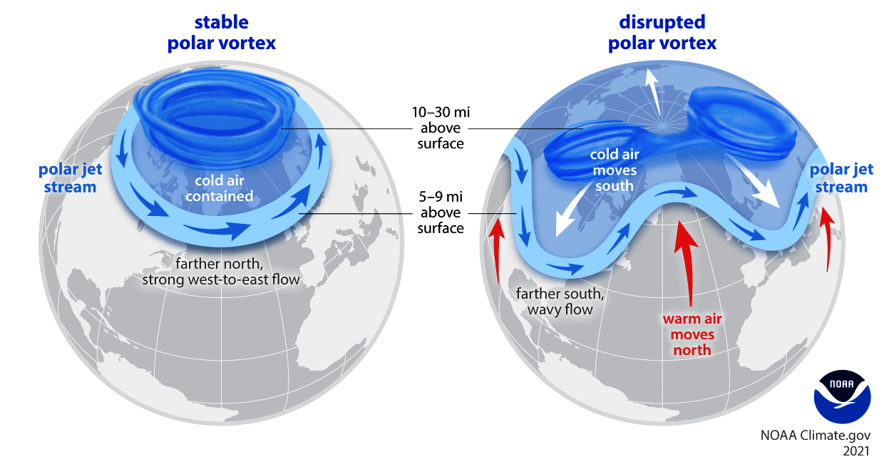
So, if you want a colder and snowier Winter, your best bet is a weak Polar Vortex. In nature, a weak Polar Vortex essentially means a breakdown of the stratospheric Polar Vortex, resulting in the spill-out of cold air from the polar regions.
Below is an image that shows typical winter pressure anomalies over the North Pacific and North America for each ENSO phase. The third example shows the best pressure pattern to disrupt the Polar Vortex in winter and start a warming event in the stratosphere.
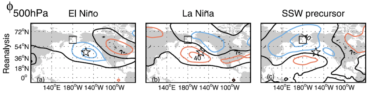
As you can see, the La Niña pattern is overall a bit more favorable for a weaker Polar Vortex. This means that it makes it easier for winter weather patterns to be disrupted, bringing colder weather and snowfall to the United States and Europe.
This is just one of the factors that currently suggests a high potential for weaker winter circulation due to the La Niña. For a more in-depth analysis, you can read our latest article: Polar Vortex predictions for Winter 2025/2026
We will keep tracking the latest global weather patterns and forecasts, so be sure to bookmark our page to stay updated. If you found this article in the Google App (Discover), tap the ♥ or star to see more of our weather and nature coverage in your feed.