The La Niña event in the Pacific has officially ended. But while it is gone in the oceans, it can still leave a trace in the Atmosphere. But the latest analysis and forecasts show a more dynamic Summer pattern over the United States and Canada, with some interesting early hints emerging also for Winter 2025/2026.
The global climate is very sensitive to large-scale ocean changes, especially the temperature and wind patterns. For this reason, we closely monitor these anomalies, as they can significantly influence seasonal weather patterns.
We will look at the latest changes across the Pacific and how the atmosphere is adjusting to the end of the La Niña phase. You will see how such transitions have affected the Summer weather over the United States and Canada, and also some early projections for the potential Winter development.
WHEN ENSO PHASES CHANGE
The La Niña we mentioned is a cold phase of the ENSO phenomenon, which stands for “El Niño Southern Oscillation.” This is a region of the Pacific Ocean that periodically shifts between warm and cold phases. Typically, there is a phase change around every 1-3 years.
Each phase (cold/warm) usually develops between late summer and early Fall and typically lasts until Spring. But some events can last up to two or three years, as seen just a few years ago.
The cold ENSO phase is called La Niña, and the warm phase is El Niño. Besides the temperatures, one of the main differences between the phases is the pressure patterns they develop, seen below as high (H) and low (L) pressure zones.

During an El Niño, the pressure over the tropical Pacific is lower, with more rainfall and storms in this region.
But during a La Niña, the pressure rises over the region, creating stable conditions and fewer storms over the equatorial Pacific. These pressure changes translate into global circulation over time, affecting seasonal weather over both Hemispheres.
Below is the anomaly data across the ENSO region since early 2024. You can see the ocean temperature drop starting in December, and going lowest in January, but ending the cold phase in March. The gray lines are past La Niña events. As you can see, they were all typically coldest around January.

But looking ahead, you can see that plenty of those past La Niña events have evolved into an El Niño event before next Winter (red area). There are also many events where the La Niña returned for next winter.
Below is the latest ocean analysis with the main ENSO regions marked in the image. You can see that colder-than-normal waters are very weak and dispersed compared to a proper La Niña anomaly in the image above.
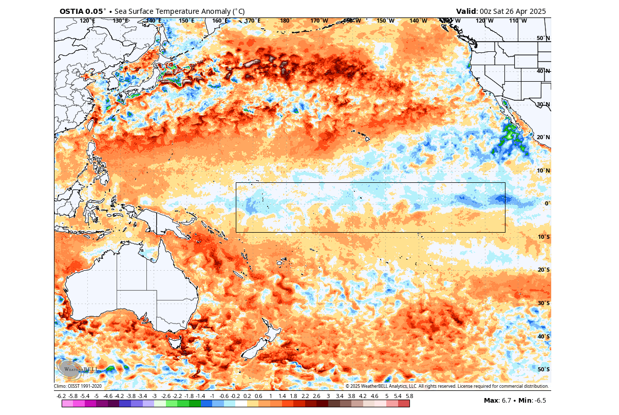
You can also see that warmer anomalies are emerging in the ENSO area. This has raised the overall temperature in the region, officially ending the weak La Niña phase of the 2024/2025 season.
Looking closer at the anomalies in the past 4 months, we produced a video from the official monthly ocean analysis. As you can see, it shows the weakening of the cold anomalies and the emergence of warmer waters, ending the La Niña phase.
But these anomalies involve more than just ocean surface temperatures. In the big picture, there are also wind patterns and subsurface anomalies at play.
THE COLD PHASE ENDS
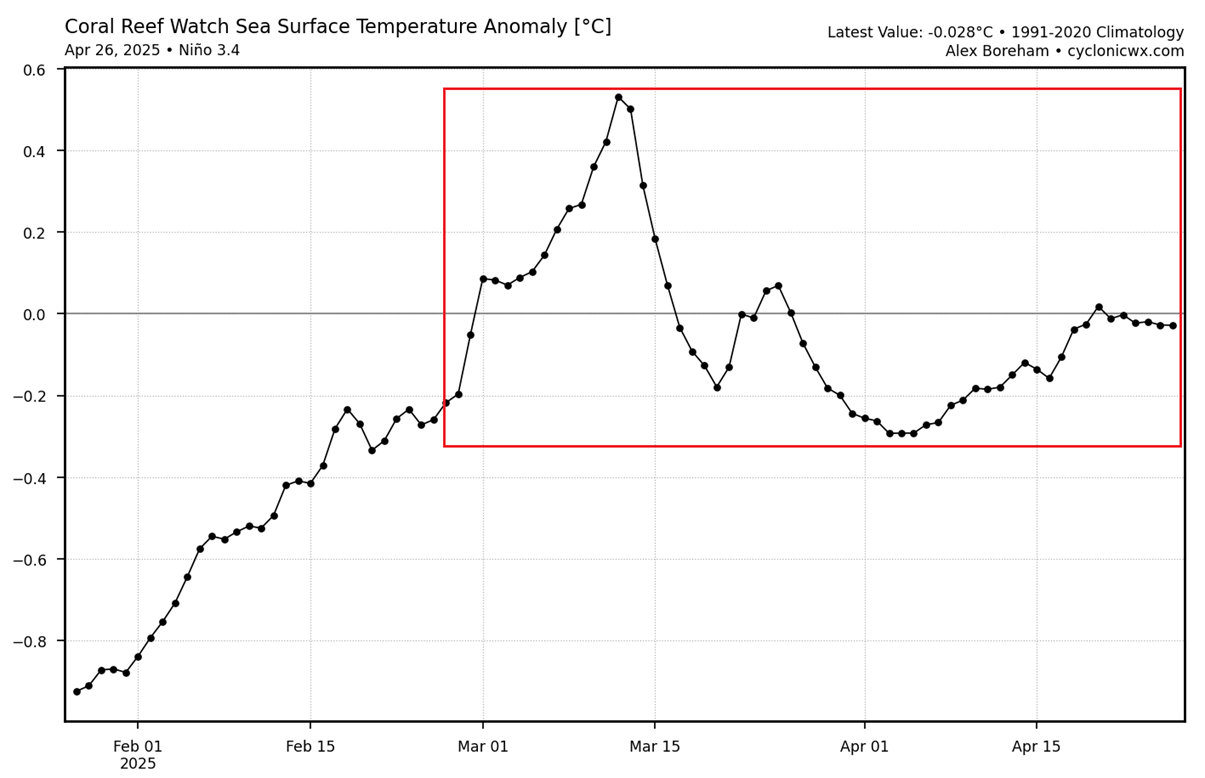
The graph below shows the ocean temperature anomaly for the main ENSO 3.4 region since late January. You can see that after a strong cooling period, the ocean surface temperatures in the area were steadily rising, reaching warm anomalies in March. Since then, the temperatures have been around neutral values with the La Niña officially ending.
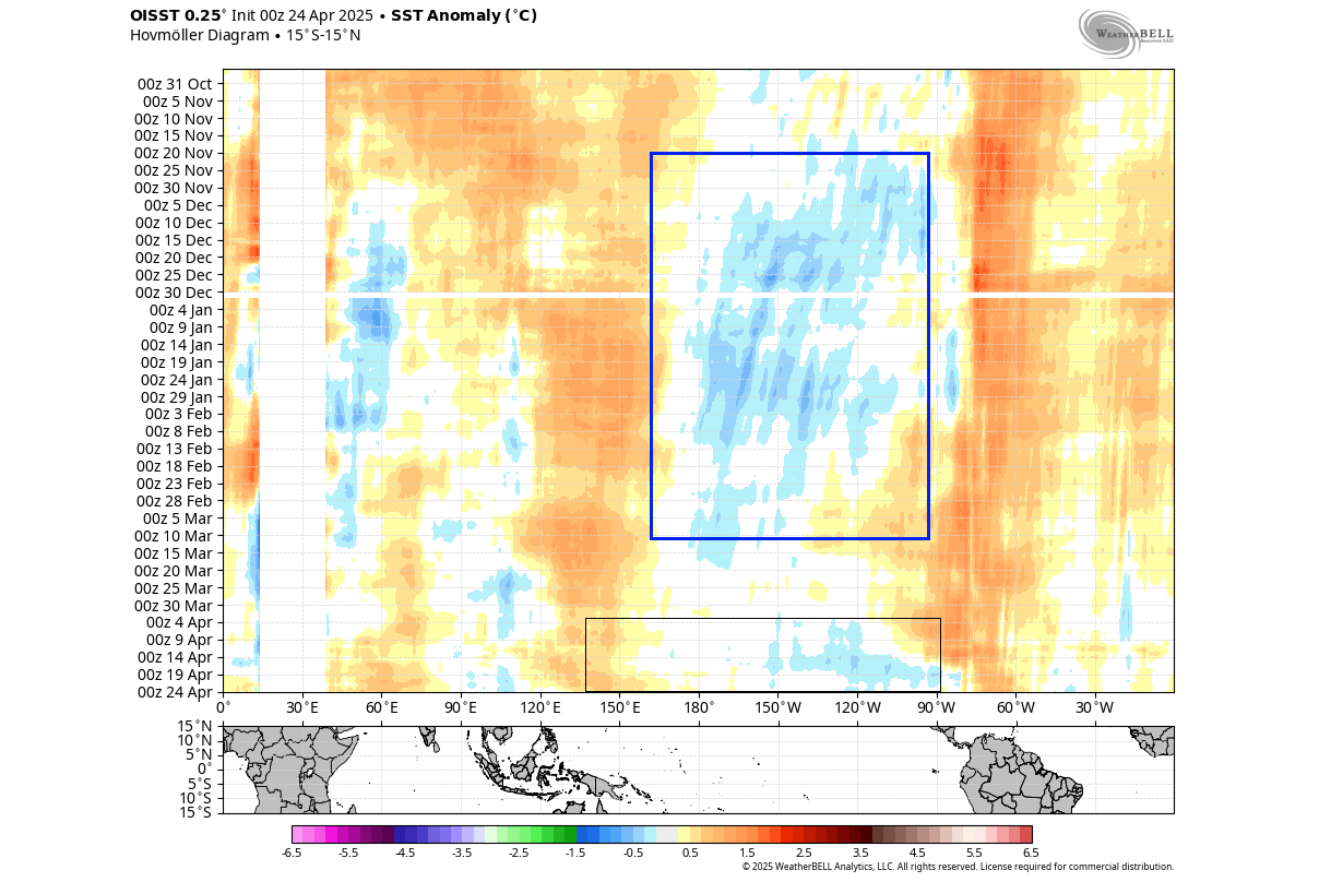
Looking at the wider region below, the graphic shows the ocean surface anomalies over time. Here, you can even better see the widespread cooling across the central Pacific area from November to February. But the cold anomalies have broken down since March, and you can see a neutral phase starting in April.
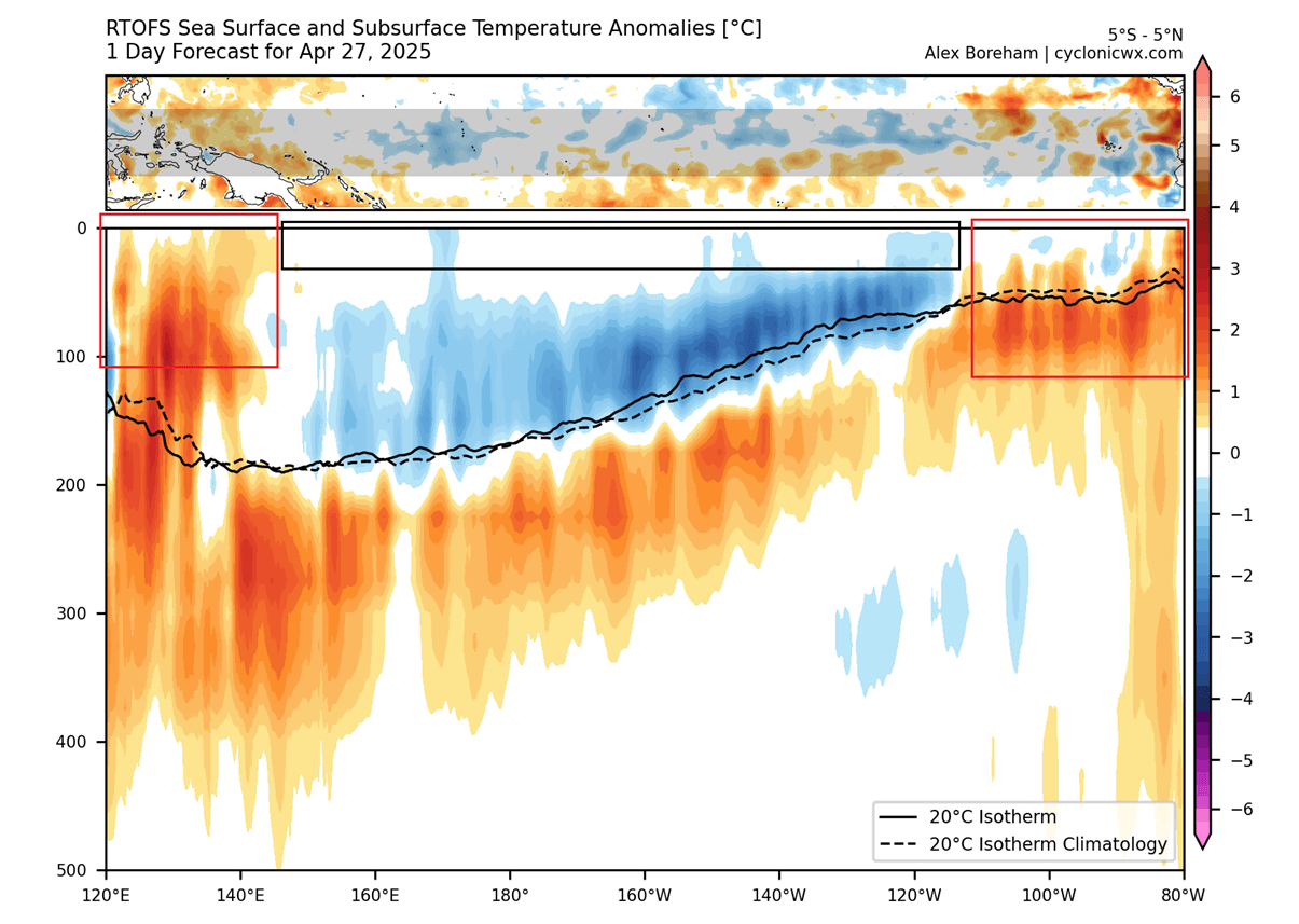
The activity below the ocean surface is also very important in the grand scheme. The image below shows the subsurface ocean anomaly by depth. The cold pool of the La Niña is still visible in the central Pacific basin down to around 150m (500ft) depth. But its surface features have been eroded, with warmer waters also rising in the eastern regions.
Knowing how the La Niña has ended and how it progressed over winter, we can look at some past such events, to find some clues for the upcoming weather seasons.
ATMOSPHERIC CHANGES BEGIN
As mentioned, La Niña has a well-known atmospheric impact during the Winter and Spring seasons. But after the La Niña ends, its atmospheric effects slowly disappear. And this season we are also expected to see some atmospheric changes, as the ENSO changes from cold to neutral phase.
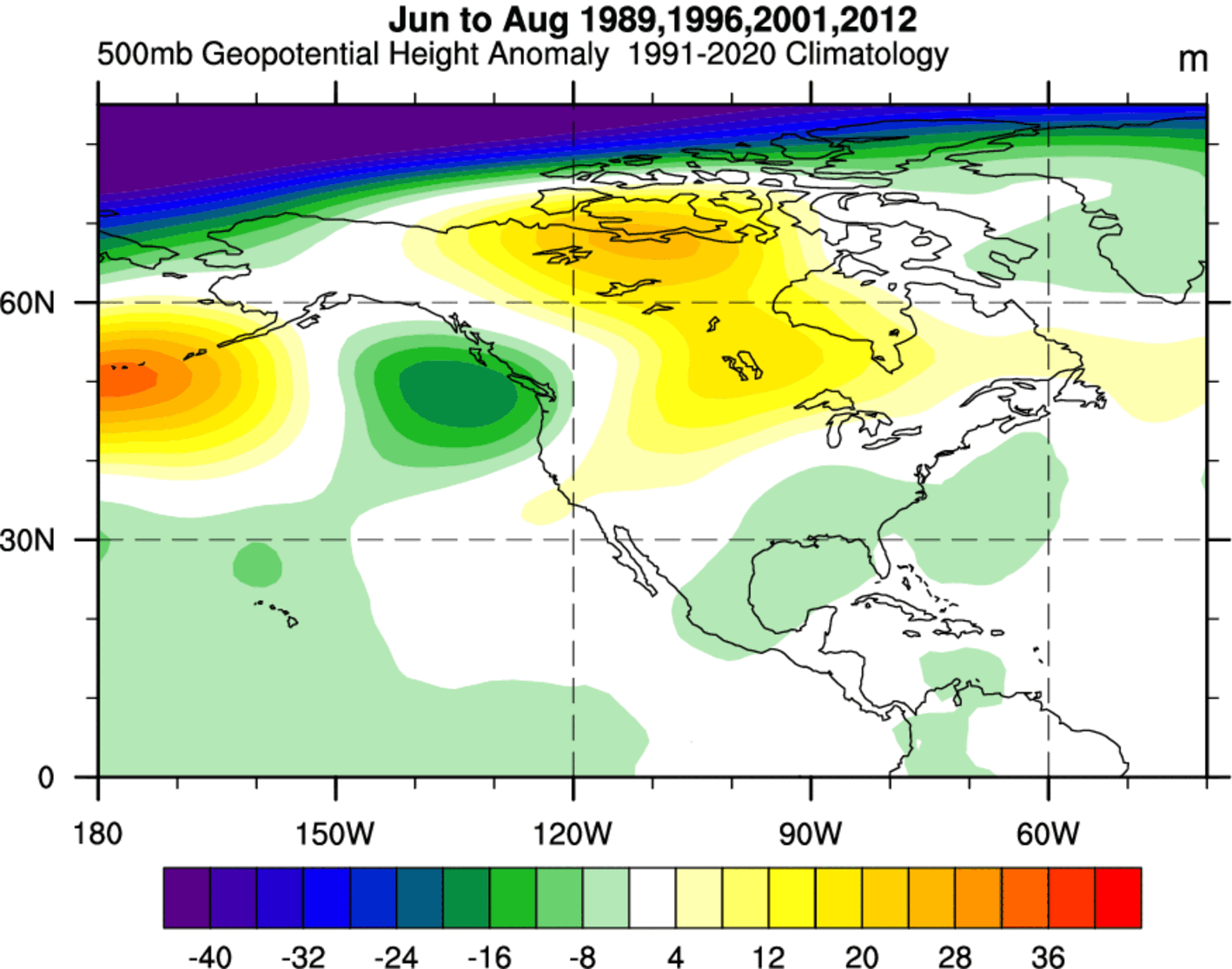
We went over the data, and found a few years that had a similar progression with a La Niña going into a stable neutral phase. Gathering the data from all the selected years, we produced two images for the pressure and temperature patterns for the following summer.
First, we have the pressure anomaly for the summer season in those years. What stands out is a high-pressure area over Canada, also covering the northern and western United States and eastern Canada. But over the southern and eastern United States, there is a weak indication of a low-pressure area.
Looking at the actual latest pressure forecast for summer, you can see similar features. A high-pressure area over the western United States, extending into Canada, and another area over eastern Canada. There is an indication of a low-pressure zone likely over the eastern parts of the United States.
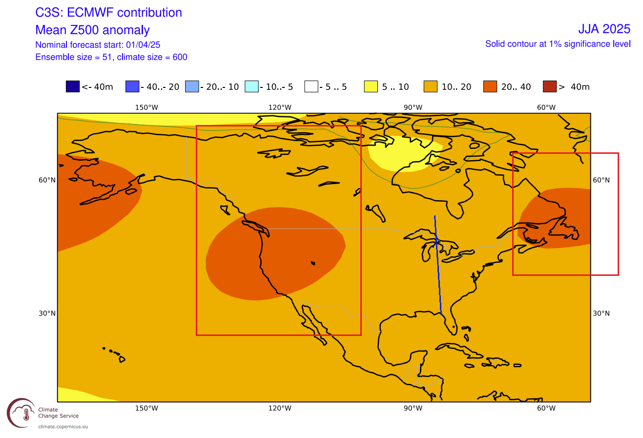
This shows us that some atmospheric features can result from having similar oceanic conditions. So, compared to the actual forecast, it seems that the models also see a similar development this year.
If we look at the temperature in those past years, there is a warm anomaly under the high-pressure zones. Above normal temperatures were recorded over most of the western and northern United States, and over Canada.
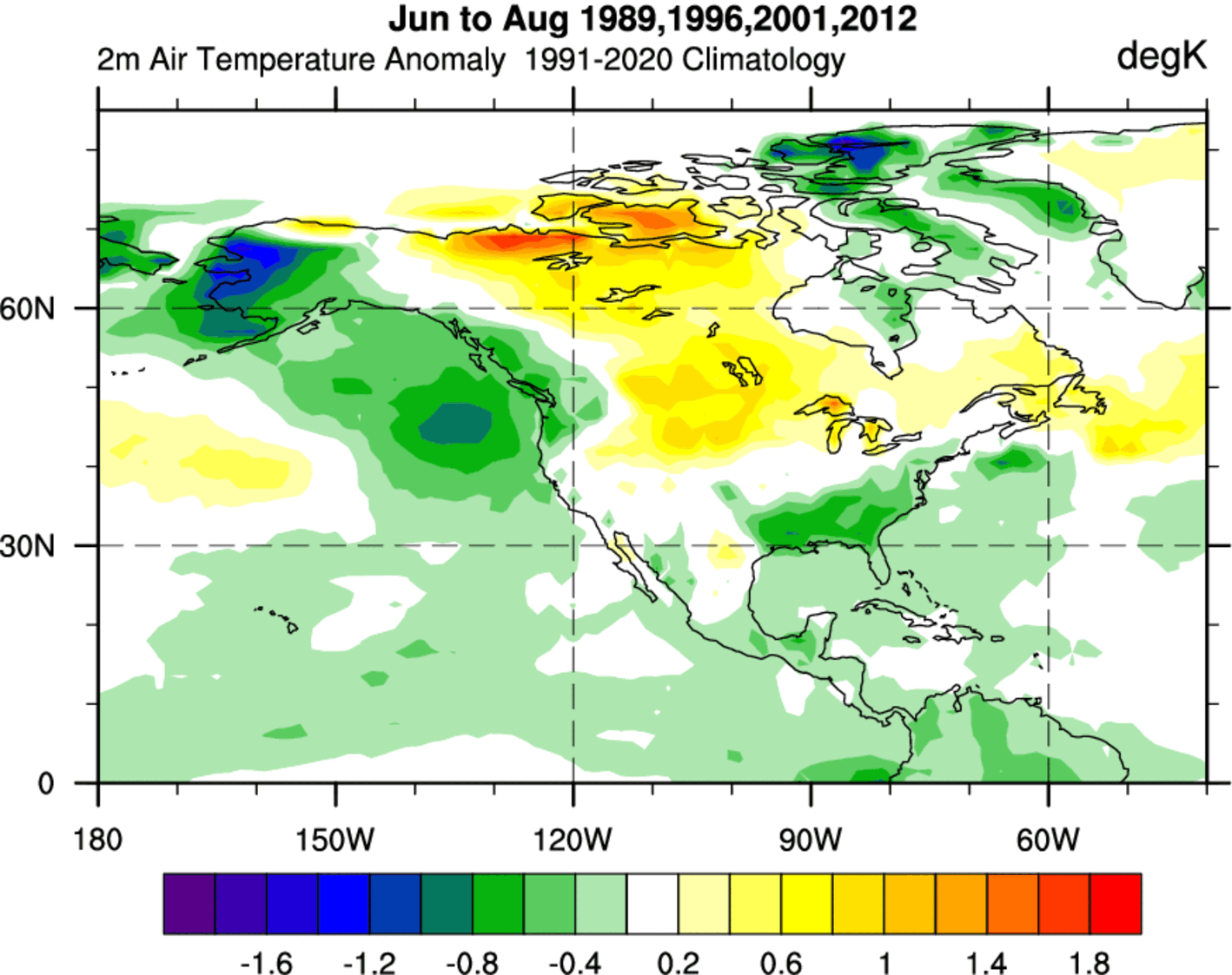
An interesting feature is a below-normal temperature area over the eastern United States and over the Pacific Northwest.
The actual summer temperature forecast actually shows a large area of above-normal temperatures over the western and central United States and southwestern Canada. While we do not see any below normal temperatures forecast over the eastern United States, we do see an area of near normal temperatures.

Also, compared to the western half of the United States, this area has a visibly lower temperature anomaly, courtesy of the low-pressure zone in the area.
Interesting patterns are developing, which are a bit different than the unusually high temperatures across the whole continent. At least for now, all indicators show a rather tame or normal summer over the eastern United States.
But to long further out, we first need to see what the long-range forecasts show for the ENSO phase, if it will stay neutral or could we see a new warm phase emerge?
LONG-RANGE PREDICTIONS
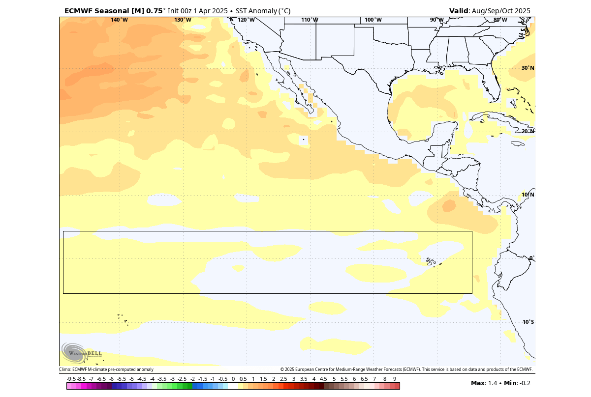
Below is the latest ECMWF ocean forecast for late summer and early autumn. It shows a lack of any significant anomalies, either warm or cold. This indicates a continuation of a neutral phase into Autumn, and likely towards Winter 2025/2026.
Long-range ensemble forecasts below show the forecast for the main ENSO region. The average forecast from all the calculations is within the warm-neutral phase, with a high number of calculations going into the warm phase territory. But for now, the consensus is for a neutral phase in Autumn and Winter.

Below is also an extended analog forecast from the Physical Science Laboratory for the main ENSO region. It shows the highest chance that a neutral phase will continue throughout autumn and winter. There is also a chance for a new La Niña event, but based on the past years, that scenario is at the present time less likely.

What stands out is an increased chance for a new El Niño event in 2026. We will keep a close eye on the developing forecasts and trends, in case an El Niño makes an early appearance.
So, what could a stable neutral phase mean for Winter 2025/2026? For that, we can look at the same years we used for the summer analogy.
ATMOSPHERIC CHANGES FOR WINTER 2025/2026
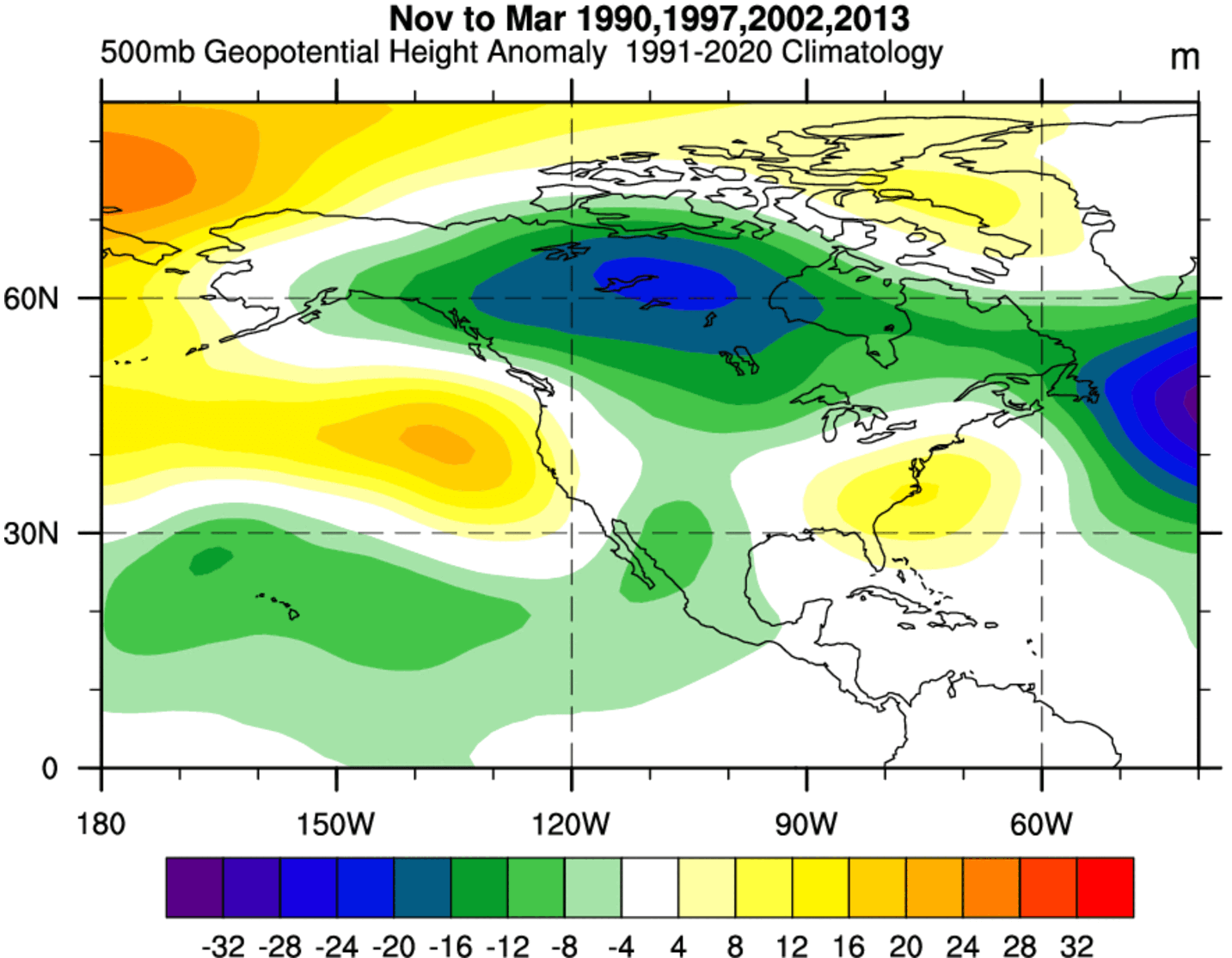
We will look at the November to March period, which covers the whole cold weather season. The pressure pattern analysis shows that these neutral seasons after a La Niña tend to have a broad low-pressure area over Canada, and a high-pressure zone over the North Pacific.
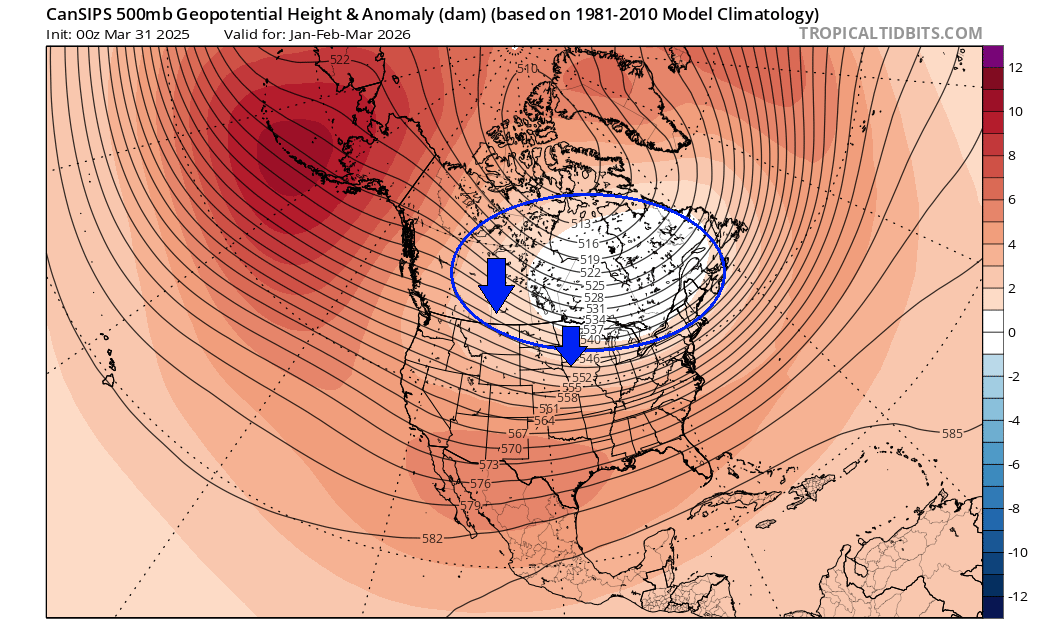
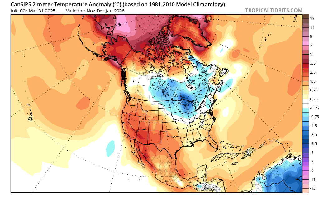
While there is currently no forecast in that range that would actually be useful in any way, we do have CanSIPS data. This is not meant as an actual forecast, as the range is far too long, but it does serve as an example of a forecasting trend that actually follows the same idea as past seasons have shown. A low-pressure zone over Canada and a high-pressure zone in the North Pacific.
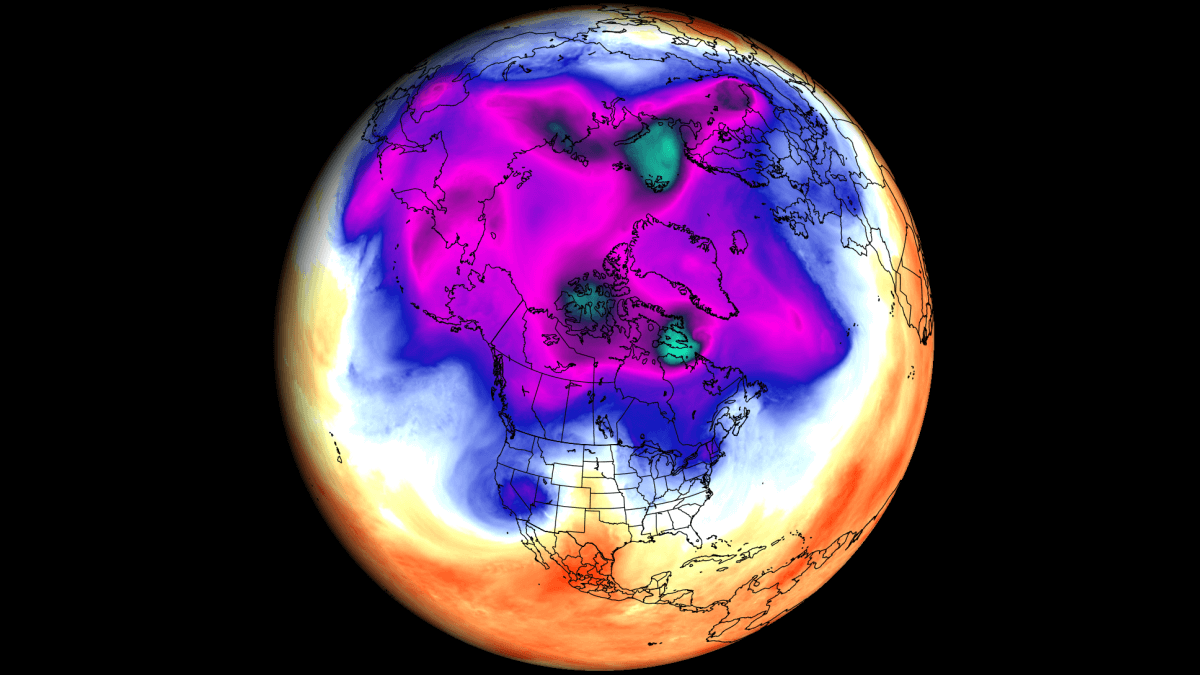
Looking at precipitation, we see the analysis showing a broad area of cold air over western Canada. This is because of the low-pressure systems that spin anti-clockwise, which create a strong northerly flow over western Canada and over the northern and western United States in certain conditions.
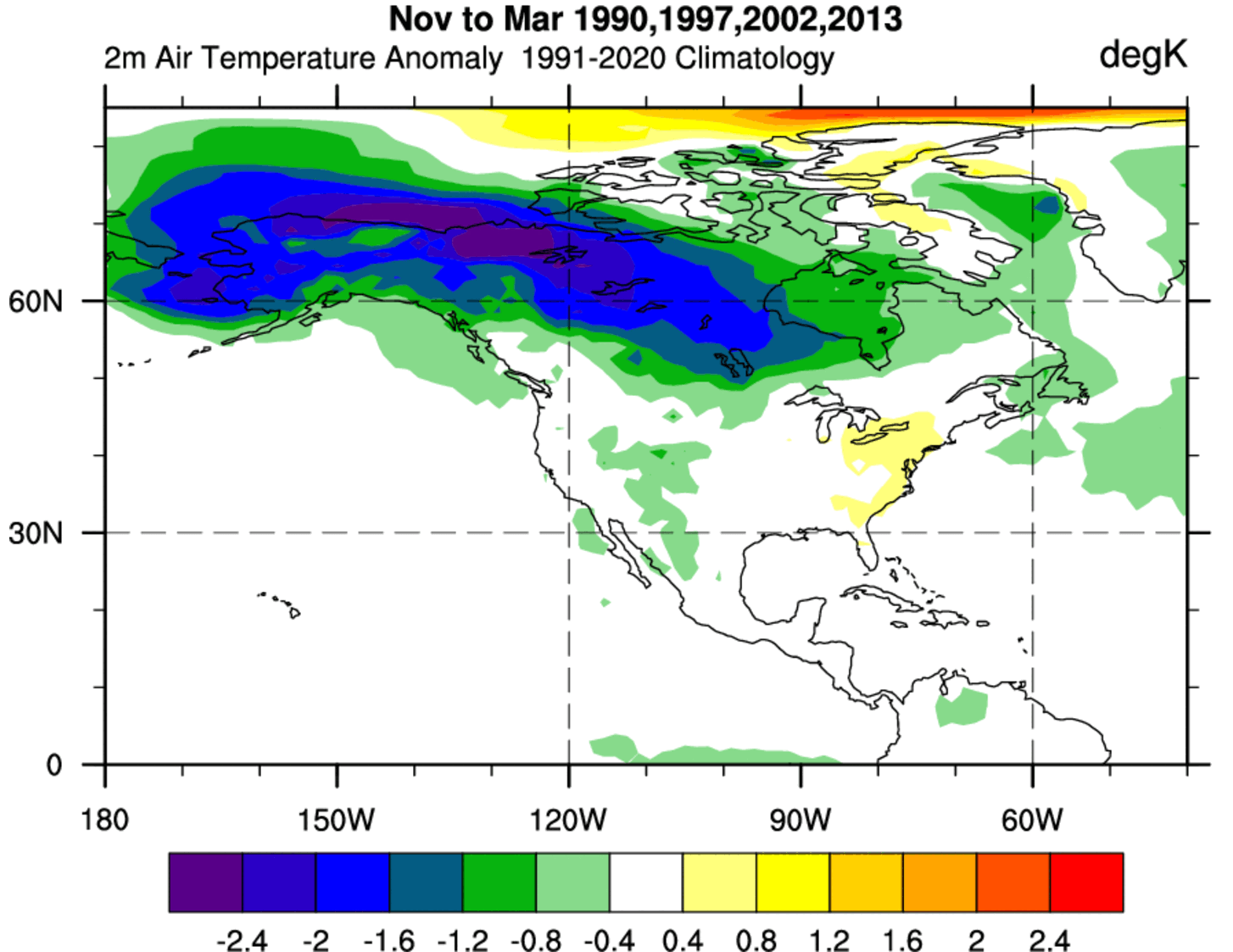
That northerly flow brings colder air down from the polar regions, and creates a broad area of cold air reserve. That air can be sent or released into the United States when the pattern re-adjusts and a low-pressure system drops into the United States.
Looking at the CanSIPS projection, again, it is not meant as a true forecast, but is just to compare to the analysis image above. And you can see that this model does show a large cold-air reserve, and even moves it deeper into the United States.
This is essentially just an analysis of specific past winters, but it has a certain forecasting value. Just like 1+1 equals 2, we can also see in the weather how a combination of certain global factors can produce a similar winter season more than once.
We will keep you updated on other developing weather trends, so bookmark our page. Also, if you have seen this article in the Google App (Discover) feed, click the like button (♥) there to see more of our forecasts and our latest articles on weather and nature in general.
Don’t miss: Significant severe weather – tornado outbreak across the Upper Midwest on Monday